
Melbourne tram route 1
Encyclopedia
Tram
route 1 is a public transport
service in Melbourne
, Victoria
, Australia
. It runs from the terminus at Nicholson Street and Bell Street in East Coburg
to the corner of Victoria Avenue and Beaconsfield Parade in Albert Park
.
Like most tram routes in Melbourne, it is entirely within Metcard
/myki
ticketing Zone 1.
A rare 1970s silk screen print by Canadian-Australian artist Ed Goodson, was titled Tram No. 1 South Melbourne Beach.
from Collins Street
to South Melbourne Beach, a cable tram along Swanston Street and St Kilda Road, an electric line from Queensberry Street to East Coburg and a section of track between Clarendon Street and St Kilda Road.
Cable trams first travelled from Queensberry Street, Carlton
to Milton Street, Balaclava
, on 11 October 1888, with the line opened by the Melbourne Tramway and Omnibus Company.
A cable tram between Collins Street and South Melbourne Beach, travelling Market Street, Queens Bridge Street, City Road, Clarendon Street, Park Street, Montague Street, Bridport Street and Victoria Avenue was opened on 17 June 1890, by the Melbourne Tramway and Omnibus Company.
The Melbourne, Brunswick and Coburg Tramways Trust started building its tramway system in June 1914, on 31 October 1916 East Coburg was connected to Melbourne
at Queensberry Street along Nicholson Street, Holmes Street, Lygon Street, Elgin Street and Madeline Street - as the section of Swanston Street
north of Victoria Street was originally known.
The Melbourne and Metropolitan Tramways Board constructed a track connecting Clarendon Street and St Kilda Road along Sturt Street, Eastern Road, Heather Street and Park Street, which opened on 31 October 1925.
The Melbourne and Metropolitan Tramways Board converted the Swanston Street/St Kilda Road cable line to electric traction between 1924 and 1926, with electric trams able to run the entire length on 29 August 1926.
The Market Street cable lines were mainly converted - the Port Melbourne cable tram line, including the Hannah Street (now Kings Way) to Clarendon Street section of City Road was abandoned in favour of buses - to electric traction by the Melbourne and Metropolitan Tramways Board, with the first service to South Melbourne Beach on 25 July 1937.
As part of the City Road and St Kilda Road separation project, the northern most section of track along Sturt Street was relocated to Nolan Street (now Southbank Boulevard) on 16 March 1970.
 Route 1 runs from East Coburg
, travelling south on Nicholson Street from Bell Street through Coburg
to Brunswick East
where Nicholson Street becomes Holmes Road. It continues south to Albion Street where it doglegs into Lygon Street, Brunswick East, continuing south through Carlton North
and Carlton
, turning west into Elgin St and south into Swanston Street
at Melbourne University
.
It passes through the CBD
on Swanston Street, passing Royal Melbourne Institute of Technology
, Melbourne Central railway station
, State Library of Victoria
, Melbourne Town Hall
, City Square
, St Paul's Cathedral
, Flinders Street railway station, Federation Square
and Birrarung Marr.
Crossing the Yarra River
into Southbank along St Kilda Road, it passes The Arts Centre
and National Gallery of Victoria
before turning west into Southbank Boulevard, quickly turning south onto Sturt Street, passing the Melbourne Recital Hall and Victorian College of the Arts. It briefly travels south on Eastern Road and Heather Street to Park Street, South Melbourne
where it travels west to Montague Street Albert Park
, and travels south, turning west into Bridport Street and continuing to its terminus in Victoria Avenue at Beaconsfield Parade.
and B2 class
trams.
Tram
A tram is a passenger rail vehicle which runs on tracks along public urban streets and also sometimes on separate rights of way. It may also run between cities and/or towns , and/or partially grade separated even in the cities...
route 1 is a public transport
Public transport
Public transport is a shared passenger transportation service which is available for use by the general public, as distinct from modes such as taxicab, car pooling or hired buses which are not shared by strangers without private arrangement.Public transport modes include buses, trolleybuses, trams...
service in Melbourne
Melbourne
Melbourne is the capital and most populous city in the state of Victoria, and the second most populous city in Australia. The Melbourne City Centre is the hub of the greater metropolitan area and the Census statistical division—of which "Melbourne" is the common name. As of June 2009, the greater...
, Victoria
Victoria (Australia)
Victoria is the second most populous state in Australia. Geographically the smallest mainland state, Victoria is bordered by New South Wales, South Australia, and Tasmania on Boundary Islet to the north, west and south respectively....
, Australia
Australia
Australia , officially the Commonwealth of Australia, is a country in the Southern Hemisphere comprising the mainland of the Australian continent, the island of Tasmania, and numerous smaller islands in the Indian and Pacific Oceans. It is the world's sixth-largest country by total area...
. It runs from the terminus at Nicholson Street and Bell Street in East Coburg
Coburg, Victoria
Coburg is a suburb in Melbourne, Victoria, Australia, 8 km north from Melbourne's central business district. Its Local Government Area is the City of Moreland, although a handful of properties on Coburg's Eastern boundary are located in the City of Darebin...
to the corner of Victoria Avenue and Beaconsfield Parade in Albert Park
Albert Park, Victoria
Albert Park is an inner city suburb of Melbourne, Victoria, Australia, 3 km south from Melbourne's central business district. Its Local Government Area is the City of Port Phillip. At the 2006 Census, Albert Park had a population of 5827....
.
Like most tram routes in Melbourne, it is entirely within Metcard
Metcard
"OneLink" redirects here. For the computer/cable company, see OneLink Communications.Metcard is the brand name of an integrated ticketing system used to access public transport in Melbourne, Australia. It is a universal ticket which allows users to ride on the city's Metlink network, consisting of...
/myki
Myki
myki is the contactless smartcard ticketing system being introduced on public transport in Victoria, Australia. myki is designed to replace a number of ticket systems in Victoria, primarily the Metcard and V/Line ticketing systems...
ticketing Zone 1.
A rare 1970s silk screen print by Canadian-Australian artist Ed Goodson, was titled Tram No. 1 South Melbourne Beach.
History
The origins of route 1 lie in separate tram lines, a cable tramCable car (railway)
A cable car or cable railway is a mass transit system using rail cars that are hauled by a continuously moving cable running at a constant speed. Individual cars stop and start by releasing and gripping this cable as required...
from Collins Street
Collins Street, Melbourne
Collins Street is a major street in the Melbourne central business district and runs approximately east to west.It is notable as Melbourne's traditional main street and best known street, is often regarded as Australia's premier street, with some of the country's finest Victorian era buildings.The...
to South Melbourne Beach, a cable tram along Swanston Street and St Kilda Road, an electric line from Queensberry Street to East Coburg and a section of track between Clarendon Street and St Kilda Road.
Cable trams first travelled from Queensberry Street, Carlton
Carlton, Victoria
Carlton is an inner city suburb of Melbourne, Victoria, Australia, 2 km north from Melbourne's central business district. Its Local Government Area is the City of Melbourne...
to Milton Street, Balaclava
Balaclava, Victoria
Balaclava is a suburb of Melbourne, Victoria, in Australia. It is situated in the south-east of the city in the St Kilda East area and is bounded by Inkerman Street to the north, Chapel Street to the west, Hotham Street to the east and Oak Grove and Los Angeles Court to the south. In terms of its...
, on 11 October 1888, with the line opened by the Melbourne Tramway and Omnibus Company.
A cable tram between Collins Street and South Melbourne Beach, travelling Market Street, Queens Bridge Street, City Road, Clarendon Street, Park Street, Montague Street, Bridport Street and Victoria Avenue was opened on 17 June 1890, by the Melbourne Tramway and Omnibus Company.
The Melbourne, Brunswick and Coburg Tramways Trust started building its tramway system in June 1914, on 31 October 1916 East Coburg was connected to Melbourne
Melbourne city centre
Melbourne City Centre is an area of Melbourne in Victoria, Australia. It is not to be confused with the larger local government area of the City of Melbourne...
at Queensberry Street along Nicholson Street, Holmes Street, Lygon Street, Elgin Street and Madeline Street - as the section of Swanston Street
Swanston Street, Melbourne
Swanston Street is a major thoroughfare in the centre of Melbourne, Australia. It is historically one of the main streets of central Melbourne, laid out in 1837 as part of the Hoddle Grid, the layout of major streets that makes up the central business district...
north of Victoria Street was originally known.
The Melbourne and Metropolitan Tramways Board constructed a track connecting Clarendon Street and St Kilda Road along Sturt Street, Eastern Road, Heather Street and Park Street, which opened on 31 October 1925.
The Melbourne and Metropolitan Tramways Board converted the Swanston Street/St Kilda Road cable line to electric traction between 1924 and 1926, with electric trams able to run the entire length on 29 August 1926.
The Market Street cable lines were mainly converted - the Port Melbourne cable tram line, including the Hannah Street (now Kings Way) to Clarendon Street section of City Road was abandoned in favour of buses - to electric traction by the Melbourne and Metropolitan Tramways Board, with the first service to South Melbourne Beach on 25 July 1937.
As part of the City Road and St Kilda Road separation project, the northern most section of track along Sturt Street was relocated to Nolan Street (now Southbank Boulevard) on 16 March 1970.
Route
Coburg, Victoria
Coburg is a suburb in Melbourne, Victoria, Australia, 8 km north from Melbourne's central business district. Its Local Government Area is the City of Moreland, although a handful of properties on Coburg's Eastern boundary are located in the City of Darebin...
, travelling south on Nicholson Street from Bell Street through Coburg
Coburg, Victoria
Coburg is a suburb in Melbourne, Victoria, Australia, 8 km north from Melbourne's central business district. Its Local Government Area is the City of Moreland, although a handful of properties on Coburg's Eastern boundary are located in the City of Darebin...
to Brunswick East
Brunswick East, Victoria
Brunswick East is a suburb in Melbourne, Victoria, Australia, 6 km north from Melbourne's central business district. Its Local Government Area is the City of Moreland. At the 2006 Census, Brunswick East had a population of 7,410....
where Nicholson Street becomes Holmes Road. It continues south to Albion Street where it doglegs into Lygon Street, Brunswick East, continuing south through Carlton North
Carlton North, Victoria
Carlton North is a suburb in Melbourne, Victoria, Australia, 4 km north from Melbourne's central business district. Its Local Government Area are the Cities of Melbourne and Yarra...
and Carlton
Carlton, Victoria
Carlton is an inner city suburb of Melbourne, Victoria, Australia, 2 km north from Melbourne's central business district. Its Local Government Area is the City of Melbourne...
, turning west into Elgin St and south into Swanston Street
Swanston Street, Melbourne
Swanston Street is a major thoroughfare in the centre of Melbourne, Australia. It is historically one of the main streets of central Melbourne, laid out in 1837 as part of the Hoddle Grid, the layout of major streets that makes up the central business district...
at Melbourne University
University of Melbourne
The University of Melbourne is a public university located in Melbourne, Victoria. Founded in 1853, it is the second oldest university in Australia and the oldest in Victoria...
.
It passes through the CBD
Melbourne city centre
Melbourne City Centre is an area of Melbourne in Victoria, Australia. It is not to be confused with the larger local government area of the City of Melbourne...
on Swanston Street, passing Royal Melbourne Institute of Technology
RMIT University
RMIT University is an Australian public university located in Melbourne, Victoria. It has two branches, referred to as RMIT University in Australia and RMIT International University in Vietnam....
, Melbourne Central railway station
Melbourne Central railway station
Melbourne Central is an underground station in the metro railway network of Melbourne, Australia. It is one of five stations on the City Loop, which encircles the central business district. The station is under La Trobe Street, between Swanston and Elizabeth Streets, on the northern edge of the CBD...
, State Library of Victoria
State Library of Victoria
The State Library of Victoria is the central library of the state of Victoria, Australia, located in Melbourne. It is on the block bounded by Swanston, La Trobe, Russell, and Little Lonsdale streets, in the northern centre of the central business district...
, Melbourne Town Hall
Melbourne Town Hall
Melbourne Town Hall is the central municipal building of the City of Melbourne, Australia, in the State of Victoria. It is located on the northeast corner of Swanston and Collins Streets, in the central business district. It is the seat of the Local Government Area of the City of Melbourne...
, City Square
City Square, Melbourne
The City Square is a pedestrian plaza and former civic centre located in the Central Business District of Melbourne, Australia. The square is currently bounded by Swanston Street, Collins Street, Flinders Lane and the Westin Hotel. Melbourne Town Hall and St Paul’s Cathedral are prominent...
, St Paul's Cathedral
St Paul's Cathedral, Melbourne
St Paul's Cathedral, Melbourne, is the metropolitical and cathedral church of the Anglican Diocese of Melbourne, Victoria in Australia. It is the seat of the Anglican Archbishop of Melbourne and Metropolitan of the Province of Victoria...
, Flinders Street railway station, Federation Square
Federation Square
Federation Square is a civic centre and cultural precinct in the city of Melbourne, Victoria, Australia....
and Birrarung Marr.
Crossing the Yarra River
Yarra River
The Yarra River, originally Birrarung, is a river in east-central Victoria, Australia. The lower stretches of the river is where the city of Melbourne was established in 1835 and today Greater Melbourne dominates and influences the landscape of its lower reaches...
into Southbank along St Kilda Road, it passes The Arts Centre
The Arts Centre (Melbourne)
The Victorian Arts Centre is a performing arts centre consisting of a complex of theatres and concert halls in the Melbourne Arts Precinct, located in the inner Melbourne suburb of Southbank in Victoria, Australia....
and National Gallery of Victoria
National Gallery of Victoria
The National Gallery of Victoria is an art gallery and museum in Melbourne, Australia. Founded in 1861, it is the oldest and the largest public art gallery in Australia. Since December 2003, NGV has operated across two sites...
before turning west into Southbank Boulevard, quickly turning south onto Sturt Street, passing the Melbourne Recital Hall and Victorian College of the Arts. It briefly travels south on Eastern Road and Heather Street to Park Street, South Melbourne
South Melbourne, Victoria
South Melbourne is an inner city suburb in Melbourne, Victoria, Australia, 2 km south from Melbourne's central business district. Its Local Government Area are the Cities of Port Phillip and Melbourne...
where it travels west to Montague Street Albert Park
Albert Park, Victoria
Albert Park is an inner city suburb of Melbourne, Victoria, Australia, 3 km south from Melbourne's central business district. Its Local Government Area is the City of Port Phillip. At the 2006 Census, Albert Park had a population of 5827....
, and travels south, turning west into Bridport Street and continuing to its terminus in Victoria Avenue at Beaconsfield Parade.
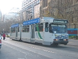
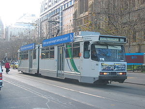
Operation
Route 1 is run from Brunswick depot and is predominantly run with Z3 classZ class Melbourne tram
The Z class are a single-unit, bogie tram that operates in Melbourne, Australia. They were built by Comeng, a manufacturing company in Dandenong, Victoria, Australia.-History:...
and B2 class
B class Melbourne tram
The B class are a two-section, three-bogie articulated tram that operates in Melbourne, Victoria. Following the introduction of two B1-class trams in 1984 and 1985, a total of 130 B2-class trams were ordered by the Victorian Government and built by Comeng in Dandenong, Victoria...
trams.