
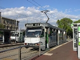
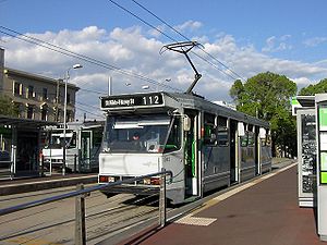
Melbourne tram route 112
Encyclopedia
Tram
route 112 is a public transport
service in Melbourne
, Victoria
, Australia
. It runs from West Preston
, in the northern suburb
s to St Kilda
.
Like most tram routes in Melbourne, it falls within Metcard
/myki
ticketing Zone 1.
Two variants of route 112 exist: route 11, which runs between West Preston and Victoria Harbour Docklands (via Collins Street), and the route 9, which runs between St Kilda and the Tram Depot in Thornbury (via Collins Street).
from Spencer Street to Fitzroy North, an electric line from Fitzroy North to West Preston and an electric line from the CBD
to Fitzroy Street, St Kilda (partially built utilising a former cable line).
A cable line was opened from Spencer Street to Barkly Street, Fitzroy North along Collins Street
, MacArthur Street, Gisborne Street, Victoria Parade, Brunswick Street and St Georges Road on the 2 October 1886, by the Melbourne Tramway and Omnibus Company.
The Fitzroy, Northcote and Preston Tramways Trust had started constructing a system but it wasn't until after its takeover by the Melbourne and Metropolitan Tramways Board that services first ran, on 1 April 1920, part of this system included a line from Barkly Street, Fitzroy North to Regent Street, Preston. This network was orphaned from the rest of the electric network until 24 March 1925 when a line along Holden Street, Pilkington Street and Barkly Street was built by the Melbourne and Metropolitan Tramways Board to allow access to the CBD via Lygon Street.
On 31 October 1925 a new route to St Kilda was opened by the Melbourne and Metropolitan Tramways Board, travelling from St Kilda Road along Sturt Street, Eastern Road, Heather Street, Park Street, Clarendon Street, Albert Road, Canterbury Road, Mills Street, Danks Street, Patterson Street, Park Street, Mary Street and Beaconsfield Parade.
In 1929 the Melbourne and Metropolitan Tramways Board started converting the Collins Street cable lines to electric traction, with the last cable tram running down Collins Street on 14 September 1929, and the first electric tram on 8 December 1929. At the same time the Melbourne and Metropolitan Tramways Board built a new electric line down the centre of Victoria Parade to replace the cable line, which opened on 15 September 1929. The remaining section of cable tram track along Brunswick Street and St Georges Road was converted to electric traction by the Melbourne and Metropolitan Tramways Board on 26 October 1930, connecting the West Preston electric line to Collins Street.
The South Melbourne cable line was converted to electric traction by the Melbourne and Metropolitan Tramways Board on 25 July 1937, with the section of track between Clarendon Street and Hannah Street (now Kings Way) along City Road abandoned in favour of a new section of track along Clarendon Street, between City Road and Flinders Street. This allowed trams to travel from St Kilda to Collins Street, along Clarendon Street and Spencer Street.
On 8 November 1959 the track along Mary St and Beaconsfield Parade, St Kilda West were abandoned in favour of a short extension along Park Street to Fitzroy Street, St Kilda, route 112's current terminus.
In 2005 route 112 was part of the Think>Tram
project, with measures aimed at improving tram services introduced to Clarendon Street, South Melbourne.
 Route 112 runs from West Preston
south on Gilbert Road, it turns east at Miller Street and south on St Georges Road, it then traverses the suburbs of Thornbury
, Northcote
and Fitzroy North
. At Edinburgh Gardens
it turns slightly into Brunswick Street
and continues south into Fitzroy
. Turns west into Victoria Parade and passes through St Vincent's Plaza, East Melbourne
, passing St Vincent's Hospital
, Eye and Ear Hospital and turns south onto Gisborne Street, continues south west along MacArthur Street and turns west into Collins Street
, entering the CBD
, passing Melbourne Town Hall
and City Square.
It turns south into Spencer Street
, passing Southern Cross Station, it crosses the Yarra River
and enters Southbank
on Clarendon Street where it traverses South Melbourne
, at Albert Road it turns south west, passing the Melbourne Sports and Aquatic Centre
, it turns south east briefly onto Canterbury Road, Albert Park
and turns south west into Mills Street, and finally south east into Danks Street, Middle Park
, Patterson Street and Park Street, to its terminus at Fitzroy Street, St Kilda
.
and is predominantly run with A class and B2 class
trams although D2 class occasionally run the route.
Tram
A tram is a passenger rail vehicle which runs on tracks along public urban streets and also sometimes on separate rights of way. It may also run between cities and/or towns , and/or partially grade separated even in the cities...
route 112 is a public transport
Public transport
Public transport is a shared passenger transportation service which is available for use by the general public, as distinct from modes such as taxicab, car pooling or hired buses which are not shared by strangers without private arrangement.Public transport modes include buses, trolleybuses, trams...
service in Melbourne
Melbourne
Melbourne is the capital and most populous city in the state of Victoria, and the second most populous city in Australia. The Melbourne City Centre is the hub of the greater metropolitan area and the Census statistical division—of which "Melbourne" is the common name. As of June 2009, the greater...
, Victoria
Victoria (Australia)
Victoria is the second most populous state in Australia. Geographically the smallest mainland state, Victoria is bordered by New South Wales, South Australia, and Tasmania on Boundary Islet to the north, west and south respectively....
, Australia
Australia
Australia , officially the Commonwealth of Australia, is a country in the Southern Hemisphere comprising the mainland of the Australian continent, the island of Tasmania, and numerous smaller islands in the Indian and Pacific Oceans. It is the world's sixth-largest country by total area...
. It runs from West Preston
Preston, Victoria
Preston is a suburb in Melbourne, Victoria, Australia, 9 km north from Melbourne's central business district. Its Local Government Area is the City of Darebin. At the 2006 Census, Preston had a population of 27,892.-Settlement:...
, in the northern suburb
Suburb
The word suburb mostly refers to a residential area, either existing as part of a city or as a separate residential community within commuting distance of a city . Some suburbs have a degree of administrative autonomy, and most have lower population density than inner city neighborhoods...
s to St Kilda
St Kilda, Victoria
St Kilda is an inner city suburb of Melbourne, Victoria, Australia, 6 km south from Melbourne's central business district. Its Local Government Area is the City of Port Phillip...
.
Like most tram routes in Melbourne, it falls within Metcard
Metcard
"OneLink" redirects here. For the computer/cable company, see OneLink Communications.Metcard is the brand name of an integrated ticketing system used to access public transport in Melbourne, Australia. It is a universal ticket which allows users to ride on the city's Metlink network, consisting of...
/myki
Myki
myki is the contactless smartcard ticketing system being introduced on public transport in Victoria, Australia. myki is designed to replace a number of ticket systems in Victoria, primarily the Metcard and V/Line ticketing systems...
ticketing Zone 1.
Two variants of route 112 exist: route 11, which runs between West Preston and Victoria Harbour Docklands (via Collins Street), and the route 9, which runs between St Kilda and the Tram Depot in Thornbury (via Collins Street).
History
The origins of route 112 lie in separate tram lines, a cable tramCable car (railway)
A cable car or cable railway is a mass transit system using rail cars that are hauled by a continuously moving cable running at a constant speed. Individual cars stop and start by releasing and gripping this cable as required...
from Spencer Street to Fitzroy North, an electric line from Fitzroy North to West Preston and an electric line from the CBD
Melbourne city centre
Melbourne City Centre is an area of Melbourne in Victoria, Australia. It is not to be confused with the larger local government area of the City of Melbourne...
to Fitzroy Street, St Kilda (partially built utilising a former cable line).
A cable line was opened from Spencer Street to Barkly Street, Fitzroy North along Collins Street
Collins Street, Melbourne
Collins Street is a major street in the Melbourne central business district and runs approximately east to west.It is notable as Melbourne's traditional main street and best known street, is often regarded as Australia's premier street, with some of the country's finest Victorian era buildings.The...
, MacArthur Street, Gisborne Street, Victoria Parade, Brunswick Street and St Georges Road on the 2 October 1886, by the Melbourne Tramway and Omnibus Company.
The Fitzroy, Northcote and Preston Tramways Trust had started constructing a system but it wasn't until after its takeover by the Melbourne and Metropolitan Tramways Board that services first ran, on 1 April 1920, part of this system included a line from Barkly Street, Fitzroy North to Regent Street, Preston. This network was orphaned from the rest of the electric network until 24 March 1925 when a line along Holden Street, Pilkington Street and Barkly Street was built by the Melbourne and Metropolitan Tramways Board to allow access to the CBD via Lygon Street.
On 31 October 1925 a new route to St Kilda was opened by the Melbourne and Metropolitan Tramways Board, travelling from St Kilda Road along Sturt Street, Eastern Road, Heather Street, Park Street, Clarendon Street, Albert Road, Canterbury Road, Mills Street, Danks Street, Patterson Street, Park Street, Mary Street and Beaconsfield Parade.
In 1929 the Melbourne and Metropolitan Tramways Board started converting the Collins Street cable lines to electric traction, with the last cable tram running down Collins Street on 14 September 1929, and the first electric tram on 8 December 1929. At the same time the Melbourne and Metropolitan Tramways Board built a new electric line down the centre of Victoria Parade to replace the cable line, which opened on 15 September 1929. The remaining section of cable tram track along Brunswick Street and St Georges Road was converted to electric traction by the Melbourne and Metropolitan Tramways Board on 26 October 1930, connecting the West Preston electric line to Collins Street.
The South Melbourne cable line was converted to electric traction by the Melbourne and Metropolitan Tramways Board on 25 July 1937, with the section of track between Clarendon Street and Hannah Street (now Kings Way) along City Road abandoned in favour of a new section of track along Clarendon Street, between City Road and Flinders Street. This allowed trams to travel from St Kilda to Collins Street, along Clarendon Street and Spencer Street.
On 8 November 1959 the track along Mary St and Beaconsfield Parade, St Kilda West were abandoned in favour of a short extension along Park Street to Fitzroy Street, St Kilda, route 112's current terminus.
In 2005 route 112 was part of the Think>Tram
Think Tram
Think Tram is a Victorian Government program aimed at improving Melbourne's tram network. The intended benefits are reduced travel time and better reliability, and better accessibility. The program is being run by VicRoads, in partnership with Yarra Trams and the Department of Infrastructure...
project, with measures aimed at improving tram services introduced to Clarendon Street, South Melbourne.
Route
Preston, Victoria
Preston is a suburb in Melbourne, Victoria, Australia, 9 km north from Melbourne's central business district. Its Local Government Area is the City of Darebin. At the 2006 Census, Preston had a population of 27,892.-Settlement:...
south on Gilbert Road, it turns east at Miller Street and south on St Georges Road, it then traverses the suburbs of Thornbury
Thornbury, Victoria
Thornbury originalSince the 1960s, the vast majority of Melburnians pronounce the name phonetically. The 'h' is no longer silent, and there is more stress placed upon the 'o'. pronunciation is a suburb in Melbourne, Victoria, Australia, 7 km north from Melbourne's central business district....
, Northcote
Northcote, Victoria
Northcote is a suburb in Melbourne, Victoria, Australia, 7 km north-east from Melbourne's central business district. Its Local Government Area is the City of Darebin...
and Fitzroy North
Fitzroy North, Victoria
Fitzroy North is a suburb in Melbourne, Victoria, Australia, 4 km north-east from Melbourne's central business district. Its Local Government Area are the Cities of Yarra and Moreland. At the 2006 Census, Fitzroy North had a population of 11,069....
. At Edinburgh Gardens
Edinburgh Gardens, Melbourne
Edinburgh Gardens is a large park located in North Fitzroy. It is bounded by Brunswick Street and St Georges Road to the west, the curve of Alfred Crescent to the north and east, and Freeman Street to the south. It was created from a grant of land in March 1862 by Queen Victoria and laid out by...
it turns slightly into Brunswick Street
Brunswick Street, Melbourne
Brunswick Street is a street in inner northern Melbourne, known for cafés, live music venues and alternative fashion shops.-Geography:Brunswick Street runs north-south through the inner northern Melbourne suburbs of Fitzroy and Fitzroy North, from Victoria Parade at its southernmost end, crossing...
and continues south into Fitzroy
Fitzroy, Victoria
Fitzroy is an inner city suburb of Melbourne, Victoria, Australia, 2 km north-east from Melbourne's central business district. Its Local Government Area is the City of Yarra. Its borders are Alexandra Parade , Victoria Parade , Smith Street and Nicholson Street. Fitzroy is Melbourne's...
. Turns west into Victoria Parade and passes through St Vincent's Plaza, East Melbourne
East Melbourne, Victoria
East Melbourne is a suburb in Melbourne, Victoria, Australia, adjacent to Melbourne's central business district. Its Local Government Area is the City of Melbourne. At the 2006 Census, East Melbourne had a population of 4,330....
, passing St Vincent's Hospital
St Vincent's Hospital, Melbourne
St Vincent's Hospital, Melbourne is the major hospital in Fitzroy, Melbourne, Australia.It is operated by the St Vincent's Health service, previously known as the Sisters of Charity Health Service, Melbourne...
, Eye and Ear Hospital and turns south onto Gisborne Street, continues south west along MacArthur Street and turns west into Collins Street
Collins Street, Melbourne
Collins Street is a major street in the Melbourne central business district and runs approximately east to west.It is notable as Melbourne's traditional main street and best known street, is often regarded as Australia's premier street, with some of the country's finest Victorian era buildings.The...
, entering the CBD
Melbourne city centre
Melbourne City Centre is an area of Melbourne in Victoria, Australia. It is not to be confused with the larger local government area of the City of Melbourne...
, passing Melbourne Town Hall
Melbourne Town Hall
Melbourne Town Hall is the central municipal building of the City of Melbourne, Australia, in the State of Victoria. It is located on the northeast corner of Swanston and Collins Streets, in the central business district. It is the seat of the Local Government Area of the City of Melbourne...
and City Square.
It turns south into Spencer Street
Spencer Street, Melbourne
Spencer Street is a major street in the central business district of Melbourne, Victoria, Australia. It is named for John Spencer, 3rd Earl Spencer, Chancellor of the Exchequer under Lord Melbourne, the Prime Minister of the United Kingdom....
, passing Southern Cross Station, it crosses the Yarra River
Yarra River
The Yarra River, originally Birrarung, is a river in east-central Victoria, Australia. The lower stretches of the river is where the city of Melbourne was established in 1835 and today Greater Melbourne dominates and influences the landscape of its lower reaches...
and enters Southbank
Southbank, Victoria
Southbank is an inner city suburb of Melbourne, Victoria, Australia located direct south of the Yarra River opposite Melbourne's Hoddle Grid. The northernmost area is considered part of the Central Business District and Central Activities District of the city. Its Local Government Area are the...
on Clarendon Street where it traverses South Melbourne
South Melbourne, Victoria
South Melbourne is an inner city suburb in Melbourne, Victoria, Australia, 2 km south from Melbourne's central business district. Its Local Government Area are the Cities of Port Phillip and Melbourne...
, at Albert Road it turns south west, passing the Melbourne Sports and Aquatic Centre
Melbourne Sports and Aquatic Centre
The Melbourne Sports and Aquatic Centre is an international sporting venue located in Albert Park, Victoria, Australia. The centre was opened on the 24th of July 1997 at a construction cost of A$65 million. The cost was funded by the State Government of Victoria and the City of Port Phillip...
, it turns south east briefly onto Canterbury Road, Albert Park
Albert Park, Victoria
Albert Park is an inner city suburb of Melbourne, Victoria, Australia, 3 km south from Melbourne's central business district. Its Local Government Area is the City of Port Phillip. At the 2006 Census, Albert Park had a population of 5827....
and turns south west into Mills Street, and finally south east into Danks Street, Middle Park
Middle Park, Victoria
Middle Park is a suburb in Melbourne, Victoria, Australia, 5 km south from Melbourne's central business district. Its Local Government Area is the City of Port Phillip. At the 2006 Census, Middle Park had a population of 4012...
, Patterson Street and Park Street, to its terminus at Fitzroy Street, St Kilda
St Kilda, Victoria
St Kilda is an inner city suburb of Melbourne, Victoria, Australia, 6 km south from Melbourne's central business district. Its Local Government Area is the City of Port Phillip...
.
Operation
Route 112 is run from East Preston depot and Southbank depotSouthbank Tram Depot
Southbank Tram Depot is located in Southbank, a suburb of Melbourne in Victoria, Australia. It is one of 8 depots operated in the Yarra Trams network. The depot was opened in March 1997 on the site of the former Montague shipping shed, and replaced the now-demolished South Melbourne tram depot.-...
and is predominantly run with A class and B2 class
B class Melbourne tram
The B class are a two-section, three-bogie articulated tram that operates in Melbourne, Victoria. Following the introduction of two B1-class trams in 1984 and 1985, a total of 130 B2-class trams were ordered by the Victorian Government and built by Comeng in Dandenong, Victoria...
trams although D2 class occasionally run the route.