

Ten Mile, Tennessee
Encyclopedia
Unincorporated area
In law, an unincorporated area is a region of land that is not a part of any municipality.To "incorporate" in this context means to form a municipal corporation, a city, town, or village with its own government. An unincorporated community is usually not subject to or taxed by a municipal government...
in northern Meigs
Meigs County, Tennessee
Meigs County is a county located in the U.S. state of Tennessee. As of 2010, the population was 11,753. Its county seat is Decatur.-History:Before 1819, the area that is now Meigs County was Cherokee territory. White settlers established ferries to cross the Tennessee River from Rhea County as...
and southeastern Roane counties in the U.S. state
U.S. state
A U.S. state is any one of the 50 federated states of the United States of America that share sovereignty with the federal government. Because of this shared sovereignty, an American is a citizen both of the federal entity and of his or her state of domicile. Four states use the official title of...
of Tennessee
Tennessee
Tennessee is a U.S. state located in the Southeastern United States. It has a population of 6,346,105, making it the nation's 17th-largest state by population, and covers , making it the 36th-largest by total land area...
. The Roane County portion is included in the Harriman, Tennessee
Harriman, Tennessee
Harriman is a city in the U.S. state of Tennessee, primarily in Roane County, with a small extension into Morgan County. It is the principal city of and is included in the Harriman Micropolitan Statistical Area, which consists of Roane County and is a component of the Knoxville-Sevierville-La...
Micropolitan Statistical Area.
Ten Mile is primarily a summer cottage community on Watts Bar Lake
Watts Bar Lake
Watts Bar Lake is a reservoir on the Tennessee River created by Watts Bar Dam as part of the Tennessee Valley Authority system.-Geography:Located about midway between Chattanooga and Knoxville, the lake begins as the Tennessee River below Fort Loudon Dam in Lenoir City, Tennessee and stretches...
. It includes summer cottages, small locally owned stores and restaurants, a bank, marinas, resorts, churches, and a Post Office (ZIP code
ZIP Code
ZIP codes are a system of postal codes used by the United States Postal Service since 1963. The term ZIP, an acronym for Zone Improvement Plan, is properly written in capital letters and was chosen to suggest that the mail travels more efficiently, and therefore more quickly, when senders use the...
37880). The nearby TVA
Tennessee Valley Authority
The Tennessee Valley Authority is a federally owned corporation in the United States created by congressional charter in May 1933 to provide navigation, flood control, electricity generation, fertilizer manufacturing, and economic development in the Tennessee Valley, a region particularly affected...
Watts Bar nuclear plant
Watts Bar Nuclear Generating Station
The Watts Bar Nuclear Generating Station is a Tennessee Valley Authority nuclear reactor used for electric power generation and tritium production for nuclear weapons. It is located on a 1,770-acre site in Rhea County, Tennessee, near Spring City, between the cities of Chattanooga and Knoxville...
(in bordering Rhea County
Rhea County, Tennessee
Rhea County is a county located in the U.S. state of Tennessee. As of 2000, the population was 28,400. Its county seat is Dayton.-Geography:According to the U.S...
), and Watts Bar Dam
Watts Bar Dam
Watts Bar Dam is a hydroelectric dam on the Tennessee River in Meigs County and Rhea County, Tennessee, USA. The dam is one of nine dams on the main Tennessee River channel operated by the Tennessee Valley Authority, which built the dam in early 1940s to provide flood control and electricity and...
spanning the Tennessee River
Tennessee River
The Tennessee River is the largest tributary of the Ohio River. It is approximately 652 miles long and is located in the southeastern United States in the Tennessee Valley. The river was once popularly known as the Cherokee River, among other names...
across the Meigs County and Rhea County lines have played, and continue to play, an important role in the local economy.
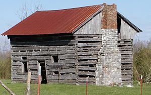
Historic house
The Elisha Sharp HouseElisha Sharp House
The Elisha Sharp House is a house in Ten Mile, Tennessee. It was added to the National Register of Historic Places on July 6, 1982.Elisha Sharp was born July 25, 1792, and died December 6, 1863. In 1817, he married Elinore Ellen Huff . She was sixteen years old, and he was twenty five...
in Ten Mile, Tennessee was added to the National Register of Historic Places
National Register of Historic Places
The National Register of Historic Places is the United States government's official list of districts, sites, buildings, structures, and objects deemed worthy of preservation...
on July 6, 1982.
External links
- Why do they call it that? Ten Mile community in Meigs and Roane Counties, WBIR-TV website.