
McLeod River
Encyclopedia
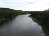
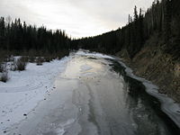
Mcleod River is a significant river in west-central Alberta
, Canada
. It forms in the foothills of the Canadian Rockies
, and is a major tributary of the Athabasca River
.
, at the confluence of Thornton and Cheviot Creeks. These creeks are fed by the meltwater on the western slopes of Tripoli and Cheviot Mountains. The Mcleod River then follows the Grave Flats Road, taking on Prospect, Whitehorse
, and Cadomin Creeks before emptying into Lac des Roches, south of the town of Cadomin.
The river then snakes through the foothills, and is soon joined by four major tributaries, the Gregg
, Erith, Embarras
, and Edson
rivers before meeting the Athabasca River near the town of Whitecourt, Alberta.
watershed to the North
and South Saskatchewan
Rivers. In 1970, a preliminary engineering report on the McLeod Valley Dam was released by the provincial Department of Agriculture.
The dam
was to be located 20 miles (32.2 km) northeast of Edson, Alberta
, near the hamlet
of Peers, Alberta
. The diverted water would have been sent via a canal
to Chip Lake
. The report read:
The McLeod Valley Dam, as well as the larger Athabasca-to-Saskatchewan
diversion scheme, was shelved in the 1970s due to rising construction costs and environmental concerns.
Alberta
Alberta is a province of Canada. It had an estimated population of 3.7 million in 2010 making it the most populous of Canada's three prairie provinces...
, Canada
Canada
Canada is a North American country consisting of ten provinces and three territories. Located in the northern part of the continent, it extends from the Atlantic Ocean in the east to the Pacific Ocean in the west, and northward into the Arctic Ocean...
. It forms in the foothills of the Canadian Rockies
Canadian Rockies
The Canadian Rockies comprise the Canadian segment of the North American Rocky Mountains range. They are the eastern part of the Canadian Cordillera, extending from the Interior Plains of Alberta to the Rocky Mountain Trench of British Columbia. The southern end borders Idaho and Montana of the USA...
, and is a major tributary of the Athabasca River
Athabasca River
The Athabasca River originates from the Columbia Glacier of the Columbia Icefield in Jasper National Park in Alberta, Canada...
.
Course
The river begins just outside the eastern border of Jasper National ParkJasper National Park
Jasper National Park is the largest national park in the Canadian Rockies, spanning 10,878 km² . It is located in the province of Alberta, north of Banff National Park and west of the City of Edmonton. The park includes the glaciers of the Columbia Icefield, hot springs, lakes, waterfalls and...
, at the confluence of Thornton and Cheviot Creeks. These creeks are fed by the meltwater on the western slopes of Tripoli and Cheviot Mountains. The Mcleod River then follows the Grave Flats Road, taking on Prospect, Whitehorse
Whitehorse Creek
Whitehorse Creek is a significant stream in western Alberta, Canada. It flows from the Canadian Rockies, and is the first major tributary of the Mcleod River, a major tributary of the Athabasca River....
, and Cadomin Creeks before emptying into Lac des Roches, south of the town of Cadomin.
The river then snakes through the foothills, and is soon joined by four major tributaries, the Gregg
Gregg River
The Gregg River is a short river in west-central Alberta. The river is named after Mr. John James Gregg . John Gregg was a prospector and trapper prominent in the area. -Course:...
, Erith, Embarras
Embarras River (Alberta)
The Embarras River is a short river in west-central Alberta, Canada. The river likely derived its name from the French word for obstruction, because it is often obstructed by driftwood. -Course:...
, and Edson
Edson River
The Edson River is a minor river in west-central Alberta, Canada. The river, like the nearby town of Edson, is named for Edson Joseph Chamberlin , a Vice-President and General Manager of the Grand Trunk Pacific Railway...
rivers before meeting the Athabasca River near the town of Whitecourt, Alberta.
Planned Dam
Throughout the 1950s and the 1960s the Alberta Government undertook a number of planning studies that discussed diverting water from the Athabasca-MackenzieMackenzie River
The Mackenzie River is the largest river system in Canada. It flows through a vast, isolated region of forest and tundra entirely within the country's Northwest Territories, although its many tributaries reach into four other Canadian provinces and territories...
watershed to the North
North Saskatchewan River
The North Saskatchewan River is a glacier-fed river that flows east from the Canadian Rockies to central Saskatchewan. It is one of two major rivers that join to make up the Saskatchewan River....
and South Saskatchewan
South Saskatchewan River
The South Saskatchewan River is a major river in Canada that flows through the provinces of Alberta and Saskatchewan....
Rivers. In 1970, a preliminary engineering report on the McLeod Valley Dam was released by the provincial Department of Agriculture.
The dam
Dam
A dam is a barrier that impounds water or underground streams. Dams generally serve the primary purpose of retaining water, while other structures such as floodgates or levees are used to manage or prevent water flow into specific land regions. Hydropower and pumped-storage hydroelectricity are...
was to be located 20 miles (32.2 km) northeast of Edson, Alberta
Edson, Alberta
Edson is a town in west-central Alberta, Canada. It is located in Yellowhead County, west of Edmonton along the Yellowhead Highway and east of the intersection with Highway 47.- History :left|thumb|200px|Welcome Sign...
, near the hamlet
Hamlet (place)
A hamlet is usually a rural settlement which is too small to be considered a village, though sometimes the word is used for a different sort of community. Historically, when a hamlet became large enough to justify building a church, it was then classified as a village...
of Peers, Alberta
Peers, Alberta
Peers is a hamlet in west-central Alberta, Canada within Yellowhead County. It is located on Highway 32, north of the Yellowhead Highway and approximately northeast of Edson.Statistics Canada recognizes Peers as a designated place....
. The diverted water would have been sent via a canal
Canal
Canals are man-made channels for water. There are two types of canal:#Waterways: navigable transportation canals used for carrying ships and boats shipping goods and conveying people, further subdivided into two kinds:...
to Chip Lake
Chip Lake
Chip Lake is a large lake in west-central Alberta. The Lobstick River flows through the lake. It in turn is a tributary of the Pembina River, which eventually flows into the Athabasca River....
. The report read:
- "The main embankmentEmbankment damAn embankment dam is a massive artificial water barrier. It is typically created by the emplacement and compaction of a complex semi-plastic mound of various compositions of soil, sand, clay and/or rock. It has a semi-permanent waterproof natural covering for its surface, and a dense, waterproof...
would be 5810 feet long with crest elevation at 2780 feet and a maximum height of 140 feet. Dykes, 13,230 feet long and with a maximum height of 15 feet would also be required. Two diversion tunnels, one of which will later be converted to a low level outlet, are proposed to handle river flow during the construction period. A gated ogee crest spillwaySpillwayA spillway is a structure used to provide the controlled release of flows from a dam or levee into a downstream area, typically being the river that was dammed. In the UK they may be known as overflow channels. Spillways release floods so that the water does not overtop and damage or even destroy...
has been designed with a discharge capacity sufficient to route a 1:500 year floodFloodA flood is an overflow of an expanse of water that submerges land. The EU Floods directive defines a flood as a temporary covering by water of land not normally covered by water...
through the reservoirReservoirA reservoir , artificial lake or dam is used to store water.Reservoirs may be created in river valleys by the construction of a dam or may be built by excavation in the ground or by conventional construction techniques such as brickwork or cast concrete.The term reservoir may also be used to...
. The dam would create a reservoir approximately 12 miles long with a total storage area of 562700 acre.ft at full supply level of 2770 feet."
The McLeod Valley Dam, as well as the larger Athabasca-to-Saskatchewan
Saskatchewan River
The Saskatchewan River is a major river in Canada, approximately long, flowing roughly eastward across Saskatchewan and Manitoba to empty into Lake Winnipeg...
diversion scheme, was shelved in the 1970s due to rising construction costs and environmental concerns.
Tributaries
Tributaries of the McLeod River, from headwaters to the Athabasca River, include:- Thornton Creek
- Cheviot Creek
- Prospect Creek
- Whitehorse CreekWhitehorse CreekWhitehorse Creek is a significant stream in western Alberta, Canada. It flows from the Canadian Rockies, and is the first major tributary of the Mcleod River, a major tributary of the Athabasca River....
- Drummond Creek, Harlequin Creek
- Cadomin Creek
- Luscar Creek
- Lac des Roches
- Watson Creek
- Mackenzie Creek
- Beaverdam Creek
- Taylor Creek, Chief Creek, Thompson Creek, Rainbow Creek
- Mercoal Creek
- Deerlick Creek
- Eunice Creek
- Wampus Creek
- Mary Gregg Creek
- Mary Gregg Lake, Trapper Creek
- Antler Creek
- McCardell Creek
- Gregg RiverGregg RiverThe Gregg River is a short river in west-central Alberta. The river is named after Mr. John James Gregg . John Gregg was a prospector and trapper prominent in the area. -Course:...
- Berry's Creek, Sphinx Creek, Drinnan Creek, Folding Mountain Creek, Mystery Lake, Warden Creek, Teepee Creek, Wigwam Creek
- Anderson Creek
- Quigley Creek
- McPherson Creek
- White Creek
- Corral Creek
- Embarras RiverEmbarras River (Alberta)The Embarras River is a short river in west-central Alberta, Canada. The river likely derived its name from the French word for obstruction, because it is often obstructed by driftwood. -Course:...
- Mitchell Creek, Baril Creek, Lambert Creek, Neill Creek, Prest Creek, Bryan Creek, Dummy (Hay) Creek
- Erith River
- Rodney Creek, Raven Creek, Hanlan Creek, Lendrum Creek, Lund Creek, Halpenny Creek, Wickham Creek
- Little Sundance Creek
- Swartz Creek
- Wolf Creek
- Edson RiverEdson RiverThe Edson River is a minor river in west-central Alberta, Canada. The river, like the nearby town of Edson, is named for Edson Joseph Chamberlin , a Vice-President and General Manager of the Grand Trunk Pacific Railway...
- Bench Creek
- Trout Creek
- January Creek
- South Carrot Creek
- Lost Creek
- Groat Creek
- Beaver Creek