
.gif)
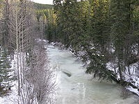
Embarras River (Alberta)
Encyclopedia
River
A river is a natural watercourse, usually freshwater, flowing towards an ocean, a lake, a sea, or another river. In a few cases, a river simply flows into the ground or dries up completely before reaching another body of water. Small rivers may also be called by several other names, including...
in west-central Alberta
Alberta
Alberta is a province of Canada. It had an estimated population of 3.7 million in 2010 making it the most populous of Canada's three prairie provinces...
, Canada
Canada
Canada is a North American country consisting of ten provinces and three territories. Located in the northern part of the continent, it extends from the Atlantic Ocean in the east to the Pacific Ocean in the west, and northward into the Arctic Ocean...
. The river
River
A river is a natural watercourse, usually freshwater, flowing towards an ocean, a lake, a sea, or another river. In a few cases, a river simply flows into the ground or dries up completely before reaching another body of water. Small rivers may also be called by several other names, including...
likely derived its name from the French word for obstruction, because it is often obstructed by driftwood.
Course
It flows north-northeast through the Rocky Mountain foothils before being joined by the Erith river. It then flows into the McLeod RiverMcLeod River
Mcleod River is a significant river in west-central Alberta, Canada. It forms in the foothills of the Canadian Rockies, and is a major tributary of the Athabasca River.-Course:...
, which in turn flows into the Athabasca River
Athabasca River
The Athabasca River originates from the Columbia Glacier of the Columbia Icefield in Jasper National Park in Alberta, Canada...
.
The Embarrass forms near Robb, Alberta
Robb, Alberta
Robb is a hamlet in west-central Alberta, Canada within Yellowhead County. It is located on Highway 47, approximately southwest of Edson. It has an elevation of .Statistics Canada recognizes Robb as a designated place....
at the junction of a few small creeks. Snaking northward, the Embarrass parallels Alberta Highway 47 before its confluence with the McLeod.
Embarrass Landing is a former coal town established at the confluence of the river with Prest Creek. In the winter, it freezes solid. In the summer, it can reach speeds of 35 mph.
Tributaries
- Dummy (Hay) Creek
- Prest Creek
- Neill Creek
- Mitchell Creek
- Baril Creek
- Lambert Creek