

Mayflower Steps, Plymouth
Encyclopedia
Barbican, Plymouth
The Barbican is the name now given to the western and northern sides of the old harbour area of Plymouth, Devon, England. It was one of the few parts of the city to escape most of the destruction of The Blitz during the Second World War...
area of Plymouth
Plymouth
Plymouth is a city and unitary authority area on the coast of Devon, England, about south-west of London. It is built between the mouths of the rivers Plym to the east and Tamar to the west, where they join Plymouth Sound...
, south-west England
England
England is a country that is part of the United Kingdom. It shares land borders with Scotland to the north and Wales to the west; the Irish Sea is to the north west, the Celtic Sea to the south west, with the North Sea to the east and the English Channel to the south separating it from continental...
, from which the Pilgrim Fathers are believed to have finally left England aboard the Mayflower
Mayflower
The Mayflower was the ship that transported the English Separatists, better known as the Pilgrims, from a site near the Mayflower Steps in Plymouth, England, to Plymouth, Massachusetts, , in 1620...
, before crossing the Atlantic Ocean
Atlantic Ocean
The Atlantic Ocean is the second-largest of the world's oceanic divisions. With a total area of about , it covers approximately 20% of the Earth's surface and about 26% of its water surface area...
to settle in North America
North America
North America is a continent wholly within the Northern Hemisphere and almost wholly within the Western Hemisphere. It is also considered a northern subcontinent of the Americas...
on 6 September 1620. The traditional site of their disembarkation in North America is Plymouth Rock
Plymouth Rock
Plymouth Rock is the traditional site of disembarkation of William Bradford and the Mayflower Pilgrims who founded Plymouth Colony in 1620. It is an important symbol in American history...
.
The passengers who came predominantly from East Anglia
East Anglia
East Anglia is a traditional name for a region of eastern England, named after an ancient Anglo-Saxon kingdom, the Kingdom of the East Angles. The Angles took their name from their homeland Angeln, in northern Germany. East Anglia initially consisted of Norfolk and Suffolk, but upon the marriage of...
sought religious and other freedoms. They had no links with Plymouth, but because of bad weather in the English Channel
English Channel
The English Channel , often referred to simply as the Channel, is an arm of the Atlantic Ocean that separates southern England from northern France, and joins the North Sea to the Atlantic. It is about long and varies in width from at its widest to in the Strait of Dover...
they were forced to put in at Plymouth seeking shelter and essential repairs. Several surviving local buildings including what is now the Plymouth Gin Distillery
Plymouth Gin Distillery
The Plymouth Gin Distillery in The Barbican, Plymouth, England has been in operation since 1793 and used to be a significant manufacturer of gin in the UK. Also known as the Black Friars Distillery, it is the only gin distillery in the city....
in Southside Street and the Island House on the Quay are claimed to have accommodated some of them for one or more nights.
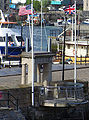
The 'Steps' today consist of a commemorative portico with Doric columns of Portland stone that was built in 1934, and a small platform over the water with a brushed steel rail and a shelf with some nautical bronze artwork and historical information. It is on a small pier that was built about a century ago when some very old houses that were blocking construction of a road around the seaward side of the Citadel
Royal Citadel, Plymouth
The Royal Citadel in Plymouth, Devon, England, was built in the late 1660s to the design of Sir Bernard de Gomme. It is at the eastern end of Plymouth Hoe overlooking Plymouth Sound, and encompasses the site of the earlier fort that had been built in the time of Sir Francis Drake.During the Dutch...
leading to the Hoe
Plymouth Hoe
Plymouth Hoe, referred to locally as the Hoe, is a large south facing open public space in the English coastal city of Plymouth. The Hoe is adjacent to and above the low limestone cliffs that form the seafront and it commands views of Plymouth Sound, Drake's Island, and across the Hamoaze to Mount...
were cleared together with the significant Watch House. Today, boat trips leave the Mayflower Steps for trips around the Sound
Plymouth Sound
Plymouth Sound, or locally just The Sound, is a bay at Plymouth in England.Its southwest and southeast corners are Penlee Point in Cornwall and Wembury Point on Devon, a distance of about 3 nautical miles . Its northern limit is Plymouth Hoe giving a north-south distance of nearly 3 nautical miles...
and up the Tamar
River Tamar
The Tamar is a river in South West England, that forms most of the border between Devon and Cornwall . It is one of several British rivers whose ancient name is assumed to be derived from a prehistoric river word apparently meaning "dark flowing" and which it shares with the River Thames.The...
for sight of the 'Dockyard and Warships'
HMNB Devonport
Her Majesty's Naval Base Devonport , is one of three operating bases in the United Kingdom for the Royal Navy . HMNB Devonport is located in Devonport, in the west of the city of Plymouth in Devon, England...
.
The best effort by local historians to place the actual site of the Mayflower finally casting off is roughly where a Victorian public house, the Admiral MacBride, now stands.