
Maryland Route 49
Encyclopedia
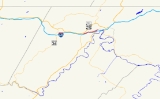
Maryland Route 49 is a state highway
in the U.S. state
of Maryland
. Known as Braddock Road, the state highway runs 2.7 miles (4.3 km) from MD 658
in La Vale
east to Greene Street in Cumberland
. MD 49 is maintained by the Maryland State Highway Administration
(MDSHA) for 1.02 miles (1.6 km) on the west side of Haystack Mountain
. The 1.7 miles (2.7 km) eastern segment, maintained by the city of Cumberland, is not recognized as part of the state highway by MDSHA but is signed as MD 49. Braddock Road was cleared as a military trail in the 1750s and was part of the National Road
in the early 19th century. The modern MD 49 was constructed in the 1920s. The state highway originally extended west to MD 53
just south of U.S. Route 40
(US 40), but the highway was physically truncated by the construction of Interstate 68
(I-68) in the early 1970s. The eastern part of MD 49 was transferred to Cumberland in the early 1990s.
MD 49 remains level until the descent of Haystack Mountain starts just before the intersection with Seton Drive, which leads to Bishop Walsh School
and the site of Sacred Heart Hospital
, which closed in 2009. The south leg of the intersection is an exit ramp from Exit 41 of westbound I-68. East of Seton Drive, MD 49 enters another residential area. At the bottom of the hill, the highway meets its eastern terminus at a five-way intersection, known as The Dingle, with north–south Fayette Street and Greene Street, the old alignment of US 220
that the highway meets at an oblique angle.
in 1755 as part of his unsuccessful campaign to capture Fort Duquesne
. The Braddock Road was repurposed in 1811 as the original route of the National Road
over Haystack Mountain. The National Road was moved to the longer but less steep route through the Cumberland Narrows
in 1833. The Braddock Road was considered to have begun at its intersection with Greene Street, a junction that became known as The Dingle, named for a residential neighborhood bounded by Greene Street and Braddock Road originally built as a gated community for Celanese
executives starting in 1913.
Modern MD 49 was paved from Greene Street to Seton Drive in 1923 and from there to La Vale by 1930. The state highway originally continued west from its present terminus to an intersection with MD 53 just south of MD 53's intersection with US 40. MD 49 was rolled back to its present western terminus in 1972 concurrent with the construction of I-68, which cut off two segments of the original alignment. Those two sections are now parts of MD 949. MD 49 was removed from state maintenance between Greene Street and Seton Drive around 1989. The section between Seton Drive and Sunset Drive was returned to local maintenance around 1993, concurrent with the expansion of Cumberland city limits in the area.
.
{| class=wikitable
!Location
!Mile
!Destinations
!Notes
|-
|rowspan=2|La Vale
|0.00
|
|Western terminus; west leg of intersection is Exit 40 ramp from I-68 west
|-
|1.02
|Sunset Drive
|Official eastern terminus according to MDSHA
|-
|rowspan=2|Cumberland
|1.7
|Seton Drive north
|South leg of intersection is Exit 41 ramp from I-68 west
|-
|2.7
|Greene Street / Fayette Street
|Signed eastern terminus; Greene Street is old alignment of US 220
State highway
State highway, state road or state route can refer to one of three related concepts, two of them related to a state or provincial government in a country that is divided into states or provinces :#A...
in the U.S. state
U.S. state
A U.S. state is any one of the 50 federated states of the United States of America that share sovereignty with the federal government. Because of this shared sovereignty, an American is a citizen both of the federal entity and of his or her state of domicile. Four states use the official title of...
of Maryland
Maryland
Maryland is a U.S. state located in the Mid Atlantic region of the United States, bordering Virginia, West Virginia, and the District of Columbia to its south and west; Pennsylvania to its north; and Delaware to its east...
. Known as Braddock Road, the state highway runs 2.7 miles (4.3 km) from MD 658
Maryland Route 658
Maryland Route 658 is an unsigned state highway in the U.S. state of Maryland. The state highway runs from MD 53 north to U.S. Route 40 Alternate within La Vale...
in La Vale
La Vale, Maryland
La Vale is a census-designated place in Allegany County, Maryland, United States. It is part of the 'Cumberland, MD-WV Metropolitan Statistical Area'...
east to Greene Street in Cumberland
Cumberland, Maryland
Cumberland is a city in the far western, Appalachian portion of Maryland, United States. It is the county seat of Allegany County, and the primary city of the Cumberland, MD-WV Metropolitan Statistical Area. At the 2010 census, the city had a population of 20,859, and the metropolitan area had a...
. MD 49 is maintained by the Maryland State Highway Administration
Maryland State Highway Administration
The Maryland State Highway Administration is the state agency responsible for maintaining Maryland numbered highways outside of Baltimore City...
(MDSHA) for 1.02 miles (1.6 km) on the west side of Haystack Mountain
Haystack Mountain (Maryland)
Haystack Mountain is a mountain ridge in the Ridge and Valley region of the Appalachian Mountains, located in western Maryland just west of the city of Cumberland...
. The 1.7 miles (2.7 km) eastern segment, maintained by the city of Cumberland, is not recognized as part of the state highway by MDSHA but is signed as MD 49. Braddock Road was cleared as a military trail in the 1750s and was part of the National Road
National Road
The National Road or Cumberland Road was the first major improved highway in the United States to be built by the federal government. Construction began heading west in 1811 at Cumberland, Maryland, on the Potomac River. It crossed the Allegheny Mountains and southwestern Pennsylvania, reaching...
in the early 19th century. The modern MD 49 was constructed in the 1920s. The state highway originally extended west to MD 53
Maryland Route 53
Maryland Route 53 is a state highway in the U.S. state of Maryland. Known as Winchester Road, the state highway runs from U.S. Route 220 in Cresaptown north to US 40 Alternate in La Vale...
just south of U.S. Route 40
U.S. Route 40 in Maryland
U.S. Route 40 in the U.S. state of Maryland runs from western Maryland to Cecil County in the state's northeastern corner. With a total length of over , it is the longest numbered highway in Maryland. Almost half of the road overlaps with Interstate 68 or Interstate 70, while the old alignment...
(US 40), but the highway was physically truncated by the construction of Interstate 68
Interstate 68
Interstate 68 is a Interstate highway in the U.S. states of West Virginia and Maryland, connecting in Morgantown to in Hancock. is also Corridor E of the Appalachian Development Highway System. From 1965 until the freeway's construction was completed in 1991, it was designated as...
(I-68) in the early 1970s. The eastern part of MD 49 was transferred to Cumberland in the early 1990s.
Route description
MD 49 begins as the east leg of an intersection with MD 658 (Vocke Road/Campground Road) in La Vale. Vocke Road, the south leg of the intersection, leads to an entrance ramp to I-68 east. Campground Road, the north leg, leads to an entrance ramp to I-68 west via US 40 Alternate. The west leg of the intersection is an exit ramp from Exit 40 of westbound I-68. MD 49 heads east as a two-lane road through a residential area, then enters a forested area and begins to ascend Haystack Mountain. The state highway officially ends at Sunset Drive just before the top of the climb, where the highway enters the city of Cumberland. However, the highway continues to be signed as MD 49.MD 49 remains level until the descent of Haystack Mountain starts just before the intersection with Seton Drive, which leads to Bishop Walsh School
Bishop Walsh School
Bishop Walsh School is a K-12 Catholic school located in Cumberland, Maryland, and under the jurisdiction of the Archdiocese of Baltimore. Approximately 600 students attend. The school also hosts a pre-K program and operates the St...
and the site of Sacred Heart Hospital
Sacred Heart Hospital (Cumberland)
WMHS Braddock Campus, located at 900 Seton Drive, was a hospital that served the Greater Cumberland, Maryland region in the USA.- History :First incorporated as Allegany Hospital in 1905, the Daughters of Charity were asked to come to Cumberland to operate the hospital in 1911. The hospital was...
, which closed in 2009. The south leg of the intersection is an exit ramp from Exit 41 of westbound I-68. East of Seton Drive, MD 49 enters another residential area. At the bottom of the hill, the highway meets its eastern terminus at a five-way intersection, known as The Dingle, with north–south Fayette Street and Greene Street, the old alignment of US 220
U.S. Route 220 in Maryland
U.S. Route 220 is a part in the U.S. Highway System that runs from Rockingham, North Carolina to Waverly, New York. In Maryland, the federal highway runs from the West Virginia state line at the Potomac River in McCoole north to the Pennsylvania state line in Dickens...
that the highway meets at an oblique angle.
History
Braddock Road is the modern descendant of the original military trail cleared by the forces of Edward BraddockEdward Braddock
General Edward Braddock was a British soldier and commander-in-chief for the 13 colonies during the actions at the start of the French and Indian War...
in 1755 as part of his unsuccessful campaign to capture Fort Duquesne
Fort Duquesne
Fort Duquesne was a fort established by the French in 1754, at the junction of the Allegheny and Monongahela rivers in what is now downtown Pittsburgh in the state of Pennsylvania....
. The Braddock Road was repurposed in 1811 as the original route of the National Road
National Road
The National Road or Cumberland Road was the first major improved highway in the United States to be built by the federal government. Construction began heading west in 1811 at Cumberland, Maryland, on the Potomac River. It crossed the Allegheny Mountains and southwestern Pennsylvania, reaching...
over Haystack Mountain. The National Road was moved to the longer but less steep route through the Cumberland Narrows
Cumberland Narrows
The Cumberland Narrows is a water gap in western Maryland in the United States, just west of Cumberland, Maryland. Wills Creek cuts through the central ridge of the Wills Mountain Anticline at a low elevation here between Wills Mountain to the north and Haystack Mountain to the south...
in 1833. The Braddock Road was considered to have begun at its intersection with Greene Street, a junction that became known as The Dingle, named for a residential neighborhood bounded by Greene Street and Braddock Road originally built as a gated community for Celanese
Celanese
Celanese Corporation is a Fortune 500 global technology and specialty materials company with its headquarters in Dallas, Texas. The company is a leading producer of acetyl products, which are intermediate chemicals for nearly all major industries, and is the world's largest producer of vinyl...
executives starting in 1913.
Modern MD 49 was paved from Greene Street to Seton Drive in 1923 and from there to La Vale by 1930. The state highway originally continued west from its present terminus to an intersection with MD 53 just south of MD 53's intersection with US 40. MD 49 was rolled back to its present western terminus in 1972 concurrent with the construction of I-68, which cut off two segments of the original alignment. Those two sections are now parts of MD 949. MD 49 was removed from state maintenance between Greene Street and Seton Drive around 1989. The section between Seton Drive and Sunset Drive was returned to local maintenance around 1993, concurrent with the expansion of Cumberland city limits in the area.
Junction list
The entire route is in Allegany CountyAllegany County, Maryland
Allegany County is a county located in the northwestern part of the US state of Maryland. It is part of the Cumberland, MD-WV Metropolitan Statistical Area. As of 2010, the population was 75,087. Its county seat is Cumberland...
.
{| class=wikitable
!Location
!Mile
!Destinations
!Notes
|-
|rowspan=2|La Vale
La Vale, Maryland
La Vale is a census-designated place in Allegany County, Maryland, United States. It is part of the 'Cumberland, MD-WV Metropolitan Statistical Area'...
|0.00
|
|Western terminus; west leg of intersection is Exit 40 ramp from I-68 west
|-
|1.02
|Sunset Drive
|Official eastern terminus according to MDSHA
Maryland State Highway Administration
The Maryland State Highway Administration is the state agency responsible for maintaining Maryland numbered highways outside of Baltimore City...
|-
|rowspan=2|Cumberland
Cumberland, Maryland
Cumberland is a city in the far western, Appalachian portion of Maryland, United States. It is the county seat of Allegany County, and the primary city of the Cumberland, MD-WV Metropolitan Statistical Area. At the 2010 census, the city had a population of 20,859, and the metropolitan area had a...
|1.7
|Seton Drive north
|South leg of intersection is Exit 41 ramp from I-68 west
|-
|2.7
|Greene Street / Fayette Street
|Signed eastern terminus; Greene Street is old alignment of US 220