
Maryland Route 117
Encyclopedia
Maryland Route 117 is the one of three highways connecting the major Washington, D.C.
suburbs of Gaithersburg
and Germantown (the other two being Interstate 270
and Maryland Route 355
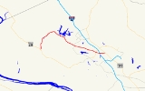
). Its 12.67 miles (20.4 km) span consists of three roads: West Diamond Avenue at the easternmost section, Clopper Road for the majority of Route 117's length as it moves into Gaithersburg and into Boyds, then Bucklodge Road from Boyds to its termination at Maryland Route 28
.
near Darnestown
, where it heads north on two-lane Bucklodge Road through open fields and woodland. It turns to the northeast, and once it passes the Brunswick Line
of the MARC Train
, it intersects Barnesville Road, taking its name as it turns southeast. At Boyds
, the route intersects MD 121, turning south for a very short stretch to pass under the Brunswick Line once again. It then turns east, paralleling the railroad for a short while on Clopper Road and heads into Germantown where MD 117 is a two-lane and four-lane divided road at various points.
MD 117 continues east and enters Clopper, where it intersects Maryland Route 124
. The road's name then becomes West Diamond Avenue, a four-lane divided road on either side of its interchange with Interstate 270
, where it squeezes to three lanes to fit underneath the freeway. It then continues for another short stretch to an interchange with Maryland Route 355
(consisting of a spur of MD 117 called 117A), where the road continues as Old Towne Avenue. At Fulks Corner Avenue, the MD 117 designation ends and municipal maintenance begins; Fulks Corner provides access to MD 355. Old Towne Avenue, however, continues for a very short stretch more to Summit Avenue.
Points of interest along MD 117 include Old Town Gaithersburg at its eastern end, the National Institute of Standards and Technology
near Route 124, Seneca Creek State Park
near the Germantown/Gaithersburg border, Little Seneca Regional Park near the Germantown/Boyds border, and the ruins of Clopper's Mill, located near the intersection of Waring Station Rd. and Clopper Rd., at this location: googlemap
The Germantown/Boyds section west of Maryland Route 119
to Bucklodge Road was largely farmland until the early 1990s, when the rapid development of Germantown began to replace much of the farmland with new home communities. Much of the western five miles (8 km) remains undeveloped.
This road is also the inspiration for the song "Take Me Home, Country Roads
" by John Denver
.
.
Washington, D.C.
Washington, D.C., formally the District of Columbia and commonly referred to as Washington, "the District", or simply D.C., is the capital of the United States. On July 16, 1790, the United States Congress approved the creation of a permanent national capital as permitted by the U.S. Constitution....
suburbs of Gaithersburg
Gaithersburg, Maryland
Gaithersburg is a city in Montgomery County, Maryland, United States. The city had a population of 59,933 at the 2010 census, making it the fourth largest incorporated city in the state, behind Baltimore, Frederick, and Rockville...
and Germantown (the other two being Interstate 270
Interstate 270 (Maryland)
Interstate 270 is a auxiliary Interstate Highway in the U.S. state of Maryland that travels between Interstate 495 just north of Bethesda, Montgomery County and Interstate 70 in the city of Frederick in Frederick County. It consists of the mainline as well as a spur that provides access to and...
and Maryland Route 355
Maryland Route 355
Maryland Route 355 is a north–south road in western central Maryland in the United States. The southern terminus of the route is at the Washington, D.C. border in Friendship Heights, Montgomery County, where it continues south as Wisconsin Avenue into Washington. The northern terminus is...
). Its 12.67 miles (20.4 km) span consists of three roads: West Diamond Avenue at the easternmost section, Clopper Road for the majority of Route 117's length as it moves into Gaithersburg and into Boyds, then Bucklodge Road from Boyds to its termination at Maryland Route 28
Maryland Route 28
Maryland Route 28 is a state highway in the U.S. state of Maryland. The state highway runs from U.S. Route 15 in Point of Rocks east to MD 182 in Norwood. The western portion of MD 28 is a rural highway connecting several villages in southern Frederick County and western Montgomery County...
.
Route description
Maryland Route 117 begins at Route 28 in BoydsBoyds, Maryland
Boyds, Maryland is an unincorporated community in rural Montgomery County, Maryland, located north of Washington, DC. Its ZIP Code is 20841.According to the United States 2000 Census, the ZIP Code Tabulation Area for the town of Boyds covers an area of and has a population of 2,025...
near Darnestown
Darnestown, Maryland
Darnestown is a census-designated place and an unincorporated area in Montgomery County, Maryland, United States.-Geography:As an unincorporated area, Darnestown's boundaries are not officially defined...
, where it heads north on two-lane Bucklodge Road through open fields and woodland. It turns to the northeast, and once it passes the Brunswick Line
Brunswick Line
The Brunswick Line is a MARC commuter rail line consisting of a main line running from Washington D.C. to Martinsburg, West Virginia and a branch line from just south of Point-of-Rocks station to Frederick, Maryland. The service is operated under contract by CSX Transportation, but is administered...
of the MARC Train
MARC Train
MARC , known prior to 1984 as Maryland Rail Commuter Service, is a regional rail system comprising three lines in the Baltimore-Washington Metropolitan Area. MARC is administered by the Maryland Transit Administration , a Maryland Department of Transportation agency, and is operated under contract...
, it intersects Barnesville Road, taking its name as it turns southeast. At Boyds
Boyds, Maryland
Boyds, Maryland is an unincorporated community in rural Montgomery County, Maryland, located north of Washington, DC. Its ZIP Code is 20841.According to the United States 2000 Census, the ZIP Code Tabulation Area for the town of Boyds covers an area of and has a population of 2,025...
, the route intersects MD 121, turning south for a very short stretch to pass under the Brunswick Line once again. It then turns east, paralleling the railroad for a short while on Clopper Road and heads into Germantown where MD 117 is a two-lane and four-lane divided road at various points.
MD 117 continues east and enters Clopper, where it intersects Maryland Route 124
Maryland Route 124
Maryland Route 124 is a mixed suburban and semi-rural road that runs through several suburbs and exurbs to the north of Washington, DC in Montgomery County, Maryland. It changes names several times over its length, beginning as Quince Orchard Road near Darnestown and terminating as Woodfield Road...
. The road's name then becomes West Diamond Avenue, a four-lane divided road on either side of its interchange with Interstate 270
Interstate 270 (Maryland)
Interstate 270 is a auxiliary Interstate Highway in the U.S. state of Maryland that travels between Interstate 495 just north of Bethesda, Montgomery County and Interstate 70 in the city of Frederick in Frederick County. It consists of the mainline as well as a spur that provides access to and...
, where it squeezes to three lanes to fit underneath the freeway. It then continues for another short stretch to an interchange with Maryland Route 355
Maryland Route 355
Maryland Route 355 is a north–south road in western central Maryland in the United States. The southern terminus of the route is at the Washington, D.C. border in Friendship Heights, Montgomery County, where it continues south as Wisconsin Avenue into Washington. The northern terminus is...
(consisting of a spur of MD 117 called 117A), where the road continues as Old Towne Avenue. At Fulks Corner Avenue, the MD 117 designation ends and municipal maintenance begins; Fulks Corner provides access to MD 355. Old Towne Avenue, however, continues for a very short stretch more to Summit Avenue.
Points of interest along MD 117 include Old Town Gaithersburg at its eastern end, the National Institute of Standards and Technology
National Institute of Standards and Technology
The National Institute of Standards and Technology , known between 1901 and 1988 as the National Bureau of Standards , is a measurement standards laboratory, otherwise known as a National Metrological Institute , which is a non-regulatory agency of the United States Department of Commerce...
near Route 124, Seneca Creek State Park
Seneca Creek State Park
Seneca Creek State Park encompasses approximately 6,300 acres in Montgomery County, Maryland, USA, and extends along 14 miles of Seneca Creek to the Potomac River.-Clopper Lake Day Use Area:...
near the Germantown/Gaithersburg border, Little Seneca Regional Park near the Germantown/Boyds border, and the ruins of Clopper's Mill, located near the intersection of Waring Station Rd. and Clopper Rd., at this location: googlemap
The Germantown/Boyds section west of Maryland Route 119
Maryland Route 119
Maryland Route 119, also known as Great Seneca Highway, is a north–south Maryland state highway that runs from Maryland Route 28 in Rockville to Middlebrook Road in Germantown.-Route description:...
to Bucklodge Road was largely farmland until the early 1990s, when the rapid development of Germantown began to replace much of the farmland with new home communities. Much of the western five miles (8 km) remains undeveloped.
This road is also the inspiration for the song "Take Me Home, Country Roads
Take Me Home, Country Roads
"Take Me Home, Country Roads" is a song written by John Denver, Taffy Nivert, and Bill Danoff and initially recorded by John Denver. It was included on his 1971 breakout album Poems, Prayers and Promises; the single went to #2 on the U.S. Billboard Hot 100...
" by John Denver
John Denver
Henry John Deutschendorf, Jr. , known professionally as John Denver, was an American singer/songwriter, activist, and humanitarian. After growing up in numerous locations with his military family, Denver began his music career in folk music groups in the late 1960s. His greatest commercial success...
.
Junction list
The entire route is in Montgomery CountyMontgomery County, Maryland
Montgomery County is a county in the U.S. state of Maryland, situated just to the north of Washington, D.C., and southwest of the city of Baltimore. It is one of the most affluent counties in the United States, and has the highest percentage of residents over 25 years of age who hold post-graduate...
.
| Location | Mile |
Roads intersected | Notes |
|---|---|---|---|
| Dawsonville | 0.00 | Western terminus | |
| Boyds Boyds, Maryland Boyds, Maryland is an unincorporated community in rural Montgomery County, Maryland, located north of Washington, DC. Its ZIP Code is 20841.According to the United States 2000 Census, the ZIP Code Tabulation Area for the town of Boyds covers an area of and has a population of 2,025... |
5.23 | ||
| Germantown | 7.57 | ||
| 8.06 | |||
| Gaithersburg Gaithersburg, Maryland Gaithersburg is a city in Montgomery County, Maryland, United States. The city had a population of 59,933 at the 2010 census, making it the fourth largest incorporated city in the state, behind Baltimore, Frederick, and Rockville... |
11.26 | ||
| 11.45 | Bureau Drive | Entrance to NIST National Institute of Standards and Technology The National Institute of Standards and Technology , known between 1901 and 1988 as the National Bureau of Standards , is a measurement standards laboratory, otherwise known as a National Metrological Institute , which is a non-regulatory agency of the United States Department of Commerce... |
|
| 11.75 | – Washington Washington, D.C. Washington, D.C., formally the District of Columbia and commonly referred to as Washington, "the District", or simply D.C., is the capital of the United States. On July 16, 1790, the United States Congress approved the creation of a permanent national capital as permitted by the U.S. Constitution.... |
I-270 exit 10 | |
| 12.52 | |||
| 12.71 | Fulks Corner Avenue | Eastern terminus |