
Maryland Route 119
Encyclopedia
Maryland Route 119, also known as Great Seneca Highway, is a north–south Maryland
state highway
that runs from Maryland Route 28
in Rockville
to Middlebrook Road in Germantown.
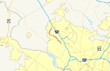
on the four-lane divided Great Seneca Highway. It winds to the northwest, passing through a wooded suburban residential area and eventually passing by a large shopping center as it intersects MD 124. Beyond this intersection, MD 119 enters a stretch of forest and curves to the north, emerging from said forest after crossing a transmission line. Nearing Germantown, the residential areas pick up once again, and the route curves a bit more before it crosses a creek and finds its northern terminus at Middlebrook Road near a high school.
.
Maryland
Maryland is a U.S. state located in the Mid Atlantic region of the United States, bordering Virginia, West Virginia, and the District of Columbia to its south and west; Pennsylvania to its north; and Delaware to its east...
state highway
State highway
State highway, state road or state route can refer to one of three related concepts, two of them related to a state or provincial government in a country that is divided into states or provinces :#A...
that runs from Maryland Route 28
Maryland Route 28
Maryland Route 28 is a state highway in the U.S. state of Maryland. The state highway runs from U.S. Route 15 in Point of Rocks east to MD 182 in Norwood. The western portion of MD 28 is a rural highway connecting several villages in southern Frederick County and western Montgomery County...
in Rockville
Rockville, Maryland
Rockville is the county seat of Montgomery County, Maryland, United States. It is a major incorporated city in the central part of Montgomery County and forms part of the Baltimore-Washington Metropolitan Area. The 2010 U.S...
to Middlebrook Road in Germantown.
Route description
Maryland Route 119 begins at a wide intersection at MD 28 (Key West Avenue), beginning in RockvilleRockville, Maryland
Rockville is the county seat of Montgomery County, Maryland, United States. It is a major incorporated city in the central part of Montgomery County and forms part of the Baltimore-Washington Metropolitan Area. The 2010 U.S...
on the four-lane divided Great Seneca Highway. It winds to the northwest, passing through a wooded suburban residential area and eventually passing by a large shopping center as it intersects MD 124. Beyond this intersection, MD 119 enters a stretch of forest and curves to the north, emerging from said forest after crossing a transmission line. Nearing Germantown, the residential areas pick up once again, and the route curves a bit more before it crosses a creek and finds its northern terminus at Middlebrook Road near a high school.
Junction list
The entire route is in Montgomery CountyMontgomery County, Maryland
Montgomery County is a county in the U.S. state of Maryland, situated just to the north of Washington, D.C., and southwest of the city of Baltimore. It is one of the most affluent counties in the United States, and has the highest percentage of residents over 25 years of age who hold post-graduate...
.
| Location | Mile |
Roads intersected | Notes |
|---|---|---|---|
| Rockville | 0.00 | Southern terminus | |
| Gaithersburg Gaithersburg, Maryland Gaithersburg is a city in Montgomery County, Maryland, United States. The city had a population of 59,933 at the 2010 census, making it the fourth largest incorporated city in the state, behind Baltimore, Frederick, and Rockville... |
2.57 | ||
| Germantown | 6.04 | ||
| 7.47 | Middlebrook Road | Northern terminus |