

Marabá
Encyclopedia
Maraba is a city in the state of Pará
, Brazil
. The reference location is the meeting point between two great rivers, forming a sort of "y" in the city as seen from above. It basically consists of five urban centers, linked by three highways.
It is the fourth most populous city in the state of Para, approximately 233,462 inhabitants according to the IBGE
/2010, and the third largest GDP in the state of Pará, with 3115485.000, the main center of political, social and economic development of southern and southeastern Para and one of the most dynamic cities in Brazil.
Maraba has a strategic position, is crossed by five major highway. He also has a large logistics infrastructure, with port, airport and railway. The city has a growing industrial park, especially the steel industry, is important in agriculture, with a vast agricultural frontier, and also has a strong trade and services sector.
Maraba is characterized by its wide mix of peoples and cultures that does justice to the meaning of its popular name of "son of the mix." The city is also known as the City Poem, because his name was inspired by a poem by poet Gonçalves Dias.
A poem written by Gonçalves Dias inspired Francisco Silva, who named his store of goodwill, situated at the confluence of the Tocantins/Itacaiúnas. The store actually a big shed, served the pioneers of all types of dry and wet. There, according to tradition, Cole bought the rubber collected, Andiroba, Copaiba
, wild fruits, and several fighters, funds held in a lively cabaret, with the sale of drinks and women who himself had come from far eastern Amazon.
in the sixteenth century, remained without a permanent occupation for nearly 300 years. Only since 1892 is that, in fact, the space was occupied by settlers. The first to participate in the formation of the town of Maraba in 1892 were political leaders who had escaped from the guerrillas staged at the north of Goias
, specifically the city of Boa Vista. The pioneer Carlos Gomes Leitão, accompanied by his family and aides work shifted to the southeast of Pará, establishing their first camp in a locality situated on land bordered by the confluence of the Tocantins and Itacaiúnas. Settling in the end, after a year of observations on the left bank of the Tocantins, about 10 km downstream from the other camp, which he called on local Burgh. The point where they settled began to give way in the woods in search of natural fields that would serve to cattle. In one of these raids, one of its workers struck a tree in some casual shooting until then unknown, whose shot made it abundantly pour into a milky liquid that, some time after touching the ground, clotted spontaneously.
In 1894, the following immigrant Goias
to the provincial capital to have a meeting with then president of the province of Grand Para, José Paes de Carvalho, who requested the cooperation, since the need to colonize the southern province, having been awarded 6 with tales of kings in cash and stock of drugs that would be used particularly in combating malaria
and other tropical diseases. Succeeded in their attempt to help and for having the tests of the milk plant hardened proven that it was legitimate rubber, Leitão, back to the Burgh, broadcasted the information to all of the little colony. The following year began to arrive the first wave of staff for the extraction of rubber. The dealer and Maranhense
Francisco Coelho da Silva would have been the first to establish themselves in the area between the rivers Tocantins and Itacaiúnas. The goal was to negotiate with the miners of Caucho, who through the mouth of the river Itacaiúnas, sailed up the Tocantins River
. The records give the name of Francisco Silva city. He would have installed on the local trading house Maraba, whose name was a tribute to poet Gonçalves Dias.
, Ceará
, Piauí
, Goiás
, Paraíba
, Maranhão
, but also Palestinians and Lebanese immigrants, constituting an important layer in the local society. In 1929, the city is already illuminated by a wood burning power plant and 17 November 1935 the first plane lands at the airport recently opened in town. During this period the city was composed of 450 houses and 1500 inhabitants fixed.
and deployment of the Grande Carajás project, the discovery of gold mine of Serra Pelada, streamlined and accelerated migration to Maraba decades 1970 and 1980. In 1970, the city was declared a National Security Area, a condition that lasted until the end of military dictatorship in 1985. Besides the region is strategic to the integration policy, it was the region to fight the Araguaia Guerrilla (movement inspired by the Chinese Communist action), resulting in an overt presence of the troops of the Brazilian Army, the city was one of the bases of operations for troops Federal. Also in 1970 the NIP (National Integration Program), which, among other measures, provided for the construction of the Trans-Amazon Highway, whose first section was opened in 1971, along with the creation of a post at the National Institute of Colonization and Agrarian Reform (INCRA) in Maraba.
, a deal that has brought great benefits and growth for the city.
On April 5, 1990 is promulgated the Organic Law of the municipality of Maraba. The district population increased significantly during the 90's, and in mid-1998 the number reached 157,884 inhabitants fixed in the next year, the city itself as the headquarters of major events with national impact. During the administration of then Mayor Geraldo Veloso the council went through a rapid process of structural modernization, and economic policy, highlighting the significant growth experienced. In consequence of these reforms the council during the years 2002 to 2008, received a massive investment, which has culminated in the city became a center metal and mechanical industry. Currently the population Marabá is around 203,049 inhabitants, according to official estimates, this estimate and growth is inevitable, since the city is in the process of accelerated development and receives many people from other localities.
. Since the late nineteenth century (1892) until the late 40s, was marked by the extraction of the rubber boom
that has contributed greatly to the economy of the city and the region, however, the rubber crisis led the council to a new cycle . This time, the cycle of Brazil nuts, which for years led the municipal economy. There was also the cycle of diamonds between 1920 and 1940, which were mainly found on the river Tocantins. With the discovery of Serra Pelada
and be in the world's largest mineral, Maraba also experienced the cycle of the mines, which had the greatest emphasis, the extraction of gold.
Since the early 70's the city began to experience the installation of the Grande Carajás project, and later steel industries, rather than boosted the local economy.
The fishing sector also has a key role in local economic base by exporting its surplus for the entire north and northeast. Agriculture is diversified, with production cereals, pulses and oilseeds such as corn, rice and beans, fruits such as bananas and acai, and logging
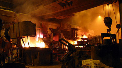 Through the Industrial Development Company of Para - CDI, was installed at the end of the eighties, in an area of 1,300 hectares, the industrial district of Maraba - DIM, to create the base of a steel pole targeting the Carajas iron ore, exploited by the mining company Vale.
Metallurgical Industries and intense livestock activity, accounted for a large environmental devastation in the region. The activity of the steel industry requires large amounts of coal, leading to a devastation of native forests. As a result of public pressure the industries were forced to change its production model, investing in reforestation and charcoal production through the babassu coconut palm.
Besides, to have more than 200 industries, and the steel (pig iron) most important, second is the timber industry and the manufacture of tiles and bricks. The city's economy also relies on the production of manganese and Agribusiness
. In Maraba, Agribusiness works with pulp processing, cassava
flour, rice processing, milk and palm.
The installation of steel plant came boost the local economy even more, forming a metal pole-mechanical, with a view to verticalize the local mineral production. There are still projects that seen during and after the installation of steel works, among them: The gas pipeline Açailândia-Maraba and construction of new port city.
. The city is increasingly gaining representation in hosting numerous public institutions. The trade of the city is highlighted, because the city is a major regional commercial hub of South and Southeast of Pará.
Marabá is served by Marabá Airport
.
Beach Tucunaré (Peacock Bass)
One of the best options during the summer of Pará, the Beach Peacock Bass
is the most visited tourist spot in town. Emerging from the ebb of the Tocantins River
, just after the rainy season the beach occupies an area of approximately 5 km ², of which three quarters are of fine sand and one quarter of vegetation. Situated opposite the central region of Maraba, the sands of the island are sighted in mid-April, but their high season is in July, making it the main attraction of the city.
The beach provides vacationers, practice water sports and sandy, camping, fishing, and various attractions promoted by the Municipality.
Along the beach is prepared a lot of vendors that offer visitors a multitude of dishes and drinks, including the Coconut Beach, the peacock bass fry
Beach geladinho
Located opposite the district of San Felix, also appears in the summer with the decrease in the level of the river Tocantins. Its natural beauty won a special touch with the vision of Rail/Road bridge over the river Tocantins, to transport the ore extracted from the Serra dos Carajás.
Church of St. Felix of Valois
It was the first chapel built in Maraba. It was made by Francis Acacio, in the 20s in honor of Santa Maria. The first building was destroyed by the flooding of rivers in 1926, then another church was erected on the same site. It is the first historical heritage of the city, officially recognized on April 5, 1993. The church is located in Piazza San Felix, in the central city
Palace Augusto Dias
Seat of the Legislature was built in the 30s to serve the City and the Forum
Municipal Museum of Maraba
The Municipal Museum is installed at the Foundation House of Culture of Maraba and includes the following sectors: Division of Anthropology
, Department of Botany
, Department of Geology
, Department of Archaeology
and Department of Zoology
. In addition to host school of Music, the municipal public archives, the Museum makes several studies on the region southeast of Pará, rescuing and preserving local history. The museum has the support and guidance of the Goeldi Museum
, in relation to the training of technicians and identification of the material through an agreement with the institution. The Municipal Museum of Maraba is one of Brazil's most respected institutions in the framework of research, rescue, environmental and historical preservation.
, the city's principal football club won the state championship
in 2010 and reached the Copa do Brasil
semi-finals in 2009. In 2010, it placed 3nd on the National Championship's Serie C.
Pará
Pará is a state in the north of Brazil. It borders the Brazilian states of Amapá, Maranhão, Tocantins, Mato Grosso, Amazonas and Roraima. To the northwest it also borders Guyana and Suriname, and to the northeast it borders the Atlantic Ocean. The capital is Belém.Pará is the most populous state...
, Brazil
Brazil
Brazil , officially the Federative Republic of Brazil , is the largest country in South America. It is the world's fifth largest country, both by geographical area and by population with over 192 million people...
. The reference location is the meeting point between two great rivers, forming a sort of "y" in the city as seen from above. It basically consists of five urban centers, linked by three highways.
It is the fourth most populous city in the state of Para, approximately 233,462 inhabitants according to the IBGE
IBGE
The Brazilian Institute of Geography and Statistics or IBGE , is the agency responsible for statistical, geographic, cartographic, geodetic and environmental information in Brazil...
/2010, and the third largest GDP in the state of Pará, with 3115485.000, the main center of political, social and economic development of southern and southeastern Para and one of the most dynamic cities in Brazil.
Maraba has a strategic position, is crossed by five major highway. He also has a large logistics infrastructure, with port, airport and railway. The city has a growing industrial park, especially the steel industry, is important in agriculture, with a vast agricultural frontier, and also has a strong trade and services sector.
Maraba is characterized by its wide mix of peoples and cultures that does justice to the meaning of its popular name of "son of the mix." The city is also known as the City Poem, because his name was inspired by a poem by poet Gonçalves Dias.
Etymology
The etymology of the word "Maraba" is an indigenous term - like many others that we know by name rivers, towns, cities and relieves the state of Pará - and means son of the prisoner or abroad or even India's fruit with white.A poem written by Gonçalves Dias inspired Francisco Silva, who named his store of goodwill, situated at the confluence of the Tocantins/Itacaiúnas. The store actually a big shed, served the pioneers of all types of dry and wet. There, according to tradition, Cole bought the rubber collected, Andiroba, Copaiba
Copaiba
Copaiba is a stimulant oleoresin obtained from the trunk of several pinnate-leaved South American leguminous trees . The thick, transparent exudate varies in color from light gold to dark brown, depending on the ratio of resin to essential oil...
, wild fruits, and several fighters, funds held in a lively cabaret, with the sale of drinks and women who himself had come from far eastern Amazon.
Colonization
The settlement of the basin Itacaiúnas plays in shaping the city an important role, because even though this region has been further explored by the PortuguesePortugal
Portugal , officially the Portuguese Republic is a country situated in southwestern Europe on the Iberian Peninsula. Portugal is the westernmost country of Europe, and is bordered by the Atlantic Ocean to the West and South and by Spain to the North and East. The Atlantic archipelagos of the...
in the sixteenth century, remained without a permanent occupation for nearly 300 years. Only since 1892 is that, in fact, the space was occupied by settlers. The first to participate in the formation of the town of Maraba in 1892 were political leaders who had escaped from the guerrillas staged at the north of Goias
Goiás
Goiás is a state of Brazil, located in the central part of the country. The name Goiás comes from the name of an indigenous community...
, specifically the city of Boa Vista. The pioneer Carlos Gomes Leitão, accompanied by his family and aides work shifted to the southeast of Pará, establishing their first camp in a locality situated on land bordered by the confluence of the Tocantins and Itacaiúnas. Settling in the end, after a year of observations on the left bank of the Tocantins, about 10 km downstream from the other camp, which he called on local Burgh. The point where they settled began to give way in the woods in search of natural fields that would serve to cattle. In one of these raids, one of its workers struck a tree in some casual shooting until then unknown, whose shot made it abundantly pour into a milky liquid that, some time after touching the ground, clotted spontaneously.
In 1894, the following immigrant Goias
Goiás
Goiás is a state of Brazil, located in the central part of the country. The name Goiás comes from the name of an indigenous community...
to the provincial capital to have a meeting with then president of the province of Grand Para, José Paes de Carvalho, who requested the cooperation, since the need to colonize the southern province, having been awarded 6 with tales of kings in cash and stock of drugs that would be used particularly in combating malaria
Malaria
Malaria is a mosquito-borne infectious disease of humans and other animals caused by eukaryotic protists of the genus Plasmodium. The disease results from the multiplication of Plasmodium parasites within red blood cells, causing symptoms that typically include fever and headache, in severe cases...
and other tropical diseases. Succeeded in their attempt to help and for having the tests of the milk plant hardened proven that it was legitimate rubber, Leitão, back to the Burgh, broadcasted the information to all of the little colony. The following year began to arrive the first wave of staff for the extraction of rubber. The dealer and Maranhense
Maranhão
Maranhão is a northeastern state of Brazil. To the north lies the Atlantic Ocean. Maranhão is neighbored by the states of Piauí, Tocantins and Pará. The people of Maranhão have a distinctive accent...
Francisco Coelho da Silva would have been the first to establish themselves in the area between the rivers Tocantins and Itacaiúnas. The goal was to negotiate with the miners of Caucho, who through the mouth of the river Itacaiúnas, sailed up the Tocantins River
Tocantins River
The Tocantins is a river in Brazil, the central fluvial artery of the country. In the Tupi language, its name means "toucan's beak" . It runs from south to north for about 2,640 km. It is not really a branch of the Amazon River, although usually so considered, since its waters flow into the...
. The records give the name of Francisco Silva city. He would have installed on the local trading house Maraba, whose name was a tribute to poet Gonçalves Dias.
Emancipation Hall
This commercial hub, where the "Itacaiúnas flowing in Tocantins, pressing a strip of land shaped peninsula," came the city of Maraba. So in tribute to its founder, the official name of the neighborhood popularly known as "Dry hair is Francisco Coelho. Created February 27, 1913 by claim Marabá community, the municipality was not formally installed on 5 April of that year, that date is now celebrated as his birthday and only received the title of city on October 27, 1923. The first Mayor Hall, at the time corresponding to the position of mayor, was Colonel Antonio da Rocha Maia, selected and appointed on the date of installation ceremonies. The fronts of migration into the region of Maraba, from the mid-20s, aimed especially the extraction and sale of Brazil nuts, and since the late '30s, in diamond mining in the Tocantins River stones. The city received immigrants from various regions of Brazil, especially BahiaBahia
Bahia is one of the 26 states of Brazil, and is located in the northeastern part of the country on the Atlantic coast. It is the fourth most populous Brazilian state after São Paulo, Minas Gerais and Rio de Janeiro, and the fifth-largest in size...
, Ceará
Ceará
Ceará is one of the 27 states of Brazil, located in the northeastern part of the country, on the Atlantic coast. It is currently the 8th largest Brazilian State by population and the 17th by area. It is also one of the main touristic destinations in Brazil. The state capital is the city of...
, Piauí
Piauí
Piauí is one of the states of Brazil, located in the northeastern part of the country.Piauí has the shortest coastline of any of the non-landlocked Brazilian states at 66 km , and the capital, Teresina, is the only state capital in the north east to be located inland...
, Goiás
Goiás
Goiás is a state of Brazil, located in the central part of the country. The name Goiás comes from the name of an indigenous community...
, Paraíba
Paraíba
Paraíba Paraíba Paraíba (Tupi: pa'ra a'íba: "bad to navigation"; Brazilian Portuguese pronunciation: is a state of Brazil. It is located in the Brazilian Northeast, and is bordered by Rio Grande do Norte to the north, Ceará to the west, Pernambuco to the south and the Atlantic Ocean to the east...
, Maranhão
Maranhão
Maranhão is a northeastern state of Brazil. To the north lies the Atlantic Ocean. Maranhão is neighbored by the states of Piauí, Tocantins and Pará. The people of Maranhão have a distinctive accent...
, but also Palestinians and Lebanese immigrants, constituting an important layer in the local society. In 1929, the city is already illuminated by a wood burning power plant and 17 November 1935 the first plane lands at the airport recently opened in town. During this period the city was composed of 450 houses and 1500 inhabitants fixed.
The 1970s
With the opening of Route PA-70, in 1969, Maraba is linked to the Belém-Brasília Highway. The implementation of road infrastructure was part of the strategy the federal government (Military Regime in Brazil) to integrate the region with the rest of the country. Besides the official plan of agricultural colonization, the establishment of construction sites, especially the construction of a hydroelectric plant in TucuruíTucuruí
Tucuruí is a town and municipality in the state of Pará in the Northern region of Brazil.The city is served by Tucuruí Airport.-References:...
and deployment of the Grande Carajás project, the discovery of gold mine of Serra Pelada, streamlined and accelerated migration to Maraba decades 1970 and 1980. In 1970, the city was declared a National Security Area, a condition that lasted until the end of military dictatorship in 1985. Besides the region is strategic to the integration policy, it was the region to fight the Araguaia Guerrilla (movement inspired by the Chinese Communist action), resulting in an overt presence of the troops of the Brazilian Army, the city was one of the bases of operations for troops Federal. Also in 1970 the NIP (National Integration Program), which, among other measures, provided for the construction of the Trans-Amazon Highway, whose first section was opened in 1971, along with the creation of a post at the National Institute of Colonization and Agrarian Reform (INCRA) in Maraba.
Recent facts
In 1980 the city is plagued by the greatest flood in its history, the Tocantins River rises 17.42 meters. As a result there is a redesign of urban growth and city expansion. In 1984, comes into operation the Carajas Railroad, in 1988 and start the preparations for the installation of steel industries, for production of pig ironPig iron
Pig iron is the intermediate product of smelting iron ore with a high-carbon fuel such as coke, usually with limestone as a flux. Charcoal and anthracite have also been used as fuel...
, a deal that has brought great benefits and growth for the city.
On April 5, 1990 is promulgated the Organic Law of the municipality of Maraba. The district population increased significantly during the 90's, and in mid-1998 the number reached 157,884 inhabitants fixed in the next year, the city itself as the headquarters of major events with national impact. During the administration of then Mayor Geraldo Veloso the council went through a rapid process of structural modernization, and economic policy, highlighting the significant growth experienced. In consequence of these reforms the council during the years 2002 to 2008, received a massive investment, which has culminated in the city became a center metal and mechanical industry. Currently the population Marabá is around 203,049 inhabitants, according to official estimates, this estimate and growth is inevitable, since the city is in the process of accelerated development and receives many people from other localities.
Economy
The municipality of Maraba experienced various economic cycles. Until the early 80's economy was based on the extraction plant. At first revolved around the extraction of latex rubber, whose lucrative attracted large numbers of the NortheastNortheast Region, Brazil
The Northeast Region of Brazil is composed of the following states: Maranhão, Piauí, Ceará, Rio Grande do Norte, Paraíba, Pernambuco, Alagoas, Sergipe and Bahia, and it represents 18.26% of the Brazilian territory....
. Since the late nineteenth century (1892) until the late 40s, was marked by the extraction of the rubber boom
Rubber boom
The rubber boom was an important part of the economic and social history of Brazil and Amazonian regions of neighboring countries, being related with the extraction and commercialization of rubber...
that has contributed greatly to the economy of the city and the region, however, the rubber crisis led the council to a new cycle . This time, the cycle of Brazil nuts, which for years led the municipal economy. There was also the cycle of diamonds between 1920 and 1940, which were mainly found on the river Tocantins. With the discovery of Serra Pelada
Serra Pelada
Serra Pelada was a large gold mine in Brazil south of the mouth of the Amazon River. The mine was made famous by the images taken by Sebastião Salgado showing an anthill of workers moving vast amounts of ore by hand...
and be in the world's largest mineral, Maraba also experienced the cycle of the mines, which had the greatest emphasis, the extraction of gold.
Since the early 70's the city began to experience the installation of the Grande Carajás project, and later steel industries, rather than boosted the local economy.
Primary sector
Today, Maraba is the economic center and a vast administrative region of the Amazon agricultural frontier ", the city has one of the most significant economic growth in the country. Livestock based on cattle ranching is an activity of great importance for the municipality, and ensure the livelihoods of the population, provides the regional and local development by creating large scale, and is marketed in different Brazilian regions and abroad. The herd area is highlighted by its superior quality, being one of the most important cattle herds of the state, a result arising from the use of advanced technology in the selection and fertilization. It has also herds of pigs, horses, sheep and poultryThe fishing sector also has a key role in local economic base by exporting its surplus for the entire north and northeast. Agriculture is diversified, with production cereals, pulses and oilseeds such as corn, rice and beans, fruits such as bananas and acai, and logging
Secondary sector
Metallurgical Industries and intense livestock activity, accounted for a large environmental devastation in the region. The activity of the steel industry requires large amounts of coal, leading to a devastation of native forests. As a result of public pressure the industries were forced to change its production model, investing in reforestation and charcoal production through the babassu coconut palm.
Besides, to have more than 200 industries, and the steel (pig iron) most important, second is the timber industry and the manufacture of tiles and bricks. The city's economy also relies on the production of manganese and Agribusiness
Agribusiness
In agriculture, agribusiness is a generic term for the various businesses involved in food production, including farming and contract farming, seed supply, agrichemicals, farm machinery, wholesale and distribution, processing, marketing, and retail sales....
. In Maraba, Agribusiness works with pulp processing, cassava
Cassava
Cassava , also called yuca or manioc, a woody shrub of the Euphorbiaceae native to South America, is extensively cultivated as an annual crop in tropical and subtropical regions for its edible starchy tuberous root, a major source of carbohydrates...
flour, rice processing, milk and palm.
The installation of steel plant came boost the local economy even more, forming a metal pole-mechanical, with a view to verticalize the local mineral production. There are still projects that seen during and after the installation of steel works, among them: The gas pipeline Açailândia-Maraba and construction of new port city.
Tertiary sector
The trade and services sector also has its share of contribution. Maraba has approximately 5 000 outlets divided between trade formed by micro, small, medium and large businesses and services, Hospital, Financial, Education, Construction and Public Utilities. It is a very powerful and comes with high rates of growth. This is because the strategy of state government, to decentralize services from the state capital, BelémBelém
Belém is a Brazilian city, the capital and largest city of state of Pará, in the country's north region. It is the entrance gate to the Amazon with a busy port, airport and bus/coach station...
. The city is increasingly gaining representation in hosting numerous public institutions. The trade of the city is highlighted, because the city is a major regional commercial hub of South and Southeast of Pará.
Marabá is served by Marabá Airport
Marabá Airport
Marabá Airport is the airport serving Marabá, Brazil.It is operated by Infraero.-Airlines and destinations:-Accidents and incidents:*3 September 1989: a Varig Boeing 737-241 registration PP-VMK operating flight 254 flying from São Paulo-Guarulhos to Belém-Val de Cães with intermediate stops,...
.
Tourism
Maraba is a true haven of natural beauty. Bordered by two major rivers, brings an air of provincial town, but offers great opportunities to those resident and visitors.Beach Tucunaré (Peacock Bass)
One of the best options during the summer of Pará, the Beach Peacock Bass
Peacock Bass
Peacock bass is the common name in English for a group of closely related species of tropical, freshwater fish of the genus Cichla, native to the Amazon River basin of South America. They also inhabit the waters of Colombia, the Dominican Republic, Panama, Venezuela and parts of the United States,...
is the most visited tourist spot in town. Emerging from the ebb of the Tocantins River
Tocantins River
The Tocantins is a river in Brazil, the central fluvial artery of the country. In the Tupi language, its name means "toucan's beak" . It runs from south to north for about 2,640 km. It is not really a branch of the Amazon River, although usually so considered, since its waters flow into the...
, just after the rainy season the beach occupies an area of approximately 5 km ², of which three quarters are of fine sand and one quarter of vegetation. Situated opposite the central region of Maraba, the sands of the island are sighted in mid-April, but their high season is in July, making it the main attraction of the city.
The beach provides vacationers, practice water sports and sandy, camping, fishing, and various attractions promoted by the Municipality.
Along the beach is prepared a lot of vendors that offer visitors a multitude of dishes and drinks, including the Coconut Beach, the peacock bass fry
Beach geladinho
Located opposite the district of San Felix, also appears in the summer with the decrease in the level of the river Tocantins. Its natural beauty won a special touch with the vision of Rail/Road bridge over the river Tocantins, to transport the ore extracted from the Serra dos Carajás.
Church of St. Felix of Valois
It was the first chapel built in Maraba. It was made by Francis Acacio, in the 20s in honor of Santa Maria. The first building was destroyed by the flooding of rivers in 1926, then another church was erected on the same site. It is the first historical heritage of the city, officially recognized on April 5, 1993. The church is located in Piazza San Felix, in the central city
Palace Augusto Dias
Seat of the Legislature was built in the 30s to serve the City and the Forum
Municipal Museum of Maraba
The Municipal Museum is installed at the Foundation House of Culture of Maraba and includes the following sectors: Division of Anthropology
Anthropology
Anthropology is the study of humanity. It has origins in the humanities, the natural sciences, and the social sciences. The term "anthropology" is from the Greek anthrōpos , "man", understood to mean mankind or humanity, and -logia , "discourse" or "study", and was first used in 1501 by German...
, Department of Botany
Botany
Botany, plant science, or plant biology is a branch of biology that involves the scientific study of plant life. Traditionally, botany also included the study of fungi, algae and viruses...
, Department of Geology
Geology
Geology is the science comprising the study of solid Earth, the rocks of which it is composed, and the processes by which it evolves. Geology gives insight into the history of the Earth, as it provides the primary evidence for plate tectonics, the evolutionary history of life, and past climates...
, Department of Archaeology
Archaeology
Archaeology, or archeology , is the study of human society, primarily through the recovery and analysis of the material culture and environmental data that they have left behind, which includes artifacts, architecture, biofacts and cultural landscapes...
and Department of Zoology
Zoology
Zoology |zoölogy]]), is the branch of biology that relates to the animal kingdom, including the structure, embryology, evolution, classification, habits, and distribution of all animals, both living and extinct...
. In addition to host school of Music, the municipal public archives, the Museum makes several studies on the region southeast of Pará, rescuing and preserving local history. The museum has the support and guidance of the Goeldi Museum
Museu Paraense Emílio Goeldi
The Museu Paraense Emílio Goeldi is a Brazilian research institution and museum located in the city of Belém, state of Pará. It was founded in 1866 by Domingos Soares Ferreira Penna as the Pará Museum of Natural History and Ethnography, and was later named in honor of Swiss naturalist Émil August...
, in relation to the training of technicians and identification of the material through an agreement with the institution. The Municipal Museum of Maraba is one of Brazil's most respected institutions in the framework of research, rescue, environmental and historical preservation.
Sport
Águia de Marabá Futebol ClubeÁguia de Marabá Futebol Clube
Águia de Marabá Futebol Clube, usually known as Águia de Marabá, is a Brazilian football team from the city of Marabá, Pará.-History:...
, the city's principal football club won the state championship
Campeonato Paraense
Campeonato Paraense is the football league of the State of Pará, Brazil. It is organized by the Pará State Football Federation.-Clubs:Campeonato Paraense 2009*Águia de Marabá Futebol Clube*Clube Municipal Ananindeua...
in 2010 and reached the Copa do Brasil
Copa do Brasil
The Copa Kia do Brasil, commonly known as Copa do Brasil , is a knockout competition played by 64 association football teams, representing all 26 Brazilian states plus the Federal District...
semi-finals in 2009. In 2010, it placed 3nd on the National Championship's Serie C.
Statistics
- Elevation: 84 m
- Climate: Equatorial hot and dry
- Average annual temperature: 32°C
- Latitude South 05° 22' 08"
- Longitude West: 49° 07' 04"
- Distances from major cities:
- BelémBelémBelém is a Brazilian city, the capital and largest city of state of Pará, in the country's north region. It is the entrance gate to the Amazon with a busy port, airport and bus/coach station...
: 485 km - São PauloSão PauloSão Paulo is the largest city in Brazil, the largest city in the southern hemisphere and South America, and the world's seventh largest city by population. The metropolis is anchor to the São Paulo metropolitan area, ranked as the second-most populous metropolitan area in the Americas and among...
: 2037 km - BrasíliaBrasíliaBrasília is the capital city of Brazil. The name is commonly spelled Brasilia in English. The city and its District are located in the Central-West region of the country, along a plateau known as Planalto Central. It has a population of about 2,557,000 as of the 2008 IBGE estimate, making it the...
: 1.682 km - São LuizSão Luís, MaranhãoSão Luís is the capital and largest city of the Brazilian state of Maranhão. The city is located on Ilha de São Luís in the Baía de São Marcos , an extension of the Atlantic Ocean which forms the estuary of Pindaré, Mearim, Itapecuru and other rivers. Its coordinates are 2.53° south, 44.30° west...
: 799 km - Rio de JaneiroRio de JaneiroRio de Janeiro , commonly referred to simply as Rio, is the capital city of the State of Rio de Janeiro, the second largest city of Brazil, and the third largest metropolitan area and agglomeration in South America, boasting approximately 6.3 million people within the city proper, making it the 6th...
: 2.818 km - FortalezaFortalezaFortaleza is the state capital of Ceará, located in Northeastern Brazil. With a population close to 2.5 million , Fortaleza is the 5th largest city in Brazil. It has an area of and one of the highest demographic densities in the country...
: 2.225 km - PalmasPalmasPalmas may refer to:* Palmas, one of the two sectors of Cataño, Puerto Rico* Palmas, Tocantins, the capital of the state of Tocantins in Brazil* Palmas, Paraná, a centenary small city in the south of the state of Paraná in Brazil...
:801 km - ImperatrizImperatrizImperatriz is the second most populated city in the Brazilian state of Maranhão. The city extends along the right bank of the Tocantins River and is crossed by the Belém-Brasília Highway, standing on the border with the state of Tocantins....
: 210 km - AraguainaAraguaínaAraguaína is a city and a municipality located in the Brazilian state of Tocantins. Its population was 153 350 and its area is 4,000.40 km².The city is home to ITPAC, an educational institute offering medical, dentistry, and lawyer careers...
: 280 km