

Manuripi Province
Encyclopedia
| Location in Bolivia | |
|---|---|
| General Data | |
| Capital | Puerto Rico |
| Area Area Area is a quantity that expresses the extent of a two-dimensional surface or shape in the plane. Area can be understood as the amount of material with a given thickness that would be necessary to fashion a model of the shape, or the amount of paint necessary to cover the surface with a single coat... |
22,461 km² |
| Population Population A population is all the organisms that both belong to the same group or species and live in the same geographical area. The area that is used to define a sexual population is such that inter-breeding is possible between any pair within the area and more probable than cross-breeding with individuals... |
8,230 (2001) |
| Density Density The mass density or density of a material is defined as its mass per unit volume. The symbol most often used for density is ρ . In some cases , density is also defined as its weight per unit volume; although, this quantity is more properly called specific weight... |
0.4 inhabitants/km² (2001) |
| ISO 3166-2 ISO 3166-2 ISO 3166-2 is part of the ISO 3166 standard published by the International Organization for Standardization , and defines codes for the names of the principal subdivisions of all countries coded in ISO 3166-1... |
BO.PA.MN |
| Pando Department | |
 |
|
Manuripi is one of the five provinces of Pando Department
Pando Department
Pando is a department of Bolivia, with an area of , adjoining the border with Brazil. Pando has a population 66,689 . Its capital is the city of Cobija....
in Bolivia
Bolivia
Bolivia officially known as Plurinational State of Bolivia , is a landlocked country in central South America. It is the poorest country in South America...
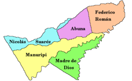
and is situated in the department's north-western parts. Its name derives from Manuripi River which passes the province from West to East
Location
Manuripi province is located between 10° 49’ and 12° 30' SouthLatitude
In geography, the latitude of a location on the Earth is the angular distance of that location south or north of the Equator. The latitude is an angle, and is usually measured in degrees . The equator has a latitude of 0°, the North pole has a latitude of 90° north , and the South pole has a...
and between 66° 00' and 69° 14' West
Longitude
Longitude is a geographic coordinate that specifies the east-west position of a point on the Earth's surface. It is an angular measurement, usually expressed in degrees, minutes and seconds, and denoted by the Greek letter lambda ....
. It extends over a length of 370 km from Northeast to Southwest, and up to 100 km from Northwest to Southeast.
The province is situated in the Amazon
Amazon Rainforest
The Amazon Rainforest , also known in English as Amazonia or the Amazon Jungle, is a moist broadleaf forest that covers most of the Amazon Basin of South America...
lowlands of Bolivia and borders Abuná Province
Abuná Province
Abuná is one of the five provinces of the Bolivian department of Pando and is situated in the department's northern central parts. It has its name from Río Abuná, the border river to neighbouring Brazil.- Location :...
in the North, Nicolás Suárez Province
Nicolás Suárez Province
Nicolás Suárez is one of the five provinces of the Bolivian Pando department and is situated in the department's northwestern parts. Its name honors Nicolás Suárez Callaú who owned major parts of today's Pando and Beni Departments in the times of the caoutchouc-boom.- Location :Nicolás Suárez...
in the Northwest, Peru
Peru
Peru , officially the Republic of Peru , is a country in western South America. It is bordered on the north by Ecuador and Colombia, on the east by Brazil, on the southeast by Bolivia, on the south by Chile, and on the west by the Pacific Ocean....
in the West, La Paz Department in the South, Madre de Dios Province
Madre de Dios Province
Madre de Dios is one of the five provinces of the Bolivian Pando department and is situated in the department's southern parts. Its name derives from Río Madre de Dios which forms the province's northern border. - Location :...
in the Southeast, Beni Department
Beni Department
Beni, sometimes El Beni, is a northeastern department of Bolivia, in the lowlands region of the country. It is the second largest department in the country , covering 213,564 square kilometers , and it was created by supreme decree on November 18, 1842 during the administration of General José...
in the East, and Federico Román Province
Federico Román Province
Federico Román is one of the five provinces of the Bolivian department of Pando and is situated in the department's northeastern parts. Its name honours General Federico Román.- Location :...
in the Northeast.
Population
The population of Federico Román Province has increased by 40 % over the recent two decades:- 1992: 7,360 inhabitants (censusCensusA census is the procedure of systematically acquiring and recording information about the members of a given population. It is a regularly occurring and official count of a particular population. The term is used mostly in connection with national population and housing censuses; other common...
) - 2001: 8,230 inhabitants (censusCensusA census is the procedure of systematically acquiring and recording information about the members of a given population. It is a regularly occurring and official count of a particular population. The term is used mostly in connection with national population and housing censuses; other common...
) - 2005: 9,505 inhabitants (est.)
- 2010: 10,164 inhabitants (est.)
47.7 % of the population are younger than 15 years old. (1992)
98.0 % of the population speak Spanish
Spanish language
Spanish , also known as Castilian , is a Romance language in the Ibero-Romance group that evolved from several languages and dialects in central-northern Iberia around the 9th century and gradually spread with the expansion of the Kingdom of Castile into central and southern Iberia during the...
, 0.4 % speak Quechua, and speak 0.2 % Aymara
Aymara language
Aymara is an Aymaran language spoken by the Aymara people of the Andes. It is one of only a handful of Native American languages with over three million speakers. Aymara, along with Quechua and Spanish, is an official language of Peru and Bolivia...
. (1992)
The literacy rate
Literacy
Literacy has traditionally been described as the ability to read for knowledge, write coherently and think critically about printed material.Literacy represents the lifelong, intellectual process of gaining meaning from print...
of the province's population is 75.4 %. (1992)
91.0 % of the population have no access to electricity, 68.5 % have no sanitary facilities. (1992)
84.4 % of the population are Catholics, 14.6 % are Protestants. (1992)
Division
The province comprises three municipalitiesMunicipalities of Bolivia
Municipalities in Bolivia are administrative divisions of the entire national territory governed by local elections. Municipalities are the third level of administrative divisions, below departments and provinces. Some of the provinces consist of only one municipality...
:
- Filadelfia Municipality – 3,145 inhabitants (2005)
- Puerto Rico Municipality – 4,003 inhabitants
- San Pedro Municipality – 1,082 inhabitants