Celebes Sea
Encyclopedia
The Celebes Sea of the western Pacific Ocean
Pacific Ocean
The Pacific Ocean is the largest of the Earth's oceanic divisions. It extends from the Arctic in the north to the Southern Ocean in the south, bounded by Asia and Australia in the west, and the Americas in the east.At 165.2 million square kilometres in area, this largest division of the World...

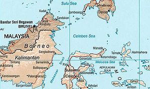
 is bordered on the north by the Sulu Archipelago
Sulu Archipelago
The Sulu Archipelago is a chain of islands in the southwestern Philippines. This archipelago is considered to be part of the Moroland by the local rebel independence movement. This island group forms the northern limit of the Celebes Sea....

 and Sulu Sea
Sulu Sea
The Sulu Sea is a body of water in the southwestern area of the Philippines, separated from the South China Sea in the northwest by Palawan and from the Celebes Sea in the southeast by the Sulu Archipelago. Borneo is found to the southwest and Visayas to the northeast.Sulu Sea contains a number of...

 and Mindanao Island of the Philippines
Philippines
The Philippines , officially known as the Republic of the Philippines , is a country in Southeast Asia in the western Pacific Ocean. To its north across the Luzon Strait lies Taiwan. West across the South China Sea sits Vietnam...

, on the east by the Sangihe Islands
Sangihe Islands
The Sangihe Islands – – are a group of islands constitute 2 regencies in northern Indonesia, the Sangihe Islands Regency & Sitaro Islands Regency...

 chain, on the south by Sulawesi
Sulawesi
Sulawesi is one of the four larger Sunda Islands of Indonesia and is situated between Borneo and the Maluku Islands. In Indonesia, only Sumatra, Borneo, and Papua are larger in territory, and only Java and Sumatra have larger Indonesian populations.- Etymology :The Portuguese were the first to...

, and on the west by Kalimantan
Kalimantan
In English, the term Kalimantan refers to the Indonesian portion of the island of Borneo, while in Indonesian, the term "Kalimantan" refers to the whole island of Borneo....

 in Indonesia
Indonesia
Indonesia , officially the Republic of Indonesia , is a country in Southeast Asia and Oceania. Indonesia is an archipelago comprising approximately 13,000 islands. It has 33 provinces with over 238 million people, and is the world's fourth most populous country. Indonesia is a republic, with an...

. It extends 420 miles (675 km) north-south by 520 miles (837 km) east-west and has a total surface area of 110000 square miles (284,898.7 km²), to a maximum depth of 20,300 feet (6,200 m). The sea opens southwest through the Makassar Strait
Makassar Strait
Makassar Strait is a strait between the islands of Borneo and Sulawesi in Indonesia. To the north it joins the Celebes Sea, while to the south it meets the Java Sea.The Mahakam River of Borneo empties into the strait....

 into the Java Sea
Java Sea
The Java Sea is a large shallow sea on the Sunda Shelf. It was formed as sea levels rose at the end of the last ice age. The Java Sea lies between the Indonesian islands of Borneo to the north, Java to the south; Sumatra to the west, and Sulawesi to the east...

.

The Celebes Sea is a piece of an ancient ocean basin that formed 42 million years ago in a locale removed from any landmass. By 20,000,000 years ago, earth crust movement had moved the basin close enough to the Indonesia
Indonesia
Indonesia , officially the Republic of Indonesia , is a country in Southeast Asia and Oceania. Indonesia is an archipelago comprising approximately 13,000 islands. It has 33 provinces with over 238 million people, and is the world's fourth most populous country. Indonesia is a republic, with an...

n and Philippine
Philippines
The Philippines , officially known as the Republic of the Philippines , is a country in Southeast Asia in the western Pacific Ocean. To its north across the Luzon Strait lies Taiwan. West across the South China Sea sits Vietnam...

 volcano
Volcano
2. Bedrock3. Conduit 4. Base5. Sill6. Dike7. Layers of ash emitted by the volcano8. Flank| 9. Layers of lava emitted by the volcano10. Throat11. Parasitic cone12. Lava flow13. Vent14. Crater15...

es to receive emitted debris. By 10 million years ago the Celebes Sea was inundated with continental debris, including coal
Coal
Coal is a combustible black or brownish-black sedimentary rock usually occurring in rock strata in layers or veins called coal beds or coal seams. The harder forms, such as anthracite coal, can be regarded as metamorphic rock because of later exposure to elevated temperature and pressure...

, which was shed from a growing young mountain on Borneo and the basin had docked against Eurasia.

The border between the Celebes and the Sulu Sea is at the Sibutu-Basilan Ridge. Strong ocean current
Ocean current
An ocean current is a continuous, directed movement of ocean water generated by the forces acting upon this mean flow, such as breaking waves, wind, Coriolis effect, cabbeling, temperature and salinity differences and tides caused by the gravitational pull of the Moon and the Sun...

s, deep sea trench
Oceanic trench
The oceanic trenches are hemispheric-scale long but narrow topographic depressions of the sea floor. They are also the deepest parts of the ocean floor....

es and seamount
Seamount
A seamount is a mountain rising from the ocean seafloor that does not reach to the water's surface , and thus is not an island. These are typically formed from extinct volcanoes, that rise abruptly and are usually found rising from a seafloor of depth. They are defined by oceanographers as...

s, combined with active volcanic islands, result in complex oceanographic features.

Extent

The International Hydrographic Organization
International Hydrographic Organization
The International Hydrographic Organization is the inter-governmental organisation representing the hydrographic community. It enjoys observer status at the UN and is the recognised competent authority on hydrographic surveying and nautical charting...

 (IHO) defines the Celebes Sea as being one of the waters of the East Indian Archipelago
East Indian Archipelago
The East Indian Archipelago is a marine area designated by the International Hydrographic Organization . It consists of a number of seas and straits in the East Indies ....

. The IHO defines its limits as follows:

On the North. The Southern limit of Sulu Sea
Sulu Sea
The Sulu Sea is a body of water in the southwestern area of the Philippines, separated from the South China Sea in the northwest by Palawan and from the Celebes Sea in the southeast by the Sulu Archipelago. Borneo is found to the southwest and Visayas to the northeast.Sulu Sea contains a number of...

 [From Tagolo Point, down the West coast of Mindanao
Mindanao
Mindanao is the second largest and easternmost island in the Philippines. It is also the name of one of the three island groups in the country, which consists of the island of Mindanao and smaller surrounding islands. The other two are Luzon and the Visayas. The island of Mindanao is called The...

 to the Southwest extremity thence to the North coast of Basilan Island
Basilan (island)
Basilan Island is an island of the Philippines, it belongs to Basilan Province with its capital Isabela City.Basilan is geographically located between latitude 6°15' and 7°00' longitude 121°15' and 122°30'....

 (6°45′N 122°04′E), through this island to its Southern extremity, thence a line to Bitinan Island (6°04′N 121°27′E) off the Eastern end of Jolo Island
Jolo
Jolo may refer to:* Jolo Island* Jolo, Sulu* Jolo, West Virginia* Jolo is also the nickname of Swedish author Jan Olof Olsson....

, through Jolo to a point in long. 121°04'E on its South coast, thence through Tapul
Tapul, Sulu
Tapul is a municipality in the province of Sulu, Philippines. According to the 2000 census, it has a population of 14,881 people in 2,117 households.-Barangays:Tapul is politically subdivided into 15 barangays.* Alu-Kabingaan* Banting* Hawan...

 and Lugus
Lugus, Sulu
Lugus is a 5th class municipality in the province of Sulu, Philippines. According to the 2000 census, it has a population of 18,839 people in 2,907 households.-Barangays:Lugus is politically subdivided into 17 barangays.* Alu Bus-Bus* Alu-Duyong...

 Islands and along the North coast of Tawitawi Island
Tawi-Tawi
Tawi-Tawi is an island province of the Philippines located in the Autonomous Region in Muslim Mindanao . The capital of Tawi-Tawi is Bongao. The province is the southernmost of the country sharing sea borders with the Malaysian State of Sabah and the Indonesian East Kalimantan province. To the...

 to Bongao Island
Bongao, Tawi-Tawi
Bongao is a 3rd class municipality in the province of Tawi-Tawi, Philippines. According to the 2000 census, it has a population of 58,174 people in 10,146 households.-History:...

 off its Western end (5°01′N 119°45′E), and from thence to Tanjong Labian, the Northeastern extreme of Borneo] and the Southwest coast of Mindanao.

On the East. A line from Tanjong Tinaka, the Southern point of Mindanao, to the North point of Sangi (3°45′N 125°26′E) thence through the Sangi Islands to Tanjong Poeisan, the Northeast extreme of Celebes [Sulawesi

Sulawesi
Sulawesi is one of the four larger Sunda Islands of Indonesia and is situated between Borneo and the Maluku Islands. In Indonesia, only Sumatra, Borneo, and Papua are larger in territory, and only Java and Sumatra have larger Indonesian populations.- Etymology :The Portuguese were the first to...

].

On the South. The North coast of Celebes between Tanjong Poeisan and Stroomenkaap (Cape Rivers) (1°20′N 120°52′E) and thence a line to Tanjong Mangkalihat in Borneo

Borneo
Borneo is the third largest island in the world and is located north of Java Island, Indonesia, at the geographic centre of Maritime Southeast Asia....

, the Northern limit of Makassar Strait
Makassar Strait
Makassar Strait is a strait between the islands of Borneo and Sulawesi in Indonesia. To the north it joins the Celebes Sea, while to the south it meets the Java Sea.The Mahakam River of Borneo empties into the strait....

 [a line joining Tanjong Mangkalihat, Borneo (1°02′N 118°57′E) and Stroomen Kaap (Cape Rivers), Celebes (1°20′N 120°52′E)].

On the West. The East coast of Borneo between Tanjong Mangkalihat and Tanjong Labian, the Southern limit of the Sulu Sea.


Celebes Sea pirates

The Celebes Sea has somewhat attained an international notoriety for its pirates who prey not only on small time fishermen but also giant container ships. Nowadays, these pirates have high-tech weapons and equipment like radar
Radar
Radar is an object-detection system which uses radio waves to determine the range, altitude, direction, or speed of objects. It can be used to detect aircraft, ships, spacecraft, guided missiles, motor vehicles, weather formations, and terrain. The radar dish or antenna transmits pulses of radio...

 and GPS navigation devices and ride on high-speed motorboats. It is the second most pirated body of water after the Gulf of Aden
Gulf of Aden
The Gulf of Aden is located in the Arabian Sea between Yemen, on the south coast of the Arabian Peninsula, and Somalia in the Horn of Africa. In the northwest, it connects with the Red Sea through the Bab-el-Mandeb strait, which is about 20 miles wide....

 near Somalia
Somalia
Somalia , officially the Somali Republic and formerly known as the Somali Democratic Republic under Socialist rule, is a country located in the Horn of Africa. Since the outbreak of the Somali Civil War in 1991 there has been no central government control over most of the country's territory...

.

Marine life

The Celebes Sea is home to a wide variety of fish and aquatic creatures. The tropical setting and warm clear waters permit it to harbor about 580 of the world's 793 species of reef-building coral
Coral
Corals are marine animals in class Anthozoa of phylum Cnidaria typically living in compact colonies of many identical individual "polyps". The group includes the important reef builders that inhabit tropical oceans and secrete calcium carbonate to form a hard skeleton.A coral "head" is a colony of...

s, which grow as some of the most bio-diverse coral reefs in the world, and an impressive array of marine life, including whale
Whale
Whale is the common name for various marine mammals of the order Cetacea. The term whale sometimes refers to all cetaceans, but more often it excludes dolphins and porpoises, which belong to suborder Odontoceti . This suborder also includes the sperm whale, killer whale, pilot whale, and beluga...

s and dolphin
Dolphin
Dolphins are marine mammals that are closely related to whales and porpoises. There are almost forty species of dolphin in 17 genera. They vary in size from and , up to and . They are found worldwide, mostly in the shallower seas of the continental shelves, and are carnivores, mostly eating...

s, sea turtle
Sea turtle
Sea turtles are marine reptiles that inhabit all of the world's oceans except the Arctic.-Distribution:...

s, manta ray
Manta ray
The manta ray is the largest species of the rays. The largest known specimen was more than across, with a weight of about . It ranges throughout waters of the world, typically around coral reefs...

s, eagle ray
Eagle ray
The eagle rays are a group of cartilaginous fishes in the family Myliobatidae, consisting mostly of large species living in the open ocean rather than on the sea bottom....

s, barracuda
Barracuda
The barracuda is a ray-finned fish known for its large size and fearsome appearance. Its body is long, fairly compressed, and covered with small, smooth scales. Some species could reach up to 1.8m in length and 30 cm in width...

, marlin
Marlin
Marlin, family Istiophoridae, are fish with an elongated body, a spear-like snout or bill, and a long rigid dorsal fin, which extends forward to form a crest. Its common name is thought to derive from its resemblance to a sailor's marlinspike...

 and other reef and pelagic species. Tuna
Tuna
Tuna is a salt water fish from the family Scombridae, mostly in the genus Thunnus. Tuna are fast swimmers, and some species are capable of speeds of . Unlike most fish, which have white flesh, the muscle tissue of tuna ranges from pink to dark red. The red coloration derives from myoglobin, an...

 and yellowfin tuna
Yellowfin tuna
The yellowfin tuna is a species of tuna found in pelagic waters of tropical and subtropical oceans worldwide.Yellowfin is often marketed as ahi, from its Hawaiian name ahi although the name ahi in Hawaiian also refers to the closely related bigeye tuna. The species name, albacares can lead to...

 are also abundant.

In addition to high abundance of fish caught in the Celebes sea, this sea also yields other aquatic products like sea tang.

Commercial significance

An important sea route for regional trade. The sea is also popular for scuba diving
Diving
Diving is the sport of jumping or falling into water from a platform or springboard, sometimes while performing acrobatics. Diving is an internationally-recognized sport that is part of the Olympic Games. In addition, unstructured and non-competitive diving is a recreational pastime.Diving is one...

 and luxury ocean cruising.

See also

  • Bunaken
    Bunaken
    Bunaken is an island of 8 km², part of the Bunaken National Marine Park. Bunaken is located at the northern tip of the island of Sulawesi, Indonesia. It belongs administratively to the municipality of Manado...

  • Davao Gulf
    Davao Gulf
    Davao Gulf is a gulf found in Mindanao in the Philippines. It has an area of 308,000 hectares. Davao Gulf cuts into the island of Mindanao from Celebes Sea. It is surrounded by all four provinces in the Davao Region. The largest island in the gulf is Samal Island. Davao City, on the gulf's west...

  • Maitum, Sarangani
    Maitum, Sarangani
    Maitum is a 2nd class municipality in the province of Sarangani, Philippines. According to the latest census, it has a population of 37,054 people in 7,640 households....

  • Minahassa Peninsula
  • Moro Gulf
    Moro Gulf
    The Moro Gulf is a sea in Mindanao in the Philippines. It is part of Celebes Sea and is surrounded by the Zamboanga Peninsula and the central part of Mindanao. Sibuguey Bay and Illana Bay are its major branches. Zamboanga City is the most important port city on its coast...

  • Sangir Islands
  • Sarangani Bay
    Sarangani Bay
    Sarangani Bay is a bay located on the southern tip of Mindanao in the Philippines. It opens up to the Celebes Sea on the Pacific Ocean. General Santos City, one of the Philippines most important cities and ports, is located on the bay, making the bay one of the busiest and often the sight of...

  • Talaud Islands
    Talaud Islands
    Talaud Islands is a group of islands located north of Sulawesi island in Indonesia, northeast of the Sangihe Islands...


External links

The source of this article is wikipedia, the free encyclopedia.  The text of this article is licensed under the GFDL.
 
x
OK