
Ludgershall, Wiltshire
Encyclopedia
Ludgershall is a town and civil parish
16 miles (25.7 km) north east of Salisbury
, Wiltshire
, at grid SU264509. The population was: 535 in 1831; 1,906 in 1951; and 3,775 in 2001. Ludgershall is now officially a town.
(1066) reads as follows:
"Edward of Salisbury holds Ludgershall. Alfward held it before 1066; it paid tax for one hide (about 24 acres). Land for 3 ploughs. In Lordship 2 ploughs 3 slaves; 8 Cottagers with 1 plough. Pasture 3 furlongs long and 1 furlong wide; woodland 1/2 league long and 2 furlongs wide. The value was 100s
Ludgershall was originally called Litlegarsele (often rendered as lytel, small and garsheath, a grassy place so a "Small grazing area" or "little grass heath" and in 1141 the Empress Maud took refuge in Ludgershall Castle as she fled from Stephen's army. She was accompanied by Milo Fitzwalter and escaped disguised as a corpse to Vies (Devizes) and thence to Gloucester
. Some 600 years later a seal was found by a ploughman, bearing a knight in armour and holding a lance shield with the inscription "Sigillum Millonis De Glocestria". It is thought Fitzwalter threw away the seal to avoid identification when he escaped as a beggar. During succeeding centuries Ludgershall Castle was occupied by many distinguished persons and royalty frequently resided there. The village grew around the castle and it is reported that from 1295 to 1831 Ludgershall returned two members to Parliament.
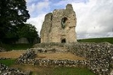
The town now features the remains of this 12th century fortified royal residence known as Ludgershall Castle. Three large walls still remain of the private residence, which was turned into a hunting lodge by Henry III
but fell into disuse by the 15th century. The property is now under the care of English Heritage
. Extensive earthworks remain, although a large section of the original plot is now a private residence.
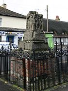 The remains of a preaching cross
are situated in the town centre. This is also under the care of English Heritage
. It was erected some time in the early 19th century in the area that formed the old market place, near the present Queen's Head at the end of High Street. It is some 12 feet in height and in 1897, to celebrate the Diamond Jubilee of Queen Victoria, an ornamental iron fence was erected around the cross. The cross has carved representations on four sides but they are badly eroded. It is thought the original sculptured panels represented:
North Side - The Ascencion
South Side - The three Marys
East Side - The Crucifixion
West Side - Command to St Paul
The railings were designed by Mr A. H. Huth and bear a crown in each corner. This preaching cross is now the emblem of the Border Lodge no. 3129, a local Masonic lodge consecrated in 1905.
Ludgershall was an important place in medieval England and as such was invited to send members to Parliament
; it retained this privilege until the Reform Act
of 1832. The small size of Ludgershall led to it being cited as an example of a 'Rotten Borough
'.
, it was always going to have some form of British Army
connection. During World War II
, Army depots were built to the north and south of Tidworth Road and a fire station opened in High Street. A senior school also opened near the Ludgershall boundary with Tidworth. The War Office transferred the Army Medical Store to a site west of the railway station, with the stores were rebuilt in 1971 and 1982. In 1943 a railway line from the army depot south of Tidworth Road was built to join the Ludgershall to Tidworth line that had been opened in 1901. The U.S. Army prepared vehicles for the invasion of Europe at the depot in 1943. Ludgershall railway station closed in 1961 along with the northern section of the Midland and South Western Junction Railway
to Swindon
, the southern section to Andover
remains open to allow the British Army to transport tanks and other equipment to and from the depot and onwards to Salisbury Plain
. The town is now host to 26 Engineer Regiment, Royal Engineers
based at the depot, the barracks area is named 'Corunna Barracks'.(after the 1809 engagement of the Peninsular War and where Sir John Moore fell in battle. Corunna is the anglicised form of La Coruna. The city is perhaps well known for the football team Deportivo La Coruna). This site is host to a large number of warehouses which are able to hold hundreds of vehicles ranging from Land Rovers to heavily armoured vehicles. The 'test tracks' and old parade ground behind the site are now used for vehicle storage, army exercises and practice driving areas by the local residents.
properties in the area. The community is well provided for in terms of entertainment and shops with two pubs and social clubs, a number of small independent traders, and two supermarket chains.
Civil parish
In England, a civil parish is a territorial designation and, where they are found, the lowest tier of local government below districts and counties...
16 miles (25.7 km) north east of Salisbury
Salisbury
Salisbury is a cathedral city in Wiltshire, England and the only city in the county. It is the second largest settlement in the county...
, Wiltshire
Wiltshire
Wiltshire is a ceremonial county in South West England. It is landlocked and borders the counties of Dorset, Somerset, Hampshire, Gloucestershire, Oxfordshire and Berkshire. It contains the unitary authority of Swindon and covers...
, at grid SU264509. The population was: 535 in 1831; 1,906 in 1951; and 3,775 in 2001. Ludgershall is now officially a town.
Historical features
The entry in the Domesday BookDomesday Book
Domesday Book , now held at The National Archives, Kew, Richmond upon Thames in South West London, is the record of the great survey of much of England and parts of Wales completed in 1086...
(1066) reads as follows:
"Edward of Salisbury holds Ludgershall. Alfward held it before 1066; it paid tax for one hide (about 24 acres). Land for 3 ploughs. In Lordship 2 ploughs 3 slaves; 8 Cottagers with 1 plough. Pasture 3 furlongs long and 1 furlong wide; woodland 1/2 league long and 2 furlongs wide. The value was 100s
Ludgershall was originally called Litlegarsele (often rendered as lytel, small and garsheath, a grassy place so a "Small grazing area" or "little grass heath" and in 1141 the Empress Maud took refuge in Ludgershall Castle as she fled from Stephen's army. She was accompanied by Milo Fitzwalter and escaped disguised as a corpse to Vies (Devizes) and thence to Gloucester
Gloucester
Gloucester is a city, district and county town of Gloucestershire in the South West region of England. Gloucester lies close to the Welsh border, and on the River Severn, approximately north-east of Bristol, and south-southwest of Birmingham....
. Some 600 years later a seal was found by a ploughman, bearing a knight in armour and holding a lance shield with the inscription "Sigillum Millonis De Glocestria". It is thought Fitzwalter threw away the seal to avoid identification when he escaped as a beggar. During succeeding centuries Ludgershall Castle was occupied by many distinguished persons and royalty frequently resided there. The village grew around the castle and it is reported that from 1295 to 1831 Ludgershall returned two members to Parliament.
The town now features the remains of this 12th century fortified royal residence known as Ludgershall Castle. Three large walls still remain of the private residence, which was turned into a hunting lodge by Henry III
Henry III of England
Henry III was the son and successor of John as King of England, reigning for 56 years from 1216 until his death. His contemporaries knew him as Henry of Winchester. He was the first child king in England since the reign of Æthelred the Unready...
but fell into disuse by the 15th century. The property is now under the care of English Heritage
English Heritage
English Heritage . is an executive non-departmental public body of the British Government sponsored by the Department for Culture, Media and Sport...
. Extensive earthworks remain, although a large section of the original plot is now a private residence.
Preaching cross
A preaching cross is a cross, sometimes surmounting a pulpit, erected out of doors to designate a preaching place.In Britain and Ireland, many free-standing upright crosses – or high crosses – were erected. Some of these crosses bear figurative or decorative carvings, or inscriptions in runes...
are situated in the town centre. This is also under the care of English Heritage
English Heritage
English Heritage . is an executive non-departmental public body of the British Government sponsored by the Department for Culture, Media and Sport...
. It was erected some time in the early 19th century in the area that formed the old market place, near the present Queen's Head at the end of High Street. It is some 12 feet in height and in 1897, to celebrate the Diamond Jubilee of Queen Victoria, an ornamental iron fence was erected around the cross. The cross has carved representations on four sides but they are badly eroded. It is thought the original sculptured panels represented:
North Side - The Ascencion
South Side - The three Marys
East Side - The Crucifixion
West Side - Command to St Paul
The railings were designed by Mr A. H. Huth and bear a crown in each corner. This preaching cross is now the emblem of the Border Lodge no. 3129, a local Masonic lodge consecrated in 1905.
Ludgershall was an important place in medieval England and as such was invited to send members to Parliament
Parliament of England
The Parliament of England was the legislature of the Kingdom of England. In 1066, William of Normandy introduced a feudal system, by which he sought the advice of a council of tenants-in-chief and ecclesiastics before making laws...
; it retained this privilege until the Reform Act
Reform Act
In the United Kingdom, Reform Act is a generic term used for legislation concerning electoral matters. It is most commonly used for laws passed to enfranchise new groups of voters and to redistribute seats in the British House of Commons...
of 1832. The small size of Ludgershall led to it being cited as an example of a 'Rotten Borough
Rotten borough
A "rotten", "decayed" or pocket borough was a parliamentary borough or constituency in the United Kingdom that had a very small electorate and could be used by a patron to gain undue and unrepresentative influence within Parliament....
'.
M.o.D. Ludgershall
As the town is strategically situated on the south eastern corner of Salisbury PlainSalisbury Plain
Salisbury Plain is a chalk plateau in central southern England covering . It is part of the Southern England Chalk Formation and largely lies within the county of Wiltshire, with a little in Hampshire. The plain is famous for its rich archaeology, including Stonehenge, one of England's best known...
, it was always going to have some form of British Army
British Army
The British Army is the land warfare branch of Her Majesty's Armed Forces in the United Kingdom. It came into being with the unification of the Kingdom of England and Scotland into the Kingdom of Great Britain in 1707. The new British Army incorporated Regiments that had already existed in England...
connection. During World War II
World War II
World War II, or the Second World War , was a global conflict lasting from 1939 to 1945, involving most of the world's nations—including all of the great powers—eventually forming two opposing military alliances: the Allies and the Axis...
, Army depots were built to the north and south of Tidworth Road and a fire station opened in High Street. A senior school also opened near the Ludgershall boundary with Tidworth. The War Office transferred the Army Medical Store to a site west of the railway station, with the stores were rebuilt in 1971 and 1982. In 1943 a railway line from the army depot south of Tidworth Road was built to join the Ludgershall to Tidworth line that had been opened in 1901. The U.S. Army prepared vehicles for the invasion of Europe at the depot in 1943. Ludgershall railway station closed in 1961 along with the northern section of the Midland and South Western Junction Railway
Midland and South Western Junction Railway
The Midland and South Western Junction Railway was, until the 1923 Grouping, an independent railway built to form a north-south link between the Midland and London and South Western Railways allowing the Midland and other companies' trains to reach the port of Southampton.-Formation:The M&SWJR...
to Swindon
Swindon
Swindon is a large town within the borough of Swindon and ceremonial county of Wiltshire, in South West England. It is midway between Bristol, west and Reading, east. London is east...
, the southern section to Andover
Andover, Hampshire
Andover is a town in the English county of Hampshire. The town is on the River Anton some 18.5 miles west of the town of Basingstoke, 18.5 miles north-west of the city of Winchester and 25 miles north of the city of Southampton...
remains open to allow the British Army to transport tanks and other equipment to and from the depot and onwards to Salisbury Plain
Salisbury Plain
Salisbury Plain is a chalk plateau in central southern England covering . It is part of the Southern England Chalk Formation and largely lies within the county of Wiltshire, with a little in Hampshire. The plain is famous for its rich archaeology, including Stonehenge, one of England's best known...
. The town is now host to 26 Engineer Regiment, Royal Engineers
Royal Engineers
The Corps of Royal Engineers, usually just called the Royal Engineers , and commonly known as the Sappers, is one of the corps of the British Army....
based at the depot, the barracks area is named 'Corunna Barracks'.(after the 1809 engagement of the Peninsular War and where Sir John Moore fell in battle. Corunna is the anglicised form of La Coruna. The city is perhaps well known for the football team Deportivo La Coruna). This site is host to a large number of warehouses which are able to hold hundreds of vehicles ranging from Land Rovers to heavily armoured vehicles. The 'test tracks' and old parade ground behind the site are now used for vehicle storage, army exercises and practice driving areas by the local residents.
County confusion
A common misconception is that the town is situated in the county of Hampshire rather than Wiltshire. This problem is compounded by the postal code of SP11 and telephone dialling code of 01264 which both signify it to be in Andover, Hampshire. This confusion is perpetuated by companies using automatic addressing systems based upon the post code. The local newspaper is the Andover Advertiser - based in Hampshire.Faberstown
At the beginning of the 20th century, a local MP, Walter Faber, began building to the east of the town, actually in Hampshire. This settlement became known as Faberstown. By 1970, Ludgershall and Faberstown were in essence a single village, although in separate counties. A boundary change in 1992 took the entire village into Wiltshire.The modern village
The village of Ludgershall has developed considerably over the years and is now an important village supporting a number of flourishing businesses and a considerable amount of housing. It is likely to expand further over the next several years with the current proposals for a new business park on 33 acres (133,546.4 m²) on the outskirts of the town, and the redevelopment of former MoDMinistry of Defence (United Kingdom)
The Ministry of Defence is the United Kingdom government department responsible for implementation of government defence policy and is the headquarters of the British Armed Forces....
properties in the area. The community is well provided for in terms of entertainment and shops with two pubs and social clubs, a number of small independent traders, and two supermarket chains.