

Long Hunter State Park
Encyclopedia
State park
State parks are parks or other protected areas managed at the federated state level within those nations which use "state" as a political subdivision. State parks are typically established by a state to preserve a location on account of its natural beauty, historic interest, or recreational...
in Davidson County
Davidson County, Tennessee
Davidson County is a county located in the U.S. state of Tennessee. As of 2010, the population was 626,681. Its county seat is Nashville.In 1963, the City of Nashville and the Davidson County government merged, so the county government is now known as the "Metropolitan Government of Nashville and...
and Rutherford County
Rutherford County, Tennessee
Rutherford County is a county located in the U.S. state of Tennessee. As of the 2010 census, it is the state's fifth-largest county by population with 262,604 people, an increase of 44.3 percent over the 2000 population of 182,023. Its county seat is Murfreesboro, which is also the geographic...
, Tennessee
Tennessee
Tennessee is a U.S. state located in the Southeastern United States. It has a population of 6,346,105, making it the nation's 17th-largest state by population, and covers , making it the 36th-largest by total land area...
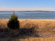
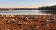
, located in the southeastern United States. The park is mostly situated along the eastern shores of Percy Priest Lake
Percy Priest Lake
J. Percy Priest Lake is a reservoir in north central Tennessee. It is formed by J. Percy Priest Dam, located between miles six and seven of the Stones River. The dam is located about 10 miles east of downtown Nashville and impounds a lake 42 miles long...
, an artificial lake created by an impoundment of the Stones River
Stones River
The Stones River is a major stream of the eastern portion of Tennessee's Nashville Basin region.-Geography and hydrography:The Stones River is composed of three major forks: the West, Middle, and East forks. The West Fork, long, rises in southernmost Rutherford County near the Bedford County...
.
Long Hunter State Park comprises three lake sections — Baker's Grove in the north, Couchville at the center, and Bryant Grove to the south. All three sections are connected by narrow strips of land. The park also manages Sellars Farm, a state archaeological area near Lebanon
Lebanon, Tennessee
Lebanon is a city in Wilson County, Tennessee, in the United States. The population was 20,235 at the 2000 census. It serves as the county seat of Wilson County. Lebanon is located in middle Tennessee, approximately 25 miles east of downtown Nashville. Local residents have also called it...
to the east.
Geographical setting

Murfreesboro, Tennessee
Murfreesboro is a city in and the county seat of Rutherford County, Tennessee, United States. The population was 108,755 according to the United States Census Bureau's 2010 U.S. Census, up from 68,816 residents certified during the 2000 census. The center of population of Tennessee is located in...
and Stones River National Battlefield
Stones River National Battlefield
Stones River National Battlefield, a park along the Stones River in Rutherford County, Tennessee, three miles northwest of Murfreesboro and twenty-eight miles southeast of...
, and merges with the East Fork of Stones River near Smyrna
Smyrna, Tennessee
Smyrna is a town in Rutherford County, Tennessee, United States. Smyrna's population was 25,569 people at the 2000 census. The Census estimate of the 2009 population is 39,142.-Geography:Smyrna is located at ....
. The East Fork flows westward from its source atop Short Mountain, at the edge of the Highland Rim
Highland Rim
The Highland Rim is a geographic term for the area in Tennessee surrounding the Central Basin. Nashville is largely surrounded by higher terrain in all directions....
, and passes north of Murfreesboro. The confluence of these two rivers forms Stones River proper, and marks the southern extreme of J. Percy Priest Lake.
Stones River's J. Percy Priest Lake impoundment stretches for approximately 22 miles (35.4 km) between the confluence of the West Fork and East Fork to the south and the J. Percy Priest Dam near Donelson
Donelson, Tennessee
Donelson is a neighborhood of Nashville, Tennessee located east of downtown Nashville along U.S. Highway 70. It is named in honor of John Donelson, co-founder of Nashville and father-in-law of Andrew Jackson, Nashvillian and seventh President of the United States...
to the north. Downstream from the dam, Stones River winds its way through a series of bends toward its mouth along the Cumberland River
Cumberland River
The Cumberland River is a waterway in the Southern United States. It is long. It starts in Harlan County in far southeastern Kentucky between Pine and Cumberland mountains, flows through southern Kentucky, crosses into northern Tennessee, and then curves back up into western Kentucky before...
, just east of Nashville. Long Hunter State Park is officially located in Hermitage
Hermitage, Tennessee
Hermitage, Tennessee is a section of Metropolitan Nashville, Tennessee located in eastern Davidson County, adjacent to, and named in honor of, The Hermitage, home of Andrew Jackson, seventh President of the United States...
, a suburb of Nashville.
Tennessee State Route 171 follows Mount Juliet Road south from Interstate 40
Interstate 40
Interstate 40 is the third-longest major east–west Interstate Highway in the United States, after I-90 and I-80. Its western end is at Interstate 15 in Barstow, California; its eastern end is at a concurrency of U.S. Route 117 and North Carolina Highway 132 in Wilmington, North Carolina...
to the park's boundary. The two roads then split, with TN-171 continuing west along Hobson Pike to the park's Couchville section, and Mount Juliet Road (now South Mount Juliet Road) continuing south to the park's Bryant Grove section. Granny Wright Road, which intersects TN-171 just north of its split with Mount Juliet Road, accesses the Volunteer Trailhead and the park's Bakers Grove section.
History
Native AmericansNative Americans in the United States
Native Americans in the United States are the indigenous peoples in North America within the boundaries of the present-day continental United States, parts of Alaska, and the island state of Hawaii. They are composed of numerous, distinct tribes, states, and ethnic groups, many of which survive as...
were hunting in the Stones River Basin as early as 12,000 years ago, as evidenced by flint
Flint
Flint is a hard, sedimentary cryptocrystalline form of the mineral quartz, categorized as a variety of chert. It occurs chiefly as nodules and masses in sedimentary rocks, such as chalks and limestones. Inside the nodule, flint is usually dark grey, black, green, white, or brown in colour, and...
tools found on the grounds of Long Hunter State Park. The Nashville Basin
Nashville Basin
The Nashville Basin, also known as the Central Basin, is a term often used to describe the area surrounding Nashville, Tennessee. The Central Basin was caused by an uplifting known as the Nashville Dome. The Nashville Dome is evidenced by the underlying rock strata that all dip downwards away from...
is full of evidence of Paleo-Indian habitation, including Clovis point
Clovis point
Clovis points are the characteristically-fluted projectile points associated with the North American Clovis culture. They date to the Paleoindian period around 13,500 years ago. Clovis fluted points are named after the city of Clovis, New Mexico, where examples were first found in 1929.At the right...
s and a mastodon kill site in Williamson County
Williamson County, Tennessee
Williamson County is a county in the U.S. state of Tennessee. As of 2010 US Census, the population was 183,182. The County's seat is Franklin, and it is part of the Nashville-Davidson–Murfreesboro–Franklin Metropolitan Statistical Area. The county is named after Hugh Williamson, a...
, several miles west of Stones River on the other side of Nashville. A fortified Mississippian-era
Mississippian culture
The Mississippian culture was a mound-building Native American culture that flourished in what is now the Midwestern, Eastern, and Southeastern United States from approximately 800 CE to 1500 CE, varying regionally....
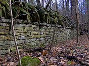
village was located near Lebanon at Sellars Farm, the site of which is now maintained by Long Hunter State Park. The Sellars Farm site was occupied between A.D. 1000–1300, and included a series of "platform" mounds and a central plaza.
Among the first Euro-Americans to explore the Nashville Basin were small groups of hunters known as long hunters
Longhunter
A Longhunter was an 18th-century explorer and hunter who made expeditions into the American frontier wilderness for as much as six months at a time...
. Long hunters had arrived in the region by the 1760s, typically following the Cumberland River valley from Virginia
Virginia
The Commonwealth of Virginia , is a U.S. state on the Atlantic Coast of the Southern United States. Virginia is nicknamed the "Old Dominion" and sometimes the "Mother of Presidents" after the eight U.S. presidents born there...
. The term "long hunter" referred to the relatively lengthy period of time (usually 6–18 months) a typical long hunt lasted. Most long hunters initially sought animal furs for sale back in Virginia, although later long hunters were employed as surveyors. Stones River, upon which Long Hunter State Park is situated, is named for Uriah Stone, a long hunter who allegedly had all of his furs stolen by a French companion while hunting along the river in 1767. Geographical and topographical information gathered by long hunters would later be invaluable to the Nashville area's first settlers.
Cherokee
The Cherokee are a Native American people historically settled in the Southeastern United States . Linguistically, they are part of the Iroquoian language family...
ceded the Stones River area to the United States in 1805, settlers began to arrive in large numbers. Among the first to settle at what is now Long Hunter State Park were Sherrod Bryant and his son, Henderson, who were living in the valley by 1820. The Bryants, who were the namesake for Bryant Grove, were one of the wealthiest African American
African American
African Americans are citizens or residents of the United States who have at least partial ancestry from any of the native populations of Sub-Saharan Africa and are the direct descendants of enslaved Africans within the boundaries of the present United States...
families in the state by the time of Sherrod's death in 1854. Other early settlers included the Couch family, who operated a store and river crossing just north of Bryant Grove.
In 1963, largely due to the demand for flood control along the volatile Stones River, the United States Army Corps of Engineers
United States Army Corps of Engineers
The United States Army Corps of Engineers is a federal agency and a major Army command made up of some 38,000 civilian and military personnel, making it the world's largest public engineering, design and construction management agency...
began construction on Stewart's Ferry Dam near Donelson. The dam — which was renamed for Congressman James Percy Priest
Percy Priest
James Percy Priest was an American teacher, journalist and politician who represented Tennessee in the United States House of Representatives from 1941 until his death.- Background :Priest was born in Maury County, Tennessee...
(1900–1956) — was completed in 1968. The impoundment of the river forced water to back up through underground channels, leading to the formation of Couchville Lake, the small lake situated near the center of the park. In 1972, the Corps of Engineers leased 2400 acres (9.7 km²) of land on the east shore of the reservoir to the state of Tennessee for the formation of a state park. Long Hunter State Park officially opened in 1978.
The Sellars Mound site, which had been excavated by Peabody Museum
Peabody Museum of Archaeology and Ethnology
The Peabody Museum of Archaeology and Ethnology is a museum affiliated with Harvard University in Cambridge, Massachusetts, USA.Founded in 1866, the Peabody Museum is one of the oldest and largest museums focusing on anthropological material, and is particularly strong in New World ethnography and...
curator Frederic Putnam in the late 1870s, was added to the National Register of Historic Places
National Register of Historic Places
The National Register of Historic Places is the United States government's official list of districts, sites, buildings, structures, and objects deemed worthy of preservation...
in 1972 and purchased by the state of Tennessee in 1974. In the late 1990s, the Friends of Sellars Farm State Archaeological Area was formed by volunteers who began promoting the site and offering tours. The site became a satellite of Long Hunter State Park in 2004.
The park today
Long Hunter State Park consists of approximately 2600 acres (10.5 km²) managed by the Tennessee Department of Environment and ConservationTennessee Department of Environment and Conservation
The Tennessee Department of Environment and Conservation is a Cabinet-level agency within the government of the U.S. state of Tennessee, headed by the Tennessee Commissioner of Environment and Conservation....
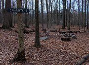
. The park includes two boat launch ramps on J. Percy Priest Lake, several miles of hiking trails, several group campsites and one backcountry campsite, a meeting facility, and a visitor center. Non-motorized boats are allowed on Couchville Lake.
The 5.5 miles (8.9 km) Volunteer Trail follows the lakeshore, connecting the Couchville and Bakers Grove sections. Two back country campsites are located at the end of the trail. A flat, paved trail circles Couchville Lake, and includes a 300 feet (91.4 m) bridge spanning the eastern end of the lake. The Jones Mill Trail, in the Bryant Grove section, leads to the top of Bald Knob, a clear hilltop that overlooks J. Percy Priest Lake.