
Llyn Conwy
Encyclopedia
Llyn Conwy is a lake in the county of Conwy in central north
Wales
. It is the source of the River Conwy
which, on flowing south out of the lake, swings round to then generally flow in a northerly direction for a distance of some 27 miles (43.5 km) to its discharge in Conwy Bay
. Llyn Conwy lies at a height of about 1,488 ft, with a maximum depth of 16 feet, and is by far the biggest lake of the Migneint
moors, an extensive area of blanket mire with high rainfall - about 260 cm p.a.
rocks, lending its name to the "Llyn Conwy Formation", which is identified by its yellowish rhyolitic tuffs. This Formation also reappears in Afon Tryweryn
to the south-east, where the hard rock was utilized in the construction of Llyn Celyn
dam.
and, whilst a natural lake, is managed as a reservoir
by Welsh Water
.
It supplies some of the water needs of the upper Conwy Valley, including Betws-y-coed
and Llanrwst
. Contingency plans for drought also name Llyn Conwy as the secondary source in the zone which, along with its own supply area, can feed part of the ‘normal’ Llyn Cowlyd
(near Trefriw
) supply area. A compensation discharge of 0.91 Ml/d would be required from Llyn Conwy.
The pH level of the lake is reported as pH 7.5257 on average, with calcium carbonate rates at 53.7 mg/l, hardness 3 °GH, free chlorine at 0.2853 mg/l and total chlorine at 0.354 mg/l.
In 2008 the National Trust reported that it was working with its tenant farmers to improve water storage in the Welsh uplands. In this area staff are starting to restore the Migneint blanket bog. Drainage ditches are being blocked to help retain water, to reduce erosion, and to cut the amount of peat entering water courses. Work on the wider Ysbyty Estate aims to improve the quality of drinking water from the lake without the need for expensive treatment works, and to retain the Migneint as one of the largest carbon stores in Wales. Peatland restoration can help enhance wildlife habitats and restore species diversity.
This area is very affected by acid rain and the thin peaty soil is best suited for sheep grazing.
Blanket mire is particularly sensitive to climate change
and this location has consequently been used on a number of occasions for scientific research.
.jpg)
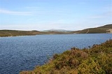
.jpg) Whilst the lake is often regarded in a general sense as the source of the river Conwy, much of this area of the Migneint blanket bog contributes water to its uppermost reaches.
Whilst the lake is often regarded in a general sense as the source of the river Conwy, much of this area of the Migneint blanket bog contributes water to its uppermost reaches.
The lake itself lies in a small basin and is actually fed by a small number of other unnamed streams within the catchment area
, which measures 175ha and ranges in altitude from 435m to 530m. The largest two of these, which enter the lake on its north-western and eastern shores, can be followed for over ¼ mile to the upper edges of the basin, even during drier periods. The heads of these two streams, where the damp ground produces an identifiable flow - at SH774465 on the slopes of Bryn y Bedol, and at SH783467 on the slopes of Pen y Bedw - should perhaps more correctly be regarded as the uppermost sources of the river Conwy.
In times of very heavy rainfall some water is diverted from Cwm Lanerch by means of leats into Llyn Conwy.
.
There are three old huts on the sides of the lake. On the north shore, there is an old boathouse that was struck by lightning and destroyed on 5 July 1881, but was subsequently repaired. On the southern shore there is a more intact boathouse that is still in use today as there is a boat housed inside that was formerly used as a lifeboat. Also to the south of that is an old ruined hut that was formerly used by overnight fishermen as a dwelling place.
The lake has two islands, one just off the eastern shore and more to the south, which is covered up by high water levels during most of the year. The other sits to the north east corner of the lake and has a cairn on it, as well as a reasonably big grassy/rocky area.
, who kept the lake well stocked. Over 2 days in 1880 a party caught 111 trout, and a month later some 119 were caught in the infant river Conwy between the lake and Ysbyty Ifan.
In recent decades, Llyn Conwy has endured a decline in the number of people fishing there; the acidity of the water means that fish
find it harder to live there , however a process of neutralization is underway there as limestone
from the banks of the lake is slowly seeping into the water and levelling the pH
levels so that gradually, over a process of ten years, the water will return to its former condition.
, near Blaenau Ffestiniog
. A right turn from Ffestiniog leads to an old house called 'Llyn Cottage' (often used for night fishing by Lord Penrhyn and his friends), where there is parking and an access path to the lake. It can also be approached from Penmachno
, taking the left hand turn sign posted Ysbyty Ifan
. The path from this point, whilst following a Right of Way, is far less well defined.
The catchment area around the lake, whilst owned by the National Trust, has a tenant farmer and is not Open Access.
, the 18th century Welsh
naturalist
and antiquary, in his Tours of Wales, and by George Borrow
, the traveller and author of Wild Wales
, who passed by in 1854.
In his equally descriptive, though more recent, novel The River Conwy (1952), Wilson MacArthur and his wife Joan follow the course of the river Conwy downstream to the sea, starting from Llyn Conwy.
North Wales
North Wales is the northernmost unofficial region of Wales. It is bordered to the south by the counties of Ceredigion and Powys in Mid Wales and to the east by the counties of Shropshire in the West Midlands and Cheshire in North West England...
Wales
Wales
Wales is a country that is part of the United Kingdom and the island of Great Britain, bordered by England to its east and the Atlantic Ocean and Irish Sea to its west. It has a population of three million, and a total area of 20,779 km²...
. It is the source of the River Conwy
River Conwy
The River Conwy is a river in north Wales. From its source to its discharge in Conwy Bay it is a little over long. "Conwy" is sometimes Anglicized as "Conway."...
which, on flowing south out of the lake, swings round to then generally flow in a northerly direction for a distance of some 27 miles (43.5 km) to its discharge in Conwy Bay
Conwy Bay
Conwy Bay is an inlet of the Irish Sea, defined by the east coast of Anglesey and the north coast of Wales. Puffin Island and the Great Orme mark the limits of the bay....
. Llyn Conwy lies at a height of about 1,488 ft, with a maximum depth of 16 feet, and is by far the biggest lake of the Migneint
Migneint
The Migneint is a large expanse of moorland in central Snowdonia, North Wales. It is part of the Migneint-Arenig-Dduallt Special Area of Conservation, along with the mountains Arenig Fawr, Arenig Fach and Dduallt, covering a range of nearly 200 km²...
moors, an extensive area of blanket mire with high rainfall - about 260 cm p.a.
Geology
This is an area of OrdovicianOrdovician
The Ordovician is a geologic period and system, the second of six of the Paleozoic Era, and covers the time between 488.3±1.7 to 443.7±1.5 million years ago . It follows the Cambrian Period and is followed by the Silurian Period...
rocks, lending its name to the "Llyn Conwy Formation", which is identified by its yellowish rhyolitic tuffs. This Formation also reappears in Afon Tryweryn
Afon Tryweryn
For the flooding of the Tryweryn Valley, see Llyn Celyn.The Tryweryn is a river in north Wales which starts at Llyn Tryweryn in the Snowdonia National Park and after joins the river Dee at Bala. It is one of the main tributaries of the Dee and has been dammed to form Llyn Celyn...
to the south-east, where the hard rock was utilized in the construction of Llyn Celyn
Llyn Celyn
Llyn Celyn is a large reservoir constructed between 1960 and 1965 in the valley of the River Tryweryn in Gwynedd, North Wales. It measures roughly 2½ miles long by a mile wide, and has a maximum depth of...
dam.
Water quality and soil
Llyn Conwy is owned by the National TrustNational Trust for Places of Historic Interest or Natural Beauty
The National Trust for Places of Historic Interest or Natural Beauty, usually known as the National Trust, is a conservation organisation in England, Wales and Northern Ireland...
and, whilst a natural lake, is managed as a reservoir
Reservoir
A reservoir , artificial lake or dam is used to store water.Reservoirs may be created in river valleys by the construction of a dam or may be built by excavation in the ground or by conventional construction techniques such as brickwork or cast concrete.The term reservoir may also be used to...
by Welsh Water
Welsh Water
Dŵr Cymru Welsh Water is a company which supplies drinking water and wastewater services to most of Wales and parts of western England.It is regulated under the Water Industry Act 1991.-History:...
.
It supplies some of the water needs of the upper Conwy Valley, including Betws-y-coed
Betws-y-Coed
Betws-y-Coed is a village and community in the Conwy valley in Conwy County Borough, Wales. It has a population of 534. The name Betws or Bettws is generally thought to be derived from the Anglo-Saxon Old English 'bed-hus' - i.e. a bead-house - a house of prayer, or oratory...
and Llanrwst
Llanrwst
Llanrwst is a small town and community on the A470 road and the River Conwy in Conwy County Borough, Wales. It takes its name from the 5th century to 6th century Saint Grwst, and the original parish church in Cae Llan was replaced by the 12th-century church....
. Contingency plans for drought also name Llyn Conwy as the secondary source in the zone which, along with its own supply area, can feed part of the ‘normal’ Llyn Cowlyd
Llyn Cowlyd
Llyn Cowlyd is the deepest lake in North Wales. It lies in the Snowdonia National Park on the edge of the Carneddau range of mountains, at a height of above sea level. The lake is long and narrow, measuring nearly long and about a third of a mile wide, and covers an area of...
(near Trefriw
Trefriw
Trefriw is a village in Conwy County Borough, Wales. It lies on the river Conwy in North Wales, a few miles south of the site of the Roman fort of Canovium, sited at Caerhun. The parish population in 2001 was 924....
) supply area. A compensation discharge of 0.91 Ml/d would be required from Llyn Conwy.
The pH level of the lake is reported as pH 7.5257 on average, with calcium carbonate rates at 53.7 mg/l, hardness 3 °GH, free chlorine at 0.2853 mg/l and total chlorine at 0.354 mg/l.
In 2008 the National Trust reported that it was working with its tenant farmers to improve water storage in the Welsh uplands. In this area staff are starting to restore the Migneint blanket bog. Drainage ditches are being blocked to help retain water, to reduce erosion, and to cut the amount of peat entering water courses. Work on the wider Ysbyty Estate aims to improve the quality of drinking water from the lake without the need for expensive treatment works, and to retain the Migneint as one of the largest carbon stores in Wales. Peatland restoration can help enhance wildlife habitats and restore species diversity.
This area is very affected by acid rain and the thin peaty soil is best suited for sheep grazing.
Blanket mire is particularly sensitive to climate change
Climate change
Climate change is a significant and lasting change in the statistical distribution of weather patterns over periods ranging from decades to millions of years. It may be a change in average weather conditions or the distribution of events around that average...
and this location has consequently been used on a number of occasions for scientific research.
Source of the river Conwy
The lake itself lies in a small basin and is actually fed by a small number of other unnamed streams within the catchment area
Drainage basin
A drainage basin is an extent or an area of land where surface water from rain and melting snow or ice converges to a single point, usually the exit of the basin, where the waters join another waterbody, such as a river, lake, reservoir, estuary, wetland, sea, or ocean...
, which measures 175ha and ranges in altitude from 435m to 530m. The largest two of these, which enter the lake on its north-western and eastern shores, can be followed for over ¼ mile to the upper edges of the basin, even during drier periods. The heads of these two streams, where the damp ground produces an identifiable flow - at SH774465 on the slopes of Bryn y Bedol, and at SH783467 on the slopes of Pen y Bedw - should perhaps more correctly be regarded as the uppermost sources of the river Conwy.
In times of very heavy rainfall some water is diverted from Cwm Lanerch by means of leats into Llyn Conwy.
Features
A small parapet with a sluice-gate, hardly worthy of the word "dam", controls the outflow from the southern end of the lake, the level of which has not changed since the early 19th century Ordnance SurveyOrdnance Survey
Ordnance Survey , an executive agency and non-ministerial government department of the Government of the United Kingdom, is the national mapping agency for Great Britain, producing maps of Great Britain , and one of the world's largest producers of maps.The name reflects its creation together with...
.
There are three old huts on the sides of the lake. On the north shore, there is an old boathouse that was struck by lightning and destroyed on 5 July 1881, but was subsequently repaired. On the southern shore there is a more intact boathouse that is still in use today as there is a boat housed inside that was formerly used as a lifeboat. Also to the south of that is an old ruined hut that was formerly used by overnight fishermen as a dwelling place.
The lake has two islands, one just off the eastern shore and more to the south, which is covered up by high water levels during most of the year. The other sits to the north east corner of the lake and has a cairn on it, as well as a reasonably big grassy/rocky area.
Fishing
Llyn Conwy was at one time owned and looked after by Lord PenrhynBaron Penrhyn
Baron Penrhyn is a title that has been created twice. The first creation came in the Peerage of Ireland in 1783 in favour of Richard Pennant, who had previously served as a Member of Parliament for Petersfield and Liverpool. This creation became extinct on his death in 1808...
, who kept the lake well stocked. Over 2 days in 1880 a party caught 111 trout, and a month later some 119 were caught in the infant river Conwy between the lake and Ysbyty Ifan.
In recent decades, Llyn Conwy has endured a decline in the number of people fishing there; the acidity of the water means that fish
Fish
Fish are a paraphyletic group of organisms that consist of all gill-bearing aquatic vertebrate animals that lack limbs with digits. Included in this definition are the living hagfish, lampreys, and cartilaginous and bony fish, as well as various extinct related groups...
find it harder to live there , however a process of neutralization is underway there as limestone
Limestone
Limestone is a sedimentary rock composed largely of the minerals calcite and aragonite, which are different crystal forms of calcium carbonate . Many limestones are composed from skeletal fragments of marine organisms such as coral or foraminifera....
from the banks of the lake is slowly seeping into the water and levelling the pH
PH
In chemistry, pH is a measure of the acidity or basicity of an aqueous solution. Pure water is said to be neutral, with a pH close to 7.0 at . Solutions with a pH less than 7 are said to be acidic and solutions with a pH greater than 7 are basic or alkaline...
levels so that gradually, over a process of ten years, the water will return to its former condition.
Access
The easiest access to the lake is from the B4407, which runs from the A5 near Pentrefoelas to FfestiniogFfestiniog
Ffestiniog is a community in Gwynedd in Wales, containing several villages, in particular the settlements of Llan Ffestiniog and Blaenau Ffestiniog. It has a population of 4,830....
, near Blaenau Ffestiniog
Blaenau Ffestiniog
Blaenau Ffestiniog is a town in Gwynedd, north-west Wales. It has a population of 5,000, including Llan Ffestiniog, which makes it the third largest town in Gwynedd, behind Caernarfon & Porthmadog. Although the population reached 12,000 at the peak of the slate industry, the population fell due to...
. A right turn from Ffestiniog leads to an old house called 'Llyn Cottage' (often used for night fishing by Lord Penrhyn and his friends), where there is parking and an access path to the lake. It can also be approached from Penmachno
Penmachno
Penmachno is a village in the isolated upland valley of Cwm Penmachno, 4 miles south of Betws-y-Coed in the county of Conwy, north Wales.It is renowned as the home of Bishop William Morgan , who lived at Tŷ Mawr, Y Wybrnant, near the village. He was one of the leading scholars of his day, having...
, taking the left hand turn sign posted Ysbyty Ifan
Ysbyty Ifan
Ysbyty Ifan is a small but historic village in Conwy County Borough, north Wales. Nearly all the population speak Welsh.-History:Ysbyty Ifan, until 1189, was known as Dôl Gynwal. Then, it came to the attention of the Knights of St John, who set up a hospice...
. The path from this point, whilst following a Right of Way, is far less well defined.
The catchment area around the lake, whilst owned by the National Trust, has a tenant farmer and is not Open Access.
In literature
Llyn Conwy is mentioned both by Thomas PennantThomas Pennant
Thomas Pennant was a Welsh naturalist and antiquary.The Pennants were a Welsh gentry family from the parish of Whitford, Flintshire, who had built up a modest estate at Bychton by the seventeenth century...
, the 18th century Welsh
Wales
Wales is a country that is part of the United Kingdom and the island of Great Britain, bordered by England to its east and the Atlantic Ocean and Irish Sea to its west. It has a population of three million, and a total area of 20,779 km²...
naturalist
Natural history
Natural history is the scientific research of plants or animals, leaning more towards observational rather than experimental methods of study, and encompasses more research published in magazines than in academic journals. Grouped among the natural sciences, natural history is the systematic study...
and antiquary, in his Tours of Wales, and by George Borrow
George Borrow
George Henry Borrow was an English author who wrote novels and travelogues based on his own experiences around Europe. Over the course of his wanderings, he developed a close affinity with the Romani people of Europe. They figure prominently in his work...
, the traveller and author of Wild Wales
Wild Wales
Wild Wales: Its People, Language and Scenery is a travel book by the English Victorian gentleman writer George Borrow, , first published in 1862....
, who passed by in 1854.
In his equally descriptive, though more recent, novel The River Conwy (1952), Wilson MacArthur and his wife Joan follow the course of the river Conwy downstream to the sea, starting from Llyn Conwy.