

Liwa Oasis
Encyclopedia
Oasis
In geography, an oasis or cienega is an isolated area of vegetation in a desert, typically surrounding a spring or similar water source...
area in Abu Dhabi
Abu Dhabi (emirate)
Abu Dhabi, officially the Emirate of Abu Dhabi, , is one of seven emirates that constitute the United Arab Emirates . It is the capital of UAE and is the largest emirate by area , and second-largest by population , accounting for approximately 86% of the total land area of the UAE...
, United Arab Emirates
United Arab Emirates
The United Arab Emirates, abbreviated as the UAE, or shortened to "the Emirates", is a state situated in the southeast of the Arabian Peninsula in Western Asia on the Persian Gulf, bordering Oman, and Saudi Arabia, and sharing sea borders with Iraq, Kuwait, Bahrain, Qatar, and Iran.The UAE is a...
.
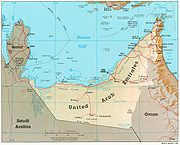
Geography
Liwa Oasis is about 100 km south of the Persian GulfPersian Gulf
The Persian Gulf, in Southwest Asia, is an extension of the Indian Ocean located between Iran and the Arabian Peninsula.The Persian Gulf was the focus of the 1980–1988 Iran-Iraq War, in which each side attacked the other's oil tankers...
coast and 150 km SSW
SSW
SSW is a three-letter abbreviation that may refer to:* South-SouthWest compass direction, see: Boxing the compass* SSW, the callsign of a TV station in the South West and Great Southern regions of Western Australia* St...
of the city of Abu Dhabi
Abu Dhabi
Abu Dhabi , literally Father of Gazelle, is the capital and the second largest city of the United Arab Emirates in terms of population and the largest of the seven member emirates of the United Arab Emirates. Abu Dhabi lies on a T-shaped island jutting into the Persian Gulf from the central western...
, on the northern edge of Rub' al Khali desert
Desert
A desert is a landscape or region that receives an extremely low amount of precipitation, less than enough to support growth of most plants. Most deserts have an average annual precipitation of less than...
. It is centered around 23°08′N 53°46′E and stretches about 100 km east-west, along an arch curved to the north. It consists of some 50 villages. The geographic and economic center of the oasis is Muzayri`, where the highway from Abu Dhabi enters the oasis and then divides to the east (65 km to the easternmost village, Mahdar Bin `Usayyan) and west (45 km to the westernmost village, `Aradah).
There are no statistical data available, but judging from satellite images, the population is estimated at 50,000 to 150,000http://lexicorient.com/e.o/liwa_o.htm.
The villages of Liwa Oasis are the southernmost settlements of Abu Dhabi and of the United Arab Emirates
United Arab Emirates
The United Arab Emirates, abbreviated as the UAE, or shortened to "the Emirates", is a state situated in the southeast of the Arabian Peninsula in Western Asia on the Persian Gulf, bordering Oman, and Saudi Arabia, and sharing sea borders with Iraq, Kuwait, Bahrain, Qatar, and Iran.The UAE is a...
. The southern border of Abu Dhabi with Saudi Arabia
Saudi Arabia
The Kingdom of Saudi Arabia , commonly known in British English as Saudi Arabia and in Arabic as as-Sa‘ūdiyyah , is the largest state in Western Asia by land area, constituting the bulk of the Arabian Peninsula, and the second-largest in the Arab World...
, which runs at a distance between 16 and 35 km to the Oasis, is a straight line in the Rub al Khali desert, which is largely uninhabited. Mahdar Bin `Usayyan is the southermost village of the Emirates, and also the easternmost of the oasis. 10 km south of the border, and 40 km south of the eastern part of the oasis is the Saudi oil facility Shaybah
Shaybah
Shaybah is a major crude oil producing site in Saudi Arabia and is located approximately 40 km from the northern edge of the Rub' Al-Khali/Empty Quarter desert. It is located about 10 km south of the border to Abu Dhabi, United Arab Emirates, which is a straight line drawn in the desert...
. However, there is no road linking Liwa Oasis and Shaybah, and no border crossing.
A modern, multilane highway connects the oasis area to the capital, Abu Dhabi.
Economy
An important traditional branch of the economy is dateDate Palm
The date palm is a palm in the genus Phoenix, cultivated for its edible sweet fruit. Although its place of origin is unknown because of long cultivation, it probably originated from lands around the Persian Gulf. It is a medium-sized plant, 15–25 m tall, growing singly or forming a clump with...
farming. There is a widespread use of drip irrigation
Drip irrigation
Drip irrigation, also known as trickle irrigation or microirrigation or localized irrigation , is an irrigation method which saves water and fertilizer by allowing water to drip slowly to the roots of plants, either onto the soil surface or directly onto the root zone, through a network of valves,...
and greenhouse
Greenhouse
A greenhouse is a building in which plants are grown. These structures range in size from small sheds to very large buildings...
s. The importance of tourism is on the rise. Liwa Hotel in Muzayri` boasts four stars. Liwa Rest House, in the same village and run by the government of Abu Dhabi, is the second establishment in the oasis. It is primarily aimed at minor officials and businessmen. Construction has begun on a third, 5 star, resourt (named Qasr Al Sarab). The nearby Moreeb dune
Moreeb dunes
In the United Arab Emirates, Moreeb dunes is a place for organized drag races. With a reported 50 degree slipface, and height of 120 meters, it is a perfect place for sand drags. Moreeb Hill is supposedly the tallest dune in the UAE, and one of the largest hill climbs in the world.Moreeb Dune is...
22°59′N 53°47′E, 22 km south of Muzayri` on a small road (15 km as the crow flies), with 300 meter height one of the largest dunes in the world, attracts every year during the Liwa festival a large number of international and local visitors coming to see the offroad and camel racing events.
History
The oasis is the place of birth of the ruling families of Abu Dhabi and DubaiDubai
Dubai is a city and emirate in the United Arab Emirates . The emirate is located south of the Persian Gulf on the Arabian Peninsula and has the largest population with the second-largest land territory by area of all the emirates, after Abu Dhabi...
. In 1793, the ruling family Al Nahyan moved their residence from Liwa to the city of Abu Dhabi.
Traditionally, men from Liwa (Bani Yas
Bani Yas
Bani Yas is a tribe in the United Arab Emirates that had a coalition with many other tribes in the region. The tribal coalition which consists of tribes from Dubai to Khawr al Udayd southeast of Qatar, was called the Bani Yas Coalition. The tribe has been led by their rulers the Al Nahyan and their...
tribe) were pearl
Pearl
A pearl is a hard object produced within the soft tissue of a living shelled mollusk. Just like the shell of a mollusk, a pearl is made up of calcium carbonate in minute crystalline form, which has been deposited in concentric layers. The ideal pearl is perfectly round and smooth, but many other...
divers on the coast during the summer months. Pearl diving offered an additional source of income.
Villages
The USGS Geographic Names Databasehttp://earth-info.nga.mil/gns/html/namefiles.htm lists 39 populated places in the area of the oasis, which are listed from west to east in the following table. Some of the more important villages are printed in bold.| Village | Arabic | Coordinates Geographic coordinate system A geographic coordinate system is a coordinate system that enables every location on the Earth to be specified by a set of numbers. The coordinates are often chosen such that one of the numbers represent vertical position, and two or three of the numbers represent horizontal position... |
|---|---|---|
| `Aradah | عرادة | 22°59′00"N 53°26′00"E |
| Milqatah | ملقطة | 23°04′00"N 53°32′00"E |
| Al `Idd | العيد | 23°04′48"N 53°33′02"E |
| Al Mariyah al Gharbiyah | المرية الغربية | 23°06′12"N 53°34′48"E |
| Humar | حمار | 23°05′04"N 53°35′03"E |
| Khannur | خنور | 23°06′14"N 53°36′05"E |
| Hamarur | حمرور | 23°06′00"N 53°36′31"E |
| Taraq | طرق | 23°06′50"N 53°36′41"E |
| Mujib | مجيب | 23°07′00"N 53°41′00"E |
| Kayyah | كية | 23°09′30"N 53°41′05"E |
| Zuwayhir | ظويهر | 23°08′22"N 53°41′36"E |
| Wafd | وفد | 23°06′20"N 53°42′50"E |
| Umm al Qurayn | أم القرين | 23°06′00"N 53°43′00"E |
| Qutuf | قطوف | 23°06′36"N 53°43′29"E |
| Al Atir | العاطر | 23°09′50"N 53°44′07"E |
| Al Mariyah | المارية | 23°08′30"N 53°44′30"E |
| Zafir | ظافر | 23°07′50"N 53°45′37"E |
| Jayf | جيف | 23°09′44"N 53°46′28"E |
| Muzayri` | مظيري | 23°08′19"N 53°47′14"E |
| Nafir | نافر | 23°06′00"N 53°48′00"E |
| Huwaylah | حويلة | 23°09′19"N 53°49′26"E |
| Qurmidah | قرمدة | 23°07′08"N 53°49′42"E |
| Hafif | هفيف \ حفيف | 23°08′52"N 53°50′29"E |
| `Attab | عتاب | 23°09′14"N 53°52′46"E |
| Shah | شاه | 23°08′33"N 53°54′51"E |
| Huwaytayn | حويطين | 23°06′51"N 53°55′52"E |
| Sabkhah | سبخة | 23°07′50"N 53°59′11"E |
| Al Hadhi | الهذي | 23°06′57"N 53°59′48"E |
| Tharwaniyah | ثروانية | 23°05′00"N 54°01′00"E |
| Al Mashrub | المشرب | 23°04′00"N 54°01′00"E |
| An Nashshash | النشاش | 23°05′00"N 54°02′00"E |
| Dahin | داهن | 23°04′00"N 54°05′00"E |
| Wadhil | واظل | 23°03′00"N 54°08′00"E |
| Mawsil | موصل | 23°01′00"N 54°09′00"E |
| Al Khis | الخيس | 23°00′00"N 54°12′00"E |
| Qu`aysah | قويسة | 22°59′00"N 54°14′00"E |
| Hamim | حميم | 22°58′00"N 54°18′00"E |
| Jurayrah | جريرة | 22°57′00"N 54°19′00"E |
| Mahdar Bin `Usayyan | مهدر بن عصيان | 22°56′00"N 54°19′00"E |