
Little Monadnock Mountain
Encyclopedia
- Should not be confused with the nearby Mount MonadnockMount MonadnockMount Monadnock, or Grand Monadnock, is the most prominent New England mountain peak south of the White Mountains and east of the Massachusetts Berkshires, and is the highest point in Cheshire County, New Hampshire...
, the most prominent mountain in southern New Hampshire.
Little Monadnock Mountain, 1900 feet (579 m), is located in the towns of Fitzwilliam
Fitzwilliam, New Hampshire
Fitzwilliam is a town in Cheshire County, New Hampshire, United States. The population was 2,396 at the 2010 census. Fitzwilliam is home to Rhododendron State Park, a grove of native rhododendrons that bloom in mid-July.-History:...
and Troy, New Hampshire
Troy, New Hampshire
Troy is a town in Cheshire County, New Hampshire, United States. The population was 2,145 at the 2010 census. It is situated at the base of Mount Monadnock....
. Most of the mountain is located within Rhododendron State Park
Rhododendron State Park
Rhododendron State Park in Fitzwilliam, New Hampshire, USA, is a state park located on and around Little Monadnock Mountain, containing a stand of native Rhododendron maximum, the largest of nineteen similar stands in central and northern New England, the northern limit of their growing range.The...
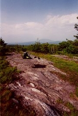
; there are scenic vistas from ledges just below the summit. The 110 mile Metacomet-Monadnock Trail
Metacomet-Monadnock Trail
The Metacomet-Monadnock Trail is a hiking trail that traverses the Metacomet Ridge of the Pioneer Valley region of Massachusetts and the central uplands of Massachusetts and southern New Hampshire...
crosses the mountain.
The mountain is flanked by Gap Mountain
Gap Mountain
Gap Mountain, located in Troy, New Hampshire, is a small monadnock with three summits ranging between and . The lower north and middle summits are mostly bald and offer panoramic views of the surrounding rural landscape and of the higher and more popular Mount Monadnock. The Metacomet-Monadnock...
four miles northeast and by the Franconia Range (not the major ridge in the White Mountains
White Mountains (New Hampshire)
The White Mountains are a mountain range covering about a quarter of the state of New Hampshire and a small portion of western Maine in the United States. Part of the Appalachian Mountains, they are considered the most rugged mountains in New England...
), 4.5 miles to the west; its south and east slopes drain into the Tully River, then to the Millers River
Millers River
The Millers River is a river in northern Massachusetts, originating in Ashburnham and joining the Connecticut River just downstream from Millers Falls, Massachusetts...
, thence to the Connecticut River
Connecticut River
The Connecticut River is the largest and longest river in New England, and also an American Heritage River. It flows roughly south, starting from the Fourth Connecticut Lake in New Hampshire. After flowing through the remaining Connecticut Lakes and Lake Francis, it defines the border between the...
and Long Island Sound
Long Island Sound
Long Island Sound is an estuary of the Atlantic Ocean, located in the United States between Connecticut to the north and Long Island, New York to the south. The mouth of the Connecticut River at Old Saybrook, Connecticut, empties into the sound. On its western end the sound is bounded by the Bronx...
, while its north and west slopes drain into the Ashuelot River
Ashuelot River
The Ashuelot River is a tributary of the Connecticut River, approximately long, in southwestern New Hampshire in the United States. It drains a mountainous area of , including much of the area known as the Monadnock Region...
, thence to the Connecticut River.
Hiking
The summit ledges of Little Monadnock Mountain are accessible via the Metacomet-Monadnock Trail or by the shorter route from the Rhododendron State Park headquarters/trailhead in Fitzwilliam (1.2 mi/1.9 km to the summit). A loop (4.1 mi/6.5 km) via both trails is possible. The mountain is open to hikingHiking
Hiking is an outdoor activity which consists of walking in natural environments, often in mountainous or other scenic terrain. People often hike on hiking trails. It is such a popular activity that there are numerous hiking organizations worldwide. The health benefits of different types of hiking...
, picnicking, and snowshoeing in the winter. Pets are not allowed in Rhododendron State Park.
Conservation

Rhododendron maximum
Rhododendron maximum — also called great rhododendron, great laurel, rosebay rhododendron, American rhododendron or big rhododendron — is a species of Rhododendron native to eastern North America, from Nova Scotia south to northern Alabama.-Description:R. maximum is an evergreen shrub growing to 4...
in northern New England
New England
New England is a region in the northeastern corner of the United States consisting of the six states of Maine, New Hampshire, Vermont, Massachusetts, Rhode Island, and Connecticut...
. The grove has been recognized as a National Natural Landmark
National Natural Landmark
The National Natural Landmark program recognizes and encourages the conservation of outstanding examples of the natural history of the United States. It is the only natural areas program of national scope that identifies and recognizes the best examples of biological and geological features in...
. A loop trail through the grove is accessible from the park trailhead.
In 2000, the Metacomet-Monadnock Trail was included in a study by the National Park Service
National Park Service
The National Park Service is the U.S. federal agency that manages all national parks, many national monuments, and other conservation and historical properties with various title designations...
for possible inclusion in a new National Scenic Trail
National Scenic Trail
National Scenic Trail is a designation for protected areas in the United States that consist of trails of particular natural beauty.National Scenic Trails were authorized under the National Trails System Act of 1968 along with National Historic Trails and National Recreation Trails...
, now tentatively called the New England National Scenic Trail
New England National Scenic Trail
The New England National Scenic Trail is a National Scenic Trail in southern New England, which includes most of the three single trails Metacomet-Monadnock Trail, Mattabesett Trail and Metacomet Trail. After the Metacomet-Monadnock-Mattabesett trail system, the trail is sometimes called Triple-M...
, which would also include the Mattabesett
Mattabesett Trail
The Mattabesett Trail is a long, hook-shaped Blue-Blazed hiking trail in central Connecticut and a part of the newly designated New England National Scenic Trail. One half of the trail follows the high traprock ridges of the Metacomet Ridge, from Totoket Mountain in Guilford, Connecticut to...
and Metacomet
Metacomet Trail
The Metacomet Trail is a Blue-Blazed hiking trail that traverses the Metacomet Ridge of central Connecticut and is a part of the newly designated New England National Scenic Trail. Despite being easily accessible and close to large population centers, the trail is considered remarkably rugged and...
trails in Connecticut
Connecticut
Connecticut is a state in the New England region of the northeastern United States. It is bordered by Rhode Island to the east, Massachusetts to the north, and the state of New York to the west and the south .Connecticut is named for the Connecticut River, the major U.S. river that approximately...
, giving it some of the status accorded to the Appalachian Trail
Appalachian Trail
The Appalachian National Scenic Trail, generally known as the Appalachian Trail or simply the AT, is a marked hiking trail in the eastern United States extending between Springer Mountain in Georgia and Mount Katahdin in Maine. It is approximately long...
. However, there seems to be some uncertainty whether or not the New Hampshire section of the Metacomet-Monadnock Trial will be included in the final National Scenic Trail.