

List of parks in Louisville, Kentucky
Encyclopedia
Following is a list of park
s, forest
s and nature preserves in the metropolitan area
of Louisville, Kentucky
:
 The Frederick Law Olmsted Parks (formerly called the Olmsted Park System) in Louisville was the last of five such systems designed by Frederick Law Olmsted
. All of the parks in this system are managed by Louisville Metro Parks.
Flagship
Other parks
Parkways

Clarksville parks and recreation
Others and state parks
Park
A park is a protected area, in its natural or semi-natural state, or planted, and set aside for human recreation and enjoyment, or for the protection of wildlife or natural habitats. It may consist of rocks, soil, water, flora and fauna and grass areas. Many parks are legally protected by...
s, forest
Forest
A forest, also referred to as a wood or the woods, is an area with a high density of trees. As with cities, depending where you are in the world, what is considered a forest may vary significantly in size and have various classification according to how and what of the forest is composed...
s and nature preserves in the metropolitan area
Louisville metropolitan area
The Louisville-Jefferson County, KY-IN Metropolitan Statistical Area, commonly called the Louisville metropolitan area or Kentuckiana, is the 42nd largest Metropolitan Statistical Area in the United States...
of Louisville, Kentucky
Louisville, Kentucky
Louisville is the largest city in the U.S. state of Kentucky, and the county seat of Jefferson County. Since 2003, the city's borders have been coterminous with those of the county because of a city-county merger. The city's population at the 2010 census was 741,096...
:
Frederick Law Olmsted Parks
Frederick Law Olmsted
Frederick Law Olmsted was an American journalist, social critic, public administrator, and landscape designer. He is popularly considered to be the father of American landscape architecture, although many scholars have bestowed that title upon Andrew Jackson Downing...
. All of the parks in this system are managed by Louisville Metro Parks.
Flagship
- Cherokee ParkCherokee ParkCherokee Park is a municipal park located in Louisville, Kentucky, United States. It was designed, like 18 of Louisville's 123 public parks, by Frederick Law Olmsted, the father of landscape architecture...
- Iroquois ParkIroquois ParkIroquois Park is a 739 acre municipal park in Louisville, Kentucky, United States. It was designed by Frederick Law Olmsted, who also designed Louisville's Cherokee Park and Shawnee Park, at what were then the edges of the city. Located south of downtown, Iroquois Park was promoted as...
- Shawnee ParkShawnee ParkShawnee Park is a municipal park in Louisville, Kentucky. It was designed by Frederick Law Olmsted, who designed 18 of the city's 123 public parks...
Other parks
- Algonquin Park
- Baxter Square
- Bingham Park — Originally known as Clifton Park
- Boone Square
- Central ParkCentral Park, LouisvilleCentral Park is a municipal park maintained by the city of Louisville, Kentucky. Located in the Old Louisville neighborhood, it was first developed for public use in the 1870s and referred to as "DuPont Square" since it was at that time part of the Du Pont family estate.During the Southern...
- Chickasaw ParkChickasaw ParkChickasaw Park is a municipal park in Louisville, Kentucky's west end. It is fronted to the west by the Ohio River. It was formerly the country estate of political boss John Henry Whallen, and began development as a park in 1923, but was not completed until the 1930s...
- Churchill Park
- Elliott Square
- Seneca ParkSeneca ParkSeneca Park was the last park designed by Frederick Law Olmsted in Louisville, Kentucky, United States. The park system in Louisville was the last out of five designed by the Olmsted firm. The park resides in the Louisville neighborhood of Seneca Gardens, Kentucky...
- Shelby Park
- William B. Stansbury Park — Originally known as Third Street Playground
- Tyler Park
- Victory Park
- Wayside Park
- Willow Park — Originally part of the main entrance to Cherokee Park
Parkways
- Algonquin Parkway
- Eastern Parkway
- Northwestern Parkway
- Southern Parkway
- Southwestern Parkway
Other parks managed by Louisville Metro Parks
- 35th Street Park
- Auburndale Park
- Ballard Park
- Eva Bandman Park
- Beargrass Creek Greenway at Irish Hill
- Beechmont Tot Lot
- Bellevue Park
- Berrytown Park
- Black Mudd Park
- Blue Lick Park
- Bradley Park
- Breslin Park
- William Britt Park
- Buechel Park
- California Park
- Camp Taylor Memorial Park
- Cane Run Park
- Caperton Swamp
- Castlewood Open Space
- George Rogers ClarkGeorge Rogers ClarkGeorge Rogers Clark was a soldier from Virginia and the highest ranking American military officer on the northwestern frontier during the American Revolutionary War. He served as leader of the Kentucky militia throughout much of the war...
Park - Cliff Park
- Clifton Park
- Carrie Gaulbert Cox Park
- Joe CreasonJoe CreasonJoe Creason was a famous journalist who wrote for The Courier-Journal in Louisville, Kentucky.He was born in Benton, Kentucky, which he would later humorously call "the only town in Kentucky where I was born." After graduation from the University of Kentucky in 1940, he became the editor of a...
Park - Crescent Hill Park
- Crosby Park
- Des Pres Park
- Douglass Park
- Dumeyer Park
- Eastover Park
- Eastwood Park
- Fairmount Falls Park
- Farman Park
- Farnsley Park
- Fern Creek Park
- Fisherman's Park
- Flaget Field Park
- Floyd's Fork Park
- German-Paristown Park
- Gnadinger ParkGnadinger ParkGnadinger Park is the smallest public park in Louisville, Kentucky. It is located in the Germantown neighborhood at the intersection of Reutlinger and Ellison Avenues. The park property was donated to the City of Louisville and dedicated as a park on August 9, 1976. It is registered as being just...
- William Harrison Park
- Highview Park
- Nelson Hornbeck Park
- Hounz Lane Park
- Irish Hill Park
- Louis B. Israel Park
- Ivy Court Park
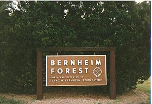
- Jefferson Memorial ForestJefferson Memorial ForestThe Jefferson Memorial Forest is a forest located in southwest Louisville, Kentucky , in the knobs region of Kentucky. At , it is the largest municipal urban forest in the United States...
— Largest municipal urban forestUrban forestAn urban forest is a forest or a collection of trees that grow within a city, town or a suburb. In a wider sense it may include any kind of woody plant vegetation growing in and around human settlements. In a narrower sense it describes areas whose ecosystems are inherited from wilderness...
in the U.S., operated as a park by Metro Parks - Kennedy Court Park
- Hays Kennedy Park
- Klondike Park
- Kulmer Reserve
- Lake Dreamland Park
- Lampton Park
- Lannan Park
- LaPorte Park
- Russell Lee Park
- Liberty Bell Playground
- Locust GroveHistoric Locust GroveHistoric Locust Grove is a 55-acre 18th century farm site and National Historic Landmark situated in eastern Jefferson County, Kentucky . The site is presently owned by the Louisville Metro government, and operated as a historic interpretive site by Historic Locust Grove, Inc.The main feature on...
— Historic home and residence of George Rogers ClarkGeorge Rogers ClarkGeorge Rogers Clark was a soldier from Virginia and the highest ranking American military officer on the northwestern frontier during the American Revolutionary War. He served as leader of the Kentucky militia throughout much of the war... - Long Run Park
- Louisville Extreme ParkLouisville Extreme ParkThe Louisville Extreme Park is a 40,000 square foot public skatepark located in downtown Louisville, Kentucky. It opened on April 5, 2002, and gained national recognition after the release of Tony Hawk's Secret Skatepark Tour, in which the park was featured. The park is open from 6 A.M. to 11 P.M...
- Louisville Champions Park (Future)
- Magnolia Park
- McNeely Lake Park
- Medora Park
- Memorial Park
- William F. Miles Park
- G.G. Moore Park
- Nightingale Park
- Norfolk Acres Park
- Okolona Park
- Old Walnut/Beecher Park
- Parkhill Park
- Patterson Playground
- PeeWee Park
- Petersburg Park
- Portland Park
- Portland Wharf Park
- Huston Quin Park
- Ginny Reichard Park
- Riverside Gardens Park
- Riverside, The Farnsley-Moremen LandingRiverside, The Farnsley-Moremen LandingRiverside, The Farnsley-Moremen Landing is a historic 300 acre farm and house in Southwest Louisville, Kentucky along the banks of the Ohio River...
— Historic home and river landing - Riverview Park
- Roberson Run Park
- Rubel Park
- A.B. Sawyer Park
- Sheppard Park
- Slevin Park
- South Central Park
- St. Louis Park
- Story Avenue Park
- Sun Valley Park
- Sylvania Park
- E. Leland Taylor (Jewell) Park
- Thurman Hutchins Park
- Toonerville Trolley Park
- Twin Park
- Charlie Vettiner Park
- Ben Washer Park
- Watterson Lake Park
- Waverly Park — Includes the 9-hole Bobby NicholsBobby NicholsRobert Herman Nichols is an American professional golfer, best known for winning the 1964 PGA Championship.Nichols was born in Louisville, Kentucky. He attended St. Xavier High School in Louisville and later played golf at Texas A&M University were his team won the Southwest Conference Championship...
Golf Course - Westonia Park
- Wyandotte Park
- Charles Young Park
Parks not managed by Louisville Metro Parks
- Auburn Park (JeffersontownJeffersontown, KentuckyJeffersontown is a city in Jefferson County, Kentucky, United States. Before Louisville and Jefferson County were consolidated in 2003, it was the county's largest city outside of Louisville. The population was 26,633 at the 2000 census.- History :...
) - Beargrass Creek State Nature PreserveBeargrass Creek State Nature PreserveBeargrass Creek State Nature Preserve is a nature preserve in Louisville, Kentucky's Poplar Level neighborhood, in roughly the central portion of the city. It is named for Beargrass Creek, the south fork of which passes along the northern side of the preserve. The preserve is adjacent to...
- Blackacre Nature Preserve and Historic Homestead
- Bowling Park (St. MatthewsSt. Matthews, KentuckySt. Matthews is the 20th largest city in Kentucky, United States and is a prominent suburb of Louisville. It is located 8 miles east of downtown Louisville in Jefferson County. It is one of the state's major shopping areas, being home to second and fifth largest malls in Kentucky St. Matthews is...
) - Brown Park (St. Matthews)
- Dayton Avenue Park (St. Matthews)
- Arthur K. Draut Park (St. Matthews)
- Fort Nelson ParkFort Nelson (Kentucky)Fort Nelson, built in 1781 by Richard Chenoweth, was the second on-shore fort on the Ohio River in the area of what is now downtown Louisville, Kentucky. Fort-on-Shore, the downriver and first on-shore fort, had proved to be insufficient barely three years after it was established...
- Founder's Square
- Garvin Brown Nature Preserve
- Jefferson Square
- Louisville Waterfront ParkLouisville Waterfront ParkLouisville Waterfront Park is a municipal park adjacent to the downtown area of Louisville, Kentucky and the Ohio River. Specifically, it is adjacent to Louisville's wharf and Riverfront Plaza/Belvedere, which are situated to the west of the park....
- Riverfront Plaza/BelvedereRiverfront Plaza/BelvedereRiverfront Plaza/Belvedere is a public area on the Ohio River in Downtown Louisville, Kentucky, USA. Although proposed as early as 1930, the project did not get off the ground until $13.5 million in funding was secured in 1969 to revitalize the downtown area . On April 27, 1973 the Riverfront...
- Robison Park (LyndonLyndon, KentuckyThere were 4,520 households out of which 21.9% had children under the age of 18 living with them, 37.5% were married couples living together, 8.9% had a female householder with no husband present, and 50.3% were non-families. 40.1% of all households were made up of individuals and 7.4% had someone...
) - St. Matthews Park/Community Center
- E. P. "Tom" Sawyer State Park
- Shively Park (ShivelyShively, KentuckyShively is a city in Jefferson County, Kentucky, United States. The population was 15,157 at the 2000 census. It is located southwest of Louisville, Kentucky and directly adjoins the larger city. Shively is centered around the junction of US 60 and the Dixie Highway.-History:Shively was first...
) - Six Mile Island State Nature PreserveSix Mile Island State Nature PreserveSix Mile Island is a nature preserve in Jefferson County, Kentucky located on the Ohio River.-About:The Kentucky State Nature Preserves Commission is the project manager over the preserve and was dedicated June 24, 1979. The reserve is an undeveloped riverine island and is known for its extensive...
- Skyview Park (Jeffersontown)
- Veterans Memorial Park (Jeffersontown)
- Warwick Park (St. Matthews)
Kentucky metropolitan counties outside of Jefferson
Meade
- Otter Creek Outdoor Recreation Area — Operated by the Kentucky Department of Fish and Wildlife Resources
Oldham
- John T. Walsh Park (La GrangeLa Grange, KentuckyAs of the census of 2000, there were 5,676 people, 2,216 households, and 1,502 families residing in the city. The population density was 1,514.8 people per square mile . There were 2,330 housing units at an average density of 621.8 per square mile...
) - Wendell Moore Park (BucknerBuckner, KentuckyBuckner is a census-designated place in Oldham County, Kentucky, United States. The population was 4,000 at the 2000 census.Oldham County High School is located in Buckner.-Geography:Buckner is located at ....
) - Wilborn Park (La Grange)
- Yew Dell Gardens (CrestwoodCrestwood, KentuckyCrestwood is a city in Oldham County, Kentucky, United States just outside of Louisville, Ky's Northeast End. The population was 1,999 at the 2000 census. CNN listed it as the 52nd best place to live in America in 2005...
) - Creasy Mahan Nature Preserve (GoshenGoshen, KentuckyGoshen is a city in Oldham County, Kentucky, United States. The population was 907 at the 2000 census.-Geography:Nestled along the banks of the Ohio River, Goshen is located at ....
) - Community Convention and Aquatic Center (Buckner)
Spencer
- Taylorsville Lake State ParkTaylorsville Lake State ParkTaylorsville Lake State Park is a park encompassing in Spencer County, Kentucky, roughly between Louisville and Lexington. Taylorsville Lake, its major feature, extends into parts of Anderson County and Nelson County....
— includes Taylorsville LakeTaylorsville LakeTaylorsville Lake is a artificial lake or reservoir located mainly in Spencer County, Kentucky. Construction by the United States Army Corps of Engineers started in 1974, and flooding began in 1983...
, which extends into NelsonNelson County, KentuckyNelson County is a county located in the U.S. state of Kentucky. As of 2010, the population was 43,437. Its county seat is Bardstown. The county is part of the Louisville/Jefferson County, KY–IN Metropolitan Statistical Area.- History :...
and AndersonAnderson County, KentuckyAnderson County is a county located in the U.S. state of Kentucky. It was formed in 1827. In 2010 the population was 21,421. Its county seat is Lawrenceburg, Kentucky. The county is named for Richard Clough Anderson, Jr., a Kentucky Legislator, U.S...
Counties.
Indiana metropolitan counties
Clark
Jeffersonville parks and recreation- Bob Hedge Park
- Colston Park
- Connie Seller Park
- Highland Park
- John Wilcoxson Park
- Lansden Park
- Lottie Oglesby Park
- Meijer Little League Fields
- Oak Park
- Optimist Park
- Port Fulton Park
- Shannon Memorial Park
- Shirley Hall Park
- Vissing Park
- Warder ParkWarder ParkWarder Park is located in Jeffersonville, Indiana on Court Avenue. This park has been a part of the community since the mid-19th century, when it had a bakery to produce hardtack to Union soldiers during the American Civil War. The park wasn't established officially until the year 1881 and is named...
- Wathen Park
Clarksville parks and recreation
- Ashland Park
- Beechwood Park
- Cedar Park
- Colgate Park
- Gaskell Park
- Lapping ParkLapping ParkLapping Memorial Park is a park located in the town of Clarksville, Indiana. The park is a park that features play grounds, softball fields, golf, tennis courts, basketball courts, volleyball space, horseshoe pits, amphitheater, lodge, shelter house, and three hiking trails immersed in a thick...
- Little League Park
- Midway Park
- Moser Park
- Parkwood Park
- Ray Lawrence Park
Others and state parks
- Perrin Park — Privately owned; located in Jeffersonville
- Charlestown State ParkCharlestown State ParkCharlestown State Park is an Indiana state park on in Clark County, Indiana, in the United States. The park is on the banks of the Ohio River, east of Charlestown. It was once part of the Indiana Army Ammunition Plant , and was donated in separate parcels to the Indiana state government. In...
- Clark State ForestClark State ForestClark State Forest, located just north of Henryville, Indiana in the United States, is Indiana's oldest state forest, formed in 1903 as a forest research facility and a nursery and later expanded by the Works Progress Administration. Originally 2,028 acres of total land area, it is now almost...
- Falls of the Ohio State ParkFalls of the Ohio State ParkFalls of the Ohio State Park is a state park in Indiana. It is located on the banks of the Ohio River at Clarksville, Indiana, across from Louisville, Kentucky.The park is part of the Falls of the Ohio National Wildlife Conservation Area...
See also
- City of ParksCity of ParksCity of Parks is a municipal project to create a continuous paved pedestrian and biking trail around the city of Louisville, Kentucky while also adding a large amount of park land. The project was announced on February 22, 2005...
- Cityscape of Louisville, KentuckyCityscape of Louisville, KentuckyLouisville, Kentucky is home to numerous structures that are noteworthy due to their architectural characteristics or historic associations, the most noteworthy being the Old Louisville neighborhood, the third largest historic preservation district in the United States...
- Geography of Louisville, KentuckyGeography of Louisville, KentuckyLouisville is a city in Jefferson County, Kentucky. It is located at the Falls of the Ohio River.Louisville is located at . According to the U.S. Census Bureau, Louisville Metro has a total area of 1,032 km²...
- List of attractions and events in Louisville, Kentucky
- Louisville neighborhoodsLouisville neighborhoodsThis is a list of official neighborhoods in Louisville, Kentucky. Like many older American cities, Louisville has well-defined neighborhoods, many with well over a century of history as a neighborhood....
- Louisville ZooLouisville ZooFounded in 1969, the Louisville Zoo, or the Louisville Zoological Garden, is a zoo in Louisville, Kentucky, situated in the city's Poplar Level neighborhood...
External links
- Louisville Metro Parks
- Olmsted Parks Conservancy
- Louisville Parks and Parkways System — The Cultural Landscape Foundation
- City Shaping: The Olmsteds & Louisville — Interactive documentary from The Cultural Landscape Foundation
- Oldham County Parks
- Jeffersonville Parks and Recreation
- Clarksville Parks & Recreation
- Shelby County Parks & Recreation