

Geography of Louisville, Kentucky
Encyclopedia
Louisville, Kentucky
Louisville is the largest city in the U.S. state of Kentucky, and the county seat of Jefferson County. Since 2003, the city's borders have been coterminous with those of the county because of a city-county merger. The city's population at the 2010 census was 741,096...
is a city in Jefferson County
Jefferson County, Kentucky
As of the census of 2000, there were 693,604 people, 287,012 households, and 183,113 families residing in the county. The population density was . There were 305,835 housing units at an average density of...
, Kentucky
Kentucky
The Commonwealth of Kentucky is a state located in the East Central United States of America. As classified by the United States Census Bureau, Kentucky is a Southern state, more specifically in the East South Central region. Kentucky is one of four U.S. states constituted as a commonwealth...
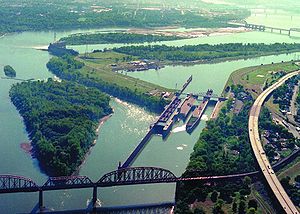
. It is located at the Falls of the Ohio River
Falls of the Ohio National Wildlife Conservation Area
The Falls of the Ohio National Wildlife Conservation Area is a national, bi-state area on the Ohio River near Louisville, Kentucky in the United States, administered by the U.S. Army Corps of Engineers. Federal status was awarded in 1981.- Overview :...
.
Louisville is located at 38°13′44"N 85°44′58"W (38.228870, -85.749534). According to the U.S. Census Bureau
United States Census Bureau
The United States Census Bureau is the government agency that is responsible for the United States Census. It also gathers other national demographic and economic data...
, Louisville Metro (in 2000 measurements for Jefferson County) has a total area of 1,032 km² (399 mi²). 997 km² (385 mi²) of it is land and 35 km² (13 mi²) of it (3.38%) is water.
Topography and geomorphology

Bluegrass region
The Bluegrass Region is a geographic region in the state of Kentucky, United States. It occupies the northern part of the state and since European settlement has contained a majority of the state's population and its largest cities....
, the city's landscape is better described as being in a very wide part of the Ohio River
Ohio River
The Ohio River is the largest tributary, by volume, of the Mississippi River. At the confluence, the Ohio is even bigger than the Mississippi and, thus, is hydrologically the main stream of the whole river system, including the Allegheny River further upstream...
flood plain. Louisville's part of the valley is located between two plateaus, the karst plateau
Karst topography
Karst topography is a geologic formation shaped by the dissolution of a layer or layers of soluble bedrock, usually carbonate rock such as limestone or dolomite, but has also been documented for weathering resistant rocks like quartzite given the right conditions.Due to subterranean drainage, there...
of Southern Indiana
Southern Indiana
Southern Indiana, in the United States, consists of the 33 counties located in the southernmost part of the state. The region's history and geography has led to a blend of Northern and Southern culture distinct from the remainder of Indiana. It is often considered to be part of the Upland South...
and the Bluegrass plateau of Kentucky, both with an elevation of around 900 feet. Elevations drop off the Indiana plateau very sharply via the Muldraugh Escarpment
Muldraugh Hill
Muldraugh Hill is an escarpment in central Kentucky separating the Bluegrass on the north and north-east from the Pennyrile on the south and south-west...
, whereas the rise in elevation up to the Bluegrass plateau is done more gradually.
The flood plain is much longer north to south than it is east to west. For example, within several miles of downtown, the Highlands
The Highlands (Louisville)
The Highlands is an area of Louisville, Kentucky which contains a high density of nightclubs, eclectic businesses, and many upscale and fast food restaurants. It is centered along a three-mile stretch of Bardstown Road and Baxter Avenue and is so named because it sits atop a ridge between the...
sitting at 540 feet is out of the thousand year flood plain, whereas areas 10 miles from downtown such as Fairdale and Okolona (both between seven and 11 miles from the river) have the same elevation as downtown Louisville. Most areas in the east end have an elevation from 600 to 700 feet, which, with the typically east bound winds, trap in heat and pollutants.
Areas along and west of the south fork of Beargrass Creek
Beargrass Creek
Beargrass Creek is the name given to several forks of a creek in Jefferson County, Kentucky. The Beargrass Creek watershed is the largest in the county, draining over ....
(and more generally, I-65
Interstate 65
Interstate 65 is a major Interstate Highway in the United States. The southern terminus is located at an intersection with Interstate 10 in Mobile, Alabama, and its northern terminus is at an interchange with Interstate 90 , U.S. Route 12, and U.S...
) are located where the Ohio River once ran, so the land here is very flat and is composed of harder rocks. Prior to urbanization much of this area was composed of wetlands—early roads through it were laid over wooden planks. This history is occasionally still readily evident in street name
Street name
A street name or odonym is an identifying name given to a street. The street name usually forms part of the address...
s, for example the spoke road Poplar Level
Poplar Level
Poplar Level is a neighborhood five miles southeast of downtown Louisville, Kentucky, USA. It is part of the larger Camp Zachary Taylor area....
, whose name describes its original construction on planks of poplar
Poplar
Populus is a genus of 25–35 species of deciduous flowering plants in the family Salicaceae, native to most of the Northern Hemisphere. English names variously applied to different species include poplar , aspen, and cottonwood....
. 3rd Street was formerly called Central Plank Road
Plank road
A plank road or puncheon is a dirt path or road covered with a series of planks, similar to the wooden sidewalks one would see in a Western movie. Plank roads were very popular in Ontario, the U.S. Northeast and U.S. Midwest in the first half of the 19th century...
for the same reason. As industry, namely Standiford Field airport
Louisville International Airport
Louisville International Airport is a joint civil-military public airport centrally located in the city of Louisville in Jefferson County, Kentucky, USA. The airport covers 1,200 acres and has three runways. Its IATA airport code SDF is based on the airport's former name, Standiford Field...
, moved into the area in the 1950s most creeks through the area were rerouted into ditches to alleviate the area's poor drainage and constant flooding.
Areas east of I-65 were generally not in the flood plain and thus are mostly gentle rollings hills composed of soft loess
Loess
Loess is an aeolian sediment formed by the accumulation of wind-blown silt, typically in the 20–50 micrometre size range, twenty percent or less clay and the balance equal parts sand and silt that are loosely cemented by calcium carbonate...
soils, hence the reason roads here (such as Eastern Parkway) are very prone to potholes. The southern quarter of Jefferson County is in the scenic and rugged Knobs region
Knobs region
The Knobs Region is located in the US state of Kentucky. It is a narrow, horseshoe shaped region consisting of hundreds of isolated hills. The region wraps around the bluegrass region in the center of the state...
. This is the only part of Jefferson County to not have experienced any urbanization and is today almost entirely parkland for the Jefferson Memorial Forest
Jefferson Memorial Forest
The Jefferson Memorial Forest is a forest located in southwest Louisville, Kentucky , in the knobs region of Kentucky. At , it is the largest municipal urban forest in the United States...
. The eastern third is in the Eden Shale Hills
Eden Shale Hills
Eden Shale Hills of the Eden Shale soil type is a broad area of short, steep hills roughly separating the Inner Bluegrass region and Outer Bluegrass region of Kentucky. They occur generally from around Oldham County in the West to Fleming County in the East. The hills are 150 feet or less in height....
section of the Bluegrass region and has also experienced less urbanization than the flood plain, although that is starting to change.
Political geography and population

Jefferson County, Kentucky
As of the census of 2000, there were 693,604 people, 287,012 households, and 183,113 families residing in the county. The population density was . There were 305,835 housing units at an average density of...
(contiguous with Louisville Metro), Bullitt
Bullitt County, Kentucky
As of the census of 2000, there were 61,236 people, 22,171 households, and 17,736 families residing in the county. The population density was . There were 23,160 housing units at an average density of...
, Henry
Henry County, Kentucky
As of the census of 2000, there were 15,060 people, 5,844 households, and 4,330 families residing in the county. The population density was . There were 6,381 housing units at an average density of...
, Meade
Meade County, Kentucky
As of the census of 2000, there were 26,349 people, 9,470 households, and 7,396 families residing in the county. The population density was . There were 10,293 housing units at an average density of...
, Nelson
Nelson County, Kentucky
Nelson County is a county located in the U.S. state of Kentucky. As of 2010, the population was 43,437. Its county seat is Bardstown. The county is part of the Louisville/Jefferson County, KY–IN Metropolitan Statistical Area.- History :...
, Oldham
Oldham County, Kentucky
As of the census of 2000, there were 46,178 people, 14,856 households, and 12,196 families residing in the county. The population density was . There were 15,541 housing units at an average density of...
, Shelby
Shelby County, Kentucky
Shelby County is a county located in the U.S. state of Kentucky. As of 2010, the population was 42,074. Its name is in honor of Isaac Shelby, the first Governor of Kentucky. Its county seat is Shelbyville...
, Spencer
Spencer County, Kentucky
As of the census of 2000, there were 11,766 people, 4,251 households, and 3,358 families residing in the county. The population density was . There were 4,555 housing units at an average density of . The racial makeup of the county was 97.50% White, 1.13% Black or African American, 0.22% Native...
and Trimble
Trimble County, Kentucky
Trimble County is a county located in the U.S. state of Kentucky. As of 2000, the population was 8,125. Its county seat is Bedford. The county is named for Robert Trimble. Trimble is a prohibition or dry county. It is part of the Louisville/Jefferson County, KY–IN Metropolitan Statistical...
. The southern Indiana
Indiana
Indiana is a US state, admitted to the United States as the 19th on December 11, 1816. It is located in the Midwestern United States and Great Lakes Region. With 6,483,802 residents, the state is ranked 15th in population and 16th in population density. Indiana is ranked 38th in land area and is...
counties Clark
Clark County, Indiana
Clark County is a county located in the U.S. state of Indiana, located directly across the Ohio River from Louisville, Kentucky. At the 2010 Census, the population was 110,232. The county seat is Jeffersonville. Clarksville is also a major city in the county...
, Floyd
Floyd County, Indiana
Floyd County is a county located in the U.S. state of Indiana. As of 2010, the population was 74,578. The county seat is New Albany. Floyd County is the county with the second smallest land area in the entire state...
, Harrison
Harrison County, Indiana
Harrison County is a county located in the far southern part of the U.S. state of Indiana along the Ohio River. It is divided into twelve townships, and the county seat is Corydon, the former capital of Indiana. The county is part of the larger Louisville/Jefferson County, KY–IN Metropolitan...
and Washington
Washington County, Indiana
Washington County is a county located in the U.S. state of Indiana. As of 2010, the population was 28,262. The county seat is Salem.Washington County is part of the Louisville/Jefferson County, KY–IN Metropolitan Statistical Area.-Early settlers:...
are also included in the Louisville MSA
United States metropolitan area
In the United States a metropolitan statistical area is a geographical region with a relatively high population density at its core and close economic ties throughout the area. Such regions are not legally incorporated as a city or town would be, nor are they legal administrative divisions like...
. This MSA is included in the Louisville-Elizabethtown-Scottsburg, KY-IN Combined Statistical Area (CSA), which also includes the Elizabethtown, KY
Elizabethtown, Kentucky
Elizabethtown is a city in and the county seat of Hardin County, Kentucky, United States. The population was 28,531 at the 2010 census, making it the eleventh-largest city in the state...
MSA (composed of Hardin
Hardin County, Kentucky
As of the census of 2000, there were 94,174 people, 34,497 households, and 25,355 families residing in the county. The population density was . There were 37,673 housing units at an average density of...
and Larue
LaRue County, Kentucky
LaRue County is a county located in the U.S. state of Kentucky. It is included in the Elizabethtown, Kentucky, Metropolitan Statistical Area. As of 2000, the population was 13,373. Its county seat is Hodgenville...
Counties) as well as the Scottsburg, IN
Scottsburg, Indiana
Scottsburg is a city in Vienna Township, Scott County, Indiana, United States, about north of Louisville, Kentucky. The population was 6,747 at the 2010 census. The city is the county seat of Scott County. As of 2010, William H...
Micropolitan Statistical Area
United States micropolitan area
United States Micropolitan Statistical Areas , as defined by the United States Office of Management and Budget, are urban areas in the United States based around a core city or town with a population of 10,000 to 49,999. The micropolitan area designation was created in 2003...
.
Louisville's Metro Area was expanded more than any other in the country during a March 2003 overhaul of U.S. Metropolitan Area statistics by the federal government. In the 2000 census, even very fast growing counties such as Spencer County
Spencer County, Kentucky
As of the census of 2000, there were 11,766 people, 4,251 households, and 3,358 families residing in the county. The population density was . There were 4,555 housing units at an average density of . The racial makeup of the county was 97.50% White, 1.13% Black or African American, 0.22% Native...
weren't included. The Metro Area's ranking rose from 49th to 42nd, and the added Combined Statistical Area measured the area as the nation's 31st largest. The total Metro area population also increased dramatically from just over 1 million to nearly 1.4 for the CSA.
17% of the state's population lives in Jefferson County and 25% live in counties in the Louisville CSA, and also Jefferson County has 2.5 times more people than Kentucky's second most populous county, Fayette County. 12 of the 15 buildings in Kentucky over 300 feet are located in Downtown Louisville
Downtown Louisville
Downtown Louisville is the largest central business district in the Commonwealth of Kentucky and the urban hub of the Louisville, Kentucky Metropolitan Area. Its boundaries are the Ohio River to the north, Hancock Street to the east, York and Jacob Streets to the south, and 9th Street to the west...
. Almost 40% of the population growth in Kentucky are in Louisville's CSA counties.
Climate
Louisville is located on the northern limit of the humid subtropical climateHumid subtropical climate
A humid subtropical climate is a climate zone characterized by hot, humid summers and mild to cool winters...
(Köppen
Köppen climate classification
The Köppen climate classification is one of the most widely used climate classification systems. It was first published by Crimea German climatologist Wladimir Köppen in 1884, with several later modifications by Köppen himself, notably in 1918 and 1936...
Cfa). Summer
Summer
Summer is the warmest of the four temperate seasons, between spring and autumn. At the summer solstice, the days are longest and the nights are shortest, with day-length decreasing as the season progresses after the solstice...
s are hot and humid with mildly warm evenings. The mean annual temperature is 56.9 °F (13.8 °C), with an average annual snowfall of 14.7 inches (37 cm) and an average annual rainfall of 44.53 inches (1,131.1 mm). The wettest seasons are the spring
Spring (season)
Spring is one of the four temperate seasons, the transition period between winter and summer. Spring and "springtime" refer to the season, and broadly to ideas of rebirth, renewal and regrowth. The specific definition of the exact timing of "spring" varies according to local climate, cultures and...
and summer, although rainfall is fairly constant all year round. During the winter
Winter
Winter is the coldest season of the year in temperate climates, between autumn and spring. At the winter solstice, the days are shortest and the nights are longest, with days lengthening as the season progresses after the solstice.-Meteorology:...
, particularly in January and February, several days of snow
Snow
Snow is a form of precipitation within the Earth's atmosphere in the form of crystalline water ice, consisting of a multitude of snowflakes that fall from clouds. Since snow is composed of small ice particles, it is a granular material. It has an open and therefore soft structure, unless packed by...
can be expected, allowing for winter sports. January is the coldest month with average highs of 41 °F (5 °C) and average lows of 24.9 °F (-3.9 °C) and July the hottest month with average high and low temperatures of 87 °F (30.6 °C) and 69.8 °F (21 °C). The highest recorded temperature was 107 °F (42 °C) on July 14, 1936, and the lowest recorded temperature was -22 F on January 19, 1994. However, in any season, temperatures can vary widely day by day, because of Louisville's location where many fronts often converge. Severe weather
Severe weather
Severe weather phenomena are weather conditions that are hazardous to human life and property.- Examples Include :Severe weather can occur under a variety of situations, but three characteristics are generally needed: a temperature or moisture boundary, moisture, and , instability in the...
is not uncommon; the area is prone to almost all types of non-tropical weather extremes, including tornado
Tornado
A tornado is a violent, dangerous, rotating column of air that is in contact with both the surface of the earth and a cumulonimbus cloud or, in rare cases, the base of a cumulus cloud. They are often referred to as a twister or a cyclone, although the word cyclone is used in meteorology in a wider...
es, severe thunderstorms, ice storm
Ice storm
An ice storm is a type of winter storm characterized by freezing rain, also known as a glaze event or in some parts of the United States as a silver thaw. The U.S. National Weather Service defines an ice storm as a storm which results in the accumulation of at least of ice on exposed surfaces...
s and extreme heat and cold.
Much like the San Fernando Valley
San Fernando Valley
The San Fernando Valley is an urbanized valley located in the Los Angeles metropolitan area of southern California, United States, defined by the dramatic mountains of the Transverse Ranges circling it...
in Los Angeles
Los Ángeles
Los Ángeles is the capital of the province of Biobío, in the commune of the same name, in Region VIII , in the center-south of Chile. It is located between the Laja and Biobío rivers. The population is 123,445 inhabitants...
, Louisville's Ohio River
Ohio River
The Ohio River is the largest tributary, by volume, of the Mississippi River. At the confluence, the Ohio is even bigger than the Mississippi and, thus, is hydrologically the main stream of the whole river system, including the Allegheny River further upstream...
Valley location traps air pollution
Air pollution
Air pollution is the introduction of chemicals, particulate matter, or biological materials that cause harm or discomfort to humans or other living organisms, or cause damage to the natural environment or built environment, into the atmosphere....
. The city is ranked by Environmental Defense
Environmental Defense
Environmental Defense Fund or EDF is a United States–based nonprofit environmental advocacy group. The group is known for its work on issues including global warming, ecosystem restoration, oceans, and human health...
as America's 38th worst city for air quality. Louisville also often exemplifies the heat island effect
Urban heat island
An urban heat island is a metropolitan area which is significantly warmer than its surrounding rural areas. The phenomenon was first investigated and described by Luke Howard in the 1810s, although he was not the one to name the phenomenon. The temperature difference usually is larger at night...
. Temperatures in commercial areas and in the industrialized areas along interstates are often higher than in the suburbs, particularly the shaded areas, like Anchorage
Anchorage, Kentucky
As of the census of 2000, there were 2,264 people, 729 households, and 643 families residing in the city. The population density was 744.0 people per square mile . There were 750 housing units at an average density of 246.5 per square mile...
, where temperatures are often five degrees cooler.
Louisville's lowest solar noon is 28.4 degrees with the shortest daylength being 9 hours and 30 seconds, both occurring from December 17–26. The city's highest solar noon is 75.2 degrees with the longest daylength being 14 hours and 39 seconds, both occurring from June 17–25. The city's March and September equinox occurs at 50.5 degrees.
External links
- Louisville/Jefferson County Information Consortium
- Metro Mapper - Interactive Maps for the Louisville Metro Area
- Historic Maps of Louisville/Jefferson County, Kentucky — University of LouisvilleUniversity of LouisvilleThe University of Louisville is a public university in Louisville, Kentucky. When founded in 1798, it was the first city-owned public university in the United States and one of the first universities chartered west of the Allegheny Mountains. The university is mandated by the Kentucky General...
libraries