

List of forests in Israel
Encyclopedia
Forest
A forest, also referred to as a wood or the woods, is an area with a high density of trees. As with cities, depending where you are in the world, what is considered a forest may vary significantly in size and have various classification according to how and what of the forest is composed...
s in Israel
Israel
The State of Israel is a parliamentary republic located in the Middle East, along the eastern shore of the Mediterranean Sea...
by region. The forests of contemporary Israel are mainly the result of a massive afforestation campaign by the Jewish National Fund
Jewish National Fund
The Jewish National Fund was founded in 1901 to buy and develop land in Ottoman Palestine for Jewish settlement. The JNF is a quasi-governmental, non-profit organisation...
.
Jerusalem DistrictJerusalem DistrictThe Jerusalem District is one of six administrative districts of Israel. The district capital is Jerusalem. The Jerusalem District has a land area of 652 km². The population of 910,300 is 67.8% Jewish and 30.6% Arab...
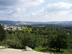
- Eshtaol ForestEshtaol ForestEshtaol Forest is a forest in Israel, located north of Beit Shemesh and near Ta'oz and Neve Shalom. The Forest of the Martyrs lies to the east. The forest is a popular recreation area and is one of the largest forests in Israel...
- near Beit Shemesh - Gilo Forest – (GiloGiloGilo is a neighborhood in southern East Jerusalem with a population of 40,000, mostly Jewish. It is one of the five ring neighborhoods of Jerusalem and is built on land in the West Bank that was annexed to Israel in 1980 under the Jerusalem Law. The international community regards it as an...
neighborhood) - Jerusalem ForestJerusalem ForestThe Jerusalem Forest is a pine forest located in the Judean Mountains west of Jerusalem. It is surrounded by the Jerusalem neighborhoods Beit HaKerem, Yefe Nof, Ein Kerem, Har Nof, Givat Shaul, and a moshav, Beit Zeit. The forest was planted during the 1950s by the Jewish National Fund, financed by...
– (between Givat ShaulGivat ShaulGivat Shaul is a neighborhood in western Jerusalem named after the Rishon Lezion, Rabbi Yaakov Shaul Elyashar, the Sephardi Chief Rabbi of Israel, and not, as commonly believed, for the biblical King Saul, whose capital was probably located on the hill Gibeah of Saul near Pisgat Ze'ev, on the way...
neighborhood and Ein Karem) - Martyrs Forest – (above MoshavMoshavMoshav is a type of Israeli town or settlement, in particular a type of cooperative agricultural community of individual farms pioneered by the Labour Zionists during the second aliyah...
KsalonKsalonKsalon is a moshav in central Israel. Located near Beit Shemesh, it falls under the jurisdiction of Mateh Yehuda Regional Council. In 2006 it had a population of 314....
(Shimshon-Sha'ar HaGai Junction) - Peace ForestPeace ForestPeace forest is a forest in South - Southeast Jerusalem, Israel, between the Abu Tor neighbourhood and the Sherover Promenade. It was a location of the biblical Etsel river mentioned in the book of Zechariah .There is a number of graves of the Second Temple era found in the Peace Forest, some of...
– (below East TalpiotTalpiotTalpiot , is a neighborhood in southeast Jerusalem, Israel, established in 1922 by Zionist pioneers.-Etymology:The name Talpiot derives from a verse in Song of Songs 4:4 – "Thy neck is like the tower of David, built with turrets." According to rabbinic sources, Talpiot refers to the Temple...
promenade) - Ramot Forest – (between RamotRamotRamot , also known as Ramot Alon , is a large housing development in northwestern Jerusalem. Because part of Ramot lies north of the Green Line in East Jerusalem, the international community considers Ramot an Israeli settlement that is illegal under international law. Israel disputes this and...
neighborhood and Shu'afat) - Aminadav ForestAminadavAminadav is a moshav in central Israel. Located southwest of Jerusalem near Yad Kennedy, it falls under the jurisdiction of Mateh Yehuda Regional Council...
- Judean hills near AminadavAminadavAminadav is a moshav in central Israel. Located southwest of Jerusalem near Yad Kennedy, it falls under the jurisdiction of Mateh Yehuda Regional Council... - Canada Forest - Jerusalem corridorJerusalem corridorThe Jerusalem corridor is a segment of Israeli territory between the Shephelah and Jerusalem which is home to over 700,000 Israeli Jews. Not including the Arab population of annexed East Jerusalem the areas population is almost 99% Jewish. Roughly stretching from Latrun in the west to Jerusalem in...
Center DistrictCenter District (Israel)The Central District of Israel is one of six administrative districts, including most of the Sharon region. The district capital is Ramla. It is further divided into 4 sub-districts: Petah Tikva, Ramla, Sharon and Rehovot. The district's largest city is Rishon LeZion. Its population as of 2008 was...
- Ben Shemen Forest – (east of Ben ShemenBen ShemenBen Shemen is a moshav in central Israel. Located around four kilometres east of Lod, it falls under the jurisdiction of Hevel Modi'in Regional Council. In 2006 it had a population of 627....
youth villageYouth villageA youth village is a boarding school model first developed in Mandate Palestine in the 1930s to care for groups of children and teenagers fleeing the Nazis...
) - Hulda Forest – (NahshonNahshonNahshon or Naḥshon ben ʿAmminadabh was, according to the Book of Exodus, the son of Amminadab; descendant in the fifth generation of Judah, brother-in-law of Aaron and an important figure in the Hebrew's Passage of the Red Sea which according to the Jewish Midrash he initiated by walking in head...
Junction – RehovotRehovotRehovot is a city in the Center District of Israel, about south of Tel Aviv. According to the Israel Central Bureau of Statistics , at the end of 2009 the city had a total population of 112,700. Rehovot's official website estimates the population at 114,000.Rehovot was built on the site of Doron,...
road) - Tzora Forest – (between Shimshon and NahshonNahshon, IsraelNahshon is a kibbutz in central Israel. Located to the north of Beit Shemesh, it falls under the jurisdiction of Mateh Yehuda Regional Council. In 2007 it had a population of 412....
Junctions) near TzoraTzoraTzora is a kibbutz in central Israel. Located about 20 km from Jerusalem, near the city of Beit Shemesh, it falls under the jurisdiction of Mateh Yehuda Regional Council. At the beginning of 2009, the kibbutz had a total population of 800, of whom 350 were members.-History:The kibbutz derives its... - Meginim Forest - GezerGezerGezer was a Canaanite city-state and biblical town in ancient Israel. Tel Gezer , an archaeological site midway between Jerusalem and Tel Aviv, is now an Israeli national park....
region
Northern District
- Irron Forest – (HaderaHaderaHadera is a city located in the Haifa District of Israel approximately from the major cities of Tel Aviv and Haifa. The city is located along of the Israeli Mediterranean Coastal Plain...
-Megiddo Road) - Carmel Coast Forest – (FureidisFureidisFureidis is an Israeli Arab town in the Haifa District of Israel. It received local council status in 1952.-History:Fureidis was established in the 19th century. The name is believed to come from the Arabic , meaning little Garden of Eden, borrowed from the Persian paradise...
-HaifaHaifaHaifa is the largest city in northern Israel, and the third-largest city in the country, with a population of over 268,000. Another 300,000 people live in towns directly adjacent to the city including the cities of the Krayot, as well as, Tirat Carmel, Daliyat al-Karmel and Nesher...
Road) - Hadera Forest – (near railway station)
- Mt. Hurshan – (near AmikamAmikamAmikam is a moshav in northern Israel. Located near Zikhron Ya'akov, it falls under the jurisdiction of Alona Regional Council, whose headquarters are located in the moshav. In 2006 it had a population of 561...
) - Mt. Shehumit (Har Nahash) - (Kiryat ShmonaKiryat ShmonaKiryat Shmona is a city located in the North District of Israel on the western slopes of the Hula Valley on the Lebanese border. The city was named for the eight people, including Joseph Trumpeldor, who died in 1920 defending Tel Hai....
)
GalileeGalileeGalilee , is a large region in northern Israel which overlaps with much of the administrative North District of the country. Traditionally divided into Upper Galilee , Lower Galilee , and Western Galilee , extending from Dan to the north, at the base of Mount Hermon, along Mount Lebanon to the...
- Biriya Forest – (SafedSafedSafed , is a city in the Northern District of Israel. Located at an elevation of , Safed is the highest city in the Galilee and of Israel. Due to its high elevation, Safed experiences warm summers and cold, often snowy, winters...
-Biriya Road) - Parod Forest – (AcreAcre, IsraelAcre , is a city in the Western Galilee region of northern Israel at the northern extremity of Haifa Bay. Acre is one of the oldest continuously inhabited sites in the country....
-SafedSafedSafed , is a city in the Northern District of Israel. Located at an elevation of , Safed is the highest city in the Galilee and of Israel. Due to its high elevation, Safed experiences warm summers and cold, often snowy, winters...
Road, near Kibbutz Parod) - Ahihud Forest – (AcreAcre, IsraelAcre , is a city in the Western Galilee region of northern Israel at the northern extremity of Haifa Bay. Acre is one of the oldest continuously inhabited sites in the country....
-SafedSafedSafed , is a city in the Northern District of Israel. Located at an elevation of , Safed is the highest city in the Galilee and of Israel. Due to its high elevation, Safed experiences warm summers and cold, often snowy, winters...
Road near Mt. Gamal) - Lower Hanita Forest – (Shlomi-HanitaHanitaHanita is a kibbutz in northern Israel. Located in the western Galilee approximately 15 kilometres northeast of Nahariya, it falls under the jurisdiction of Mateh Asher Regional Council. In 2011 it had a population of 500....
Road)
Upper GalileeUpper GalileeThe Upper Galilee is a geographical-political term in use since the end of the Second Temple period, originally referring to a mountainous area overlapping the present northern Israel and southern Lebanon, its borders being the Litani river in the north, the Mediterranean Sea in the west, the Beit...
- Baram Forest – (Shlomi-SasaSasaSasa may refer to: menina linda com pernas jeitosas ;)* Samoan Sasa* Saša, a given name* Sasa - a genus of bamboo* Sasa, Israel - a kibbutz in Galilee, Israel* Sa'sa' - a Palestinian village, depopulated during the 1948 Arab-Israeli war....
Road, near Meron Junction) - Mt. Turan – (near Golani JunctionGolani JunctionGolani Junction , known as Maskana Junction in Arabic, is a key road junction in the Lower Galilee region of northern Israel, located east of Haifa and west of Tiberias, at the intersection of highways 65 and 77. The Golani Brigade Museum commemorating the Golani Brigade is situated there...
-Mitzpe NetofaMitzpe NetofaMitzpe Netofa is a religious communal settlement in the Lower Galilee Regional Council, Israel. The village is adjacent to the Arab village Tur'an.The village was founded in 1981. The village comprised, as of 2008, about 200 families....
) - Lavi Forest – (Golani JunctionGolani JunctionGolani Junction , known as Maskana Junction in Arabic, is a key road junction in the Lower Galilee region of northern Israel, located east of Haifa and west of Tiberias, at the intersection of highways 65 and 77. The Golani Brigade Museum commemorating the Golani Brigade is situated there...
)
South DistrictSouth District (Israel)The Southern District is one of Israel's six administrative districts, and is the largest in terms of land area as well as the most sparsely populated. It covers most of the Negev desert, as well as the Arabah valley. The population of the Southern District is 1,002,400. It is 86% Jewish and 14%...
- Melachim Forest, Shachariya – (between Kiryat Gat and Lakhish Junction)
- Amatzia woodlands – (near Amatzia)
NegevNegevThe Negev is a desert and semidesert region of southern Israel. The Arabs, including the native Bedouin population of the region, refer to the desert as al-Naqab. The origin of the word Neghebh is from the Hebrew root denoting 'dry'...
- Yatir ForestYatir ForestYatir Forest is a forest in Israel, located on the southern slopes of Mount Hebron, on the edge of the Negev Desert. The forest covers an area of 30,000 dunams , and is the largest planted forest in Israel.-History:...
– (northeast NegevNegevThe Negev is a desert and semidesert region of southern Israel. The Arabs, including the native Bedouin population of the region, refer to the desert as al-Naqab. The origin of the word Neghebh is from the Hebrew root denoting 'dry'...
) - Lahav Forest – (northern NegevNegevThe Negev is a desert and semidesert region of southern Israel. The Arabs, including the native Bedouin population of the region, refer to the desert as al-Naqab. The origin of the word Neghebh is from the Hebrew root denoting 'dry'...
) - Be'eri Forest – (on Road No. 232 near Be'eriBe'eriBe'eri is a kibbutz in southern Israel. Located in the north-western Negev desert near the border with the Gaza Strip, it falls under the jurisdiction of Eshkol Regional Council. In 2006 it had a population of 774.-History:...
from Hodiya Junction (Road No. 232) off ZikimZikimZikim is a kibbutz in the southern Israel. Located in the northern Negev desert, it falls under the jurisdiction of Hof Ashkelon Regional Council. In 2006, it had a population of 385....
-KarmiaKarmiaKarmia is a kibbutz in southern Israel. Located between Ashkelon and the Gaza Strip, it falls under the jurisdiction of Hof Ashkelon Regional Council. In 2006 it had a population of 464....
Road)
See also
- Jewish National FundJewish National FundThe Jewish National Fund was founded in 1901 to buy and develop land in Ottoman Palestine for Jewish settlement. The JNF is a quasi-governmental, non-profit organisation...
- List of national parks and nature reserves of Israel