
List of bridges on the National Register of Historic Places in Utah
Encyclopedia
This is a list of bridge
s and tunnel
s on the National Register of Historic Places
in the U.S. state
of Utah
.
Bridge
A bridge is a structure built to span physical obstacles such as a body of water, valley, or road, for the purpose of providing passage over the obstacle...
s and tunnel
Tunnel
A tunnel is an underground passageway, completely enclosed except for openings for egress, commonly at each end.A tunnel may be for foot or vehicular road traffic, for rail traffic, or for a canal. Some tunnels are aqueducts to supply water for consumption or for hydroelectric stations or are sewers...
s on the National Register of Historic Places
National Register of Historic Places
The National Register of Historic Places is the United States government's official list of districts, sites, buildings, structures, and objects deemed worthy of preservation...
in the U.S. state
U.S. state
A U.S. state is any one of the 50 federated states of the United States of America that share sovereignty with the federal government. Because of this shared sovereignty, an American is a citizen both of the federal entity and of his or her state of domicile. Four states use the official title of...
of Utah
Utah
Utah is a state in the Western United States. It was the 45th state to join the Union, on January 4, 1896. Approximately 80% of Utah's 2,763,885 people live along the Wasatch Front, centering on Salt Lake City. This leaves vast expanses of the state nearly uninhabited, making the population the...
.
| Name | Image | Built | Listed | Location | County | Type |
|---|---|---|---|---|---|---|
| Cable Creek Bridge | 1932 | 1996-02-16 | Floor of the Valley Road Floor of the Valley Road The Floor of the Valley Road, also known as the Zion Canyon Scenic Drive, follows the canyon of the North Fork of the Virgin River, also known as Zion Canyon, through Zion National Park, Utah... , Zion National Park Zion National Park Zion National Park is located in the Southwestern United States, near Springdale, Utah. A prominent feature of the park is Zion Canyon, which is 15 miles long and up to half a mile deep, cut through the reddish and tan-colored Navajo Sandstone by the North Fork of the Virgin River... 37°16′13"N 112°56′19"W |
Washington Washington County, Utah As of the census of 2000, there were 90,354 people, 29,939 households, and 23,442 families residing in the county. The population density was 37 people per square mile . There were 36,478 housing units at an average density of 15 per square mile... |
NPS Rustic | |
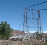
| Dewey Bridge | 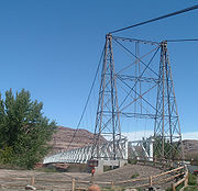 |
1916 destroyed 2008 |
1984-07-12 | old SR-128 over Colorado River Colorado River The Colorado River , is a river in the Southwestern United States and northwestern Mexico, approximately long, draining a part of the arid regions on the western slope of the Rocky Mountains. The watershed of the Colorado River covers in parts of seven U.S. states and two Mexican states... , Dewey Dewey, Utah Dewey is a ghost town in Grand County, Utah. Originally named Kingsferry, it began in the 1880s when Samuel King built and operated a ferry across the Grand River . A small community soon developed around the ferry, although it never grew large. The town served as a ferry crossing until the Dewey... 38°48′43"N 109°18′9"W |
Grand Grand County, Utah Grand County is a county located in the U.S. state of Utah. As of 2000 the population was 8,485, and by 2005 had been estimated at 8,743. It was named for the Colorado River, which at the time of statehood was known as the Grand River. Its county seat and largest city is Moab.-Geography:According... |
|
| Hurricane-LaVerkin Bridge | 1908 | 1995-04-14 | old SR-9 over Virgin River Virgin River The Virgin River is a tributary of the Colorado River in the U.S. states of Utah, Nevada, and Arizona. The river is about long. It was designated Utah's first wild and scenic river in 2009, during the centennial celebration of Zion National Park.-Course:... , between Hurricane Hurricane, Utah Hurricane is a city in Washington County, Utah. Its population was 13,748 at the 2010 U.S. Census. Along with several other areas of southwestern Utah, the Hurricane area has seen a large population growth since the 1970s, and it has blended in with neighboring city of St... and La Verkin La Verkin, Utah La Verkin is a city in Washington County, Utah, United States. The population was 4,719 as of 2010, an increase from 3,392 in 2000. La Verkin is within walking distance of Hurricane, Utah, and the two cities have historically had close ties.... 37°11′22"N 113°16′13"W |
Washington Washington County, Utah As of the census of 2000, there were 90,354 people, 29,939 households, and 23,442 families residing in the county. The population density was 37 people per square mile . There were 36,478 housing units at an average density of 15 per square mile... |
||
| Lincoln Highway Bridge | 1900 | 1975-05-21 | old Lincoln Highway Lincoln Highway The Lincoln Highway was the first road across the United States of America.Conceived and promoted by entrepreneur Carl G. Fisher, the Lincoln Highway spanned coast-to-coast from Times Square in New York City to Lincoln Park in San Francisco, originally through 13 states: New York, New Jersey,... over Government Creek, Dugway Proving Ground 40°10′58"N 112°55′23"W |
Tooele Tooele County, Utah Tooele County is a county located in the U.S. state of Utah. As of 2000, the population was 40,735 and by 2005 was estimated at 51,311. Its county seat and largest city is Tooele.... |
||
| Murphy Trail and Bridge Murphy Trail and Bridge The Murphy Trail and Bridge were used to move livestock from winter range along the Green River to highland summer range from about 1917 to about 1964. The trail and bridge are located in what is now Canyonlands National Park in Utah, and the trail is now used as a hiking path. The bridge was made... |
1917 | 1988-10-07 | Sidehill viaduct on Murphy Trail descending from the Island in the Sky district, Canyonlands National Park Canyonlands National Park Canyonlands National Park is a U.S. National Park located in southeastern Utah near the town of Moab and preserves a colorful landscape eroded into countless canyons, mesas and buttes by the Colorado River, the Green River, and their respective tributaries. The park is divided into four districts:... 38°20′30"N 109°52′30"W |
San Juan San Juan County, Utah As of the current census of 2010, there were 14,746 people and 4,505 households. The racial and ethnic composition of the population was 50.4% Native American, 45.8% white, 0.3% Asian, 0.2% African American and 2.3% reporting two or more races... |
||
| Rockville Bridge | 1924 | 1995-08-04 | Bridge Road over Virgin River Virgin River The Virgin River is a tributary of the Colorado River in the U.S. states of Utah, Nevada, and Arizona. The river is about long. It was designated Utah's first wild and scenic river in 2009, during the centennial celebration of Zion National Park.-Course:... , Rockville Rockville, Utah Rockville is a town in Washington County, Utah, United States. It is located along the Virgin River near the mouth of Zion Canyon. The city lies just outside of the park boundary for Zion National Park; the park entrance is located approximately 5 miles northeast of the town.-Geography:Rockville... 37°9′30"N 113°2′16"W |
Washington Washington County, Utah As of the census of 2000, there were 90,354 people, 29,939 households, and 23,442 families residing in the county. The population density was 37 people per square mile . There were 36,478 housing units at an average density of 15 per square mile... |
||
| San Rafael Bridge | 1935, 1937 | 1996-06-03 | Buckhorn Draw Road over San Rafael River, southeast of Castle Dale Castle Dale, Utah Castle Dale is a city in Emery County, Utah, United States. The population was 1,657 at the 2000 census. It is the county seat of Emery County.-History:... 39°4′52"N 110°39′49"W |
Emery Emery County, Utah Emery County is a county located in the U.S. state of Utah. As of 2000 the population was 10,860, and by 2009 had been estimated to decrease to 10,629. It was named for George W. Emery, governor of the Utah Territory in 1875... |
||
| Southern Pacific Railroad: Ogden-Lucin Cut-Off Trestle | 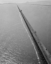 |
1902–1904 | 1972-04-14 | Lucin Cutoff Lucin Cutoff The Lucin Cutoff is a railroad line which included a railroad trestle which crossed the Great Salt Lake in Utah. Built by the Southern Pacific Company between February 1902 and March 1904 across Promontory Point, it bypassed the original Central Pacific Railroad route through Promontory Summit... over Great Salt Lake Great Salt Lake The Great Salt Lake, located in the northern part of the U.S. state of Utah, is the largest salt water lake in the western hemisphere, the fourth-largest terminal lake in the world. In an average year the lake covers an area of around , but the lake's size fluctuates substantially due to its... , west of Ogden Ogden, Utah Ogden is a city in Weber County, Utah, United States. Ogden serves as the county seat of Weber County. The population was 82,825 according to the 2010 Census. The city served as a major railway hub through much of its history, and still handles a great deal of freight rail traffic which makes it a... 41°12′N 112°30′W |
Box Elder Box Elder County, Utah Box Elder County is a county located in the U.S. state of Utah. It lies on the north end of the Great Salt Lake, covering a large area north to the Idaho border and west to the Nevada border. Included in this area are large tracts of barren desert, contrasted by high, forested mountains. The... |
|
| Zion-Mount Carmel Highway | 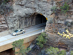 |
1930 | 1987-07-07 | SR-9 through Zion National Park Zion National Park Zion National Park is located in the Southwestern United States, near Springdale, Utah. A prominent feature of the park is Zion Canyon, which is 15 miles long and up to half a mile deep, cut through the reddish and tan-colored Navajo Sandstone by the North Fork of the Virgin River... bridges over North Fork Virgin River, Pine Creek (twice), Co-op Creek two tunnels, including the Zion-Mount Carmel Tunnel 37°13′N 112°56′W |
Washington Washington County, Utah As of the census of 2000, there were 90,354 people, 29,939 households, and 23,442 families residing in the county. The population density was 37 people per square mile . There were 36,478 housing units at an average density of 15 per square mile... |