
List of bridges on the National Register of Historic Places in Massachusetts
Encyclopedia
This is a list of bridge
s and tunnel
s on the National Register of Historic Places
in the U.S. state
of Massachusetts
.
Bridge
A bridge is a structure built to span physical obstacles such as a body of water, valley, or road, for the purpose of providing passage over the obstacle...
s and tunnel
Tunnel
A tunnel is an underground passageway, completely enclosed except for openings for egress, commonly at each end.A tunnel may be for foot or vehicular road traffic, for rail traffic, or for a canal. Some tunnels are aqueducts to supply water for consumption or for hydroelectric stations or are sewers...
s on the National Register of Historic Places
National Register of Historic Places
The National Register of Historic Places is the United States government's official list of districts, sites, buildings, structures, and objects deemed worthy of preservation...
in the U.S. state
U.S. state
A U.S. state is any one of the 50 federated states of the United States of America that share sovereignty with the federal government. Because of this shared sovereignty, an American is a citizen both of the federal entity and of his or her state of domicile. Four states use the official title of...
of Massachusetts
Massachusetts
The Commonwealth of Massachusetts is a state in the New England region of the northeastern United States of America. It is bordered by Rhode Island and Connecticut to the south, New York to the west, and Vermont and New Hampshire to the north; at its east lies the Atlantic Ocean. As of the 2010...
.
| Name | Image | Built | Listed | Location | County | Type |
|---|---|---|---|---|---|---|
| Annisquam Bridge Annisquam Bridge Annisquam Bridge is a historic bridge in Annisquam, Massachusetts, a village within the city of Gloucester.Built in 1861 to cross Lobster Cove, the bridge was added to the National Historic Register of Historic Places in 1983. It is a wood pile bridge.... |
1861, 1896, 1961 | 1983-06-23 | Gloucester Gloucester, Massachusetts Gloucester is a city on Cape Ann in Essex County, Massachusetts, in the United States. It is part of Massachusetts' North Shore. The population was 28,789 at the 2010 U.S. Census... |
Essex Essex County, Massachusetts -National protected areas:* Parker River National Wildlife Refuge* Salem Maritime National Historic Site* Saugus Iron Works National Historic Site* Thacher Island National Wildlife Refuge-Demographics:... |
Wood pile type | |
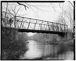
| Atherton Bridge Atherton Bridge Atherton Bridge is a historic iron truss bridge on Bolton Road in Lancaster, Massachusetts, spanning the South Branch of the Nashua River. It is a rare example of a hybrid pony truss that is similar to the 19th century truss design of Simeon S. Post. It was built by J.H. Cofrode & Co. of... |
 |
1870 | 1979-09-19 | Lancaster Lancaster, Massachusetts Lancaster is a town in Worcester County, Massachusetts, in the United States. Incorporated in 1653, Lancaster is the oldest town in Worcester County... 42°26′40"N 71°40′21"W |
Worcester Worcester County, Massachusetts -Demographics:In 1990 Worcester County had a population of 709,705.As of the census of 2000, there were 750,963 people, 283,927 households, and 192,502 families residing in the county. The population density was 496 people per square mile . There were 298,159 housing units at an average density... |
single span Pony/Post Truss |
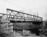
| Bardwell's Ferry Bridge Bardwell's Ferry Bridge The Bardwell's Ferry Bridge, built in 1882, is an historic lenticular Truss bridge spanning the Deerfield River between the towns of Shelburne and Conway in Franklin County, Massachusetts. The bridge is listed on the National Register of Historic Places.... |
 |
1882 | 2000-02-10 | Conway Conway, Massachusetts Conway is a town in Franklin County, Massachusetts, United States. The population was 1,809 at the 2000 census. It is part of the Springfield, Massachusetts Metropolitan Statistical Area.- History :... 42°33′20"N 72°40′41"W |
Franklin Franklin County, Massachusetts -Demographics:As of the census of 2000, there were 71,535 people, 29,466 households, and 18,416 families residing in the county. The population density was 102 people per square mile . There were 31,939 housing units at an average density of 46 per square mile... |
|
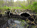
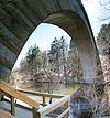
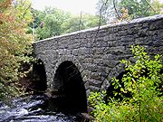
| Bartlett's Bridge Bartlett's Bridge Bartlett's Bridge is a historic, stone arch bridge on Clara Barton Road over the French River in Oxford, Massachusetts.The bridge was built in 1889 with much of design done by Charles A. Allen. It was added to the National Register of Historic Places in 2000.... |
1889 | 2000-02-10 | Oxford Oxford, Massachusetts Oxford is a town in Worcester County, Massachusetts, United States. The population was 13,709 at the 2010 census.For geographic and demographic information on the census-designated place Oxford, please see the article Oxford , Massachusetts.-History:... 42°9′17"N 71°52′59"W |
Worcester Worcester County, Massachusetts -Demographics:In 1990 Worcester County had a population of 709,705.As of the census of 2000, there were 750,963 people, 283,927 households, and 192,502 families residing in the county. The population density was 496 people per square mile . There were 298,159 housing units at an average density... |
||
| Bissell Bridge Bissell Bridge (Massachusetts) Bissell Bridge is a historic bridge on Heath Road, MA 8A over Mill Brook in Charlemont, Massachusetts.The bridge was added to the National Historic Register in 2004.... |
2004-02-26 | Charlemont Charlemont, Massachusetts Charlemont is a town in Franklin County, Massachusetts, United States. The population was 1,358 at the 2000 census. It is part of the Springfield, Massachusetts Metropolitan Statistical Area.- History :... 42°37′57"N 72°52′10"W |
Franklin Franklin County, Massachusetts -Demographics:As of the census of 2000, there were 71,535 people, 29,466 households, and 18,416 families residing in the county. The population density was 102 people per square mile . There were 31,939 housing units at an average density of 46 per square mile... |
Long Through Truss | ||
| Blackstone Viaduct Blackstone Viaduct Blackstone Viaduct or "New York & New England Railroad Viaduct" is a historic viaduct on Canal, Farnum and Mill Streets in Blackstone, Massachusetts.... |
1872, 1918 | 2002-02-05 | Blackstone Blackstone, Massachusetts Blackstone is a town in Worcester County, Massachusetts, United States. The population was 9,026 at the 2010 census. It is formally a part of the Providence metropolitan area. Blackstone is the only municipality in Massachusetts to employ automatic cameras in traffic enforcement.- History :This... 42°0′55"N 71°32′0"W |
Worcester Worcester County, Massachusetts -Demographics:In 1990 Worcester County had a population of 709,705.As of the census of 2000, there were 750,963 people, 283,927 households, and 192,502 families residing in the county. The population density was 496 people per square mile . There were 298,159 housing units at an average density... |
||
| Burkeville Covered Bridge Burkeville Covered Bridge Burkeville Covered Bridge is a historic bridge on Main Poland Road over South River in Conway, Massachusetts.The bridge was built in 1870 and added to the National Historic Register in 1988.... |
1870, 1871 | 1988-09-09 | Conway Conway, Massachusetts Conway is a town in Franklin County, Massachusetts, United States. The population was 1,809 at the 2000 census. It is part of the Springfield, Massachusetts Metropolitan Statistical Area.- History :... 42°29′1"N 72°42′44"W |
Franklin Franklin County, Massachusetts -Demographics:As of the census of 2000, there were 71,535 people, 29,466 households, and 18,416 families residing in the county. The population density was 102 people per square mile . There were 31,939 housing units at an average density of 46 per square mile... |
Multiple kingrod truss | |
| Canton Viaduct Canton Viaduct Canton Viaduct is the oldest blind arcade cavity wall bridge in the world and it was the longest and tallest railroad bridge ever built when it was completed in 1835. It is the last surviving bridge of its kind and has been in continuous service for years; it now carries high-speed passenger and... |
1834 | 1984-09-20 | Canton Canton, Massachusetts Canton is a town in Norfolk County, Massachusetts, United States. The population was 21,561 at the 2010 census. Canton is part of Greater Boston, about 15 miles southwest of downtown Boston.- History :... 42°9′28"N 71°9′17"W |
Norfolk Norfolk County, Massachusetts -National protected areas:* Adams National Historical Park* Boston Harbor Islands National Recreation Area * Frederick Law Olmsted National Historic Site* John Fitzgerald Kennedy National Historic Site-Demographics:... |
||
| Carpenter Bridge Carpenter Bridge (Massachusetts) Carpenter Bridge is a historic bridge on Carpenter Street in Rehoboth, Massachusetts.The bridge was built in 1873 and added to the National Historic Register in 1983.... |
1873 | 1983-06-06 | Rehoboth Rehoboth, Massachusetts Rehoboth is a town in Bristol County, Massachusetts, United States. The population was 10,172 at the 2000 census.-History:It was incorporated in 1643 making it one of the earliest Massachusetts towns to be incorporated. The Rehoboth Carpenter Family is among the founding families... 41°49′41"N 71°15′20"W |
Bristol Bristol County, Massachusetts -Demographics:As of the census of 2000, there were 534,678 people, 205,411 households, and 140,706 families residing in the county. The population density was 962 people per square mile . There were 216,918 housing units at an average density of 390 per square mile... |
||
| Choate Bridge Choate Bridge Choate Bridge is a historic stone arch bridge on Route 1A/Route 133 over the Ipswich River in Ipswich, Massachusetts that is the oldest surviving double arch bridge in North America.-History:... |
 |
1764 | 1972-08-21 | Ipswich Ipswich, Massachusetts Ipswich is a coastal town in Essex County, Massachusetts, United States. The population was 12,987 at the 2000 census. Home to Willowdale State Forest and Sandy Point State Reservation, Ipswich includes the southern part of Plum Island... 42°40′46"N 70°50′16"W |
Essex Essex County, Massachusetts -National protected areas:* Parker River National Wildlife Refuge* Salem Maritime National Historic Site* Saugus Iron Works National Historic Site* Thacher Island National Wildlife Refuge-Demographics:... |
Double stone arch (oldest bridge in the country of its type) |
| Coleman Bridge Coleman Bridge (Windsor, Massachusetts) Coleman Bridge is a historic Ball-patent pipe bridge on Windsor Bush Road over Phelps Brook in Windsor, Massachusetts.The bridge was built in 1894 and added to the National Historic Register in 2000. It is a Ball-patent pipe bridge.... |
2000-02-18 | Windsor Windsor, Massachusetts Windsor is a town in Berkshire County, Massachusetts, United States. It is part of the Pittsfield, Massachusetts Metropolitan Statistical Area. The population was 875 at the 2000 census.-History:... 42°31′56"N 72°59′36"W |
Berkshire Berkshire County, Massachusetts Berkshire County is a non-governmental county located on the western edge of the U.S. state of Massachusetts. As of the 2010 census, the population was 131,219. Its largest city and traditional county seat is Pittsfield... |
Ball-patent Pipe Bridge | ||
| Crossman Bridge | 2010-12-27 | Warren Warren, Massachusetts Warren is a town in Worcester County, Massachusetts, United States. The population was 5,135 at the 2010 census.For geographic and demographic information on the census-designated place Warren, please see the article Warren , Massachusetts.- History :... |
Worcester Worcester County, Massachusetts -Demographics:In 1990 Worcester County had a population of 709,705.As of the census of 2000, there were 750,963 people, 283,927 households, and 192,502 families residing in the county. The population density was 496 people per square mile . There were 298,159 housing units at an average density... |
|||
| Double-arch Sandstone Bridge Double-arch Sandstone Bridge Double-arch Sandstone Bridge or more commonly known as the Sands Bridge, is a historic dry stone arch bridge over the Spicket River on Hampshire Road in Methuen, Massachusetts. Built without mortar between the stones, parts of it date back to 1735... |
 |
1835 | 1984-06-20 | Methuen Methuen, Massachusetts Methuen is a city in Essex County, Massachusetts, United States. The population was 43,789 at the 2000 census.-History:Methuen was first settled in 1642 and was officially incorporated in 1726; it is named for the British diplomat Sir Paul Methuen. Methuen was originally part of Haverhill,... 42°44′33"N 71°12′29"W |
Essex Essex County, Massachusetts -National protected areas:* Parker River National Wildlife Refuge* Salem Maritime National Historic Site* Saugus Iron Works National Historic Site* Thacher Island National Wildlife Refuge-Demographics:... |
Mortarless twin arch |
| Echo Bridge Echo Bridge Echo Bridge was built to carry the Sudbury Aqueduct over the Charles River from Newton Upper Falls to Needham, Massachusetts. The aqueduct was constructed to carry water from the Sudbury River to Boston. Construction of Echo Bridge began in 1875 and was completed in 1877 by Boston Water Works ,... |
 |
1876, 1877 | 1980-04-09 | Needham Needham, Massachusetts Needham is a town in Norfolk County, Massachusetts, United States. A suburb of Boston, its population was 28,886 at the 2010 census.- History :... , Newton Newton, Massachusetts Newton is a city in Middlesex County, Massachusetts, United States bordered to the east by Boston. According to the 2010 U.S. Census, the population of Newton was 85,146, making it the eleventh largest city in the state.-Villages:... 42°18′53"N 71°13′39"W |
Middlesex Middlesex County, Massachusetts -National protected areas:* Assabet River National Wildlife Refuge* Great Meadows National Wildlife Refuge* Longfellow National Historic Site* Lowell National Historical Park* Minute Man National Historical Park* Oxbow National Wildlife Refuge... , Norfolk Norfolk County, Massachusetts -National protected areas:* Adams National Historical Park* Boston Harbor Islands National Recreation Area * Frederick Law Olmsted National Historic Site* John Fitzgerald Kennedy National Historic Site-Demographics:... |
|
| Eliot Memorial Bridge Eliot Memorial Bridge The Eliot Memorial Bridge is a footbridge which was built in 1904 in memory of Charles Eliot, landscape architect to the Metropolitan Park Commission... |
1905 | 1980-09-25 | Milton Milton, Massachusetts Milton is a town in Norfolk County, Massachusetts, United States and part of the Greater Boston area. The population was 27,003 at the 2010 census. Milton is the birthplace of former U.S. President George H. W. Bush and architect Buckminster Fuller. Milton also has the highest percentage of... 42°12′42"N 71°6′49"W |
Norfolk Norfolk County, Massachusetts -National protected areas:* Adams National Historical Park* Boston Harbor Islands National Recreation Area * Frederick Law Olmsted National Historic Site* John Fitzgerald Kennedy National Historic Site-Demographics:... |
||
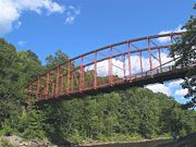
| Golden Hill Bridge Golden Hill Bridge Golden Hill Bridge is a historic bridge on Golden Hill Road over the Housatonic River in Lee, Massachusetts.... |
1994-02-09 | Lee Lee, Massachusetts Lee is a town in Berkshire County, Massachusetts, United States. It is part of the Pittsfield, Massachusetts, metropolitan statistical area. The population was 5,943 which was determined in the 2010 census. Lee, which includes the villages of South and East Lee, is part of the Berkshires resort... 42°19′18"N 73°14′33"W |
Berkshire Berkshire County, Massachusetts Berkshire County is a non-governmental county located on the western edge of the U.S. state of Massachusetts. As of the 2010 census, the population was 131,219. Its largest city and traditional county seat is Pittsfield... |
|||
| Granite Keystone Bridge Granite Keystone Bridge Granite Keystone Bridge is a historic bridge on Granite Street in Rockport, Massachusetts.It was built in 1872 and added to the National Register of Historic Places in 1981.... |
1872 | 1981-08-27 | Rockport Rockport, Massachusetts Rockport is a town in Essex County, Massachusetts, United States. The population was 6,952 at the 2010 census. Rockport is located approximately 25 miles northeast of Boston at the tip of the Cape Ann peninsula... 42°40′1"N 70°37′33"W |
Essex Essex County, Massachusetts -National protected areas:* Parker River National Wildlife Refuge* Salem Maritime National Historic Site* Saugus Iron Works National Historic Site* Thacher Island National Wildlife Refuge-Demographics:... |
Pratt truss | |
| Harris Street Bridge Harris Street Bridge Harris Street Bridge is an historic bridge that spans the Taunton River at Dean and Harris Streets in Taunton, Massachusetts.The bridge was built in 1887 and added to the National Historic Register in 1984.-See also:... |
 |
1887 | 1984-07-05 | Taunton Taunton, Massachusetts Taunton is a city in Bristol County, Massachusetts, United States. It is the seat of Bristol County and the hub of the Greater Taunton Area. The city is located south of Boston, east of Providence, north of Fall River and west of Plymouth. The City of Taunton is situated on the Taunton River... 41°54′20"N 71°4′12"W |
Bristol Bristol County, Massachusetts -Demographics:As of the census of 2000, there were 534,678 people, 205,411 households, and 140,706 families residing in the county. The population density was 962 people per square mile . There were 216,918 housing units at an average density of 390 per square mile... |
Pratt Truss |
| Hoosac Tunnel Hoosac Tunnel The Hoosac Tunnel is a 4.75-mile-long railroad tunnel in western Massachusetts which passes through the Hoosac Range, an extension of Vermont's Green Mountains. Work began in 1848 and was finally completed in 1875... |
 |
1854, 1862, 1875 | 1973-11-02 | North Adams North Adams, Massachusetts North Adams is a city in Berkshire County, Massachusetts, United States. It is part of the Pittsfield, Massachusetts Metropolitan Statistical Area. The population was 13,708 as of the 2010 census, making it the least populous city in the state... |
Berkshire Berkshire County, Massachusetts Berkshire County is a non-governmental county located on the western edge of the U.S. state of Massachusetts. As of the 2010 census, the population was 131,219. Its largest city and traditional county seat is Pittsfield... |
|
| Linden Street Bridge Linden Street Bridge Linden Street Bridge is a historic bridge on the Boston & Maine Railroad over Linden Street in Waltham, Massachusetts.It was built in 1894 by the Pennsylvania Steel Company and added to the National Register of Historic Places in 1989.... |
1894 | 1989-09-28 | Waltham Waltham, Massachusetts Waltham is a city in Middlesex County, Massachusetts, United States, was an early center for the labor movement, and major contributor to the American Industrial Revolution. The original home of the Boston Manufacturing Company, the city was a prototype for 19th century industrial city planning,... 42°22′48"N 71°13′15"W |
Middlesex Middlesex County, Massachusetts -National protected areas:* Assabet River National Wildlife Refuge* Great Meadows National Wildlife Refuge* Longfellow National Historic Site* Lowell National Historical Park* Minute Man National Historical Park* Oxbow National Wildlife Refuge... |
||
| Medford Pipe Bridge Medford Pipe Bridge The Medford Pipe Bridge is a historic bridge over the Mystic River, between S. Court St. and the Mystic Valley Parkway in Medford, Massachusetts.It was built in 1897 and added to the National Register of Historic Places in 1990.... |
1897, 1898 | 1990-01-18 | Medford Medford, Massachusetts Medford is a city in Middlesex County, Massachusetts, in the United States, on the Mystic River, five miles northwest of downtown Boston. In the 2010 U.S. Census, Medford's population was 56,173... 42°25′6"N 71°6′44"W |
Middlesex Middlesex County, Massachusetts -National protected areas:* Assabet River National Wildlife Refuge* Great Meadows National Wildlife Refuge* Longfellow National Historic Site* Lowell National Historical Park* Minute Man National Historical Park* Oxbow National Wildlife Refuge... |
||
| Middlefield-Becket Stone Arch Railroad Bridge District Middlefield-Becket Stone Arch Railroad Bridge District Middlefield-Becket Stone Arch Railroad Bridge District is a historic district extending through parts of the towns of Chester, Middlefield, and Becket, Massachusetts.The district was added to the National Register of Historic Places in 1980.... |
1840, ca. 1866, 1912 | 1980-04-11 | Becket Becket, Massachusetts Becket is a town in Berkshire County, Massachusetts, United States. It is part of the Pittsfield, Massachusetts Metropolitan Statistical Area. The population was 1,779 at the 2010 census.- History :... , Chester Chester, Massachusetts Chester is a town in Hampden County, Massachusetts, United States, situated in the western part of the state. It is part of the Springfield, Massachusetts metropolitan statistical area. The town includes the Chester Factory Village Historic District. The total population was 1,337 in the 2010... , Middlefield Middlefield, Massachusetts Middlefield is a town in Hampshire County, Massachusetts, United States. The population was 542 at the 2000 census. It is part of the Springfield, Massachusetts Metropolitan Statistical Area.-Geography:... |
Berkshire Berkshire County, Massachusetts Berkshire County is a non-governmental county located on the western edge of the U.S. state of Massachusetts. As of the 2010 census, the population was 131,219. Its largest city and traditional county seat is Pittsfield... , Hampden Hampden County, Massachusetts -Demographics:As of the census of 2004, there were 461,228 people, 175,288 households, and 115,690 families residing in the county. The population density was 738 people per square mile . There were 185,876 housing units at an average density of 301 per square mile... , Hampshire Hampshire County, Massachusetts -Demographics:As of the census of 2000, there were 152,251 people, 55,991 households, and 33,818 families residing in the county. The population density was 288 people per square mile . There were 58,644 housing units at an average density of 111 per square mile... |
||
| Needham Street Bridge Needham Street Bridge The Needham Street Bridge is a historic bridge at Needham Street over the Charles River connecting Needham and Newton, Massachusetts.It was built in 1875 and added to the National Register of Historic Places in 1986.... |
1875 | 1986-09-04 | Needham Needham, Massachusetts Needham is a town in Norfolk County, Massachusetts, United States. A suburb of Boston, its population was 28,886 at the 2010 census.- History :... , Newton Newton, Massachusetts Newton is a city in Middlesex County, Massachusetts, United States bordered to the east by Boston. According to the 2010 U.S. Census, the population of Newton was 85,146, making it the eleventh largest city in the state.-Villages:... 42°18′23"N 71°13′3"W |
Middlesex Middlesex County, Massachusetts -National protected areas:* Assabet River National Wildlife Refuge* Great Meadows National Wildlife Refuge* Longfellow National Historic Site* Lowell National Historical Park* Minute Man National Historical Park* Oxbow National Wildlife Refuge... , Norfolk Norfolk County, Massachusetts -National protected areas:* Adams National Historical Park* Boston Harbor Islands National Recreation Area * Frederick Law Olmsted National Historic Site* John Fitzgerald Kennedy National Historic Site-Demographics:... |
Stone-arch bridge | |
| Newton Street Bridge Newton Street Bridge Newton Street Bridge is a historic bridge on Newton Street at River Street over the Charles River in Waltham, Massachusetts.The bridge was built in 1877 by Hiram Balisdell and was added to the National Register of Historic Places in 1989.... |
1877 | 1989-09-28 | Waltham Waltham, Massachusetts Waltham is a city in Middlesex County, Massachusetts, United States, was an early center for the labor movement, and major contributor to the American Industrial Revolution. The original home of the Boston Manufacturing Company, the city was a prototype for 19th century industrial city planning,... 42°22′20"N 71°13′45"W |
Middlesex Middlesex County, Massachusetts -National protected areas:* Assabet River National Wildlife Refuge* Great Meadows National Wildlife Refuge* Longfellow National Historic Site* Lowell National Historical Park* Minute Man National Historical Park* Oxbow National Wildlife Refuge... |
Triple-arch stone bridge | |
| Old Covered Bridge Old Covered Bridge Old Covered Bridge is a historic covered bridge on Covered Bridge Lane in Sheffield, Massachusetts.The bridge was built in 1837 and added to the National Register of Historic Places in 1978.... |
1837, 1838 | 1978-11-24 | Sheffield Sheffield, Massachusetts Not to be confused with the city of Sheffield in the UK, or Sheffield, Vermont.Sheffield is a town in Berkshire County, Massachusetts, United States. It is part of the Pittsfield, Massachusetts Metropolitan Statistical Area. The population was 3,257 at the 2010 census. Sheffield is home to... 42°7′26"N 73°21′17"W |
Berkshire Berkshire County, Massachusetts Berkshire County is a non-governmental county located on the western edge of the U.S. state of Massachusetts. As of the 2010 census, the population was 131,219. Its largest city and traditional county seat is Pittsfield... |
Town Lattice Truss Bridge | |
| Old Town Bridge Old Town Bridge (Wayland, Massachusetts) Old Town Bridge, built in 1848, is a historic, stone arch bridge in Wayland, Massachusetts.The bridge was designed by Josiah Russell. It was added to the National Register of Historic Places in 1975.... |
1848 | 1975-05-02 | Wayland Wayland, Massachusetts Wayland is a town in Middlesex County, Massachusetts, United States. The population was 12,994 at the 2010 census.For geographic and demographic information on Cochituate, which is part of Wayland, please see the article Cochituate, Massachusetts.-History:... 42°22′31"N 71°22′49"W |
Middlesex Middlesex County, Massachusetts -National protected areas:* Assabet River National Wildlife Refuge* Great Meadows National Wildlife Refuge* Longfellow National Historic Site* Lowell National Historical Park* Minute Man National Historical Park* Oxbow National Wildlife Refuge... |
Stone arch bridge | |
| Paul's Bridge Paul's Bridge Paul's Bridge is a stone overpass over the Neponset River. It is a part of the Neponset Valley Parkway, which is in itself a Historic District. It replaced an earlier Hubbard's Bridge , and a subsequent Paul's Bridge . It's span is approximately 88 feet... |
 |
1849, ca. 1935 | 1972-12-11 | Boston, Milton Milton, Massachusetts Milton is a town in Norfolk County, Massachusetts, United States and part of the Greater Boston area. The population was 27,003 at the 2010 census. Milton is the birthplace of former U.S. President George H. W. Bush and architect Buckminster Fuller. Milton also has the highest percentage of... 42°14′4"N 71°7′24"W |
Norfolk Norfolk County, Massachusetts -National protected areas:* Adams National Historical Park* Boston Harbor Islands National Recreation Area * Frederick Law Olmsted National Historic Site* John Fitzgerald Kennedy National Historic Site-Demographics:... , Suffolk Suffolk County, Massachusetts Suffolk County has no land border with Plymouth County to its southeast, but the two counties share a water boundary in the middle of Massachusetts Bay.-National protected areas:*Boston African American National Historic Site... |
|
| Ponakin Bridge Ponakin Bridge Ponakin Bridge is a historic bridge in Lancaster, Massachusetts.The bridge was built in 1871 and added to the National Historic Register in 1979.-See also:*Atherton Bridge*List of bridges on the National Register of Historic Places in Massachusetts... |
 |
1871 | 1979-09-10 | Lancaster Lancaster, Massachusetts Lancaster is a town in Worcester County, Massachusetts, in the United States. Incorporated in 1653, Lancaster is the oldest town in Worcester County... 42°28′52"N 71°41′9"W |
Worcester Worcester County, Massachusetts -Demographics:In 1990 Worcester County had a population of 709,705.As of the census of 2000, there were 750,963 people, 283,927 households, and 192,502 families residing in the county. The population density was 496 people per square mile . There were 298,159 housing units at an average density... |
Post Through Truss |
| Quinepoxet River Bridge Quinepoxet River Bridge Quinapoxet River Bridge is a historic bridge on Thomas St. over the Quinapoxet River at the Wachusett Reservoir in West Boylston, Massachusetts.The bridge was built in 1903 and added to the National Historic Register in 1990.... |
1903 | 1990-04-08 | West Boylston West Boylston, Massachusetts -Library:The West Boylston public library was established in 1878. In fiscal year 2008, the town of West Boylston spent 1.6% of its budget on its public library—some $37 per person.-External links:******... 42°23′6"N 71°47′52"W |
Worcester Worcester County, Massachusetts -Demographics:In 1990 Worcester County had a population of 709,705.As of the census of 2000, there were 750,963 people, 283,927 households, and 192,502 families residing in the county. The population density was 496 people per square mile . There were 298,159 housing units at an average density... |
||
| Arthur A. Smith Covered Bridge Arthur A. Smith Covered Bridge Arthur A. Smith Covered Bridge is a historic covered bridge in Colrain, Massachusetts.It was built in 1868 and added to the National Historic Register in 1983.... |
1868, 1870, 1896 | 1983-02-03 | Colrain Colrain, Massachusetts Colrain is a town in Franklin County, Massachusetts, United States. The population was 1,813 at the 2000 census. It is part of the Springfield, Massachusetts Metropolitan Statistical Area.- History :Colrain was first settled in 1735 as "Boston Township No... 42°40′12"N 72°43′9"W |
Franklin Franklin County, Massachusetts -Demographics:As of the census of 2000, there were 71,535 people, 29,466 households, and 18,416 families residing in the county. The population density was 102 people per square mile . There were 31,939 housing units at an average density of 46 per square mile... |
Burr arch truss system | |
| Walden Street Cattle Pass Walden Street Cattle Pass Walden Street Cattle Pass, also referred to as the cow path, is an historic site adjacent to the MBTA Commuter Rail Fitchburg Line right-of-way, under the Walden Street Bridge in Cambridge, Massachusetts. It was added to the National Historic Register in 1994.The site, a tunnel for moving cattle... |
1857, 1869 | 1994-06-03 | Cambridge Cambridge, Massachusetts Cambridge is a city in Middlesex County, Massachusetts, United States, in the Greater Boston area. It was named in honor of the University of Cambridge in England, an important center of the Puritan theology embraced by the town's founders. Cambridge is home to two of the world's most prominent... 42°23′21"N 71°7′31"W |
Middlesex Middlesex County, Massachusetts -National protected areas:* Assabet River National Wildlife Refuge* Great Meadows National Wildlife Refuge* Longfellow National Historic Site* Lowell National Historical Park* Minute Man National Historical Park* Oxbow National Wildlife Refuge... |
||
| Ware-Hardwick Covered Bridge Ware-Hardwick Covered Bridge Ware–Hardwick Covered Bridge is a historic bridge on Old Gilbertville Road and Bridge Street in Hardwick, Massachusetts. It was built in 1886 and added to the National Historic Register in 1986.... |
1886 | 1986-05-08 | Hardwick Hardwick, Massachusetts Hardwick is a town in Worcester County, Massachusetts, United States, about west of the city of Worcester. It had a population of 2,990 at the 2010 census. It includes the villages of Hardwick, Gilbertville, Wheelwright and Old Furnace.- History :... , Ware Ware, Massachusetts Ware is a town in Hampshire County, Massachusetts, United States. The population was 9,707 at the 2000 census. It is part of the Springfield, Massachusetts Metropolitan Statistical Area.Part of the town comprises the census-designated place of Ware.... 42°18′37"N 72°12′45"W |
Hampshire Hampshire County, Massachusetts -Demographics:As of the census of 2000, there were 152,251 people, 55,991 households, and 33,818 families residing in the county. The population density was 288 people per square mile . There were 58,644 housing units at an average density of 111 per square mile... , Worcester Worcester County, Massachusetts -Demographics:In 1990 Worcester County had a population of 709,705.As of the census of 2000, there were 750,963 people, 283,927 households, and 192,502 families residing in the county. The population density was 496 people per square mile . There were 298,159 housing units at an average density... |
Town lattice truss |