
Conway, Massachusetts
Encyclopedia
Conway is a town
in Franklin County
, Massachusetts
, United States
. The population was 1,809 at the 2000 census. It is part of the Springfield, Massachusetts
Metropolitan Statistical Area
.
, a leader in the British House of Commons
during repeal of the Stamp Act
. (Conway
, New Hampshire
, as well as other towns across the country, were also named for him.) The town was known for its sheep farming and other agrarian pursuits in its early years, with some industry along the South River which was washed out in a dam break in 1869. Today the town is still mostly a farming community.
 According to the United States Census Bureau
, the town has a total area of 37.8 square miles (97.9 km²), of which, 37.7 square miles (97.6 km²) of it is land and 0.1 square mile (0.258998811 km²) of it (0.29%) is water. Conway is in the central part of the county, and is bordered by Shelburne
to the north, Deerfield
to the east, Whately
to the southeast, Williamsburg
to the south, Goshen
to the southwest, Ashfield
to the west, and Buckland
to the northwest. Conway is ten miles southwest of Greenfield
, 32 miles north-northwest of Springfield
, and 99 miles west-northwest of Boston.
Conway lies south of the Deerfield River
, which makes most of its northern border. The Bardwell's Ferry Bridge
connects Conway to Shelburne
across the Deerfield River. The town lies along the South River, which flows from Ashfield to the Deerfield River through the town, with many brooks feeding it as well as the nearby Mill River through Deerfield. The town is dotted with forests and hills, and is home to several state forests, including Conway State Forest, South River State Forest
, and the Poland Brook State Wildlife Management Area.
Route 116
passes through the center of town, from Ashfield in the east towards Deerfield, along its way towards Springfield. Deerfield also has the nearest exits of Interstate 91
, the nearest interstate highway to the town. A stretch of freight rail passes through the northern part of town, along the banks of the Deerfield River, between Deerfield and the Hoosac Tunnel
to the west. The nearest passenger rail service can be reached at Amtrak
station in Amherst, with the nearest bus service in Deerfield. The nearest small airport is in Turners Falls
, with the nearest national air service being at Bradley International Airport
in Windsor Locks
, Connecticut
.
of 2000, there were 1,809 people, 692 households, and 512 families residing in the town. By population, Conway ranked twelfth of the twenty-six towns in Franklin County, and 295th of the 351 cities and towns in Massachusetts. The population density
was 48.0 people per square mile (18.5/km²), which ranked sixteenth in the county and 312th in the Commonwealth. There were 749 housing units at an average density of 19.9 per square mile (7.7/km²). The racial makeup of the town was 98.73% White, 0.17% African American, 0.22% Native American, 0.50% Asian, 0.11% from other races
, and 0.28% from two or more races. Hispanic or Latino of any race were 0.94% of the population.
There were 692 households out of which 36.3% had children under the age of 18 living with them, 61.4% were married couples
living together, 9.0% had a female householder with no husband present, and 25.9% were non-families. 18.8% of all households were made up of individuals and 5.2% had someone living alone who was 65 years of age or older. The average household size was 2.61 and the average family size was 3.01.
In the town the population was spread out with 25.2% under the age of 18, 5.3% from 18 to 24, 28.9% from 25 to 44, 31.2% from 45 to 64, and 9.5% who were 65 years of age or older. The median age was 40 years. For every 100 females there were 97.9 males. For every 100 females age 18 and over, there were 96.2 males.
The median income for a household in the town was $56,094, and the median income for a family was $62,917. Males had a median income of $41,146 versus $32,273 for females. The per capita income
for the town was $25,605. About 2.5% of families and 3.5% of the population were below the poverty line, including 2.6% of those under age 18 and 4.0% of those age 65 or over.
form of government, and is led by a board of selectmen
and an administrative assistant. The town offices, police station, fire station, post office and Field Memorial Library (donated to the town by Marshall Field and named for his family) are all located in the center of town. The nearest hospital, Franklin Medical Center, is located in Greenfield, as are most of the nearest state offices.
On the state level, Conway is represented in the Massachusetts House of Representatives
by the First Franklin district, which includes the southeastern third of Franklin County and towns in north central Hampshire County. In the Massachusetts Senate
, the town is represented by the Berkshire, Hampshire and Franklin district, which includes all of Berkshire County, as well as much of western Franklin and Hampshire Counties. The town is patrolled by the Second (Shelburne Falls) Barracks of Troop "B" of the Massachusetts State Police
.
On the national level, Conway is represented in the United States House of Representatives
as part of Massachusetts's 1st congressional district
, and has been represented by John Olver
of Amherst
since June 1991. Massachusetts is currently represented in the United States Senate
by Senators John Kerry
and Scott Brown
.
and Union 38 School Districts, which also includes Deerfield, Whately and Sunderland. Each town operates its own elementary school, with Conway Grammar School serving the town's students from kindergarten through sixth grades. All four towns send seventh through twelfth grade students to Frontier Regional High School
in Deerfield. There are several private, religious and charter schools located in the Greenfield and Deerfield area, with the nearest being the Deerfield Academy
.
The nearest community college, Greenfield Community College
, is located in Greenfield. The nearest state colleges are Massachusetts College of Liberal Arts
in North Adams, and the nearest state universities are Westfield State University and the University of Massachusetts Amherst
. The nearest private colleges, including members of the Five Colleges
and Seven Sisters
, are located southeast in the Northampton area.
New England town
The New England town is the basic unit of local government in each of the six New England states. Without a direct counterpart in most other U.S. states, New England towns are conceptually similar to civil townships in other states, but are incorporated, possessing powers like cities in other...
in Franklin County
Franklin County, Massachusetts
-Demographics:As of the census of 2000, there were 71,535 people, 29,466 households, and 18,416 families residing in the county. The population density was 102 people per square mile . There were 31,939 housing units at an average density of 46 per square mile...
, Massachusetts
Massachusetts
The Commonwealth of Massachusetts is a state in the New England region of the northeastern United States of America. It is bordered by Rhode Island and Connecticut to the south, New York to the west, and Vermont and New Hampshire to the north; at its east lies the Atlantic Ocean. As of the 2010...
, United States
United States
The United States of America is a federal constitutional republic comprising fifty states and a federal district...
. The population was 1,809 at the 2000 census. It is part of the Springfield, Massachusetts
Springfield, Massachusetts
Springfield is the most populous city in Western New England, and the seat of Hampden County, Massachusetts, United States. Springfield sits on the eastern bank of the Connecticut River near its confluence with three rivers; the western Westfield River, the eastern Chicopee River, and the eastern...
Metropolitan Statistical Area
Springfield, Massachusetts metropolitan area
The Springfield Metropolitan Area is a region that is socio-economically and culturally tied to the City of Springfield, Massachusetts. The U.S. Office of Management and Budget defines the Springfield metropolitan statistical area as consisting of three counties in Western Massachusetts. As of...
.
History
Conway was first settled in 1762 as the southwest portion of Deerfield. The town was eventually separated and was officially incorporated in 1775. The town was named for General Henry Seymour ConwayHenry Seymour Conway
Field Marshal Henry Seymour Conway was a British general and statesman. A brother of the 1st Marquess of Hertford, and cousin of Horace Walpole, he began his military career in the War of the Austrian Succession and eventually rose to the rank of Field Marshal .-Family and education:Conway was...
, a leader in the British House of Commons
House of Commons of Great Britain
The House of Commons of Great Britain was the lower house of the Parliament of Great Britain between 1707 and 1801. In 1707, as a result of the Acts of Union of that year, it replaced the House of Commons of England and the third estate of the Parliament of Scotland, as one of the most significant...
during repeal of the Stamp Act
Stamp Act
A stamp act is any legislation that requires a tax to be paid on the transfer of certain documents. Those that pay the tax receive an official stamp on their documents, making them legal documents. The taxes raised under a stamp act are called stamp duty. This system of taxation was first devised...
. (Conway
Conway, New Hampshire
Conway is a town, the largest in Carroll County, New Hampshire, United States. The population was 10,115 at the 2010 census. Parts of the White Mountain National Forest are in the west and north. Cathedral Ledge and Echo Lake State Park are in the west...
, New Hampshire
New Hampshire
New Hampshire is a state in the New England region of the northeastern United States of America. The state was named after the southern English county of Hampshire. It is bordered by Massachusetts to the south, Vermont to the west, Maine and the Atlantic Ocean to the east, and the Canadian...
, as well as other towns across the country, were also named for him.) The town was known for its sheep farming and other agrarian pursuits in its early years, with some industry along the South River which was washed out in a dam break in 1869. Today the town is still mostly a farming community.
Geography
United States Census Bureau
The United States Census Bureau is the government agency that is responsible for the United States Census. It also gathers other national demographic and economic data...
, the town has a total area of 37.8 square miles (97.9 km²), of which, 37.7 square miles (97.6 km²) of it is land and 0.1 square mile (0.258998811 km²) of it (0.29%) is water. Conway is in the central part of the county, and is bordered by Shelburne
Shelburne, Massachusetts
Shelburne is a town in Franklin County, Massachusetts, United States. The population was 2,058 at the 2000 census. It is part of the Springfield, Massachusetts Metropolitan Statistical Area.The village of Shelburne Falls is located in the town.- History :...
to the north, Deerfield
Deerfield, Massachusetts
Deerfield is a town in Franklin County, Massachusetts, United States. The population was 4,750 as of the 2000 census. Deerfield is part of the Springfield, Massachusetts Metropolitan Statistical Area in Western Massachusetts, lying only north of the city of Springfield.Deerfield includes the...
to the east, Whately
Whately, Massachusetts
Whately is a town in Franklin County, Massachusetts, United States. The population was 1,573 at the 2000 census. It is part of the Springfield, Massachusetts Metropolitan Statistical Area.- History :...
to the southeast, Williamsburg
Williamsburg, Massachusetts
Williamsburg is a town in Hampshire County, Massachusetts, United States. The population was 2,482 at the 2010 census. It is part of the Springfield, Massachusetts Metropolitan Statistical Area.-The Mill River Flood:...
to the south, Goshen
Goshen, Massachusetts
Goshen is a town in Hampshire County, Massachusetts, United States. The population was 1,054 at the 2010 census. It is part of the Springfield, Massachusetts Metropolitan Statistical Area. The town has a rural atmosphere, with only one general store, a post office, Elementary school, and town hall...
to the southwest, Ashfield
Ashfield, Massachusetts
Ashfield is a town in Franklin County, Massachusetts, United States. The population was 1,737 at the 2010 census. It is part of the Springfield, Massachusetts Metropolitan Statistical Area.- History :...
to the west, and Buckland
Buckland, Massachusetts
Buckland is a town in Franklin County, Massachusetts, United States. The population was 1,991 at the 2000 census. The town shares the village of Shelburne Falls with neighboring Shelburne...
to the northwest. Conway is ten miles southwest of Greenfield
Greenfield, Massachusetts
Greenfield is a city in Franklin County, Massachusetts, United States. The population was 17,456 at the 2010 census. It is the county seat of Franklin County. Greenfield is home to Greenfield Community College, the Pioneer Valley Symphony Orchestra, and the Franklin County Fair...
, 32 miles north-northwest of Springfield
Springfield, Massachusetts
Springfield is the most populous city in Western New England, and the seat of Hampden County, Massachusetts, United States. Springfield sits on the eastern bank of the Connecticut River near its confluence with three rivers; the western Westfield River, the eastern Chicopee River, and the eastern...
, and 99 miles west-northwest of Boston.
Conway lies south of the Deerfield River
Deerfield River
Deerfield River is a river that runs for from southern Vermont through northwestern Massachusetts to the Connecticut River. The Deerfield was historically influential in the settlement of western Franklin County, Massachusetts, and its namesake town...
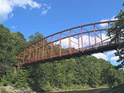
, which makes most of its northern border. The Bardwell's Ferry Bridge
Bardwell's Ferry Bridge
The Bardwell's Ferry Bridge, built in 1882, is an historic lenticular Truss bridge spanning the Deerfield River between the towns of Shelburne and Conway in Franklin County, Massachusetts. The bridge is listed on the National Register of Historic Places....
connects Conway to Shelburne
Shelburne, Massachusetts
Shelburne is a town in Franklin County, Massachusetts, United States. The population was 2,058 at the 2000 census. It is part of the Springfield, Massachusetts Metropolitan Statistical Area.The village of Shelburne Falls is located in the town.- History :...
across the Deerfield River. The town lies along the South River, which flows from Ashfield to the Deerfield River through the town, with many brooks feeding it as well as the nearby Mill River through Deerfield. The town is dotted with forests and hills, and is home to several state forests, including Conway State Forest, South River State Forest
South River State Forest
South River State Forest is located in Conway, Massachusetts. The forest is managed by the Department of Conservation and Recreation .-Description:...
, and the Poland Brook State Wildlife Management Area.
Route 116
Massachusetts Route 116
Route 116 is a south–north state highway in Massachusetts. The route runs from Springfield through mill towns, college towns and rural towns, crossing the Connecticut River three times before finally ending in Adams.-Route description:...
passes through the center of town, from Ashfield in the east towards Deerfield, along its way towards Springfield. Deerfield also has the nearest exits of Interstate 91
Interstate 91
Interstate 91 is an Interstate Highway in the New England region of the United States. It provides the primary north–south thoroughfare in the western part of New England...
, the nearest interstate highway to the town. A stretch of freight rail passes through the northern part of town, along the banks of the Deerfield River, between Deerfield and the Hoosac Tunnel
Hoosac Tunnel
The Hoosac Tunnel is a 4.75-mile-long railroad tunnel in western Massachusetts which passes through the Hoosac Range, an extension of Vermont's Green Mountains. Work began in 1848 and was finally completed in 1875...
to the west. The nearest passenger rail service can be reached at Amtrak
Amtrak
The National Railroad Passenger Corporation, doing business as Amtrak , is a government-owned corporation that was organized on May 1, 1971, to provide intercity passenger train service in the United States. "Amtrak" is a portmanteau of the words "America" and "track". It is headquartered at Union...
station in Amherst, with the nearest bus service in Deerfield. The nearest small airport is in Turners Falls
Montague, Massachusetts
Montague is a town in Franklin County, Massachusetts, United States. The population was 8,489 at the 2000 census. It is part of the Springfield, Massachusetts metropolitan statistical area....
, with the nearest national air service being at Bradley International Airport
Bradley International Airport
Bradley International Airport is a joint civil-military public airport located in Windsor Locks on the border with East Granby and Suffield, in Hartford County, Connecticut, United States. It is owned by the State of Connecticut....
in Windsor Locks
Windsor Locks, Connecticut
Windsor Locks is a town located in Hartford County, Connecticut, United States. As of the 2000 census, its population was 12,043. It is the site of Bradley International Airport, which serves the Greater Hartford-Springfield region. It is also the site of the New England Air Museum...
, Connecticut
Connecticut
Connecticut is a state in the New England region of the northeastern United States. It is bordered by Rhode Island to the east, Massachusetts to the north, and the state of New York to the west and the south .Connecticut is named for the Connecticut River, the major U.S. river that approximately...
.
Demographics
As of the censusCensus
A census is the procedure of systematically acquiring and recording information about the members of a given population. It is a regularly occurring and official count of a particular population. The term is used mostly in connection with national population and housing censuses; other common...
of 2000, there were 1,809 people, 692 households, and 512 families residing in the town. By population, Conway ranked twelfth of the twenty-six towns in Franklin County, and 295th of the 351 cities and towns in Massachusetts. The population density
Population density
Population density is a measurement of population per unit area or unit volume. It is frequently applied to living organisms, and particularly to humans...
was 48.0 people per square mile (18.5/km²), which ranked sixteenth in the county and 312th in the Commonwealth. There were 749 housing units at an average density of 19.9 per square mile (7.7/km²). The racial makeup of the town was 98.73% White, 0.17% African American, 0.22% Native American, 0.50% Asian, 0.11% from other races
Race (United States Census)
Race and ethnicity in the United States Census, as defined by the Federal Office of Management and Budget and the United States Census Bureau, are self-identification data items in which residents choose the race or races with which they most closely identify, and indicate whether or not they are...
, and 0.28% from two or more races. Hispanic or Latino of any race were 0.94% of the population.
There were 692 households out of which 36.3% had children under the age of 18 living with them, 61.4% were married couples
Marriage
Marriage is a social union or legal contract between people that creates kinship. It is an institution in which interpersonal relationships, usually intimate and sexual, are acknowledged in a variety of ways, depending on the culture or subculture in which it is found...
living together, 9.0% had a female householder with no husband present, and 25.9% were non-families. 18.8% of all households were made up of individuals and 5.2% had someone living alone who was 65 years of age or older. The average household size was 2.61 and the average family size was 3.01.
In the town the population was spread out with 25.2% under the age of 18, 5.3% from 18 to 24, 28.9% from 25 to 44, 31.2% from 45 to 64, and 9.5% who were 65 years of age or older. The median age was 40 years. For every 100 females there were 97.9 males. For every 100 females age 18 and over, there were 96.2 males.
The median income for a household in the town was $56,094, and the median income for a family was $62,917. Males had a median income of $41,146 versus $32,273 for females. The per capita income
Per capita income
Per capita income or income per person is a measure of mean income within an economic aggregate, such as a country or city. It is calculated by taking a measure of all sources of income in the aggregate and dividing it by the total population...
for the town was $25,605. About 2.5% of families and 3.5% of the population were below the poverty line, including 2.6% of those under age 18 and 4.0% of those age 65 or over.
Government
Conway employs the open town meetingOpen town meeting
An open town meeting is a form of town meeting in which all registered voters of a town may vote . This form of government is typical of smaller municipalities in the New England region of the United States....
form of government, and is led by a board of selectmen
Board of selectmen
The board of selectmen is commonly the executive arm of the government of New England towns in the United States. The board typically consists of three or five members, with or without staggered terms.-History:...
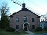
and an administrative assistant. The town offices, police station, fire station, post office and Field Memorial Library (donated to the town by Marshall Field and named for his family) are all located in the center of town. The nearest hospital, Franklin Medical Center, is located in Greenfield, as are most of the nearest state offices.
On the state level, Conway is represented in the Massachusetts House of Representatives
Massachusetts House of Representatives
The Massachusetts House of Representatives is the lower house of the Massachusetts General Court, the state legislature of the Commonwealth of Massachusetts. It is composed of 160 members elected from single-member electoral districts across the Commonwealth. Representatives serve two-year terms...
by the First Franklin district, which includes the southeastern third of Franklin County and towns in north central Hampshire County. In the Massachusetts Senate
Massachusetts Senate
The Massachusetts Senate is the upper house of the Massachusetts General Court, the bicameral state legislature of the Commonwealth of Massachusetts. The Senate comprises 40 elected members from 40 single-member senatorial districts in the state...
, the town is represented by the Berkshire, Hampshire and Franklin district, which includes all of Berkshire County, as well as much of western Franklin and Hampshire Counties. The town is patrolled by the Second (Shelburne Falls) Barracks of Troop "B" of the Massachusetts State Police
Massachusetts State Police
The Massachusetts State Police is an agency of the Commonwealth of Massachusetts' Executive Office of Public Safety and Security responsible for criminal law enforcement and traffic vehicle regulation across the state...
.
On the national level, Conway is represented in the United States House of Representatives
United States House of Representatives
The United States House of Representatives is one of the two Houses of the United States Congress, the bicameral legislature which also includes the Senate.The composition and powers of the House are established in Article One of the Constitution...
as part of Massachusetts's 1st congressional district
Massachusetts's 1st congressional district
Massachusetts's 1st congressional district is in western and central Massachusetts. The largest Massachusetts district in area, it covers about one-third of the state and is more rural than the rest. It has the state's highest point, Mount Greylock...
, and has been represented by John Olver
John Olver
John Walter Olver is the U.S. Representative for , serving since 1991. He is a member of the Democratic Party. Early in his career, he was a chemistry professor and served in both chambers of the Massachusetts General Court....
of Amherst
Amherst, Massachusetts
Amherst is a town in Hampshire County, Massachusetts, United States in the Connecticut River valley. As of the 2010 census, the population was 37,819, making it the largest community in Hampshire County . The town is home to Amherst College, Hampshire College, and the University of Massachusetts...
since June 1991. Massachusetts is currently represented in the United States Senate
United States Senate
The United States Senate is the upper house of the bicameral legislature of the United States, and together with the United States House of Representatives comprises the United States Congress. The composition and powers of the Senate are established in Article One of the U.S. Constitution. Each...
by Senators John Kerry
John Kerry
John Forbes Kerry is the senior United States Senator from Massachusetts, the 10th most senior U.S. Senator and chairman of the Senate Foreign Relations Committee. He was the presidential nominee of the Democratic Party in the 2004 presidential election, but lost to former President George W...
and Scott Brown
Scott Brown
Scott Brown is a United States senator.Scott Brown may also refer to:-Sportsmen:*Scott Brown , American college football coach of Kentucky State...
.
Education
Conway is a member of Frontier RegionalFrontier Regional School
-Academics:Frontier Regional runs on a semester system. Students can take 4-5 courses per semester; either 4 semester courses that meet everyday, or 3 semester courses that meet everyday and 2 quarter courses that meet every-other day...
and Union 38 School Districts, which also includes Deerfield, Whately and Sunderland. Each town operates its own elementary school, with Conway Grammar School serving the town's students from kindergarten through sixth grades. All four towns send seventh through twelfth grade students to Frontier Regional High School
Frontier Regional School
-Academics:Frontier Regional runs on a semester system. Students can take 4-5 courses per semester; either 4 semester courses that meet everyday, or 3 semester courses that meet everyday and 2 quarter courses that meet every-other day...
in Deerfield. There are several private, religious and charter schools located in the Greenfield and Deerfield area, with the nearest being the Deerfield Academy
Deerfield Academy
Deerfield Academy is an independent, coeducational boarding school in Deerfield, Massachusetts, United States. It is a four-year college-preparatory school with approximately 600 students and about 100 faculty, all of whom live on or near campus....
.
The nearest community college, Greenfield Community College
Greenfield Community College
Greenfield Community College is a two-year Community College in Greenfield, Massachusetts. It was founded in 1962, currently has an annual enrollment of 3,000, is regionally known for its art program, its small-town atmosphere, and its setting amid picturesque old farmland at the foot of...
, is located in Greenfield. The nearest state colleges are Massachusetts College of Liberal Arts
Massachusetts College of Liberal Arts
The Massachusetts College of Liberal Arts is a public, residential, liberal arts college that offers both undergraduate and graduate programs. Located in North Adams, Massachusetts, it is part of the state university system of Massachusetts. It is a member of the Council of Public Liberal Arts...
in North Adams, and the nearest state universities are Westfield State University and the University of Massachusetts Amherst
University of Massachusetts Amherst
The University of Massachusetts Amherst is a public research and land-grant university in Amherst, Massachusetts, United States and the flagship of the University of Massachusetts system...
. The nearest private colleges, including members of the Five Colleges
Five Colleges (Massachusetts)
The Five Colleges comprises four liberal arts colleges and one university in the Connecticut River Pioneer Valley of Western Massachusetts, totaling approximately 28,000 students. The schools belong to a consortium called Five Colleges, Incorporated, established in 1965...
and Seven Sisters
Seven Sisters (colleges)
The Seven Sisters are seven liberal arts colleges in the Northeastern United States that are historically women's colleges. They are Barnard College, Bryn Mawr College, Mount Holyoke College, Radcliffe College, Smith College, Vassar College, and Wellesley College. All were founded between 1837 and...
, are located southeast in the Northampton area.
Notable natives and residents
- John Avery, (1837–1887), educator, first citizen of the United States to be admitted to the Royal Asiatic SocietyRoyal Asiatic SocietyThe Royal Asiatic Society of Great Britain and Ireland was established, according to its Royal Charter of 11 August 1824, to further "the investigation of subjects connected with and for the encouragement of science, literature and the arts in relation to Asia." From its incorporation the Society...
- Marshall FieldMarshall FieldMarshall Field was founder of Marshall Field and Company, the Chicago-based department stores.-Life and career:...
, Marshall Field and Company founder - Holly HobbieHolly HobbieHolly Hobbie is an American writer and illustrator, and the name of a fictional character based on this person.Hobbie is the author of the popular Toot and Puddle children's books, and the creator of the character bearing her name...
, author of children's books and the creator of the fictional character that bears her name. - Archibald MacLeishArchibald MacLeishArchibald MacLeish was an American poet, writer, and the Librarian of Congress. He is associated with the Modernist school of poetry. He received three Pulitzer Prizes for his work.-Early years:...
(May 7, 1892 – April 20, 1982) American poet associated with the modernist school of poetry, writer, Librarian of Congress, three-time Pulitzer Prize winner - Erin McKeownErin McKeownErin McKeown is an American multi-instrumentalist and folk-rock singer/songwriter.McKeown began her career in the folk scene. She released her first album, Monday Morning Cold, on her own label , travelling throughout New England while still a student at Brown University in order to promote the...
, musician