

List of bridges on the National Register of Historic Places in Maryland
Encyclopedia
This is a list of bridge
s and tunnel
s on the National Register of Historic Places
in the U.S. state
of Maryland
.
Bridge
A bridge is a structure built to span physical obstacles such as a body of water, valley, or road, for the purpose of providing passage over the obstacle...
s and tunnel
Tunnel
A tunnel is an underground passageway, completely enclosed except for openings for egress, commonly at each end.A tunnel may be for foot or vehicular road traffic, for rail traffic, or for a canal. Some tunnels are aqueducts to supply water for consumption or for hydroelectric stations or are sewers...
s on the National Register of Historic Places
National Register of Historic Places
The National Register of Historic Places is the United States government's official list of districts, sites, buildings, structures, and objects deemed worthy of preservation...
in the U.S. state
U.S. state
A U.S. state is any one of the 50 federated states of the United States of America that share sovereignty with the federal government. Because of this shared sovereignty, an American is a citizen both of the federal entity and of his or her state of domicile. Four states use the official title of...
of Maryland
Maryland
Maryland is a U.S. state located in the Mid Atlantic region of the United States, bordering Virginia, West Virginia, and the District of Columbia to its south and west; Pennsylvania to its north; and Delaware to its east...
.
| Name | Image | Built | Listed | Location | County | Type |
|---|---|---|---|---|---|---|
| B & O Railroad Potomac River Crossing B & O Railroad Potomac River Crossing The Baltimore and Ohio Railroad Crossings at the Potomac River are a set of railroad bridges that span the Potomac River between Maryland Heights, Maryland and Harpers Ferry, West Virginia in the United States. Two bridges comprise the current crossing... |
 |
1894, 1931 | 1978-02-14 | Harpers Ferry, West Virginia Harpers Ferry, West Virginia Harpers Ferry is a historic town in Jefferson County, West Virginia, United States. In many books the town is called "Harper's Ferry" with an apostrophe.... 39°19′27"N 77°43′43"W |
Washington Washington County, Maryland Washington County is a county located in the western part of the U.S. state of Maryland, bordering southern Pennsylvania to the north, northern Virginia to the south, and the Eastern Panhandle of West Virginia to the south and west. As of the 2010 Census, its population is 147,430... |
|
| B & O Bridge Baltimore & Ohio Railroad Bridge, Antietam Creek The Baltimore & Ohio Railroad Bridge, Antietam Creek is a timber trestle bridge near Keedysville, Washington County, Maryland, United States. It carried the Washington County branch of the Baltimore and Ohio Railroad, later part of CSX Transportation, over the ravine formed by the Antietam Creek... |
1977-11-23 | Keedysville Keedysville, Maryland Keedysville is a town in Washington County, Maryland, United States. The population was 482 as of the 2000 Census. As of 1 July 2008, the U.S. Census Bureau estimated the town's population at 862, a 78.8% increase from 2000.-Geography:... 39°30′15"N 77°42′49"W |
Washington Washington County, Maryland Washington County is a county located in the western part of the U.S. state of Maryland, bordering southern Pennsylvania to the north, northern Virginia to the south, and the Eastern Panhandle of West Virginia to the south and west. As of the 2010 Census, its population is 147,430... |
|||
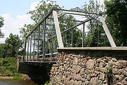
| Bennies Hill Road Bridge Bennies Hill Road Bridge Bennies Hill Road Bridge is a steel bowstring arch bridge over Catoctin Creek near Middletown, Maryland, United States. It is one of two remaining bridges of its type in Maryland that remains in their original locations. The bridge was restored in 2009.... |
1979-06-27 | Middletown Middletown, Maryland Middletown is a town in Frederick County, Maryland, United States. The population was 2,668 at the 2000 census. Middletown is a small, rural community steeped in American history... 39°24′34"N 77°34′12"W |
Frederick Frederick County, Maryland Frederick County is a county located in the western part of the U.S. state of Maryland, bordering the southern border of Pennsylvania and the northeastern border of Virginia. As of the 2010 Census, the population was 233,385.... |
Bowstring arch truss | ||
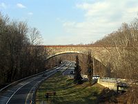
| Bloomington Viaduct Bloomington Viaduct The Bloomington Viaduct spans the Northern Branch of the Potomac River connecting Bloomington, Maryland to Mineral County, West Virginia. The sandstone railroad bridge features three full center arches, each with a 56 foot span and a 28 foot rise... |
1851, 1916 | 1976-11-21 | Bloomington Bloomington, Maryland Bloomington is an unincorporated town at the confluence of the North Branch Potomac River and Savage River in southeastern Garrett County, Maryland... 39°28′37"N 79°4′5"W |
Garrett Garrett County, Maryland Garrett County is the westernmost county of the U.S. state of Maryland. Created from Allegany County, Maryland in 1872 it was the last Maryland county to be formed. It was named for John Work Garrett , railroad executive, industrialist, and financier. Garrett served as president of the Baltimore... |
Multispan masonry bridge | |
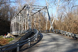
| Bollman Suspension and Trussed Bridge | 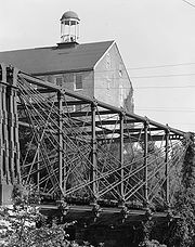 |
1869 | 1972-10-18 | Savage Savage, Maryland Savage is a historic town located in Howard County, Maryland, about south of Baltimore and north of Washington, D.C. It is situated close to the city of Laurel and to the planned community of Columbia.A rich vein of American industrial history lies in Savage... 39°8′5"N 76°49′31"W |
Howard Howard County, Maryland -2010:Whereas according to the 2010 U.S. Census Bureau:*62.2% White*17.5% Black*0.3% Native American*14.4% Asian*0.0% Native Hawaiian or Pacific Islander*3.6% Two or more races*2.0% Other races*5.8% Hispanic or Latino -2000:... |
Bollman Truss |
| Bullfrog Road Bridge Bullfrog Road Bridge The Bullfrog Road Bridge is a historic bridge near Taneytown, Frederick County, Maryland, United States. The bridge crosses the Monocacy River on Bullfrog Road. This bridge is a rare steel Parker through truss structure and is 183 feet in length and 16 feet-5 inches in width... |
1908 | 1978-11-21 | Taneytown Taneytown, Maryland Taneytown is a city in Carroll County, Maryland, United States. The population was 5,128 at the 2000 census. was founded in 1754. Of the town George Washington once wrote "Tan-nee town is but a small place with only the Street through wch. the road passes, built on... 39°41′44"N 77°14′25"W |
Frederick Frederick County, Maryland Frederick County is a county located in the western part of the U.S. state of Maryland, bordering the southern border of Pennsylvania and the northeastern border of Virginia. As of the 2010 Census, the population was 233,385.... |
Parker truss | |
| Carrollton Viaduct Carrollton Viaduct The Carrollton Viaduct, located over Gwynns Falls near Carroll Park in Baltimore, Maryland, is the first stone masonry bridge built for railroad use in the United States.... |
 |
1828, 1829 | 1971-11-11 | Baltimore 39°16′31"N 76°39′19"W |
Baltimore City | |
| Casselman's Bridge, National Road | 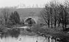 |
1813 | 1966-10-15 | Grantsville Grantsville, Maryland Grantsville is a town in Garrett County, Maryland, United States. The population was 619 at the 2000 census.-History:Grantsville, 1/2 mile west of the Casselman River, began as a small Amish and Mennonite settlement, called Tomlinson's or Little Crossing, along Braddock rd., which wound westward... |
Garrett Garrett County, Maryland Garrett County is the westernmost county of the U.S. state of Maryland. Created from Allegany County, Maryland in 1872 it was the last Maryland county to be formed. It was named for John Work Garrett , railroad executive, industrialist, and financier. Garrett served as president of the Baltimore... |
Single arch |
| Crum Road Bridge Crum Road Bridge The Crum Road Bridge is a historic bridge near Walkersville, Frederick County, Maryland, United States. It spans Israel Creek southeast of Walkersville. The bridge is an iron bowstring pony truss bridge that is 62 feet in length and 15.8 feet in width... |
1978-12-28 | Walkersville Walkersville, Maryland Walkersville is a town in Frederick County, Maryland, United States. The population was 5,805 per the 2010 census.-History:Crum Road Bridge was listed on the National Register of Historic Places in 1978... 39°28′47"N 77°19′39"W |
Frederick Frederick County, Maryland Frederick County is a county located in the western part of the U.S. state of Maryland, bordering the southern border of Pennsylvania and the northeastern border of Virginia. As of the 2010 Census, the population was 233,385.... |
Bowstring arch truss | ||
| Fourpoints Bridge Fourpoints Bridge The Fourpoints Bridge, near Emmitsburg, Maryland is a wrought iron bridge by the Wrought Iron Bridge Company of Canton, Ohio. The bridge is similar to the Poffenberger Road Bridge elsewhere in Frederick County. The 103-foot Pratt truss remains in daily use.... |
 |
1978-11-29 | Emmitsburg Emmitsburg, Maryland -Demographics:As of the census of 2000, there were 2,290 people, 811 households, and 553 families residing in the town. The population density was 1,992.9 people per square mile . There were 862 housing units at an average density of 750.2 per square mile... 39°40′17"N 77°18′4"W |
Frederick Frederick County, Maryland Frederick County is a county located in the western part of the U.S. state of Maryland, bordering the southern border of Pennsylvania and the northeastern border of Virginia. As of the 2010 Census, the population was 233,385.... |
Pratt truss | |
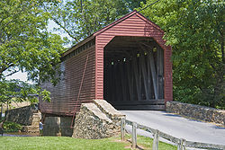
| Gilpin's Falls Covered Bridge Gilpin's Falls Covered Bridge The Gilpin's Falls Covered Bridge is a Burr arch through truss wooden covered bridge near North East, Cecil County, Maryland, United States. The bridge was constructed by local Cecil County bridgewright Joseph George Johnson in the autumn and winter of 1860/61 across Northeast Creek... |
ca. 1855 | 2008-12-03 | North East North East, Maryland North East is a town in Cecil County, Maryland, United States. The population was 2,733 at the 2000 census.-History:The Turkey Point Light Station was listed on the National Register of Historic Places in 2002... |
Cecil Cecil County, Maryland Cecil County is a county located in the U.S. state of Maryland. It is part of the Delaware Valley. It was named for Cæcilius Calvert, 2nd Baron Baltimore , who was the first Proprietary Governor of the colony of Maryland from 1632 until his death in 1675. The county seat is Elkton. The newspaper... |
Burr Arch Through Truss | |
| Howard Street Tunnel | 1890, 1895 | 1973-07-02 | Baltimore 39°18′17"N 76°37′15"W |
Baltimore City | Brick-lined tunnel Tunnel A tunnel is an underground passageway, completely enclosed except for openings for egress, commonly at each end.A tunnel may be for foot or vehicular road traffic, for rail traffic, or for a canal. Some tunnels are aqueducts to supply water for consumption or for hydroelectric stations or are sewers... with iron-arched centerings |
|
| Jericho Covered Bridge Jericho Covered Bridge The Jericho Covered Bridge is a Burr arch through truss wooden covered bridge near Jerusalem, Harford County and Kingsville, Baltimore County, in Maryland, United States and near historic Jerusalem Mill Village. The bridge was constructed in 1865 across the Little Gunpowder Falls. Renovations were... |
1865, 1937 | 1978-09-13 | Jerusalem, Kingsville Kingsville, Maryland Kingsville is a semi-rural, unincorporated community and a census-designated place in Baltimore County, Maryland, United States. It is a close-knit and rustic community bounded by the Little Gunpowder Falls river and the Big Gunpowder Falls river which join to form the Gunpowder... 39°27′34"N 76°23′16"W |
Baltimore Baltimore County, Maryland Baltimore County is a county located in the northern part of the US state of Maryland. In 2010, its population was 805,029. It is part of the Baltimore-Washington Metropolitan Area. Its county seat is Towson. The name of the county was derived from the barony of the Proprietor of the Maryland... , Harford Harford County, Maryland Harford County is a county in the U.S. state of Maryland. In 2010, its population was 244,826. Its county seat is Bel Air. Harford County forms part of the Baltimore-Washington Metropolitan Area.-History:... |
Burr Arch Through Truss | |
| LeGore Bridge LeGore Bridge Begun in 1898 in rural Frederick County, Maryland, the LeGore Bridge was completed and opened to the public in 1900. It was built and maintained by the owners of the LeGore Lime Company, including local businessman James William LeGore and his company advisor, Eugene Hammond. It is 340 feet in... |
1978-09-18 | Woodsboro Woodsboro, Maryland Woodsboro is a town in Frederick County, Maryland, United States that was granted to Joseph Wood in 1693. The population was 846 at the 2000 census.-History:... 39°34′50"N 77°18′50"W |
Frederick Frederick County, Maryland Frederick County is a county located in the western part of the U.S. state of Maryland, bordering the southern border of Pennsylvania and the northeastern border of Virginia. As of the 2010 Census, the population was 233,385.... |
Five-span stone arch | ||
| Lombard Street Bridge Lombard Street Bridge Lombard Street Bridge is a historic truss bridge located at Baltimore, Maryland, United States. It is an 88 foot cast iron span consisting of three lines of trusses—two outer trusses of composite cast and wrought iron in a diagonal Pratt design and a center composite bowstring truss of Pratt-system... |
1877, 1974 | 1972-09-27 | Baltimore 39°19′0"N 76°42′1"W |
Baltimore City | Water-main truss | |
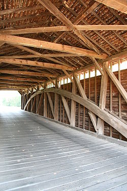
| Loys Station Covered Bridge Loys Station Covered Bridge The Loys Station Covered Bridge is a multiple king post wooden covered bridge near Thurmont, Maryland. The bridge was burned by an arsonist in 1991 and rebuilt using surviving framing. The original bridge spanned 90 feet in one span, but has since been modified with a pier at the middle of the... |
 |
1978-06-23 | Thurmont Thurmont, Maryland Thurmont is a town in Frederick County, Maryland, United States. The population was 5,588 at the 2000 census. The town is located in the northern part of Frederick County , approximately ten miles from the Pennsylvania border, along U.S. Highway 15... 39°36′26"N 77°21′8"W |
Frederick Frederick County, Maryland Frederick County is a county located in the western part of the U.S. state of Maryland, bordering the southern border of Pennsylvania and the northeastern border of Virginia. As of the 2010 Census, the population was 233,385.... |
Covered Covered bridge A covered bridge is a bridge with enclosed sides and a roof, often accommodating only a single lane of traffic. Most covered bridges are wooden; some newer ones are concrete or metal with glass sides... Multiple king post |
|
| Old Mill Road Bridge Old Mill Road Bridge The Old Mill Road Bridge is a historic bridge near Rocky Ridge, Frederick County, Maryland, United States. The bridge spans Owens Creek southwest of Rocky Ridge on Old Mill Road. It is a Pratt Half-Hip through truss structure in a single span of 69 feet in length and 16 feet wide... |
1882 | 1979-03-07 | Rocky Ridge Rocky Ridge, Maryland Rocky Ridge is an unincorporated community in Frederick County, Maryland, United States. Old Mill Road Bridge was listed on the National Register of Historic Places in 1979.-External links:*... 39°36′7"N 77°20′19"W |
Frederick Frederick County, Maryland Frederick County is a county located in the western part of the U.S. state of Maryland, bordering the southern border of Pennsylvania and the northeastern border of Virginia. As of the 2010 Census, the population was 233,385.... |
Pratt truss | |
| Patterson Viaduct Ruins | 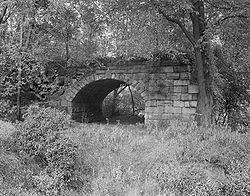 |
1829 | 1976-06-03 | Catonsville Catonsville, Maryland According to the United States Census Bureau, the CDP has a total area of , all of it land.-Demographics:In 2010 Catonsville had a population of 41,567... , Ilchester Ilchester, Maryland Ilchester is an unincorporated community in Howard County, Maryland. It was named after the village of Ilchester in England.-History:Located about southeast of Ellicott City, Ilchester was settled by the Ellicott family in the late 18th century... 39°15′0"N 76°45′51"W |
Baltimore Baltimore County, Maryland Baltimore County is a county located in the northern part of the US state of Maryland. In 2010, its population was 805,029. It is part of the Baltimore-Washington Metropolitan Area. Its county seat is Towson. The name of the county was derived from the barony of the Proprietor of the Maryland... , Howard Howard County, Maryland -2010:Whereas according to the 2010 U.S. Census Bureau:*62.2% White*17.5% Black*0.3% Native American*14.4% Asian*0.0% Native Hawaiian or Pacific Islander*3.6% Two or more races*2.0% Other races*5.8% Hispanic or Latino -2000:... |
Masonry Arch Bridge |
| Poffenberger Road Bridge Poffenberger Road Bridge The Poffenberger Road Bridge, near Jefferson, Maryland is a wrought iron bridge by the Wrought Iron Bridge Company of Canton, Ohio. The bridge is similar to the Fourpoints Bridge elsewhere in Frederick County. The bridge is a single-span double-intersection Pratt truss... |
 |
1878 | 1978-11-29 | Middletown Middletown, Maryland Middletown is a town in Frederick County, Maryland, United States. The population was 2,668 at the 2000 census. Middletown is a small, rural community steeped in American history... 39°22′54"N 77°34′18"W |
Frederick Frederick County, Maryland Frederick County is a county located in the western part of the U.S. state of Maryland, bordering the southern border of Pennsylvania and the northeastern border of Virginia. As of the 2010 Census, the population was 233,385.... |
Pratt or Whipple thru truss |
| Roddy Road Covered Bridge Roddy Road Covered Bridge The Roddy Road Covered Bridge is a small, one lane king post wooden covered bridge near Thurmont, Frederick County, Maryland. It crosses Owen’s Creek near Thurmont. It is 40 feet long, 16 feet wide, with a 12 foot-8 inch clearance... |
1978-06-23 | Thurmont Thurmont, Maryland Thurmont is a town in Frederick County, Maryland, United States. The population was 5,588 at the 2000 census. The town is located in the northern part of Frederick County , approximately ten miles from the Pennsylvania border, along U.S. Highway 15... 39°38′26"N 77°23′39"W |
Frederick Frederick County, Maryland Frederick County is a county located in the western part of the U.S. state of Maryland, bordering the southern border of Pennsylvania and the northeastern border of Virginia. As of the 2010 Census, the population was 233,385.... |
Covered Covered bridge A covered bridge is a bridge with enclosed sides and a roof, often accommodating only a single lane of traffic. Most covered bridges are wooden; some newer ones are concrete or metal with glass sides... Single king post |
||
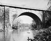
| Thomas Viaduct, Baltimore & Ohio Railroad | 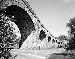 |
1835 | 1966-10-15 | Relay 39°13′19"N 76°42′49"W |
Baltimore Baltimore County, Maryland Baltimore County is a county located in the northern part of the US state of Maryland. In 2010, its population was 805,029. It is part of the Baltimore-Washington Metropolitan Area. Its county seat is Towson. The name of the county was derived from the barony of the Proprietor of the Maryland... , Howard Howard County, Maryland -2010:Whereas according to the 2010 U.S. Census Bureau:*62.2% White*17.5% Black*0.3% Native American*14.4% Asian*0.0% Native Hawaiian or Pacific Islander*3.6% Two or more races*2.0% Other races*5.8% Hispanic or Latino -2000:... |
Multiple stone arch |
| Union Arch Bridge (Cabin John Aqueduct) Union Arch Bridge The Union Arch Bridge, also called the "Cabin John Bridge," is a historic masonry structure in Cabin John, Maryland. It was designed as part of the Washington Aqueduct and as a roadway bridge. The bridge construction began in 1857 and was completed in 1864. The roadway surface was added later... |
 |
1864 | 1973-02-28 | Cabin John Cabin John, Maryland Cabin John is a census-designated place and an unincorporated area in Montgomery County, Maryland, United States. The placename is a corruption of its original name of "Captain John's Mills."-Geography:... 38°58′22.28"N 77°8′52.69"W |
Mongtomery Montgomery County, Maryland Montgomery County is a county in the U.S. state of Maryland, situated just to the north of Washington, D.C., and southwest of the city of Baltimore. It is one of the most affluent counties in the United States, and has the highest percentage of residents over 25 years of age who hold post-graduate... |
Masonry arch |
| Utica Covered Bridge Utica Covered Bridge The Utica Road Covered Bridge is a Burr truss wooden covered bridge located near Lewistown, Maryland. Originally built in 1834, it spanned the Monocacy River at the Devilbiss Bridge crossing. An 1889 flood damaged the bridge and the surviving half was moved to Fishing Creek in 1891... |
 |
1978-06-23 | Thurmont Thurmont, Maryland Thurmont is a town in Frederick County, Maryland, United States. The population was 5,588 at the 2000 census. The town is located in the northern part of Frederick County , approximately ten miles from the Pennsylvania border, along U.S. Highway 15... 39°31′28"N 77°23′46"W |
Frederick Frederick County, Maryland Frederick County is a county located in the western part of the U.S. state of Maryland, bordering the southern border of Pennsylvania and the northeastern border of Virginia. As of the 2010 Census, the population was 233,385.... |
Covered Covered bridge A covered bridge is a bridge with enclosed sides and a roof, often accommodating only a single lane of traffic. Most covered bridges are wooden; some newer ones are concrete or metal with glass sides... Burr arch truss |
|
| Waverly Street Bridge Waverly Street Bridge The Waverly Street Bridge, also called the Westernport Bowstring Arch Truss Bridge, is a historic steel truss bridge at Westernport, Allegany County, Maryland, United States. It carries vehicular traffic on Waverly Street over George's Creek. The bridge has a span length of 108 feet... |
1892 | 1984-09-07 | Westernport Westernport, Maryland Westernport is a town in Allegany County, Maryland, United States, located along the Georges Creek Valley. It is part of the Cumberland, MD-WV Metropolitan Statistical Area. The population was 2,104 at the 2000 census.-History:... 39°29′23"N 79°2′34"W |
Allegany Allegany County, Maryland Allegany County is a county located in the northwestern part of the US state of Maryland. It is part of the Cumberland, MD-WV Metropolitan Statistical Area. As of 2010, the population was 75,087. Its county seat is Cumberland... |
bowstring arch truss | |
| Wilson's Bridge Wilson's Bridge Wilson's Bridge is a bridge near Hagerstown, Washington County, Maryland, United States. It originally carried the Hagerstown and Conococheague Turnpike, the National Pike, across the Conococheague Creek seven miles west of Hagerstown. The five-arched structure, the longest of the county's stone... |
1819 | 1982-03-15 | Hagerstown Hagerstown, Maryland Hagerstown is a city in northwestern Maryland, United States. It is the county seat of Washington County, and, by many definitions, the largest city in a region known as Western Maryland. The population of Hagerstown city proper at the 2010 census was 39,662, and the population of the... 39°39′27"N 77°50′53"W |
Washington Washington County, Maryland Washington County is a county located in the western part of the U.S. state of Maryland, bordering southern Pennsylvania to the north, northern Virginia to the south, and the Eastern Panhandle of West Virginia to the south and west. As of the 2010 Census, its population is 147,430... |