

List of bridges on the National Register of Historic Places in Arizona
Encyclopedia
This is a list of bridge
s and tunnel
s on the National Register of Historic Places
in the U.S. state
of Arizona
.
Bridge
A bridge is a structure built to span physical obstacles such as a body of water, valley, or road, for the purpose of providing passage over the obstacle...
s and tunnel
Tunnel
A tunnel is an underground passageway, completely enclosed except for openings for egress, commonly at each end.A tunnel may be for foot or vehicular road traffic, for rail traffic, or for a canal. Some tunnels are aqueducts to supply water for consumption or for hydroelectric stations or are sewers...
s on the National Register of Historic Places
National Register of Historic Places
The National Register of Historic Places is the United States government's official list of districts, sites, buildings, structures, and objects deemed worthy of preservation...
in the U.S. state
U.S. state
A U.S. state is any one of the 50 federated states of the United States of America that share sovereignty with the federal government. Because of this shared sovereignty, an American is a citizen both of the federal entity and of his or her state of domicile. Four states use the official title of...
of Arizona
Arizona
Arizona ; is a state located in the southwestern region of the United States. It is also part of the western United States and the mountain west. The capital and largest city is Phoenix...
.
| Name | Image | Built | Listed | Location | County | Type |
|---|---|---|---|---|---|---|
| 1931 Tempe Bridge | 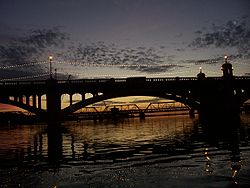 |
1931 | 1981-08-13 | Tempe Tempe, Arizona Tempe is a city in Maricopa County, Arizona, USA, with the Census Bureau reporting a 2010 population of 161,719. The city is named after the Vale of Tempe in Greece. Tempe is located in the East Valley section of metropolitan Phoenix; it is bordered by Phoenix and Guadalupe on the west, Scottsdale... 33°25′49"N 111°56′22"W |
Maricopa Maricopa County, Arizona -2010:Whereas according to the 2010 U.S. Census Bureau:*73.0% White*5.0% Black*2.1% Native American*3.5% Asian*0.2% Native Hawaiian or Pacific Islander*3.5% Two or more races*12.7% Other races*29.6% Hispanic or Latino -2000:... |
Multiple arch Arch bridge An arch bridge is a bridge with abutments at each end shaped as a curved arch. Arch bridges work by transferring the weight of the bridge and its loads partially into a horizontal thrust restrained by the abutments at either side... |
| Alchesay Canyon Bridge | 1904, 1905 | 1988-09-30 | Roosevelt Roosevelt, Arizona Roosevelt is an unincorporated community in Gila County in the U.S. State of Arizona, located on the south shore of Theodore Roosevelt Lake. Roosevelt has a ZIP Code of 85545; in 2000, the population of the 85545 ZCTA was 616.... 33°40′5"N 111°9′30"W |
Maricopa Maricopa County, Arizona -2010:Whereas according to the 2010 U.S. Census Bureau:*73.0% White*5.0% Black*2.1% Native American*3.5% Asian*0.2% Native Hawaiian or Pacific Islander*3.5% Two or more races*12.7% Other races*29.6% Hispanic or Latino -2000:... |
Filled spandrel arch | |
| Allentown Bridge | 1923 | 1988-09-30 | Houck Houck, Arizona Houck is a census-designated place in Apache County, Arizona, United States. The population was 1,087 at the 2000 census.-Geography:Houck is located at .... 35°16′51"N 109°9′16"W |
Apache Apache County, Arizona -2010:Whereas according to the 2010 U.S. Census Bureau:*23.3% White*0.2% Black*72.9% Native American*0.3% Asian*0.0% Native Hawaiian or Pacific Islander*2.0% Two or more races*1.3% Other races*5.8% Hispanic or Latino -2000:... |
Pratt deck truss | |
| Antelope Hill Highway Bridge | 1915, 1920 | 1979-06-28 | Tacna Tacna, Arizona Tacna is a census-designated place in Yuma County, Arizona, United States. The population was 555 at the 2000 census. It is part of the Yuma Metropolitan Statistical Area.-Geography:Tacna is located at .... 32°43′8"N 114°0′43"W |
Yuma Yuma County, Arizona -2010:Whereas according to the 2010 U.S. Census Bureau:*70.4% White*2.0% Black*1.6% Native American*1.2% Asian*0.2% Native Hawaiian or Pacific Islander*3.8% Two or more races*20.8% Other races*59.7% Hispanic or Latino -2000:... |
Concrete girder | |
| Black Gap Bridge | 1921 | 1988-09-30 | Clifton Clifton, Arizona Clifton is a town in and the county seat of Greenlee County, Arizona, United States, along the San Francisco River. The population of the town was 3,311 at the 2010 census. It was a site of the Arizona Copper Mine Strike of 1983.... 32°56′47"N 109°19′7"W |
Greenlee Greenlee County, Arizona -2010:Whereas according to the 2010 U.S. Census Bureau:*77.2% White*1.1% Black*2.3% Native American*0.5% Asian*0.1% Native Hawaiian or Pacific Islander*3.8% Two or more races*15.0% Other races*47.9% Hispanic or Latino -2000:... |
Concrete slab | |
| Black River Bridge | 1912, 1929 | 1988-09-30 | Carrizo 33°42′46"N 110°12′40"W |
Gila Gila County, Arizona -2010:Whereas according to the 2010 U.S. Census Bureau:*76.8% White*0.4% Black*14.8% Native American*0.5% Asian*0.1% Native Hawaiian or Pacific Islander*2.0% Two or more races*5.4% Other races*17.9% Hispanic or Latino -2000:... |
Deck truss | |
| Boulder Creek Bridge | 1937 | 1989-03-31 | Tortilla Flat Tortilla Flat, Arizona Tortilla Flat is a small unincorporated community in far eastern Maricopa County, Arizona, United States. It is located in the central part of the state, northeast of Apache Junction. It is the last surviving stagecoach stop along the Apache Trail. According to the Gross Management Department of... 33°32′1"N 111°25′23"W |
Maricopa Maricopa County, Arizona -2010:Whereas according to the 2010 U.S. Census Bureau:*73.0% White*5.0% Black*2.1% Native American*3.5% Asian*0.2% Native Hawaiian or Pacific Islander*3.5% Two or more races*12.7% Other races*29.6% Hispanic or Latino -2000:... |
||
| Broadway Bridge | 1917 | 1988-09-30 | Clarkdale Clarkdale, Arizona Clarkdale is a town in Yavapai County, Arizona, United States. According to 2006 Census Bureau estimates, the population of the town is 3,836.Clarkdale, formerly a mining town, is now largely a retirement community with an eye for the arts.-History:... 34°46′27"N 112°3′19"W |
Yavapai Yavapai County, Arizona -2010:Whereas according to the 2010 U.S. Census Bureau:*89.3% White*0.6% Black*1.7% Native American*0.8% Asian*0.1% Native Hawaiian or Pacific Islander*2.5% Two or more races*5.0% Other races*13.6% Hispanic or Latino -2000:... |
Skewed concrete slab | |
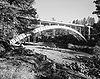
| Cameron Suspension Bridge | 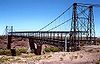 |
1911 | 1986-06-05 | Cameron Cameron, Arizona Cameron is a census-designated place in Coconino County, Arizona, United States. The population was 978 at the 2000 census. Most of the town's economy is tourist food and craft stalls, restaurants, and other services for north-south traffic from Flagstaff and Page... 35°52′38"N 111°24′40"W |
Coconino Coconino County, Arizona -2010:Whereas according to the 2010 U.S. Census Bureau:*61.7% White*1.2% Black*27.3% Native American*1.4% Asian*0.1% Native Hawaiian or Pacific Islander*3.1% Two or more races*5.2% Other races*13.5% Hispanic or Latino -2000:... |
Suspension Suspension bridge A suspension bridge is a type of bridge in which the deck is hung below suspension cables on vertical suspenders. Outside Tibet and Bhutan, where the first examples of this type of bridge were built in the 15th century, this type of bridge dates from the early 19th century... -truss Truss bridge A truss bridge is a bridge composed of connected elements which may be stressed from tension, compression, or sometimes both in response to dynamic loads. Truss bridges are one of the oldest types of modern bridges... hybrid |
| Canyon Diablo Bridge | 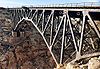 |
1914, 1915, ca. 1930 | 1988-09-30 | Winona Winona, Arizona Winona is a small unincorporated community in Coconino County in the northern part of the U.S. state of Arizona.It is located along U.S. Route 66 and was made famous in the song " Route 66"... 35°6′56"N 111°5′41"W |
Coconino Coconino County, Arizona -2010:Whereas according to the 2010 U.S. Census Bureau:*61.7% White*1.2% Black*27.3% Native American*1.4% Asian*0.1% Native Hawaiian or Pacific Islander*3.1% Two or more races*5.2% Other races*13.5% Hispanic or Latino -2000:... |
Steel arch |
| Canyon Padre Bridge | 1913, 1914 | 1988-09-30 | Flagstaff Flagstaff, Arizona Flagstaff is a city located in northern Arizona, in the southwestern United States. In 2010, the city's population was 65,870. The population of the Metropolitan Statistical Area was at 134,421 in 2010. It is the county seat of Coconino County... 35°9′44"N 111°17′12"W |
Coconino Coconino County, Arizona -2010:Whereas according to the 2010 U.S. Census Bureau:*61.7% White*1.2% Black*27.3% Native American*1.4% Asian*0.1% Native Hawaiian or Pacific Islander*3.1% Two or more races*5.2% Other races*13.5% Hispanic or Latino -2000:... |
Concrete Luten arch Luten arch A Luten arch is a patented concrete arch design for bridges, designed by Daniel B. Luten, of Indianapolis. Luten was awarded more than 30 patents for his improvements of the Luten arch design.... |
|
| Cedar Canyon Bridge Cedar Canyon Bridge The Cedar Canyon Bridge is a steel arch highway bridge on US 60 near Show Low, Arizona. The span ribbed girder arch bridge was built in 1937–38 with a total length of... |
 |
1937 | 1988-09-30 | Show Low Show Low, Arizona Winters in Show Low bring highs between 45°F and 55°F , with lows usually below freezing between November and March, averaging in the 20s December through February, and in the low 30s for November and March.... 34°3′32"N 110°12′33"W |
Navajo Navajo County, Arizona -2010:Whereas according to the 2010 U.S. Census Bureau:*49.3% White*0.9% Black*43.4% Native American*0.5% Asian*0.1% Native Hawaiian or Pacific Islander*2.5% Two or more races*3.3% Other races*10.8% Hispanic or Latino -2000:... |
Arch Arch bridge An arch bridge is a bridge with abutments at each end shaped as a curved arch. Arch bridges work by transferring the weight of the bridge and its loads partially into a horizontal thrust restrained by the abutments at either side... |
| Chevelon Creek Bridge | 1912, 1913 | 1983-12-08 | Winslow Winslow, Arizona -Demographics:As of the census of 2000, there were 9,520 people, 2,754 households, and 1,991 families residing in the city. The population density was 773.1 people per square mile . There were 3,198 housing units at an average density of 259.7 per square mile... 34°55′24"N 110°31′43"W |
Navajo Navajo County, Arizona -2010:Whereas according to the 2010 U.S. Census Bureau:*49.3% White*0.9% Black*43.4% Native American*0.5% Asian*0.1% Native Hawaiian or Pacific Islander*2.5% Two or more races*3.3% Other races*10.8% Hispanic or Latino -2000:... |
Pony truss | |
| Cienega Bridge | 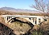 |
1921 | 1988-09-30 | Vail Vail, Arizona Vail is a census-designated place in Pima County, Arizona, United States. The population was 10,208 at the 2010 census. The area is known for the nearby Colossal Cave, a large cave system, and the Rincon Mountains District of Saguaro National Park, a top tourism spot within Arizona.Vail was... 32°1′11"N 110°38′43"W |
Pima Pima County, Arizona -2010:Whereas according to the 2010 U.S. Census Bureau:*74.3% White*3.5% Black*3.3% Native American*2.6% Asian*0.2% Native Hawaiian or Pacific Islander*3.7% Two or more races*12.4% Other races*34.6% Hispanic or Latino -2000:... |
Open spandrel concrete arch Arch bridge An arch bridge is a bridge with abutments at each end shaped as a curved arch. Arch bridges work by transferring the weight of the bridge and its loads partially into a horizontal thrust restrained by the abutments at either side... |
| Cordova Avenue Bridge | 1921 | 1989-03-31 | Miami Miami, Arizona Miami is a town in Gila County, Arizona, United States. Miami is a classic Western copper boomtown, though the copper mines are largely dormant now... 33°23′44"N 110°52′32"W |
Gila Gila County, Arizona -2010:Whereas according to the 2010 U.S. Census Bureau:*76.8% White*0.4% Black*14.8% Native American*0.5% Asian*0.1% Native Hawaiian or Pacific Islander*2.0% Two or more races*5.4% Other races*17.9% Hispanic or Latino -2000:... |
Luten arch Luten arch A Luten arch is a patented concrete arch design for bridges, designed by Daniel B. Luten, of Indianapolis. Luten was awarded more than 30 patents for his improvements of the Luten arch design.... |
|
| Corduroy Creek Bridge Corduroy Creek Bridge The Corduroy Creek Bridge was a steel arch highway bridge on US 60 near Show Low, Arizona. The 180-foot span ribbed girder arch bridge was built in 1937-38 with a total length of 250 feet... |
 |
1937 | 1988-09-30 | Show Low Show Low, Arizona Winters in Show Low bring highs between 45°F and 55°F , with lows usually below freezing between November and March, averaging in the 20s December through February, and in the low 30s for November and March.... 34°6′24"N 110°9′10"W |
Navajo Navajo County, Arizona -2010:Whereas according to the 2010 U.S. Census Bureau:*49.3% White*0.9% Black*43.4% Native American*0.5% Asian*0.1% Native Hawaiian or Pacific Islander*2.5% Two or more races*3.3% Other races*10.8% Hispanic or Latino -2000:... |
Arch Arch bridge An arch bridge is a bridge with abutments at each end shaped as a curved arch. Arch bridges work by transferring the weight of the bridge and its loads partially into a horizontal thrust restrained by the abutments at either side... |
| Dead Indian Canyon Bridge | 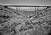 |
1933 | 1988-09-30 | Desert View 35°55′58"N 111°38′27"W |
Coconino Coconino County, Arizona -2010:Whereas according to the 2010 U.S. Census Bureau:*61.7% White*1.2% Black*27.3% Native American*1.4% Asian*0.1% Native Hawaiian or Pacific Islander*3.1% Two or more races*5.2% Other races*13.5% Hispanic or Latino -2000:... |
Warren deck truss |
| Dead Indian Canyon Bridge | 1934 | 1988-09-30 | Desert View 35°55′58"N 111°38′27"W |
Coconino Coconino County, Arizona -2010:Whereas according to the 2010 U.S. Census Bureau:*61.7% White*1.2% Black*27.3% Native American*1.4% Asian*0.1% Native Hawaiian or Pacific Islander*3.1% Two or more races*5.2% Other races*13.5% Hispanic or Latino -2000:... |
Warren deck truss | |
| Devil's Canyon Bridge | 1921, 1922 | 1988-09-30 | Superior 33°19′39"N 111°1′54"W |
Pinal Pinal County, Arizona -2010:Whereas according to the 2010 U.S. Census Bureau:*72.4% White*4.6% Black*5.6% Native American*1.7% Asian*0.4% Native Hawaiian or Pacific Islander*3.8% Two or more races*11.5% Other races*28.5% Hispanic or Latino -2000:... |
Filled spandrel arch | |
| Douglas Underpass | 1936 | 1988-09-30 | Douglas Douglas, Arizona Douglas is a city in Cochise County, Arizona, United States. Douglas has a border crossing with Mexico and a history of mining.The population was 14,312 at the 2000 census... 31°21′1"N 109°33′17"W |
Cochise Cochise County, Arizona -2010:Whereas according to the 2010 U.S. Census Bureau:*78.5% White*4.2% Black*1.2% Native American*1.9% Asian*0.3% Native Hawaiian or Pacific Islander*4.0% Two or more races*9.6% Other races*32.4% Hispanic or Latino -2000:... |
Concrete slab | |
| Fish Creek Bridge | 1923 | 1988-09-30 | Tortilla Flat Tortilla Flat, Arizona Tortilla Flat is a small unincorporated community in far eastern Maricopa County, Arizona, United States. It is located in the central part of the state, northeast of Apache Junction. It is the last surviving stagecoach stop along the Apache Trail. According to the Gross Management Department of... 33°32′14"N 111°17′46"W |
Maricopa Maricopa County, Arizona -2010:Whereas according to the 2010 U.S. Census Bureau:*73.0% White*5.0% Black*2.1% Native American*3.5% Asian*0.2% Native Hawaiian or Pacific Islander*3.5% Two or more races*12.7% Other races*29.6% Hispanic or Latino -2000:... |
Pony truss | |
| Fossil Creek Bridge Fossil Creek Bridge Fossil Creek Bridge is a bridge built in Arizona in 1924. It brings Fossil Creek Road across Fossil Creek crossing between Yavapai County, Arizona and Gila County, Arizona... |
1924, 1925 | 1988-09-30 | Camp Verde Camp Verde, Arizona Camp Verde is a town in Yavapai County, Arizona, United States. According to 2006 Census Bureau estimates, the population of the town is 10,610.... 34°23′39"N 111°37′45"W |
Gila Gila County, Arizona -2010:Whereas according to the 2010 U.S. Census Bureau:*76.8% White*0.4% Black*14.8% Native American*0.5% Asian*0.1% Native Hawaiian or Pacific Islander*2.0% Two or more races*5.4% Other races*17.9% Hispanic or Latino -2000:... , Yavapai Yavapai County, Arizona -2010:Whereas according to the 2010 U.S. Census Bureau:*89.3% White*0.6% Black*1.7% Native American*0.8% Asian*0.1% Native Hawaiian or Pacific Islander*2.5% Two or more races*5.0% Other races*13.6% Hispanic or Latino -2000:... |
Filled spandrel arch | |
| Fourth Avenue Underpass | 1916 | 1988-09-30 | Tucson Tucson, Arizona Tucson is a city in and the county seat of Pima County, Arizona, United States. The city is located 118 miles southeast of Phoenix and 60 miles north of the U.S.-Mexico border. The 2010 United States Census puts the city's population at 520,116 with a metropolitan area population at 1,020,200... 32°13′22"N 110°57′54"W |
Pima Pima County, Arizona -2010:Whereas according to the 2010 U.S. Census Bureau:*74.3% White*3.5% Black*3.3% Native American*2.6% Asian*0.2% Native Hawaiian or Pacific Islander*3.7% Two or more races*12.4% Other races*34.6% Hispanic or Latino -2000:... |
Concrete girder | |
| Gila Bend Overpass | 1934 | 1988-09-30 | Gila Bend Gila Bend, Arizona Gila Bend , founded in 1872, is a town in Maricopa County, Arizona, United States. The town is named for an approximately 90-degree bend in the Gila River, which is close to but not precisely at the community's current location... 32°56′58"N 112°41′46"W |
Maricopa Maricopa County, Arizona -2010:Whereas according to the 2010 U.S. Census Bureau:*73.0% White*5.0% Black*2.1% Native American*3.5% Asian*0.2% Native Hawaiian or Pacific Islander*3.5% Two or more races*12.7% Other races*29.6% Hispanic or Latino -2000:... |
Skewed steel deck girder | |
| Gila River Bridge | 1918 | 1988-09-30 | Clifton Clifton, Arizona Clifton is a town in and the county seat of Greenlee County, Arizona, United States, along the San Francisco River. The population of the town was 3,311 at the 2010 census. It was a site of the Arizona Copper Mine Strike of 1983.... 32°57′54"N 109°18′31"W |
Greenlee Greenlee County, Arizona -2010:Whereas according to the 2010 U.S. Census Bureau:*77.2% White*1.1% Black*2.3% Native American*0.5% Asian*0.1% Native Hawaiian or Pacific Islander*3.8% Two or more races*15.0% Other races*47.9% Hispanic or Latino -2000:... |
Luten arch Luten arch A Luten arch is a patented concrete arch design for bridges, designed by Daniel B. Luten, of Indianapolis. Luten was awarded more than 30 patents for his improvements of the Luten arch design.... |
|
| Gillespie Dam Highway Bridge | 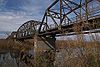 |
1926, 1927 | 1981-05-05 | Gila Bend Gila Bend, Arizona Gila Bend , founded in 1872, is a town in Maricopa County, Arizona, United States. The town is named for an approximately 90-degree bend in the Gila River, which is close to but not precisely at the community's current location... 33°13′38"N 112°46′7"W |
Maricopa Maricopa County, Arizona -2010:Whereas according to the 2010 U.S. Census Bureau:*73.0% White*5.0% Black*2.1% Native American*3.5% Asian*0.2% Native Hawaiian or Pacific Islander*3.5% Two or more races*12.7% Other races*29.6% Hispanic or Latino -2000:... |
Camelback through truss |
| Hassayampa River Bridge | 1929 | 1988-09-30 | Hassayampa Hassayampa, Arizona Hassayampa is a place in Arizona on the both banks of the Hassayampa River along the Southern Pacific Railway. It was about four miles west of Palo Verde, Arizona and slightly east of Dixie, Arizona and Arlington, Arizona.... 33°20′54"N 112°43′17"W |
Maricopa Maricopa County, Arizona -2010:Whereas according to the 2010 U.S. Census Bureau:*73.0% White*5.0% Black*2.1% Native American*3.5% Asian*0.2% Native Hawaiian or Pacific Islander*3.5% Two or more races*12.7% Other races*29.6% Hispanic or Latino -2000:... |
Concrete slab and girder | |
| Hell Canyon Bridge | 1923 | 1988-09-30 | Drake Drake, Arizona Drake is an unincorporated community in Yavapai County, Arizona, United States, and a station on the Burlington Northern and Santa Fe Railway. Drake is also the junction and western terminus of the Verde Canyon Railroad... 34°58′45"N 112°22′54"W |
Yavapai Yavapai County, Arizona -2010:Whereas according to the 2010 U.S. Census Bureau:*89.3% White*0.6% Black*1.7% Native American*0.8% Asian*0.1% Native Hawaiian or Pacific Islander*2.5% Two or more races*5.0% Other races*13.6% Hispanic or Latino -2000:... |
Concrete slab and girder | |
| Hereford Bridge | 1912, 1927 | 1988-09-30 | Hereford Hereford, Arizona Hereford is an unincorporated community in Cochise County along the San Pedro Riparian National Conservation Area in the southern part of the U.S. state of Arizona. It is south of Sierra Vista and is a part of the Sierra Vista-Douglas micropolitan area... 31°26′18"N 110°6′26"W |
Cochise Cochise County, Arizona -2010:Whereas according to the 2010 U.S. Census Bureau:*78.5% White*4.2% Black*1.2% Native American*1.9% Asian*0.3% Native Hawaiian or Pacific Islander*4.0% Two or more races*9.6% Other races*32.4% Hispanic or Latino -2000:... |
Pony truss | |
| Holbrook Bridge | 1916 | 1988-09-30 | Holbrook Holbrook, Arizona -Historical events:*During 1881 & 1882, railroad tracks were laid down and a railroad station was built. The community was then named Holbrook after the first engineer of the Atlantic and Pacific Railroad... 34°53′6"N 110°6′35"W |
Navajo Navajo County, Arizona -2010:Whereas according to the 2010 U.S. Census Bureau:*49.3% White*0.9% Black*43.4% Native American*0.5% Asian*0.1% Native Hawaiian or Pacific Islander*2.5% Two or more races*3.3% Other races*10.8% Hispanic or Latino -2000:... |
Luten arch Luten arch A Luten arch is a patented concrete arch design for bridges, designed by Daniel B. Luten, of Indianapolis. Luten was awarded more than 30 patents for his improvements of the Luten arch design.... |
|
| Holbrook Bridge |  |
1928 | 1989-03-31 | Holbrook Holbrook, Arizona -Historical events:*During 1881 & 1882, railroad tracks were laid down and a railroad station was built. The community was then named Holbrook after the first engineer of the Atlantic and Pacific Railroad... 34°53′52"N 110°9′43"W |
Navajo Navajo County, Arizona -2010:Whereas according to the 2010 U.S. Census Bureau:*49.3% White*0.9% Black*43.4% Native American*0.5% Asian*0.1% Native Hawaiian or Pacific Islander*2.5% Two or more races*3.3% Other races*10.8% Hispanic or Latino -2000:... |
Warren pony truss |
| Inspiration Avenue Bridge | 1921 | 1989-03-31 | Miami Miami, Arizona Miami is a town in Gila County, Arizona, United States. Miami is a classic Western copper boomtown, though the copper mines are largely dormant now... 33°23′46"N 110°52′29"W |
Gila Gila County, Arizona -2010:Whereas according to the 2010 U.S. Census Bureau:*76.8% White*0.4% Black*14.8% Native American*0.5% Asian*0.1% Native Hawaiian or Pacific Islander*2.0% Two or more races*5.4% Other races*17.9% Hispanic or Latino -2000:... |
Luten arch Luten arch A Luten arch is a patented concrete arch design for bridges, designed by Daniel B. Luten, of Indianapolis. Luten was awarded more than 30 patents for his improvements of the Luten arch design.... |
|
| Jack's Canyon Bridge | 1913 | 1988-09-30 | Winslow Winslow, Arizona -Demographics:As of the census of 2000, there were 9,520 people, 2,754 households, and 1,991 families residing in the city. The population density was 773.1 people per square mile . There were 3,198 housing units at an average density of 259.7 per square mile... 34°58′32"N 110°39′11"W |
Navajo Navajo County, Arizona -2010:Whereas according to the 2010 U.S. Census Bureau:*49.3% White*0.9% Black*43.4% Native American*0.5% Asian*0.1% Native Hawaiian or Pacific Islander*2.5% Two or more races*3.3% Other races*10.8% Hispanic or Latino -2000:... |
Concrete slab | |
| Kelvin Bridge Kelvin bridge A Kelvin bridge is a measuring instrument invented by William Thomson, 1st Baron Kelvin. It is used to measure an unknown electrical resistance below 1 Ω. Its operation is similar to the Wheatstone bridge except for the presence of additional resistors... |
1917 | 1988-09-30 | Kelvin 33°6′10"N 110°58′26"W |
Pinal Pinal County, Arizona -2010:Whereas according to the 2010 U.S. Census Bureau:*72.4% White*4.6% Black*5.6% Native American*1.7% Asian*0.4% Native Hawaiian or Pacific Islander*3.8% Two or more races*11.5% Other races*28.5% Hispanic or Latino -2000:... |
Concrete Luten arch Luten arch A Luten arch is a patented concrete arch design for bridges, designed by Daniel B. Luten, of Indianapolis. Luten was awarded more than 30 patents for his improvements of the Luten arch design.... |
|
| Keystone Avenue Bridge | 1921 | 1989-03-31 | Miami Miami, Arizona Miami is a town in Gila County, Arizona, United States. Miami is a classic Western copper boomtown, though the copper mines are largely dormant now... 33°23′48"N 110°52′27"W |
Gila Gila County, Arizona -2010:Whereas according to the 2010 U.S. Census Bureau:*76.8% White*0.4% Black*14.8% Native American*0.5% Asian*0.1% Native Hawaiian or Pacific Islander*2.0% Two or more races*5.4% Other races*17.9% Hispanic or Latino -2000:... |
Luten arch Luten arch A Luten arch is a patented concrete arch design for bridges, designed by Daniel B. Luten, of Indianapolis. Luten was awarded more than 30 patents for his improvements of the Luten arch design.... |
|
| Lewis and Pranty Creek Bridge | 1923 | 1988-09-30 | Tortilla Flat Tortilla Flat, Arizona Tortilla Flat is a small unincorporated community in far eastern Maricopa County, Arizona, United States. It is located in the central part of the state, northeast of Apache Junction. It is the last surviving stagecoach stop along the Apache Trail. According to the Gross Management Department of... 33°31′30"N 111°18′24"W |
Maricopa Maricopa County, Arizona -2010:Whereas according to the 2010 U.S. Census Bureau:*73.0% White*5.0% Black*2.1% Native American*3.5% Asian*0.2% Native Hawaiian or Pacific Islander*3.5% Two or more races*12.7% Other races*29.6% Hispanic or Latino -2000:... |
Warren pony truss | |
| Lithodendron Wash Bridge | 1932 | 1988-09-30 | Holbrook Holbrook, Arizona -Historical events:*During 1881 & 1882, railroad tracks were laid down and a railroad station was built. The community was then named Holbrook after the first engineer of the Atlantic and Pacific Railroad... 34°59′30"N 109°56′59"W |
Navajo Navajo County, Arizona -2010:Whereas according to the 2010 U.S. Census Bureau:*49.3% White*0.9% Black*43.4% Native American*0.5% Asian*0.1% Native Hawaiian or Pacific Islander*2.5% Two or more races*3.3% Other races*10.8% Hispanic or Latino -2000:... |
Timber stringer | |
| Little Hell Canyon Bridge | 1923 | 1988-09-30 | Drake Drake, Arizona Drake is an unincorporated community in Yavapai County, Arizona, United States, and a station on the Burlington Northern and Santa Fe Railway. Drake is also the junction and western terminus of the Verde Canyon Railroad... 35°4′48"N 112°24′22"W |
Yavapai Yavapai County, Arizona -2010:Whereas according to the 2010 U.S. Census Bureau:*89.3% White*0.6% Black*1.7% Native American*0.8% Asian*0.1% Native Hawaiian or Pacific Islander*2.5% Two or more races*5.0% Other races*13.6% Hispanic or Latino -2000:... |
Warren deck truss | |
| Little Lithodendron Wash Bridge | 1932 | 1988-09-30 | Holbrook Holbrook, Arizona -Historical events:*During 1881 & 1882, railroad tracks were laid down and a railroad station was built. The community was then named Holbrook after the first engineer of the Atlantic and Pacific Railroad... 34°59′27"N 109°54′27"W |
Navajo Navajo County, Arizona -2010:Whereas according to the 2010 U.S. Census Bureau:*49.3% White*0.9% Black*43.4% Native American*0.5% Asian*0.1% Native Hawaiian or Pacific Islander*2.5% Two or more races*3.3% Other races*10.8% Hispanic or Latino -2000:... |
Timber stringer | |
| Lynx Creek Bridge | 1922 | 1988-09-30 | Prescott Prescott, Arizona Prescott is a city in Yavapai County, Arizona, USA. It was designated "Arizona's Christmas City" by Arizona Governor Rose Mofford in the late 1980s.... 34°33′8"N 112°22′21"W |
Yavapai Yavapai County, Arizona -2010:Whereas according to the 2010 U.S. Census Bureau:*89.3% White*0.6% Black*1.7% Native American*0.8% Asian*0.1% Native Hawaiian or Pacific Islander*2.5% Two or more races*5.0% Other races*13.6% Hispanic or Latino -2000:... |
Filled spandrel arch | |
| McPhaul Suspension Bridge | 1929 | 1981-08-13 | Dome Dome, Arizona Dome is a ghost town located in Yuma County, in southwestern Arizona, United States. Originally Swiveler's Station, 20 miles east of Fort Yuma, on the Butterfield Overland Mail route, a post office was established here in 1858... 32°45′34"N 114°25′14"W |
Yuma Yuma County, Arizona -2010:Whereas according to the 2010 U.S. Census Bureau:*70.4% White*2.0% Black*1.6% Native American*1.2% Asian*0.2% Native Hawaiian or Pacific Islander*3.8% Two or more races*20.8% Other races*59.7% Hispanic or Latino -2000:... |
Warren pony truss | |
| Miami Avenue Bridge | 1921 | 1989-03-31 | Miami Miami, Arizona Miami is a town in Gila County, Arizona, United States. Miami is a classic Western copper boomtown, though the copper mines are largely dormant now... 33°23′17"N 110°52′25"W |
Gila Gila County, Arizona -2010:Whereas according to the 2010 U.S. Census Bureau:*76.8% White*0.4% Black*14.8% Native American*0.5% Asian*0.1% Native Hawaiian or Pacific Islander*2.0% Two or more races*5.4% Other races*17.9% Hispanic or Latino -2000:... |
Luten arch Luten arch A Luten arch is a patented concrete arch design for bridges, designed by Daniel B. Luten, of Indianapolis. Luten was awarded more than 30 patents for his improvements of the Luten arch design.... |
|
| W. W. Midgley Bridge | 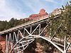 |
1938, 1939 | 1989-03-31 | Sedona Sedona, Arizona Sedona is a city that straddles the county line between Coconino and Yavapai counties in the northern Verde Valley region of the U.S. state of Arizona... 34°53′7"N 111°44′30"W |
Coconino Coconino County, Arizona -2010:Whereas according to the 2010 U.S. Census Bureau:*61.7% White*1.2% Black*27.3% Native American*1.4% Asian*0.1% Native Hawaiian or Pacific Islander*3.1% Two or more races*5.2% Other races*13.5% Hispanic or Latino -2000:... |
Spandrel-braced deck arch |
| Mineral Creek Bridge | 1988-09-30 | Kelvin 33°7′20"N 110°58′32"W |
Pinal Pinal County, Arizona -2010:Whereas according to the 2010 U.S. Census Bureau:*72.4% White*4.6% Black*5.6% Native American*1.7% Asian*0.4% Native Hawaiian or Pacific Islander*3.8% Two or more races*11.5% Other races*28.5% Hispanic or Latino -2000:... |
Concrete Luten arch Luten arch A Luten arch is a patented concrete arch design for bridges, designed by Daniel B. Luten, of Indianapolis. Luten was awarded more than 30 patents for his improvements of the Luten arch design.... |
||
| Mormon Flat Bridge | 1924, 1925 | 1988-09-30 | Tortilla Flat Tortilla Flat, Arizona Tortilla Flat is a small unincorporated community in far eastern Maricopa County, Arizona, United States. It is located in the central part of the state, northeast of Apache Junction. It is the last surviving stagecoach stop along the Apache Trail. According to the Gross Management Department of... 33°32′20"N 111°26′34"W |
Maricopa Maricopa County, Arizona -2010:Whereas according to the 2010 U.S. Census Bureau:*73.0% White*5.0% Black*2.1% Native American*3.5% Asian*0.2% Native Hawaiian or Pacific Islander*3.5% Two or more races*12.7% Other races*29.6% Hispanic or Latino -2000:... |
Camelback through truss | |
| Navajo Bridge Navajo Bridge Navajo Bridge crosses the Colorado River's Marble Canyon near Lee's Ferry in the US state of Arizona. Apart from the Glen Canyon Bridge a few miles upstream at Page, Arizona, it is the only roadway crossing of the river and the Grand Canyon for nearly... |
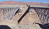 |
1927-1929 | 1981-08-13 | Lee's Ferry 36°49′5"N 111°37′52"W |
Coconino Coconino County, Arizona -2010:Whereas according to the 2010 U.S. Census Bureau:*61.7% White*1.2% Black*27.3% Native American*1.4% Asian*0.1% Native Hawaiian or Pacific Islander*3.1% Two or more races*5.2% Other races*13.5% Hispanic or Latino -2000:... |
Spandrel-braced deck arch |
| Ocean to Ocean Bridge | 1914, 1915 | 1979-09-11 | Yuma Yuma, Arizona Yuma is a city in and the county seat of Yuma County, Arizona, United States. It is located in the southwestern corner of the state, and the population of the city was 77,515 at the 2000 census, with a 2008 Census Bureau estimated population of 90,041.... 32°43′42"N 114°36′53"W |
Yuma Yuma County, Arizona -2010:Whereas according to the 2010 U.S. Census Bureau:*70.4% White*2.0% Black*1.6% Native American*1.2% Asian*0.2% Native Hawaiian or Pacific Islander*3.8% Two or more races*20.8% Other races*59.7% Hispanic or Latino -2000:... |
Through truss | |
| Old Trails Bridge | 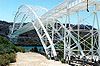 |
1915, 1916 | 1988-09-30 | Topock Topock, Arizona Topock is a small unincorporated community in Mohave County, Arizona. Topock has a ZIP Code of 86436; in 2000, the population of the 86436 ZCTA was 1,790.... 34°42′57"N 114°29′5"W |
Mohave Mohave County, Arizona Mohave County is located in the northwestern corner of the U.S. state of Arizona. As of the 2010 census, its population was 200,186, an increase of 45,154 people since the 2000 census count of 155,032. The county seat is Kingman... |
Brace-ribbed through arch |
| Park Avenue Bridge | 1918 | 1988-09-30 | Clifton Clifton, Arizona Clifton is a town in and the county seat of Greenlee County, Arizona, United States, along the San Francisco River. The population of the town was 3,311 at the 2010 census. It was a site of the Arizona Copper Mine Strike of 1983.... 33°3′22"N 109°17′55"W |
Greenlee Greenlee County, Arizona -2010:Whereas according to the 2010 U.S. Census Bureau:*77.2% White*1.1% Black*2.3% Native American*0.5% Asian*0.1% Native Hawaiian or Pacific Islander*3.8% Two or more races*15.0% Other races*47.9% Hispanic or Latino -2000:... |
Through truss | |
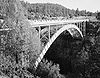
| Perkinsville Bridge Perkinsville Bridge The Perkinsville Bridge over the Verde River was built in 1921. It was listed on the National Register of Historic Places in 1989.It is a Pratt through truss bridge and its significance is under Transportation and Engineering .... |
 |
1921, 1936 | 1989-03-31 | Ash Fork Ash Fork, Arizona Ash Fork is a census-designated place in Yavapai County, Arizona, United States. The population was 457 at the 2000 census.-Geography:Ash Fork is located at .... 34°53′43"N 112°12′18"W |
Yavapai Yavapai County, Arizona -2010:Whereas according to the 2010 U.S. Census Bureau:*89.3% White*0.6% Black*1.7% Native American*0.8% Asian*0.1% Native Hawaiian or Pacific Islander*2.5% Two or more races*5.0% Other races*13.6% Hispanic or Latino -2000:... |
Pratt through truss |
| Petrified Forest Bridge | 1932 | removed 1998-11-27 |
Navajo | Apache Apache County, Arizona -2010:Whereas according to the 2010 U.S. Census Bureau:*23.3% White*0.2% Black*72.9% Native American*0.3% Asian*0.0% Native Hawaiian or Pacific Islander*2.0% Two or more races*1.3% Other races*5.8% Hispanic or Latino -2000:... |
Girder and stringer | |
| Pine Creek Bridge | 1925 | 1988-09-30 | Tortilla Flat Tortilla Flat, Arizona Tortilla Flat is a small unincorporated community in far eastern Maricopa County, Arizona, United States. It is located in the central part of the state, northeast of Apache Junction. It is the last surviving stagecoach stop along the Apache Trail. According to the Gross Management Department of... 33°35′54"N 111°12′8"W |
Maricopa Maricopa County, Arizona -2010:Whereas according to the 2010 U.S. Census Bureau:*73.0% White*5.0% Black*2.1% Native American*3.5% Asian*0.2% Native Hawaiian or Pacific Islander*3.5% Two or more races*12.7% Other races*29.6% Hispanic or Latino -2000:... |
Filled spandrel arch | |
| Poland Tunnel | 1904 | 1978-03-29 | Poland | Yavapai Yavapai County, Arizona -2010:Whereas according to the 2010 U.S. Census Bureau:*89.3% White*0.6% Black*1.7% Native American*0.8% Asian*0.1% Native Hawaiian or Pacific Islander*2.5% Two or more races*5.0% Other races*13.6% Hispanic or Latino -2000:... |
||
| Pumphouse Wash Bridge | 1931 | 1988-09-30 | Flagstaff Flagstaff, Arizona Flagstaff is a city located in northern Arizona, in the southwestern United States. In 2010, the city's population was 65,870. The population of the Metropolitan Statistical Area was at 134,421 in 2010. It is the county seat of Coconino County... 35°1′30"N 111°44′6"W |
Coconino Coconino County, Arizona -2010:Whereas according to the 2010 U.S. Census Bureau:*61.7% White*1.2% Black*27.3% Native American*1.4% Asian*0.1% Native Hawaiian or Pacific Islander*3.1% Two or more races*5.2% Other races*13.5% Hispanic or Latino -2000:... |
Steel stringer | |
| Queen Creek Bridge |  |
1919, 1920 | 1988-09-30 | Florence Junction 33°17′16"N 111°19′42"W |
Pinal Pinal County, Arizona -2010:Whereas according to the 2010 U.S. Census Bureau:*72.4% White*4.6% Black*5.6% Native American*1.7% Asian*0.4% Native Hawaiian or Pacific Islander*3.8% Two or more races*11.5% Other races*28.5% Hispanic or Latino -2000:... |
Concrete Luten arch Luten arch A Luten arch is a patented concrete arch design for bridges, designed by Daniel B. Luten, of Indianapolis. Luten was awarded more than 30 patents for his improvements of the Luten arch design.... |
| Queen Creek Bridge | 1920, 1921 | 1988-09-30 | Superior 33°17′47"N 111°5′19"W |
Pinal Pinal County, Arizona -2010:Whereas according to the 2010 U.S. Census Bureau:*72.4% White*4.6% Black*5.6% Native American*1.7% Asian*0.4% Native Hawaiian or Pacific Islander*3.8% Two or more races*11.5% Other races*28.5% Hispanic or Latino -2000:... |
Open spandrel deck arch | |
| Querino Canyon Bridge | 1930 | 1988-09-30 | Houck Houck, Arizona Houck is a census-designated place in Apache County, Arizona, United States. The population was 1,087 at the 2000 census.-Geography:Houck is located at .... 35°16′49"N 109°15′28"W |
Apache Apache County, Arizona -2010:Whereas according to the 2010 U.S. Census Bureau:*23.3% White*0.2% Black*72.9% Native American*0.3% Asian*0.0% Native Hawaiian or Pacific Islander*2.0% Two or more races*1.3% Other races*5.8% Hispanic or Latino -2000:... |
Warren deck truss | |
| Reppy Avenue Bridge | 1921 | 1988-09-30 | Miami Miami, Arizona Miami is a town in Gila County, Arizona, United States. Miami is a classic Western copper boomtown, though the copper mines are largely dormant now... 33°23′42"N 110°52′34"W |
Gila Gila County, Arizona -2010:Whereas according to the 2010 U.S. Census Bureau:*76.8% White*0.4% Black*14.8% Native American*0.5% Asian*0.1% Native Hawaiian or Pacific Islander*2.0% Two or more races*5.4% Other races*17.9% Hispanic or Latino -2000:... |
Luten arch Luten arch A Luten arch is a patented concrete arch design for bridges, designed by Daniel B. Luten, of Indianapolis. Luten was awarded more than 30 patents for his improvements of the Luten arch design.... |
|
| Sacaton Dam Bridge | 1924, 1925 | 1988-09-30 | Sacaton Sacaton, Arizona Sacaton is a census-designated place in Pinal County, Arizona, United States. The population was 1,584 at the 2000 census... 33°5′19"N 111°41′11"W |
Pinal Pinal County, Arizona -2010:Whereas according to the 2010 U.S. Census Bureau:*72.4% White*4.6% Black*5.6% Native American*1.7% Asian*0.4% Native Hawaiian or Pacific Islander*3.8% Two or more races*11.5% Other races*28.5% Hispanic or Latino -2000:... |
Concrete slab and girder | |
| Salt River Bridge | 1920 | 1988-09-30 | Roosevelt Roosevelt, Arizona Roosevelt is an unincorporated community in Gila County in the U.S. State of Arizona, located on the south shore of Theodore Roosevelt Lake. Roosevelt has a ZIP Code of 85545; in 2000, the population of the 85545 ZCTA was 616.... 33°37′9"N 110°55′15"W |
Gila Gila County, Arizona -2010:Whereas according to the 2010 U.S. Census Bureau:*76.8% White*0.4% Black*14.8% Native American*0.5% Asian*0.1% Native Hawaiian or Pacific Islander*2.0% Two or more races*5.4% Other races*17.9% Hispanic or Latino -2000:... |
Through truss | |
| Salt River Canyon Bridge |  |
1934 | 1988-09-30 | Carrizo 33°47′19"N 110°30′50"W |
Gila Gila County, Arizona -2010:Whereas according to the 2010 U.S. Census Bureau:*76.8% White*0.4% Black*14.8% Native American*0.5% Asian*0.1% Native Hawaiian or Pacific Islander*2.0% Two or more races*5.4% Other races*17.9% Hispanic or Latino -2000:... |
Arch Arch bridge An arch bridge is a bridge with abutments at each end shaped as a curved arch. Arch bridges work by transferring the weight of the bridge and its loads partially into a horizontal thrust restrained by the abutments at either side... |
| San Tan Canal Bridge | 1925, 1926 | 1988-09-30 | Sacaton Sacaton, Arizona Sacaton is a census-designated place in Pinal County, Arizona, United States. The population was 1,584 at the 2000 census... 33°5′30"N 111°41′11"W |
Pinal Pinal County, Arizona -2010:Whereas according to the 2010 U.S. Census Bureau:*72.4% White*4.6% Black*5.6% Native American*1.7% Asian*0.4% Native Hawaiian or Pacific Islander*3.8% Two or more races*11.5% Other races*28.5% Hispanic or Latino -2000:... |
Skewed concrete girder | |
| Sand Hollow Wash Bridge | 1929, 1930 | 1988-09-30 | Littlefield Littlefield, Arizona Littlefield is an unincorporated community in Mohave County located in the Arizona Strip region of the U.S. state of Arizona. It is located along Interstate 15 approximately 10 miles northeast of Mesquite, Nevada... 36°49′40"N 113°59′59"W |
Mohave Mohave County, Arizona Mohave County is located in the northwestern corner of the U.S. state of Arizona. As of the 2010 census, its population was 200,186, an increase of 45,154 people since the 2000 census count of 155,032. The county seat is Kingman... |
Warren deck truss | |
| Sanders Bridge | 1923 | 1988-09-30 | Sanders Sanders, Arizona Sanders is an unincorporated community in Apache County, Arizona, United States. Sanders is located at the junction of US 191 and Interstate 40, within the Navajo Nation.... 35°12′46"N 109°19′47"W |
Apache Apache County, Arizona -2010:Whereas according to the 2010 U.S. Census Bureau:*23.3% White*0.2% Black*72.9% Native American*0.3% Asian*0.0% Native Hawaiian or Pacific Islander*2.0% Two or more races*1.3% Other races*5.8% Hispanic or Latino -2000:... |
Pratt pony truss | |
| Santa Cruz Bridge No. 1 | 1917 | 1988-09-30 | Nogales Nogales, Arizona Nogales is a city in Santa Cruz County, Arizona, United States. The population was 21,017 at the 2010 census. According to 2005 Census Bureau estimates, the population of the city is 20,833. The city is the county seat of Santa Cruz County.... 31°23′19"N 110°52′25"W |
Santa Cruz Santa Cruz County, Arizona -2010:Whereas according to the 2010 U.S. Census Bureau:*73.5% White*0.4% Black*0.7% Native American*0.5% Asian*0.0% Native Hawaiian or Pacific Islander*2.0% Two or more races*22.9% Other races*82.8% Hispanic or Latino -2000:... |
Concrete girder | |
| Sixth Avenue Underpass | 1930 | 1988-09-30 | Tucson Tucson, Arizona Tucson is a city in and the county seat of Pima County, Arizona, United States. The city is located 118 miles southeast of Phoenix and 60 miles north of the U.S.-Mexico border. The 2010 United States Census puts the city's population at 520,116 with a metropolitan area population at 1,020,200... 32°13′30"N 110°58′5"W |
Pima Pima County, Arizona -2010:Whereas according to the 2010 U.S. Census Bureau:*74.3% White*3.5% Black*3.3% Native American*2.6% Asian*0.2% Native Hawaiian or Pacific Islander*3.7% Two or more races*12.4% Other races*34.6% Hispanic or Latino -2000:... |
Concrete slab | |
| Solomonville Road Overpass | 1907 | 1988-09-30 | Clifton Clifton, Arizona Clifton is a town in and the county seat of Greenlee County, Arizona, United States, along the San Francisco River. The population of the town was 3,311 at the 2010 census. It was a site of the Arizona Copper Mine Strike of 1983.... , Safford Safford, Arizona - History :Safford was founded by Joshua Eaton Bailey, Hiram Kennedy and Edward Tuttle, who came from Gila Bend, in southwestern Arizona. They left Gila Bend in the winter of 1873-74; their work on canals and dams having been destroyed by high water the previous summer... 32°59′41"N 109°17′17"W |
Greenlee Greenlee County, Arizona -2010:Whereas according to the 2010 U.S. Census Bureau:*77.2% White*1.1% Black*2.3% Native American*0.5% Asian*0.1% Native Hawaiian or Pacific Islander*3.8% Two or more races*15.0% Other races*47.9% Hispanic or Latino -2000:... |
Filled spandrel arch | |
| St. Joseph Bridge | 1917 | 1988-09-30 | Joseph City Joseph City, Arizona Joseph City is an unincorporated community located in Navajo County, Arizona, United States. It is located on Interstate 40 about eighty miles east of Flagstaff.... 34°56′28"N 110°19′23"W |
Navajo Navajo County, Arizona -2010:Whereas according to the 2010 U.S. Census Bureau:*49.3% White*0.9% Black*43.4% Native American*0.5% Asian*0.1% Native Hawaiian or Pacific Islander*2.5% Two or more races*3.3% Other races*10.8% Hispanic or Latino -2000:... |
Pony truss | |
| Stone Avenue Underpass | 1936 | 1988-09-30 | Tucson Tucson, Arizona Tucson is a city in and the county seat of Pima County, Arizona, United States. The city is located 118 miles southeast of Phoenix and 60 miles north of the U.S.-Mexico border. The 2010 United States Census puts the city's population at 520,116 with a metropolitan area population at 1,020,200... 32°13′37"N 110°58′16"W |
Pima Pima County, Arizona -2010:Whereas according to the 2010 U.S. Census Bureau:*74.3% White*3.5% Black*3.3% Native American*2.6% Asian*0.2% Native Hawaiian or Pacific Islander*3.7% Two or more races*12.4% Other races*34.6% Hispanic or Latino -2000:... |
Concrete slab | |
| Tempe Bridge | 1911–1913 | removed 1992-10-02 |
Tempe Tempe, Arizona Tempe is a city in Maricopa County, Arizona, USA, with the Census Bureau reporting a 2010 population of 161,719. The city is named after the Vale of Tempe in Greece. Tempe is located in the East Valley section of metropolitan Phoenix; it is bordered by Phoenix and Guadalupe on the west, Scottsdale... |
Maricopa Maricopa County, Arizona -2010:Whereas according to the 2010 U.S. Census Bureau:*73.0% White*5.0% Black*2.1% Native American*3.5% Asian*0.2% Native Hawaiian or Pacific Islander*3.5% Two or more races*12.7% Other races*29.6% Hispanic or Latino -2000:... |
Open spandrel deck arch | |
| Tempe Concrete Arch Highway Bridge | 1911 | 1984-05-07 | Tempe Tempe, Arizona Tempe is a city in Maricopa County, Arizona, USA, with the Census Bureau reporting a 2010 population of 161,719. The city is named after the Vale of Tempe in Greece. Tempe is located in the East Valley section of metropolitan Phoenix; it is bordered by Phoenix and Guadalupe on the west, Scottsdale... 33°25′52"N 111°56′30"W |
Maricopa Maricopa County, Arizona -2010:Whereas according to the 2010 U.S. Census Bureau:*73.0% White*5.0% Black*2.1% Native American*3.5% Asian*0.2% Native Hawaiian or Pacific Islander*3.5% Two or more races*12.7% Other races*29.6% Hispanic or Latino -2000:... |
||
| Verde River Bridge Verde River Bridge The Verde River Bridge near Paulden, Arizona was built in 1922. It was listed on the National Register of Historic Places in 1988.It is a filled spandrel arch bridge with a 100 foot span.It is located on Sullivan Lake Rd., what is now labelled on maps as N... |
1922, 1923 | 1988-09-30 | Paulden Paulden, Arizona Paulden is a census-designated place in Yavapai County, Arizona, United States. The population was 3,420 at the 2000 census.-Geography:Paulden is located at .... 34°51′50"N 112°27′34"W |
Yavapai Yavapai County, Arizona -2010:Whereas according to the 2010 U.S. Census Bureau:*89.3% White*0.6% Black*1.7% Native American*0.8% Asian*0.1% Native Hawaiian or Pacific Islander*2.5% Two or more races*5.0% Other races*13.6% Hispanic or Latino -2000:... |
Filled spandrel arch | |
| Verde River Sheep Bridge | 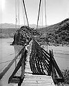 |
1940, 1944 | 1978-11-21 | Carefree Carefree, Arizona Carefree is a town in Maricopa County, Arizona, United States. According to 2006 Census Bureau estimates, the population of the town is 3,799.-History:... 34°4′39"N 111°42′26"W |
Yavapai Yavapai County, Arizona -2010:Whereas according to the 2010 U.S. Census Bureau:*89.3% White*0.6% Black*1.7% Native American*0.8% Asian*0.1% Native Hawaiian or Pacific Islander*2.5% Two or more races*5.0% Other races*13.6% Hispanic or Latino -2000:... |
Suspension Suspension bridge A suspension bridge is a type of bridge in which the deck is hung below suspension cables on vertical suspenders. Outside Tibet and Bhutan, where the first examples of this type of bridge were built in the 15th century, this type of bridge dates from the early 19th century... |
| Walnut Canyon Bridge | 1923, 1924 | 1988-09-30 | Winona Winona, Arizona Winona is a small unincorporated community in Coconino County in the northern part of the U.S. state of Arizona.It is located along U.S. Route 66 and was made famous in the song " Route 66"... 35°12′42"N 111°25′14"W |
Coconino Coconino County, Arizona -2010:Whereas according to the 2010 U.S. Census Bureau:*61.7% White*1.2% Black*27.3% Native American*1.4% Asian*0.1% Native Hawaiian or Pacific Islander*3.1% Two or more races*5.2% Other races*13.5% Hispanic or Latino -2000:... |
Parker through truss | |
| Walnut Creek Bridge | 1921, 1936 | 1989-03-31 | Simmons 34°55′44"N 112°48′55"W |
Yavapai Yavapai County, Arizona -2010:Whereas according to the 2010 U.S. Census Bureau:*89.3% White*0.6% Black*1.7% Native American*0.8% Asian*0.1% Native Hawaiian or Pacific Islander*2.5% Two or more races*5.0% Other races*13.6% Hispanic or Latino -2000:... |
Pratt through truss | |
| Walnut Grove Bridge | 1924 | 1988-09-30 | Walnut Grove 34°18′37"N 112°34′5"W |
Yavapai Yavapai County, Arizona -2010:Whereas according to the 2010 U.S. Census Bureau:*89.3% White*0.6% Black*1.7% Native American*0.8% Asian*0.1% Native Hawaiian or Pacific Islander*2.5% Two or more races*5.0% Other races*13.6% Hispanic or Latino -2000:... |
Through and pony truss | |
| Winkelman Bridge | 1916 | 1988-09-30 | Winkelman Winkelman, Arizona Winkelman is a town in Gila and Pinal counties in the U.S. state of Arizona. According to 2006 Census Bureau estimates, the population of the town was 444, almost all of whom lived in Gila County.-Geography:... 32°59′6"N 110°46′18"W |
Pinal Pinal County, Arizona -2010:Whereas according to the 2010 U.S. Census Bureau:*72.4% White*4.6% Black*5.6% Native American*1.7% Asian*0.4% Native Hawaiian or Pacific Islander*3.8% Two or more races*11.5% Other races*28.5% Hispanic or Latino -2000:... |
Concrete Luten arch Luten arch A Luten arch is a patented concrete arch design for bridges, designed by Daniel B. Luten, of Indianapolis. Luten was awarded more than 30 patents for his improvements of the Luten arch design.... |
|
| Winslow Bridge | 1939 | 1989-03-31 | Winslow Winslow, Arizona -Demographics:As of the census of 2000, there were 9,520 people, 2,754 households, and 1,991 families residing in the city. The population density was 773.1 people per square mile . There were 3,198 housing units at an average density of 259.7 per square mile... 35°0′24"N 110°39′18"W |
Navajo Navajo County, Arizona -2010:Whereas according to the 2010 U.S. Census Bureau:*49.3% White*0.9% Black*43.4% Native American*0.5% Asian*0.1% Native Hawaiian or Pacific Islander*2.5% Two or more races*3.3% Other races*10.8% Hispanic or Latino -2000:... |
Girder and stringer | |
| Winslow Underpass | 1936 | 1988-09-30 | Winslow Winslow, Arizona -Demographics:As of the census of 2000, there were 9,520 people, 2,754 households, and 1,991 families residing in the city. The population density was 773.1 people per square mile . There were 3,198 housing units at an average density of 259.7 per square mile... 35°1′17"N 110°39′17"W |
Navajo Navajo County, Arizona -2010:Whereas according to the 2010 U.S. Census Bureau:*49.3% White*0.9% Black*43.4% Native American*0.5% Asian*0.1% Native Hawaiian or Pacific Islander*2.5% Two or more races*3.3% Other races*10.8% Hispanic or Latino -2000:... |
Concrete slab | |
| Woodruff Bridge | 1917 | 1988-09-30 | Woodruff Woodruff, Arizona Woodruff is an unincorporated community in Navajo County, Arizona, United States. Woodruff is southeast of Holbrook. Woodruff has a post office with ZIP code 85942.... 34°44′22"N 110°2′12"W |
Navajo Navajo County, Arizona -2010:Whereas according to the 2010 U.S. Census Bureau:*49.3% White*0.9% Black*43.4% Native American*0.5% Asian*0.1% Native Hawaiian or Pacific Islander*2.5% Two or more races*3.3% Other races*10.8% Hispanic or Latino -2000:... |
Warren through truss |