

Sanders, Arizona
Encyclopedia
Unincorporated area
In law, an unincorporated area is a region of land that is not a part of any municipality.To "incorporate" in this context means to form a municipal corporation, a city, town, or village with its own government. An unincorporated community is usually not subject to or taxed by a municipal government...
in Apache County
Apache County, Arizona
-2010:Whereas according to the 2010 U.S. Census Bureau:*23.3% White*0.2% Black*72.9% Native American*0.3% Asian*0.0% Native Hawaiian or Pacific Islander*2.0% Two or more races*1.3% Other races*5.8% Hispanic or Latino -2000:...
, Arizona
Arizona
Arizona ; is a state located in the southwestern region of the United States. It is also part of the western United States and the mountain west. The capital and largest city is Phoenix...
, United States
United States
The United States of America is a federal constitutional republic comprising fifty states and a federal district...
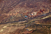
. Sanders is located at the junction of US 191 and Interstate 40
Interstate 40
Interstate 40 is the third-longest major east–west Interstate Highway in the United States, after I-90 and I-80. Its western end is at Interstate 15 in Barstow, California; its eastern end is at a concurrency of U.S. Route 117 and North Carolina Highway 132 in Wilmington, North Carolina...
, within the Navajo Nation
Navajo Nation
The Navajo Nation is a semi-autonomous Native American-governed territory covering , occupying all of northeastern Arizona, the southeastern portion of Utah, and northwestern New Mexico...
.
Sanders has the Zip code
ZIP Code
ZIP codes are a system of postal codes used by the United States Postal Service since 1963. The term ZIP, an acronym for Zone Improvement Plan, is properly written in capital letters and was chosen to suggest that the mail travels more efficiently, and therefore more quickly, when senders use the...
86512. The 86512 ZIP Code Tabulation Area
ZIP Code Tabulation Area
ZIP Code Tabulation Areas are statistical entities developed by the United States Census Bureau for tabulating summary statistics from Census 2000. This new entity was developed to overcome the difficulties in precisely defining the land area covered by each ZIP code...
had a population of 2,245 at the 2000 census. The Sanders ZCTA population was 90% American Indian, and 30% of Sanders ZCTA households had income of less than $10,000, at the 2000 census.
Sanders is located at Exit 339 on Interstate 140.