

List of bridges in Ottawa
Encyclopedia
This is a list of bridges in the city of Ottawa
, Ontario
, Canada
. They are listed from west to east for the Ottawa River or North to South for the Rideau River and Canal.
 Bridges spanning the Ottawa River
from west to east:
 Bridges spanning the Rideau River
from north to south:
Spanning the Rideau Canal
 Bridges spanning the Rideau Canal
from north to south:
Bridges carrying roads or pedestrian ways over or under Higways 417, Highway 416 and Ottawa Highway 174 ar not listed.
Ottawa
Ottawa is the capital of Canada, the second largest city in the Province of Ontario, and the fourth largest city in the country. The city is located on the south bank of the Ottawa River in the eastern portion of Southern Ontario...
, Ontario
Ontario
Ontario is a province of Canada, located in east-central Canada. It is Canada's most populous province and second largest in total area. It is home to the nation's most populous city, Toronto, and the nation's capital, Ottawa....
, Canada
Canada
Canada is a North American country consisting of ten provinces and three territories. Located in the northern part of the continent, it extends from the Atlantic Ocean in the east to the Pacific Ocean in the west, and northward into the Arctic Ocean...
. They are listed from west to east for the Ottawa River or North to South for the Rideau River and Canal.
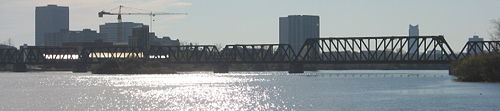
Spanning the Ottawa River
Ottawa River
The Ottawa River is a river in the Canadian provinces of Ontario and Quebec. For most of its length, it now defines the border between these two provinces.-Geography:...
from west to east:
- OCRROttawa Central RailwayThe Ottawa Central Railway is a Canadian shortline railway subsidiary of the Canadian National Railway. The headquarters are at the Walkley Yard, 3141 Albion Road South, Ottawa, Ontario, Canada....
railway bridge- Connects Vydon Acres to Pontiac-Station, Quebec near Chats FallsChats FallsChats Falls were a set of waterfalls on the Ottawa River, near Fitzroy Harbour, Ontario, and Quyon, Quebec, Canada. A hydroelectric generating station is now located here, owned and operated jointly by Hydro-Québec and Ontario Power Generation...
.
- Connects Vydon Acres to Pontiac-Station, Quebec near Chats Falls
- Champlain BridgeChamplain Bridge (Ottawa)The Champlain Bridge crosses the Ottawa River about west of Parliament Hill, joining the communities of Ottawa, Ontario and Gatineau, Quebec. It is the westernmost link between the two cities....
- Connects Island Park DriveIsland Park DriveIsland Park Drive is a short, but important and scenic, north-south street in Ottawa, Ontario, Canada. It is one of several parkways in Ottawa administered by the National Capital Commission providing scenic routes throughout Canada's capital region....
in Westboro to Place Samuel-de-Champlain in the Aylmer sectorAylmer, QuebecAylmer is a former city in Quebec, Canada. It became a sector of the City of Gatineau on January 1, 2002. Located on the Ottawa River and Route 148 it is a part of the National Capital Region. The population in 2006 was 41 882 — approx. 16% of Gatineau...
of GatineauGatineauGatineau is a city in western Quebec, Canada. It is the fourth largest city in the province. It is located on the northern banks of the Ottawa River, immediately across from Ottawa, Ontario, and together they form Canada's National Capital Region. Ottawa and Gatineau comprise a single Census...
, QuebecQuebecQuebec or is a province in east-central Canada. It is the only Canadian province with a predominantly French-speaking population and the only one whose sole official language is French at the provincial level....
. Owned by the National Capital CommissionNational Capital CommissionThe National Capital Commission , is a Canadian Crown corporation that administers the federally owned lands and buildings in Canada's National Capital Region, including Ottawa, Ontario and Gatineau, Quebec.The NCC was created in 1959, replacing the Federal District Commission , which had been...
.
- Connects Island Park Drive
- Prince of Wales BridgePrince of Wales BridgeThe Prince of Wales Bridge is a rail bridge across the Ottawa River joining Ottawa, Ontario to Gatineau, Quebec. It connected with the Canadian Pacific Railway line just west of Lebreton Flats, and crosses the south channel of the river to Lemieux Island; it then continues across the northern...
- Railway bridge connecting MechanicsvilleMechanicsville (Ottawa)Mechanicsville is a neighbourhood of Ottawa, Ontario, Canada. It is located to the west of downtown and bordered by the Ottawa River to the north, the transitway railway to the east, Scott Street to the south, and Parkdale Avenue to the west...
to the Hull sectorHull, QuebecHull is the central and oldest part of the city of Gatineau, Quebec, Canada. It is located on the west bank of the Gatineau River and the north shore of the Ottawa River, directly opposite Ottawa. As part of the Canadian National Capital Region, it contains offices for twenty thousand...
of GatineauGatineauGatineau is a city in western Quebec, Canada. It is the fourth largest city in the province. It is located on the northern banks of the Ottawa River, immediately across from Ottawa, Ontario, and together they form Canada's National Capital Region. Ottawa and Gatineau comprise a single Census...
, QuebecQuebecQuebec or is a province in east-central Canada. It is the only Canadian province with a predominantly French-speaking population and the only one whose sole official language is French at the provincial level....
via Lemieux IslandLemieux IslandLemieux Island, , is a small island in the middle of the Ottawa River, between Gatineau, Quebec, and Ottawa, Ontario. It is part of the city of Ottawa. The Prince of Wales Bridge goes over it, and a water filtration plant was built on the island....
- Railway bridge connecting Mechanicsville
- Chaudière Bridge
- Connects Booth Street in Lebreton FlatsLebreton FlatsLeBreton Flats is a neighbourhood in Ottawa, Canada. It lies to the west of Centretown neighbourhood, and to the north of Centretown West with "Nanny Goat Hill" as the dividing line...
to Rue Eddy in Hull; Ottawa's oldest bridge.
- Connects Booth Street in Lebreton Flats
- Portage BridgePortage BridgeThe Portage Bridge crosses the Ottawa River just down-river from the Chaudière Bridge, joining the communities of Gatineau, Quebec and Ottawa, Ontario, linking Laurier Street and Alexandre-Taché Boulevard in the Hull sector of Gatineau and Wellington Street at the Garden of the Provinces and...
- Connects Wellington StreetWellington Street (Ottawa)Wellington Street is an important street in Ottawa, Canada most notable for being one of the first two streets laid out in Bytown in 1826 Wellington Street (French: Rue Wellington) is an important street in Ottawa, Canada most notable for being one of the first two streets laid out in Bytown in...
in Lebreton FlatsLebreton FlatsLeBreton Flats is a neighbourhood in Ottawa, Canada. It lies to the west of Centretown neighbourhood, and to the north of Centretown West with "Nanny Goat Hill" as the dividing line...
to Boulevard MaisonneuveBoulevard MaisonneuveBoulevard Maisonneuve is an important arterial in the heart of Downtown Gatineau, Quebec. It serves as connector route between the Portage Bridge from Ottawa to Quebec Autoroutes 5 and 50 as well as Boulevard Fournier towards the Gatineau sector of the city, northern portions of the Hull sector and...
in Hull.
- Connects Wellington Street
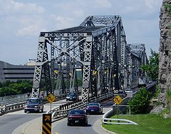
- Interprovincial (Alexandra) BridgeAlexandra BridgeThe Royal Alexandra Interprovincial Bridge is a steel truss cantilever bridge spanning the Ottawa River between Ottawa, Ontario and Gatineau, Quebec. It is known locally as both the "Alexandra Bridge" and the "Interprovincial Bridge".-History:...
- Connects St. Patrick Street and Murray Street in Lower TownLower TownLowertown is a district in the central area of Ottawa, Ontario, Canada to the east of downtown. It is bounded roughly by Rideau Street to the south, Sussex Drive and Ottawa River to the north, the Rideau Canal to the west, and the Rideau River to the east...
to Boulevard des Allumettières in Hull.
- Connects St. Patrick Street and Murray Street in Lower Town
- Macdonald-Cartier BridgeMacdonald-Cartier BridgeThe Macdonald-Cartier Bridge is a bridge connecting Ottawa, Ontario, to Gatineau, Quebec. The bridge is a 618 m long continuous steel box girder bridge and carries six lanes of traffic. It links King Edward Avenue and Sussex Drive in Ottawa with Autoroute 5 in Quebec...
- Connects King Edward AvenueKing Edward Avenue (Ottawa)King Edward Avenue is a major thoroughfare in the eastern part of Ottawa, Ontario, Canada.King Edward Avenue runs from the Macdonald-Cartier Bridge southward to the Queensway. The street was originally named "King Street" and was renamed to honour King Edward VII...
in Lower Town to Autoroute de la Gatineau (Autoroute 5Quebec Autoroute 5Autoroute 5 is a short Autoroute in the Outaouais region of western Quebec. It connects the central urban area of Gatineau with the recreational areas of Gatineau Park and the exurban rural areas of Chelsea and La Pêche...
) in Hull.
- Connects King Edward Avenue
Spanning the Rideau River
Rideau River
thumb|Rapids on the Rideau River opposite [[Carleton University]].The Rideau River is a Southern Ontario river which flows north from Upper Rideau Lake and empties into the Ottawa River at Rideau Falls in Ottawa, Ontario. Its length is 146 km...
from north to south:
- Sussex Drive
- Connects Lower TownLower TownLowertown is a district in the central area of Ottawa, Ontario, Canada to the east of downtown. It is bounded roughly by Rideau Street to the south, Sussex Drive and Ottawa River to the north, the Rideau Canal to the west, and the Rideau River to the east...
and New EdinburghNew EdinburghNew Edinburgh is a small neighbourhood in Ottawa, Canada. It is located to the east of the downtown core. It is bordered on the west by the Rideau River, to the north by the Ottawa River, to the south by Beechwood Avenue, to the east the border is less regular but is marked in part by Springfield...
via Sussex Drive
- Connects Lower Town
- Minto Bridges
- Connects King Edward Avenue in Lower TownLower TownLowertown is a district in the central area of Ottawa, Ontario, Canada to the east of downtown. It is bounded roughly by Rideau Street to the south, Sussex Drive and Ottawa River to the north, the Rideau Canal to the west, and the Rideau River to the east...
to Union Street in New EdinburghNew EdinburghNew Edinburgh is a small neighbourhood in Ottawa, Canada. It is located to the east of the downtown core. It is bordered on the west by the Rideau River, to the north by the Ottawa River, to the south by Beechwood Avenue, to the east the border is less regular but is marked in part by Springfield...
- Connects King Edward Avenue in Lower Town
- St. Patrick Bridge
- Connects St. Patrick Street in Lower Town to Beechwood AvenueBeechwood Avenue (Ottawa)Beechwood Avenue is a major east-west road in Ottawa, Canada. It is the main street of the New Edinburgh neighbourhood and also of northern Vanier. The road begins at the Rideau River, a continuation of Lower Town's St. Patrick Street which continues until the Alexandra Bridge towards Gatineau...
in VanierVanier, Ontario-External links:**...
.
- Connects St. Patrick Street in Lower Town to Beechwood Avenue
- Cummings BridgeCummings BridgeThe Cummings Bridge in Ottawa, constructed in 1921, connects Rideau Street to Montreal Road in Vanier.-History:The area east of the Cummings Bridge, later named Vanier was first linked to the Sandy Hill area of Ottawa with a wooden bridge erected in 1835, which went over a small island in the...
- Connects Rideau StreetRideau StreetRideau Street is a major street in downtown Ottawa, Ontario, Canada and one of Ottawa's oldest and most famous streets running from Wellington Street in the west to Montreal Road in the east where it connects to the Vanier district...
in Sandy HillSandy HillSandy Hill is a bilingual neighbourhood in Ottawa, Ontario located just east of downtown. The neighbourhood is bordered on the west by the Rideau Canal and on the east by the Rideau River. To the north it stretches to Rideau Street and the Byward Market area while to the south it is bordered by...
to Montreal Road in VanierVanier, Ontario-External links:**...
.
- Connects Rideau Street
- Hurdman Bridge
- Connects Sandy HillSandy HillSandy Hill is a bilingual neighbourhood in Ottawa, Ontario located just east of downtown. The neighbourhood is bordered on the west by the Rideau Canal and on the east by the Rideau River. To the north it stretches to Rideau Street and the Byward Market area while to the south it is bordered by...
and Eastway Gardens via the QueenswayQueensway (Ottawa)The Queensway is a major controlled-access freeway running through Ottawa, Ontario, Canada, from Kanata in the west to Orleans in the east. It is the primary east-west transportation artery in the Ottawa-Gatineau area....
, Highway 417Highway 417 (Ontario)King's Highway 417, also known as Highway 417 and the Queensway through Ottawa is a 400-series highways in the Canadian province of Ontario which connects Montreal with Ottawa. It is the backbone of the transportation system in the Ottawa region, where it forms part of the Queensway along with...
.
- Connects Sandy Hill
- Pedestrian bridge
- Connects the University of OttawaUniversity of OttawaThe University of Ottawa is a bilingual, research-intensive, non-denominational, international university in Ottawa, Ontario. It is one of the oldest universities in Canada. It was originally established as the College of Bytown in 1848 by the Missionary Oblates of Mary Immaculate...
's Lees Avenue campus (formerly Algonquin CollegeAlgonquin CollegeAlgonquin College of Applied Arts and Technology is a publicly funded English-language college and member of Polytechnics Canada located in Ottawa, Ontario, Canada. The college serves the National Capital Region and the outlying areas of Eastern Ontario and Western Quebec...
's Rideau Campus) in Ottawa East to Hurdman Park.
- Connects the University of Ottawa
- Transitway
- Connects the Lees Transitway Station and Hurdman Transitway Station.
- George McIlraith Bridge
- Connects Main StreetMain Street (Ottawa)Main Street is a major road in Ottawa, Ontario, Canada. Despite the name, the street isn't Ottawa's "main street", as one would argue that that title would be held by Bank Street. Main Street however is the "main street" for the community of Ottawa East. It was originally the main street of...
in Old Ottawa SouthOld Ottawa SouthOld Ottawa South is an older urban neighbourhood in Ottawa, Canada. As of the Canada 2006 Census, 8,168 people lived in Old Ottawa South, a relatively small and compact neighbourhood, located between the Rideau Canal and the Rideau River . The eastern boundary is defined by Riverdale Avenue and...
to Smyth Road in Alta Vista.
- Connects Main Street
- Billings BridgeBillings BridgeBillings Bridge is a bridge over the Rideau River in Ottawa. Bank Street passes over the river by way of this bridge. The bridge was named after Braddish Billings, who settled in this area and established a farm nearby in 1812. The first bridge, originally called Farmers Bridge, was built over the...
- Connects Old Ottawa South and Alta Vista via Bank StreetBank Street (Ottawa)Bank Street is the major north-south road in Ottawa, Ontario, Canada. It runs south from Wellington Street in downtown Ottawa, south through the neighbourhoods of Centretown, The Glebe, Old Ottawa South, Alta Vista, Hunt Club, and then through the villages of Blossom Park, Leitrim, South...
.
- Connects Old Ottawa South and Alta Vista via Bank Street
- G. Dunbar Bridge
- Connects Carleton UniversityCarleton UniversityCarleton University is a comprehensive university located in the capital of Canada, Ottawa, Ontario. The enabling legislation is The Carleton University Act, 1952, S.O. 1952. Founded as a small college in 1942, Carleton now offers over 65 programs in a diverse range of disciplines. Carleton has...
and Riverside ParkRiverside Park, OttawaRiverside Park is a neighbourhood in the south end of Ottawa, Canada.It is bounded on the north by Brookfield Road, on the east by the Airport Parkway, on the south by Walkley Road and on the west by the Rideau River....
via Bronson AvenueBronson Avenue (Ottawa)Bronson Avenue is a major north-south arterial road in Ottawa, Ontario, Canada. It runs from downtown at Sparks Street in the north through Centretown, past the Glebe and Carleton University and turns into the Airport Parkway, which is an expressway to the Macdonald-Cartier International...
.
- Connects Carleton University
- O-TrainOttawa O-TrainThe O-Train is a light-rail transit service in Ottawa, Ontario, Canada operated by OC Transpo. The present line runs north-south on a railway line, from Bayview to Greenboro, a distance of approximately...
bridge- Connects Carleton and Confederation stops
- Heron Road BridgeHeron Road BridgeThe Heron Road Bridge is a bridge in Ottawa Canada. It connects Baseline Road and Heron Road passing over both the Rideau River and the Rideau Canal just south of Carleton University. The bridge was built in 1966, and its construction saw one of the worst accidents in Ottawa history...
- Connects Baseline RoadBaseline Road (Ottawa)Baseline Road is a road in Ottawa, Ontario, Canada.Baseline runs from Richmond Road east in a straight line until it ends at the Heron Road Bridge over the Rideau River and Rideau Canal when it becomes Heron Road. Before the 2001 City of Ottawa amalgamation, Baseline formed the border of the city...
in Courtland ParkCourtland ParkCourtland Park is a neighbourhood located in southwest Ottawa, Canada. It is bounded on the north by Baseline Road, on the east by the Rideau River, on the south by Dynes Road and on the west by Fisher Avenue.-Features:...
to Heron RoadHeron Road (Ottawa)Heron Road is a major road in Ottawa, Ontario, Canada. It runs from Walkley Road at an angle to the Rideau River, where it turns into Baseline Road. Heron is home to the Public Works and Government Services Canada headquarters, as well as the Canada Post headquarters and the Edward Drake Building...
in Alta Vista. Also crosses the Rideau CanalRideau CanalThe Rideau Canal , also known as the Rideau Waterway, connects the city of Ottawa, Ontario, Canada on the Ottawa River to the city of Kingston, Ontario on Lake Ontario. The canal was opened in 1832 as a precaution in case of war with the United States and is still in use today, with most of its...
.
- Connects Baseline Road
- Hog's Back RoadHog's Back RoadHog's Back Road is a road in Ottawa, Ontario, Canada. The road connects Meadowlands Drive and Prince of Wales Drive, to Riverside Drive and Brookfield Road. Colonel By Drive also ends in the middle of Hog's Back Road, between the Rideau Canal and the Rideau River. The road is used as the boundary...
- Connects Rideau ViewRideau ViewRideau View is a neighbourhood of the City of Ottawa, Ontario, Canada, located along the Rideau River. It is part of Ward 16, River. It is bordered by Meadowlands Drive to the south, Claymore Street to the west and Dynes Road to the north. Debra Avenue is the main road that runs through the...
and Riverside Park via Hog's Back Road. Owned by the National Capital Commission. Also crosses over the Rideau Canal.
- Connects Rideau View
- Canadian Northern Ontario Railway Federal Bridge
- Connects the MerivaleMerivaleMerivale is a suburb of Christchurch, New Zealand, north of the city centre. Its boundaries are defined by Statistics New Zealand as being Heaton Street to the north, Papanui Road to the east, Harper and Bealey Avenues to the south and Rossall Sreet to the west, although Real Estate advertising...
area to the Mooney's Bay neighbourhood.
- Connects the Merivale
- Michael J. E. Sheflin Bridge
- Connects Clearview to Airport-Uplands via Hunt Club Road.Hunt Club Road (Ottawa)Hunt Club Road also known as Ottawa Road #32, is a major east-west route in Ottawa, Ontario, Canada. Hunt Club originally ran from Albion Road to Riverside Drive, but was extended east to Hawthorne Road in the late 1980s. The section between Bank Street and Riverside Drive, originally only one lane...
- Connects Clearview to Airport-Uplands via Hunt Club Road.
- Strandherd-Armstrong Bridge (under construction)
- Planned completion date for 2012 and will connect Barrhaven and Riverside South via Strandherd Drive and Earl Armstrong Road.
- Nicolls Island Road
- Connects Nicolls Island to the mainland in GloucesterGloucester, OntarioGloucester is a suburb of and within the City of Ottawa. Gloucester Township was established in 1792 and originally included lands east of the Rideau River from the Ottawa River south to Manotick. It was incorporated as a township in 1850 and became a city in 1981...
.
- Connects Nicolls Island to the mainland in Gloucester
- Bridge Street
- Connects Bridge Street in ManotickManotick, OntarioManotick, Ontario is an exurb in Eastern Ontario on the Rideau River, located on the south edge of Ottawa's urban area. Manotick is located immediately south of the booming suburbs Barrhaven and Riverside South and is about from downtown Ottawa. It has been part of the City of Ottawa since...
to Mitch Owens RoadMitch Owens RoadMitch Owens Road runs along the border primarily of the former city of Gloucester and Osgoode Township. It was named after former Gloucester mayor Mitch Owens....
in OsgoodeOsgoode, OntarioOsgoode is a large village within the city of Ottawa, Canada, located just south of the city proper, near the Rideau River.It was originally part of Osgoode Township but it became part of Ottawa in 2001...
.
- Connects Bridge Street in Manotick
- Regional Road 6
- Connects Roger Stevens Drive in KarsKars, OntarioKars is a small village on the Rideau River within the rural section of the city of Ottawa, Ontario. Prior to amalgamation in 2000 it was part of Rideau Township....
to Snake Island Road in Osgoode.
- Connects Roger Stevens Drive in Kars
- Highway 416Highway 416 (Ontario)King's Highway 416, commonly referred to as Highway 416 and as the Veterans Memorial Highway, is a 400-series highway in the Canadian province of Ontario which connects Highway 417 in Ottawa with Highway 401 between Brockville and Cornwall...
- Connects Reevecraig to Sabourins Crossing
West Branch of the Rideau River
- Barnsdale Road
- Connects NepeanNepean, Ontario- Recent quantity of snow :- History :Nepean Township, originally known as Township D, was established in 1792 and originally included what is now the central area of Ottawa west of the Rideau River. Jehiel Collins, from Vermont, is believed to have been the first person to settle in Nepean...
to Manotick
- Connects Nepean
- Bridge Street
- Connects downtown Manotick to Long Island.
Spanning the Rideau CanalRideau CanalThe Rideau Canal , also known as the Rideau Waterway, connects the city of Ottawa, Ontario, Canada on the Ottawa River to the city of Kingston, Ontario on Lake Ontario. The canal was opened in 1832 as a precaution in case of war with the United States and is still in use today, with most of its...
Rideau Canal
The Rideau Canal , also known as the Rideau Waterway, connects the city of Ottawa, Ontario, Canada on the Ottawa River to the city of Kingston, Ontario on Lake Ontario. The canal was opened in 1832 as a precaution in case of war with the United States and is still in use today, with most of its...
from north to south:
- Plaza BridgePlaza Bridge (Ottawa)The Plaza Bridge in Ottawa, Ontario, Canada is an automotive and pedestrian bridge that crosses the Rideau Canal just south of the Ottawa locks. It joins Wellington Street and Elgin Street in Centretown to the west with Rideau Street to the east. The Chateau Laurier abuts the bridge at the east...
- Connects Wellington StreetWellington Street (Ottawa)Wellington Street is an important street in Ottawa, Canada most notable for being one of the first two streets laid out in Bytown in 1826 Wellington Street (French: Rue Wellington) is an important street in Ottawa, Canada most notable for being one of the first two streets laid out in Bytown in...
in CentretownCentretownCentretown is a neighbourhood in Ottawa, Canada defined by the city as "the area bounded on the north by Gloucester Street and Lisgar Street, on the east by the Rideau Canal, on the south by the Queensway Freeway and on the west by Bronson Avenue." Traditionally it was all of Ottawa west of the...
to Rideau StreetRideau StreetRideau Street is a major street in downtown Ottawa, Ontario, Canada and one of Ottawa's oldest and most famous streets running from Wellington Street in the west to Montreal Road in the east where it connects to the Vanier district...
in the By Ward Market.
- Connects Wellington Street
- Mackenzie King BridgeMackenzie King BridgeThe Mackenzie King Bridge is a bridge in Ottawa, Ontario, Canada. Just a few blocks away from Parliament Hill, south of the Plaza Bridge, it runs in a generally east-west direction, with the east end at the Rideau Centre and Department of National Defence Headquarters. The west end runs between...
- Connects Albert and Slater Streets in Centretown to Waller Street in Sandy Hill. The Transitway also uses this bridge.
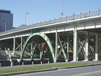
- Laurier BridgeLaurier Avenue BridgeThe Laurier Avenue Bridge is a bridge in Ottawa, Canada. It carries Laurier Avenue over the Rideau Canal and also Colonel By Drive and Queen Elizabeth Driveway. The green steel arches makes the bridge one of the most recognizable in Ottawa. Many of the events of Winterlude are held around the...
- Connects CentretownCentretownCentretown is a neighbourhood in Ottawa, Canada defined by the city as "the area bounded on the north by Gloucester Street and Lisgar Street, on the east by the Rideau Canal, on the south by the Queensway Freeway and on the west by Bronson Avenue." Traditionally it was all of Ottawa west of the...
and the University of OttawaUniversity of OttawaThe University of Ottawa is a bilingual, research-intensive, non-denominational, international university in Ottawa, Ontario. It is one of the oldest universities in Canada. It was originally established as the College of Bytown in 1848 by the Missionary Oblates of Mary Immaculate...
via Laurier Avenue.
- Connects Centretown
- Corktown Footbridge
- Connects CentretownCentretownCentretown is a neighbourhood in Ottawa, Canada defined by the city as "the area bounded on the north by Gloucester Street and Lisgar Street, on the east by the Rideau Canal, on the south by the Queensway Freeway and on the west by Bronson Avenue." Traditionally it was all of Ottawa west of the...
to Campus Transitway Station
- Connects Centretown
- QueenswayQueensway (Ottawa)The Queensway is a major controlled-access freeway running through Ottawa, Ontario, Canada, from Kanata in the west to Orleans in the east. It is the primary east-west transportation artery in the Ottawa-Gatineau area....
- Connects The GlebeThe GlebeThe Glebe is a neighbourhood in Ottawa, Ontario, Canada. It is located just south of Ottawa's downtown area, with its northern border being demarcated by the Queensway highway. It is bounded by the Rideau Canal to the south and east. Many maps show the western edge as Bronson Avenue, but some also...
and CentretownCentretownCentretown is a neighbourhood in Ottawa, Canada defined by the city as "the area bounded on the north by Gloucester Street and Lisgar Street, on the east by the Rideau Canal, on the south by the Queensway Freeway and on the west by Bronson Avenue." Traditionally it was all of Ottawa west of the...
with Old Ottawa EastOld Ottawa EastOld Ottawa East or just Ottawa East is a neighbourhood of Ottawa, Canada. It is located south of Nicholas Street and between the Rideau Canal and the Rideau River. The southern border is generally defined by Main Street and Riverdale Avenue. To the south is the neighbourhood of Old Ottawa South...
via Highway 417.
- Connects The Glebe
- Pretoria BridgePretoria BridgeThe Pretoria Bridge is a lift bridge in Ottawa, Canada. It crosses the Rideau Canal linking the Glebe and Centretown to Old Ottawa East. The bridge was built in 1915, replacing an earlier wooden swing bridge on Argyle Street just to the north...
- Connects Elgin StreetElgin Street (Ottawa)Elgin Street is a street in the Golden Triangle of Ottawa, Ontario, Canada. Originally named Biddy's Lane, it was later named after Lord Elgin....
in The GlebeThe GlebeThe Glebe is a neighbourhood in Ottawa, Ontario, Canada. It is located just south of Ottawa's downtown area, with its northern border being demarcated by the Queensway highway. It is bounded by the Rideau Canal to the south and east. Many maps show the western edge as Bronson Avenue, but some also...
with Hawthorne AvenueHawthorne Avenue (Ottawa)Hawthorne Avenue is a short street in Ottawa, Ontario, Canada. Although short, the western half of the street serves as a major connector for residents of Old Ottawa East and Old Ottawa South with the downtown core, as Hawthorne becomes the Pretoria Bridge in the west which crosses over the Rideau...
in Old Ottawa EastOld Ottawa EastOld Ottawa East or just Ottawa East is a neighbourhood of Ottawa, Canada. It is located south of Nicholas Street and between the Rideau Canal and the Rideau River. The southern border is generally defined by Main Street and Riverdale Avenue. To the south is the neighbourhood of Old Ottawa South...
. This is a Lift bridgeLift bridgeA vertical-lift bridge or lift bridge is a type of movable bridge in which a span rises vertically while remaining parallel with the deck....
.
- Connects Elgin Street
- Bank Street Bridge
- Connects The GlebeThe GlebeThe Glebe is a neighbourhood in Ottawa, Ontario, Canada. It is located just south of Ottawa's downtown area, with its northern border being demarcated by the Queensway highway. It is bounded by the Rideau Canal to the south and east. Many maps show the western edge as Bronson Avenue, but some also...
and Old Ottawa South
- Connects The Glebe
- Bronson Bridge
- Connects The GlebeThe GlebeThe Glebe is a neighbourhood in Ottawa, Ontario, Canada. It is located just south of Ottawa's downtown area, with its northern border being demarcated by the Queensway highway. It is bounded by the Rideau Canal to the south and east. Many maps show the western edge as Bronson Avenue, but some also...
and Carleton UniversityCarleton UniversityCarleton University is a comprehensive university located in the capital of Canada, Ottawa, Ontario. The enabling legislation is The Carleton University Act, 1952, S.O. 1952. Founded as a small college in 1942, Carleton now offers over 65 programs in a diverse range of disciplines. Carleton has...
via Bronson AvenueBronson Avenue (Ottawa)Bronson Avenue is a major north-south arterial road in Ottawa, Ontario, Canada. It runs from downtown at Sparks Street in the north through Centretown, past the Glebe and Carleton University and turns into the Airport Parkway, which is an expressway to the Macdonald-Cartier International...
- Connects The Glebe
- Rail tunnel (just west of Dows Lake)
- Used by O-Train; connects CarletonCarleton Station (OC Transpo)Carleton O-Train Station is located at Carleton University in Ottawa, Ontario.Carleton is currently the only O-Train station with separate tracks and platforms for each direction, in order to allow the two trains working the otherwise single-track line at any given time to pass...
and CarlingCarling Station (OC Transpo)Carling O-Train Station an O-Train station, one block west of the intersection of Carling Avenue and Preston Street in Ottawa, Ontario. It is near Dow's Lake the western terminal of the Rideau Canal skating rink and a key site during the Canadian Tulip Festival in May. The station is also near...
stations
- Used by O-Train; connects Carleton
- Heron Road Bridge
- see above
- Hog's Back BridgeHog's Back BridgeThe Hog's Back Bridge is an asymmetrical swing bridge over the Rideau Canal in Ottawa, Ontario. It carries 3 lanes of Hog's Back Road and a sidewalk. The bridge still swings in the summer when boats exceeding in height need to pass....
- A swing bridge. Connects Riverside DriveRiverside Drive (Ottawa)Riverside Drive is a major road in Ottawa, Ontario, Canada that follows along the eastern bank of the Rideau River. From its northern terminus at the Transitway/Via Rail underpass just south of the Queensway, the road proceeds south to Limebank Road where it continues as River Road until the city...
and Prince of Wales Drive
- A swing bridge. Connects Riverside Drive
Other bridges
Bridges not spanning the above water courses:- Pooley's Bridge
- The oldest bridge entirely within Ottawa http://freepages.genealogy.rootsweb.ancestry.com/~crossroads/cross/johncrossnotes.html, spanning the tailrace in Lebreton Flats
- Somerset Street bridge http://www.ottawa.ca/residents/major_projects/wellington_reconstruct/somerset_bridge_en.html or (a.k.a. "O-Train Bridge" http://city.ottawa.on.ca/residents/major_projects/wellington_reconstruct/30jan08_boards/27_trainbridge_en.html)
- Connects Somerset Street West over the O-Train tracks
Bridges carrying roads or pedestrian ways over or under Higways 417, Highway 416 and Ottawa Highway 174 ar not listed.
See also
- List of crossings of the Ottawa River