

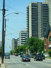
Bronson Avenue (Ottawa)
Encyclopedia
Ottawa
Ottawa is the capital of Canada, the second largest city in the Province of Ontario, and the fourth largest city in the country. The city is located on the south bank of the Ottawa River in the eastern portion of Southern Ontario...
, Ontario
Ontario
Ontario is a province of Canada, located in east-central Canada. It is Canada's most populous province and second largest in total area. It is home to the nation's most populous city, Toronto, and the nation's capital, Ottawa....
, Canada
Canada
Canada is a North American country consisting of ten provinces and three territories. Located in the northern part of the continent, it extends from the Atlantic Ocean in the east to the Pacific Ocean in the west, and northward into the Arctic Ocean...
. It runs from downtown at Sparks Street
Sparks Street
Sparks Street is a street in downtown Ottawa, Canada that was converted into an outdoor pedestrian street in 1966, making it the earliest such street or mall in North America....
in the north through Centretown
Centretown
Centretown is a neighbourhood in Ottawa, Canada defined by the city as "the area bounded on the north by Gloucester Street and Lisgar Street, on the east by the Rideau Canal, on the south by the Queensway Freeway and on the west by Bronson Avenue." Traditionally it was all of Ottawa west of the...
, past the Glebe
The Glebe
The Glebe is a neighbourhood in Ottawa, Ontario, Canada. It is located just south of Ottawa's downtown area, with its northern border being demarcated by the Queensway highway. It is bounded by the Rideau Canal to the south and east. Many maps show the western edge as Bronson Avenue, but some also...
and Carleton University
Carleton University
Carleton University is a comprehensive university located in the capital of Canada, Ottawa, Ontario. The enabling legislation is The Carleton University Act, 1952, S.O. 1952. Founded as a small college in 1942, Carleton now offers over 65 programs in a diverse range of disciplines. Carleton has...
and turns into the Airport Parkway
Airport Parkway (Ottawa)
Airport Parkway is an expressway in Ottawa, Ontario, Canada. It runs from the Ottawa Macdonald-Cartier International Airport to an interchange with Heron Road where it turns into Bronson Avenue.-Route description:...
, which is an expressway to the Macdonald-Cartier International Airport.
Starting as a local road for downtown residents north of Albert Street
Albert Street
Albert Street may refer to:*Albert Street, Brisbane, Queensland, Australia*Albert Street , Ontario, Canada*Albert Street , Saskatchewan, Canada*Albert Street , Latvia*Albert Street , Singapore...
, Bronson quickly gets busier. Bronson Avenue is a four-lane undivided principal arterial road through residential and commercial areas with a speed limit of 50 km/h (31.1 mph) from Albert Street
Albert Street
Albert Street may refer to:*Albert Street, Brisbane, Queensland, Australia*Albert Street , Ontario, Canada*Albert Street , Saskatchewan, Canada*Albert Street , Latvia*Albert Street , Singapore...
to Colonel By Drive
Colonel By Drive
Colonel By Drive is an long scenic parkway in Ottawa, Ontario, Canada. It runs along the Rideau Canal from the end of Sussex Drive at Rideau Street. It then continues south and west to Hog's Back Road, winding through several residential areas and going past Dow's Lake and Carleton University...
, at which point it expands to a six lane divided principal arterial with little or no direct frontage and a speed limit of 70 km/h (43.5 mph). From the stretch south of Sunnyside Avenue, the average speed by drivers is much higher as Bronson becomes an expressway
Limited-access road
A limited-access road known by various terms worldwide, including limited-access highway, dual-carriageway and expressway, is a highway or arterial road for high-speed traffic which has many or most characteristics of a controlled-access highway , including limited or no access to adjacent...
leading onto the Airport Parkway
Airport Parkway (Ottawa)
Airport Parkway is an expressway in Ottawa, Ontario, Canada. It runs from the Ottawa Macdonald-Cartier International Airport to an interchange with Heron Road where it turns into Bronson Avenue.-Route description:...
.
Bronson Avenue is a gateway to the southern neighborhoods of Ottawa and since it is generally faster to take Bronson Avenue than Bank Street
Bank Street (Ottawa)
Bank Street is the major north-south road in Ottawa, Ontario, Canada. It runs south from Wellington Street in downtown Ottawa, south through the neighbourhoods of Centretown, The Glebe, Old Ottawa South, Alta Vista, Hunt Club, and then through the villages of Blossom Park, Leitrim, South...
, the street is usually quite busy, particularly at rush hour
Rush hour
A rush hour or peak hour is a part of the day during which traffic congestion on roads and crowding on public transport is at its highest. Normally, this happens twice a day—once in the morning and once in the evening, the times during when the most people commute...
.
Glebe Collegiate Institute
Glebe Collegiate Institute
Glebe Collegiate Institute is a high school in the Glebe neighbourhood of Ottawa, Ontario, Canada. Administered by the Ottawa-Carleton District School Board, Glebe Collegiate Institute has approximately 1,500 students; students and sports teams are referred to as "Gryphons".The school offers many...
and Carleton University
Carleton University
Carleton University is a comprehensive university located in the capital of Canada, Ottawa, Ontario. The enabling legislation is The Carleton University Act, 1952, S.O. 1952. Founded as a small college in 1942, Carleton now offers over 65 programs in a diverse range of disciplines. Carleton has...
border on Bronson Avenue.
There has been considerable debate about the nature of the road in the past few years; some have called for an expressway to be built in the corridor to link to a twinned Airport Parkway; but that has been extremely unpopular with local residents calling for improved public transit and is unlikely to be built.
Bronson Avenue took its name from Ottawa businessman and politician Erskine Henry Bronson
Erskine Henry Bronson
Erskine Henry Bronson was an American-born Canadian businessman and political figure. He represented the City of Ottawa in the Legislative Assembly of Ontario from 1886 to 1898....
.
Neighbourhoods
Bronson Avenue is considered a boundary line for several Ottawa neighbourhoods:- CentretownCentretownCentretown is a neighbourhood in Ottawa, Canada defined by the city as "the area bounded on the north by Gloucester Street and Lisgar Street, on the east by the Rideau Canal, on the south by the Queensway Freeway and on the west by Bronson Avenue." Traditionally it was all of Ottawa west of the...
- Centretown WestCentretown WestCentretown West is a neighbourhood in Ottawa, Canada. It lies to the west of Bronson Avenue, east of the O-Train tracks, north of Carling Avenue, and south of "Nanny Goat Hill", which is an escarpment to the north of Somerset Street West. To the east lies Centretown, to the north lies Lebreton...
- The GlebeThe GlebeThe Glebe is a neighbourhood in Ottawa, Ontario, Canada. It is located just south of Ottawa's downtown area, with its northern border being demarcated by the Queensway highway. It is bounded by the Rideau Canal to the south and east. Many maps show the western edge as Bronson Avenue, but some also...
- Old Ottawa SouthOld Ottawa SouthOld Ottawa South is an older urban neighbourhood in Ottawa, Canada. As of the Canada 2006 Census, 8,168 people lived in Old Ottawa South, a relatively small and compact neighbourhood, located between the Rideau Canal and the Rideau River . The eastern boundary is defined by Riverdale Avenue and...
Major Intersections
Major intersections (from north to south):- Albert StreetAlbert Street (Ottawa)Albert Street is one of the main east-west roads in downtown Ottawa, Canada. Albert is one way going west. It carries the westbound portion of the transitway through downtown, with Slater Street just to the south carrying the eastbound portion...
- 0.1 km - Slater Street - 0.3 km
- Somerset StreetSomerset Street (Ottawa)Somerset Street is a street in Ottawa, Ontario, Canada. It is divided into Somerset Street East and Somerset Street West by the Rideau Canal.-Somerset Street East:...
- 0.8 km - Gladstone AvenueGladstone AvenueGladstone Avenue is a street in Ottawa running east from the Rideau Canal west to Parkdale Avenue. It is a historically residential street running just south of the downtown core, with a number of small houses in the downtown section now converted to commercial uses.-Landmarks:* Gladstone Avenue...
- 1.2 km - Catherine Street - 1.5 km
- Highway 417Highway 417 (Ontario)King's Highway 417, also known as Highway 417 and the Queensway through Ottawa is a 400-series highways in the Canadian province of Ontario which connects Montreal with Ottawa. It is the backbone of the transportation system in the Ottawa region, where it forms part of the Queensway along with...
- 1.6 km - Carling AvenueCarling AvenueCarling Avenue is a major east-west arterial road in the west end of Ottawa, Ontario, Canada. It runs from March Road in Kanata to Bronson Avenue in the Glebe...
- 2.0 km - Colonel By Drive - 2.9 km
- Sunnyside Avenue - 3.4 km
- Riverside DriveRiverside Drive (Ottawa)Riverside Drive is a major road in Ottawa, Ontario, Canada that follows along the eastern bank of the Rideau River. From its northern terminus at the Transitway/Via Rail underpass just south of the Queensway, the road proceeds south to Limebank Road where it continues as River Road until the city...
- 4.3 km