

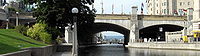
Plaza Bridge (Ottawa)
Encyclopedia
Ottawa
Ottawa is the capital of Canada, the second largest city in the Province of Ontario, and the fourth largest city in the country. The city is located on the south bank of the Ottawa River in the eastern portion of Southern Ontario...
, Ontario
Ontario
Ontario is a province of Canada, located in east-central Canada. It is Canada's most populous province and second largest in total area. It is home to the nation's most populous city, Toronto, and the nation's capital, Ottawa....
, Canada
Canada
Canada is a North American country consisting of ten provinces and three territories. Located in the northern part of the continent, it extends from the Atlantic Ocean in the east to the Pacific Ocean in the west, and northward into the Arctic Ocean...
is an automotive and pedestrian bridge
Bridge
A bridge is a structure built to span physical obstacles such as a body of water, valley, or road, for the purpose of providing passage over the obstacle...
that crosses the Rideau Canal
Rideau Canal
The Rideau Canal , also known as the Rideau Waterway, connects the city of Ottawa, Ontario, Canada on the Ottawa River to the city of Kingston, Ontario on Lake Ontario. The canal was opened in 1832 as a precaution in case of war with the United States and is still in use today, with most of its...
just south of the Ottawa locks. It joins Wellington Street
Wellington Street (Ottawa)
Wellington Street is an important street in Ottawa, Canada most notable for being one of the first two streets laid out in Bytown in 1826 Wellington Street (French: Rue Wellington) is an important street in Ottawa, Canada most notable for being one of the first two streets laid out in Bytown in...
and Elgin Street
Elgin Street (Ottawa)
Elgin Street is a street in the Golden Triangle of Ottawa, Ontario, Canada. Originally named Biddy's Lane, it was later named after Lord Elgin....
in Centretown to the west with Rideau Street to the east. The Chateau Laurier
Château Laurier
The Fairmont Château Laurier is a landmark hotel in Downtown Ottawa, Ontario located near the intersection of Rideau Street and Sussex Drive designed in the Châteauesque style.-History:...
abuts the bridge at the east end, while Parliament Hill
Parliament Hill
Parliament Hill , colloquially known as The Hill, is an area of Crown land on the southern banks of the Ottawa River in downtown Ottawa, Ontario. Its Gothic revival suite of buildingsthe parliament buildings serves as the home of the Parliament of Canada and contains a number of architectural...
is just beyond the west end. It is the northernmost bridge over the canal, just north of the Mackenzie King Bridge
Mackenzie King Bridge
The Mackenzie King Bridge is a bridge in Ottawa, Ontario, Canada. Just a few blocks away from Parliament Hill, south of the Plaza Bridge, it runs in a generally east-west direction, with the east end at the Rideau Centre and Department of National Defence Headquarters. The west end runs between...
.
The bridge is constructed of three masonry spans. The western span is over a roadway along the western bank of the Canal. The central span is over the Canal. The eastern span is over a former railway tunnel running along the east bank of the Canal.
Sappers Bridge
Sappers Bridge was one of Ottawa's first bridges (BytownBytown
Bytown is the former name of Ottawa, Canada's capital city. It was founded on on September 26, 1826, incorporated as a town on January 1, 1850, and superseded by the incorporation of the City of Ottawa on January 1, 1855. The founding was marked by a sod turning, and a letter from Governor General...
at the time), built in 1827 over the Rideau Canal
Rideau Canal
The Rideau Canal , also known as the Rideau Waterway, connects the city of Ottawa, Ontario, Canada on the Ottawa River to the city of Kingston, Ontario on Lake Ontario. The canal was opened in 1832 as a precaution in case of war with the United States and is still in use today, with most of its...
connecting Rideau Street
Rideau Street
Rideau Street is a major street in downtown Ottawa, Ontario, Canada and one of Ottawa's oldest and most famous streets running from Wellington Street in the west to Montreal Road in the east where it connects to the Vanier district...
in Lower Town
Lower Town
Lowertown is a district in the central area of Ottawa, Ontario, Canada to the east of downtown. It is bounded roughly by Rideau Street to the south, Sussex Drive and Ottawa River to the north, the Rideau Canal to the west, and the Rideau River to the east...
with Upper Town. The bridge got its name from the builders, the Royal Sappers and Miners. It was demolished in mid 1912. The current Plaza Bridge connecting Rideau Street with Wellington Street
Wellington Street
Wellington Street is a name of a street in:*Wellington Street , Ontario, Canada*Wellington Street, Hong Kong*Wellington Street, London, England*Wellington Street, Montreal, Quebec, Canada*Wellington Street, Perth, Australia...
near the Rideau Centre
Rideau Centre
Rideau Centre is a three-level shopping centre on Rideau Street in Downtown Ottawa, Ontario, Canada. It borders on Rideau Street , the Rideau Canal, the Mackenzie King Bridge, and Nicholas Street....
stands roughly in its location.
Construction
On September 26th, Dalhousie presented Colonel By, (overseer of the construction of the Rideau CanalRideau Canal
The Rideau Canal , also known as the Rideau Waterway, connects the city of Ottawa, Ontario, Canada on the Ottawa River to the city of Kingston, Ontario on Lake Ontario. The canal was opened in 1832 as a precaution in case of war with the United States and is still in use today, with most of its...
) with a letter authorizing him to divide the land into lots, and sod was turned. Construction of the canal's entrance took place in 1827, dividing Upper Town from Lower town.
Colonel By laid the cornerstone. Construction proceeded in September 1827 and was finished in December. The stone arch bridge was constructed by 15th Company of the Royal Sappers and Miners. The eastern end connected directly to Rideau Street, and its western side joined with a wagon trail that winded its way to where it met Wellington and Bank. The land east of Bank Street had been acquired from Nicholas Sparks by the military, who returned it to him in late 1849, where he commenced its development. Thereafter, Sappers Bridge became connected directly to Sparks Street.
The bridge was modified in the early 1870s with the construction of the Dufferin Bridge. Around the turn of the century, a hole was blasted in Sappers Bridge to allow for rail traffic to pass. A railway station (predating Union Station) was built east of the Rideau Canal, immediately south of the bridge. With the completion of the Alexandra Bridge
Alexandra Bridge
The Royal Alexandra Interprovincial Bridge is a steel truss cantilever bridge spanning the Ottawa River between Ottawa, Ontario and Gatineau, Quebec. It is known locally as both the "Alexandra Bridge" and the "Interprovincial Bridge".-History:...
rail traffic passed from this station onto Hull.
Demolition
Between 1910 and 1912, the area saw a lot of construction, principally the construction of the Union Station and the Chateau Laurier, as well as the need to move railway traffic along the Rideau Canal's eastern side, under the bridge bypassing the west side of the Chateau Laurier and continuing on towards the Royal Alexandra Interprovincial Bridge. The bridge itself was part of this new centralized railway station.By late July 1912, the bridge was demolished to allow for the development of Connaught Place (now Confederation Square) In 1915, two of its stones were placed on the site of Colonel By's home in Major's Hill Park
Major's Hill Park
Major's Hill Park is one of the most notable parks in downtown Ottawa. The park stands above the Rideau Canal at the point where it enters the Ottawa River. Across the canal to the west are the parliament buildings, to the north of the park is the National Gallery of Canada, and to the east are...
.
Dufferin Bridge
The dufferin bridge was built in the early 1870s, forming a triangle with the existing Sappers Bridge. In 1912, both the Sappers Bridge and the Dufferin Bridge were demolished in favour of Connaught Place, today part of Confederation Square.Plaza Bridge
The Plaza Bridge was originally two bridges across the Canal, the Sappers Bridge and the Dufferin Bridge. Construction on the new Plaza Bridge was finished by December 1912.Several buildings, including the Russell Hotel and Ottawa's first City Hall, existed in the place of today's National War Memorial
National War Memorial (Canada)
The National War Memorial , is a tall granite cenotaph with acreted bronze sculptures, that stands in Confederation Square, Ottawa, and serves as the federal war memorial for Canada....
. In the 1930s, the memorial was erected and Elgin Street was re-routed around the Cenotaph, southbound traffic along the west side of the square, and the northbound section along the path of the southern bridge. The bridge was also widened at that time. In the 1990s, the bridge structure was renovated, adding an extra access to the canal via a staircase in the area between the original two bridges.