
.gif)
Bank Street (Ottawa)
Encyclopedia
Ottawa
Ottawa is the capital of Canada, the second largest city in the Province of Ontario, and the fourth largest city in the country. The city is located on the south bank of the Ottawa River in the eastern portion of Southern Ontario...
, Ontario
Ontario
Ontario is a province of Canada, located in east-central Canada. It is Canada's most populous province and second largest in total area. It is home to the nation's most populous city, Toronto, and the nation's capital, Ottawa....
, Canada
Canada
Canada is a North American country consisting of ten provinces and three territories. Located in the northern part of the continent, it extends from the Atlantic Ocean in the east to the Pacific Ocean in the west, and northward into the Arctic Ocean...
. It runs south from Wellington Street in downtown Ottawa, south through the neighbourhoods of Centretown
Centretown
Centretown is a neighbourhood in Ottawa, Canada defined by the city as "the area bounded on the north by Gloucester Street and Lisgar Street, on the east by the Rideau Canal, on the south by the Queensway Freeway and on the west by Bronson Avenue." Traditionally it was all of Ottawa west of the...
, The Glebe
The Glebe
The Glebe is a neighbourhood in Ottawa, Ontario, Canada. It is located just south of Ottawa's downtown area, with its northern border being demarcated by the Queensway highway. It is bounded by the Rideau Canal to the south and east. Many maps show the western edge as Bronson Avenue, but some also...
, Old Ottawa South
Old Ottawa South
Old Ottawa South is an older urban neighbourhood in Ottawa, Canada. As of the Canada 2006 Census, 8,168 people lived in Old Ottawa South, a relatively small and compact neighbourhood, located between the Rideau Canal and the Rideau River . The eastern boundary is defined by Riverdale Avenue and...
, Alta Vista
Alta Vista (Ottawa)
Alta Vista is a neighbourhood in Ottawa, Ontario, Canada. Its boundaries can be broadly described as: Smyth Road in the north, St. Laurent Boulevard in the east, Walkley Road and Heron Road in the south, and Bank Street and Riverside Drive in the west...
, Hunt Club
Hunt Club
Hunt Club is a large suburban neighbourhood in the southern part of Ottawa, Canada. The area is named after the Ottawa Hunt and Golf Club, which used to own much of the land where the community is now situated and is still a major presence...
, and then through the villages of Blossom Park
Blossom Park, Ontario
Blossom Park is a suburban community located in the south-end of the city of Ottawa, Ontario. It is considered an outer-suburb of the city. Before the 2001 city of Ottawa amalgamation it was a suburb of the city of Gloucester.Population : 12,361....
, Leitrim
Leitrim, Ontario
Leitrim is a suburban community and a developing neighbourhood, to Ottawa's rural south in Ontario, Canada, named after the Irish County Leitrim....
, South Gloucester, Greely
Greely, Ontario
Greely is a quickly growing rural village in the southern end of Ottawa, formerly a part of the Township of Osgoode. It has been a part of the City of Ottawa since amalgamation in 2001. Greely is currently the largest rural village in terms of land area and the third largest in terms of population...
, Metcalfe
Metcalfe, Ontario
Metcalfe is a large village in the Osgoode Ward of the city of Ottawa, Ontario, Canada. The local agricultural fair, the Metcalfe Fair, has been held each fall since 1856....
, Spring Hill, and Vernon
Vernon, Ontario
Vernon is a small village with a population of 597 people in the Osgoode Ward of the city of Ottawa, Ontario, Canada.- Library :The Vernon branch of the Ottawa Public Library makes its home in an 1882 heritage building that was the community's one-room schoolhouse. It was recently renovated to have...
before exiting the city limits at Belmeade Road.
Bank Street made up much of Ontario Highway 31 before it was downloaded in 1998 (all of it south of Heron Road
Heron Road (Ottawa)
Heron Road is a major road in Ottawa, Ontario, Canada. It runs from Walkley Road at an angle to the Rideau River, where it turns into Baseline Road. Heron is home to the Public Works and Government Services Canada headquarters, as well as the Canada Post headquarters and the Edward Drake Building...
). Currently it is also known as Ottawa Road #31. Bank Street is also popularly known as Metcalfe Road south of its junction with Conroy Road
Conroy Road (Ottawa)
Conroy Road is a road in the City of Ottawa, Ontario, Canada. It runs from Walkley Road in the north to Bank Street in the south. Conroy Road forms the eastern fringe of the neighbourhood of Blossom Park, Ontario and ends in the community of Kemp Park, Ontario. Conroy Road is home to Pine Grove...
, though this name is not officially recognized.
Features

Wellington Street (Ottawa)
Wellington Street is an important street in Ottawa, Canada most notable for being one of the first two streets laid out in Bytown in 1826 Wellington Street (French: Rue Wellington) is an important street in Ottawa, Canada most notable for being one of the first two streets laid out in Bytown in...
and Gladstone Avenue in downtown, Bank Street is a shopping and business development district officially known as the "Bank Street Promenade" and the street is lined with common signage affixed to streetlights and street-level advertising billboards showing this distinction.
The area between Somerset Street
Somerset Street (Ottawa)
Somerset Street is a street in Ottawa, Ontario, Canada. It is divided into Somerset Street East and Somerset Street West by the Rideau Canal.-Somerset Street East:...
West and Gladstone Avenue (within the Bank Street Promenade) is considered the centre of Ottawa's burgeoning gay village
Gay village
A gay village is an urban geographic location with generally recognized boundaries where a large number of lesbian, gay, bisexual, and transgender people live or frequent...
, characterized by a small concentration of businesses targeted to Ottawa's gay community. In 2011, the city officially unveiled signs identifying the neighbourhood as Ottawa's gay village, at the intersections of Somerset, James and Nepean Streets with Bank Street.
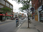
Travelling south, there exists a shopping district in The Glebe running exclusively along Bank Street from approximately the Queensway
Queensway (Ottawa)
The Queensway is a major controlled-access freeway running through Ottawa, Ontario, Canada, from Kanata in the west to Orleans in the east. It is the primary east-west transportation artery in the Ottawa-Gatineau area....
to Holmwood Avenue. Bank Street is home to Lansdowne Park
Lansdowne Park
Lansdowne Park is a historic sports, exhibition and entertainment facility in Ottawa, Ontario, Canada, owned by the City of Ottawa. It is located along Bank Street and is adjacent to the Rideau Canal, in central Ottawa...
where the Ottawa 67's
Ottawa 67's
The Ottawa 67’s are a junior ice hockey team based in Ottawa, Ontario. They have played in the Ontario Hockey League since 1967, Canada's centennial year. The current coach is Chris Byrne.-History:...
play and where the currently-defunct Ottawa Renegades
Ottawa Renegades
Ottawa Renegades was the most recent name of a Canadian Football League team based in Ottawa, Ontario founded in 2002, seven years after the storied Ottawa Rough Riders folded...
used to play. Even further south, after the road passes over the Rideau Canal
Rideau Canal
The Rideau Canal , also known as the Rideau Waterway, connects the city of Ottawa, Ontario, Canada on the Ottawa River to the city of Kingston, Ontario on Lake Ontario. The canal was opened in 1832 as a precaution in case of war with the United States and is still in use today, with most of its...
on the Bank Street Bridge
Bank Street Bridge
The Bank Street Bridge, officially known as the Bank Street Canal Bridge, is a bridge in Ottawa, Ontario, Canada, that carries Bank Street over the Rideau Canal. It links the Glebe to Old Ottawa South. It also passes over the Queen Elizabeth Driveway and Colonel By Drive.A wooden bridge was first...
, Bank Street is home to the Billings Bridge Plaza
Billings Bridge Plaza
The Billings Bridge Plaza is a shopping centre located in Ottawa, Canada. Originally built in 1954, it was the first shopping centre built in the city. It did not become enclosed until 1972. It is located immediately south of the Rideau River on the corner of Bank Street and Riverside Drive,...
and eventually, the South Keys Shopping Centre.
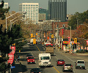
Bank Street north of Billings Bridge
Billings Bridge
Billings Bridge is a bridge over the Rideau River in Ottawa. Bank Street passes over the river by way of this bridge. The bridge was named after Braddish Billings, who settled in this area and established a farm nearby in 1812. The first bridge, originally called Farmers Bridge, was built over the...
is an historic urban arterial road, often with many more pedestrians than vehicular traffic and significant parking issues, hence the flow is generally quite slow. South of Billings Bridge to Leitrim Road
Leitrim Road (Ottawa)
Leitrim Road is an east-west road in Ottawa's south end. It connects River Road in the West, passes south of the Macdonald-Cartier International Airport and continues east to Russell Road. Leitrim briefly cuts off in two areas. In the western section, one must travel briefly on Limebank Road in...
, the street turns into a more modern four-lane (or five-lane) urban arterial, which flows much better despite the 50 km/h (30 mph) speed limit on the northern half and 60 km/h (about 40 mph) from South Keys southward. South of Leitrim it is a rural two-lane highway with an 80 km/h speed limit until the community of Vernon. Recently, just south of Leitrim Road, Bank Street gives access to a developing neighborhood called Findlay Creek that will become quite significant in the long term, and it will also provide access (after secondary roads are extended) to the community of Riverside South.
Bank Street also serves in some contexts as an unofficial division between "eastern" and "western" Ottawa. For example, prior to the takeover of Maclean-Hunter
Maclean-Hunter
Maclean-Hunter was a Canadian communications company, which had diversified holdings in radio, television, magazines, newspapers and cable television distribution....
by Rogers Cable
Rogers Cable
Rogers Cable Inc., a subsidiary of Rogers Communications Inc., is Canada's largest cable television service provider with about 2.25 million television customers, and over 930,000 Internet subscribers, in Manitoba, Southern & Eastern Ontario, New Brunswick and Newfoundland and Labrador.The...
in 1994, the street marked the division between those cable companies' service areas in Ottawa: cable subscribers west of Bank Street were served by Maclean-Hunter, while cable subscribers east of Bank Street were served by Rogers.
Name of the street
Contrary to popular belief, the street is not named after the Bank of CanadaBank of Canada
The Bank of Canada is Canada's central bank and "lender of last resort". The Bank was created by an Act of Parliament on July 3, 1934 as a privately owned corporation. In 1938, the Bank became a Crown corporation belonging to the Government of Canada...
headquarters at the corner of Bank Street and Wellington Street. The street name
Street name
A street name or odonym is an identifying name given to a street. The street name usually forms part of the address...
dates back to the 19th century, whereas the bank was founded in 1934. It's believed that the road was named this because it originally went from the "bank" of the Ottawa River
Ottawa River
The Ottawa River is a river in the Canadian provinces of Ontario and Quebec. For most of its length, it now defines the border between these two provinces.-Geography:...
at its northern end to that of the Rideau River to the south. However, the road was originally called Esther Street in honour of Colonel By's wife. Interestingly, today Bank Street officially ends at Wellington Street and the portion of the street running closest to the actual riverbank is federal Crown land
Crown land
In Commonwealth realms, Crown land is an area belonging to the monarch , the equivalent of an entailed estate that passed with the monarchy and could not be alienated from it....
for the Parliamentary Precinct
Parliament Hill
Parliament Hill , colloquially known as The Hill, is an area of Crown land on the southern banks of the Ottawa River in downtown Ottawa, Ontario. Its Gothic revival suite of buildingsthe parliament buildings serves as the home of the Parliament of Canada and contains a number of architectural...
of the Parliament of Canada
Parliament of Canada
The Parliament of Canada is the federal legislative branch of Canada, seated at Parliament Hill in the national capital, Ottawa. Formally, the body consists of the Canadian monarch—represented by her governor general—the Senate, and the House of Commons, each element having its own officers and...
.
Bank Street rehabilitation
Portions of Bank Street have undergone major reconstruction each year since 2006. The City of Ottawa held public consultations for a major redevelopment of Bank Street between Wellington Street and the Rideau CanalRideau Canal
The Rideau Canal , also known as the Rideau Waterway, connects the city of Ottawa, Ontario, Canada on the Ottawa River to the city of Kingston, Ontario on Lake Ontario. The canal was opened in 1832 as a precaution in case of war with the United States and is still in use today, with most of its...
. Consultations for the area between Laurier Avenue
Laurier Avenue (Ottawa)
Laurier Avenue is a central east west street running through Ottawa, Canada. Originally known as "Maria Street" and "Theodore Street" , it was renamed in honour of Canadian Prime Minister Sir Wilfrid Laurier...
West and Gladstone Avenue took place February 15, 2006. The discussions were dominated by requests for redevelopment between Nepean Street and Gladstone Avenue. Other suggestions included developing a more developed arts
ARts
aRts, which stands for analog Real time synthesizer, is an audio framework that is no longer under development. It is best known for previously being used in KDE to simulate an analog synthesizer....
and entertainment
Entertainment
Entertainment consists of any activity which provides a diversion or permits people to amuse themselves in their leisure time. Entertainment is generally passive, such as watching opera or a movie. Active forms of amusement, such as sports, are more often considered to be recreation...
district in the same area. The Bank Street redevelopment will likely occur over a number of years.
Major intersections (from North to South)
- Wellington StreetWellington Street (Ottawa)Wellington Street is an important street in Ottawa, Canada most notable for being one of the first two streets laid out in Bytown in 1826 Wellington Street (French: Rue Wellington) is an important street in Ottawa, Canada most notable for being one of the first two streets laid out in Bytown in...
- Somerset StreetSomerset Street (Ottawa)Somerset Street is a street in Ottawa, Ontario, Canada. It is divided into Somerset Street East and Somerset Street West by the Rideau Canal.-Somerset Street East:...
- Gladstone AvenueGladstone AvenueGladstone Avenue is a street in Ottawa running east from the Rideau Canal west to Parkdale Avenue. It is a historically residential street running just south of the downtown core, with a number of small houses in the downtown section now converted to commercial uses.-Landmarks:* Gladstone Avenue...
- Highway 417Highway 417 (Ontario)King's Highway 417, also known as Highway 417 and the Queensway through Ottawa is a 400-series highways in the Canadian province of Ontario which connects Montreal with Ottawa. It is the backbone of the transportation system in the Ottawa region, where it forms part of the Queensway along with...
- Riverside DriveRiverside Drive (Ottawa)Riverside Drive is a major road in Ottawa, Ontario, Canada that follows along the eastern bank of the Rideau River. From its northern terminus at the Transitway/Via Rail underpass just south of the Queensway, the road proceeds south to Limebank Road where it continues as River Road until the city...
- Heron RoadHeron Road (Ottawa)Heron Road is a major road in Ottawa, Ontario, Canada. It runs from Walkley Road at an angle to the Rideau River, where it turns into Baseline Road. Heron is home to the Public Works and Government Services Canada headquarters, as well as the Canada Post headquarters and the Edward Drake Building...
- Alta Vista DriveAlta Vista DriveAlta Vista Drive is a suburban road in Ottawa, Ontario, Canada. It runs from Bank Street in the south to Industrial Avenue in the north covering the neighbourhoods of Ridgemont, Alta Vista and Riverview....
- Walkley Road
- Hunt Club RoadHunt Club Road (Ottawa)Hunt Club Road also known as Ottawa Road #32, is a major east-west route in Ottawa, Ontario, Canada. Hunt Club originally ran from Albion Road to Riverside Drive, but was extended east to Hawthorne Road in the late 1980s. The section between Bank Street and Riverside Drive, originally only one lane...
- Albion RoadAlbion Road (Ottawa)Albion Road is an important north-south road in the southern part of Ottawa, Ontario, Canada. The street begins in the north as Albion Road North, at Walkley Road....
- Conroy RoadConroy Road (Ottawa)Conroy Road is a road in the City of Ottawa, Ontario, Canada. It runs from Walkley Road in the north to Bank Street in the south. Conroy Road forms the eastern fringe of the neighbourhood of Blossom Park, Ontario and ends in the community of Kemp Park, Ontario. Conroy Road is home to Pine Grove...
- Leitrim RoadLeitrim Road (Ottawa)Leitrim Road is an east-west road in Ottawa's south end. It connects River Road in the West, passes south of the Macdonald-Cartier International Airport and continues east to Russell Road. Leitrim briefly cuts off in two areas. In the western section, one must travel briefly on Limebank Road in...
- Mitch Owens Road
- Snake Island Road
- Dalmeny Road
- Tiffany Road
Areas/Communities
- Downtown OttawaDowntown OttawaDowntown Ottawa is the central area of Ottawa, Ontario, Canada. Like other downtowns it is the commercial and economic centre of the city. It is sometimes referred to as the Central Business District and contains Ottawa's financial district. It is bordered by the Ottawa River to the north, the...
- CentretownCentretownCentretown is a neighbourhood in Ottawa, Canada defined by the city as "the area bounded on the north by Gloucester Street and Lisgar Street, on the east by the Rideau Canal, on the south by the Queensway Freeway and on the west by Bronson Avenue." Traditionally it was all of Ottawa west of the...
- The GlebeThe GlebeThe Glebe is a neighbourhood in Ottawa, Ontario, Canada. It is located just south of Ottawa's downtown area, with its northern border being demarcated by the Queensway highway. It is bounded by the Rideau Canal to the south and east. Many maps show the western edge as Bronson Avenue, but some also...
- Ottawa SouthOld Ottawa SouthOld Ottawa South is an older urban neighbourhood in Ottawa, Canada. As of the Canada 2006 Census, 8,168 people lived in Old Ottawa South, a relatively small and compact neighbourhood, located between the Rideau Canal and the Rideau River . The eastern boundary is defined by Riverdale Avenue and...
- Billings BridgeBillings BridgeBillings Bridge is a bridge over the Rideau River in Ottawa. Bank Street passes over the river by way of this bridge. The bridge was named after Braddish Billings, who settled in this area and established a farm nearby in 1812. The first bridge, originally called Farmers Bridge, was built over the...
- South KeysSouth Keys Station (OC Transpo)South Keys is a bus station on Ottawa's transitway system. Operated by OC Transpo, it is located at Bank Street and the Airport Parkway at the south end of the South Keys shopping complex. It is the main terminus of Route 97 .This is the last station on the transitway...
- Blossom Park
- Findlay Creek/Leitrim
- GreelyGreely, OntarioGreely is a quickly growing rural village in the southern end of Ottawa, formerly a part of the Township of Osgoode. It has been a part of the City of Ottawa since amalgamation in 2001. Greely is currently the largest rural village in terms of land area and the third largest in terms of population...
- MetcalfeMetcalfe, OntarioMetcalfe is a large village in the Osgoode Ward of the city of Ottawa, Ontario, Canada. The local agricultural fair, the Metcalfe Fair, has been held each fall since 1856....
- VernonVernon, OntarioVernon is a small village with a population of 597 people in the Osgoode Ward of the city of Ottawa, Ontario, Canada.- Library :The Vernon branch of the Ottawa Public Library makes its home in an 1882 heritage building that was the community's one-room schoolhouse. It was recently renovated to have...
As a Provincial Highway
Highway 31 was formed in 1927, and started at the junction of Highway 2Highway 2 (Ontario)
King's Highway 2, usually referred to simply as Highway 2 is a provincially maintained highway in Ontario. Once the primary east–west route across the southern end of the province, Highway 2 became mostly redundant in the 1960s following the completion of Highway 401, which more or less...
in Morrisburg, Ontario. It traveled north through the town of Winchester, and eventually into Ottawa. The road was paved in stages, but was fully paved by 1936. The road's designation of Highway 31 was extended from the Dundas-Stormont-Glengary/Russell-Prescott county line into Ottawa later that same year. While maintaining its alignment along Bank Street for its entire history, the road was re-aligned along Canal Drive (now today's Queen Elizabeth Drive). From here, it became less clear where the northern terminus of the road was located, as Ottawa posted Highway 31 as a scenic route within its limits along Heron Road
Heron Road (Ottawa)
Heron Road is a major road in Ottawa, Ontario, Canada. It runs from Walkley Road at an angle to the Rideau River, where it turns into Baseline Road. Heron is home to the Public Works and Government Services Canada headquarters, as well as the Canada Post headquarters and the Edward Drake Building...
and Bronson Avenue (concurrent
Concurrency (road)
A concurrency, overlap, or coincidence in a road network is an instance of one physical road bearing two or more different highway, motorway, or other route numbers...
with Highway 16
Highway 16 (Ontario)
King's Highway 16, commonly known as Highway 16 and historically as the Prescott Highway, is a provincially maintained highway in the Canadian province of Ontario. The highway once travelled from near Prescott to Ottawa. However, its length was truncated significantly when most of the route was...
) before terminating in downtown, while the Ministry of Transportation noted no changes in road length (78 km / 48.8 mi). This is presumed to be a connecting link
Connecting Link
The Connecting Link program is a provincial subsidy provided to municipalities to assist with road construction, maintenance and repairs in the Canadian province of Ontario. Roads which are designated as connecting links form the portions of provincial highways through built-up communities which...
between Highway 31 and The Queensway
Queensway (Ottawa)
The Queensway is a major controlled-access freeway running through Ottawa, Ontario, Canada, from Kanata in the west to Orleans in the east. It is the primary east-west transportation artery in the Ottawa-Gatineau area....
(Highway 417
Highway 417 (Ontario)
King's Highway 417, also known as Highway 417 and the Queensway through Ottawa is a 400-series highways in the Canadian province of Ontario which connects Montreal with Ottawa. It is the backbone of the transportation system in the Ottawa region, where it forms part of the Queensway along with...
), but these scenic route
Scenic route
A scenic route, tourist road, tourist route, theme route, or scenic byway is a specially designated road or waterway that travels through an area of natural or cultural beauty...
s/connecting links were all decommissioned by 1960. The road was also re-aligned along the Winchester Bypass, when it was completed and opened in 1974, but no other changes were made to the road since then, until being fully decommissioned as a provincial highway, in 1998.