

List of airports in Algeria
Encyclopedia
Airport
An airport is a location where aircraft such as fixed-wing aircraft, helicopters, and blimps take off and land. Aircraft may be stored or maintained at an airport...
s in Algeria
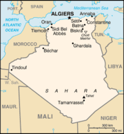
Algeria
Algeria , officially the People's Democratic Republic of Algeria , also formally referred to as the Democratic and Popular Republic of Algeria, is a country in the Maghreb region of Northwest Africa with Algiers as its capital.In terms of land area, it is the largest country in Africa and the Arab...
, grouped by type and sorted by location.
Algeria, officially known as the People's Democratic Republic of Algeria, is a country located in North Africa
North Africa
North Africa or Northern Africa is the northernmost region of the African continent, linked by the Sahara to Sub-Saharan Africa. Geopolitically, the United Nations definition of Northern Africa includes eight countries or territories; Algeria, Egypt, Libya, Morocco, South Sudan, Sudan, Tunisia, and...
. It is the largest country on the Mediterranean Sea, the second largest on the African continent and the Arab world after Sudan
Sudan
Sudan , officially the Republic of the Sudan , is a country in North Africa, sometimes considered part of the Middle East politically. It is bordered by Egypt to the north, the Red Sea to the northeast, Eritrea and Ethiopia to the east, South Sudan to the south, the Central African Republic to the...
, as well as the eleventh-largest country in the world in terms of land area. It is bordered by Tunisia
Tunisia
Tunisia , officially the Tunisian RepublicThe long name of Tunisia in other languages used in the country is: , is the northernmost country in Africa. It is a Maghreb country and is bordered by Algeria to the west, Libya to the southeast, and the Mediterranean Sea to the north and east. Its area...
in the northeast, Libya
Libya
Libya is an African country in the Maghreb region of North Africa bordered by the Mediterranean Sea to the north, Egypt to the east, Sudan to the southeast, Chad and Niger to the south, and Algeria and Tunisia to the west....
in the east, Niger
Niger
Niger , officially named the Republic of Niger, is a landlocked country in Western Africa, named after the Niger River. It borders Nigeria and Benin to the south, Burkina Faso and Mali to the west, Algeria and Libya to the north and Chad to the east...
in the southeast, Mali
Mali
Mali , officially the Republic of Mali , is a landlocked country in Western Africa. Mali borders Algeria on the north, Niger on the east, Burkina Faso and the Côte d'Ivoire on the south, Guinea on the south-west, and Senegal and Mauritania on the west. Its size is just over 1,240,000 km² with...
and Mauritania
Mauritania
Mauritania is a country in the Maghreb and West Africa. It is bordered by the Atlantic Ocean in the west, by Western Sahara in the north, by Algeria in the northeast, by Mali in the east and southeast, and by Senegal in the southwest...
in the southwest, a few kilometers of the Moroccan-controlled Western Sahara
Western Sahara
Western Sahara is a disputed territory in North Africa, bordered by Morocco to the north, Algeria to the northeast, Mauritania to the east and south, and the Atlantic Ocean to the west. Its surface area amounts to . It is one of the most sparsely populated territories in the world, mainly...
in the southwest, Morocco
Morocco
Morocco , officially the Kingdom of Morocco , is a country located in North Africa. It has a population of more than 32 million and an area of 710,850 km², and also primarily administers the disputed region of the Western Sahara...
in the west and northwest, and the Mediterranean Sea
Mediterranean Sea
The Mediterranean Sea is a sea connected to the Atlantic Ocean surrounded by the Mediterranean region and almost completely enclosed by land: on the north by Anatolia and Europe, on the south by North Africa, and on the east by the Levant...
in the north. Algeria is divided into 48 provinces (wilayas), 553 districts
Districts of Algeria
The provinces of Algeria are divided into 553 districts . The capital of a district is called a district seat...
(daïra
Daïra
A daïra |circle]]; plural dawaïr) is an administrative division of a wilaya in Algeria and in Western Sahara. Another transliteration of the word is Daerah.*Daïra of Algeria*Daïra of Western Sahara-See also:* Provinces of Algeria...
s) and 1,541 communes
Communes of Algeria
This is a list of all communes in the North African country of Algeria. Currently, there are 1,541 communes in the country. The population data is from June 25, 1998.-See also:* List of cities in Algeria* List of postal codes of Algerian cities...
or municipalities.
Airports
Airport names shown in bold indicate the airport has scheduled service on commercial airlines.| City served | Province | ICAO ICAO airport code The ICAO airport code or location indicator is a four-character alphanumeric code designating each airport around the world. These codes are defined by the International Civil Aviation Organization, and published in ICAO Document 7910: Location Indicators.The ICAO codes are used by air traffic... |
IATA IATA airport code An IATA airport code, also known an IATA location identifier, IATA station code or simply a location identifier, is a three-letter code designating many airports around the world, defined by the International Air Transport Association... |
Airport name | Coordinates Geographic coordinate system A geographic coordinate system is a coordinate system that enables every location on the Earth to be specified by a set of numbers. The coordinates are often chosen such that one of the numbers represent vertical position, and two or three of the numbers represent horizontal position... |
AIP/Chart |
|---|---|---|---|---|---|---|
| International airports | ||||||
| Adrar Adrar, Algeria Adrar is a town and commune in Algeria, based around an oasis of the Sahara Desert and the administrative capital of the second largest province in Algeria: Adrar Province.... |
Adrar Adrar Province Adrar is a province in southwestern Algeria, named after its capital Adrar. It is the second-largest province, with an area of 427,368 km²... |
DAUA | AZR | Touat-Cheikh Sidi Mohamed Belkebir Airport | 27°50′21"N 00°11′07"W | AIP Chart |
| Algiers Algiers ' is the capital and largest city of Algeria. According to the 1998 census, the population of the city proper was 1,519,570 and that of the urban agglomeration was 2,135,630. In 2009, the population was about 3,500,000... |
Algiers | DAAG | ALG | Houari Boumediene Airport | 36°41′40"N 03°13′01"E | AIP Chart |
| Annaba Annaba Annaba is a city in the northeastern corner of Algeria near the river Seybouse. It is located in Annaba Province. With a population of 257,359 , it is the fourth largest city in Algeria. It is a leading industrial centre in eastern Algeria.... |
Annaba Annaba Province Annaba is a small province in the north-eastern corner of Algeria. Its capital, Annaba is Algeria's main port for mineral exports.-Administrative divisions:The province is divided into 6 districts and 12 municipalities.The districts are:... |
DABB | AAE | Rabah Bitat Airport Rabah Bitat Airport Rabah Bitat Airport , formerly known as Les Salines Airport, and popularly as El Mellah Airport is an international airport located 9 km south of Annaba, a city in Algeria... |
36°49′20"N 07°48′34"E | AIP Chart |
| Constantine Constantine, Algeria Constantine is the capital of Constantine Province in north-eastern Algeria. It was the capital of the same-named French département until 1962. Slightly inland, it is about 80 kilometres from the Mediterranean coast, on the banks of Rhumel river... |
Constantine Constantine Province Constantine is one of the 48 provinces of Algeria, whose capital is the city of the same name.- Adminsitrative divisions :The province is divided into 6 districts, which are subdivided into 12 communes or municipalities.-Districts:... |
DABC | CZL | Mohamed Boudiaf Airport Mohamed Boudiaf International Airport Mohamed Boudiaf International Airport , also known as Mohamed Boudiaf Airport, is an airport in Algeria, located approximately 9km south of Constantine; about 320km east-southeast of Algiers.... |
36°17′07"N 06°37′09"E | AIP Chart |
| Ghardaïa Ghardaïa Ghardaïa is the capital city of Ghardaïa Province, Algeria. The commune of Ghardaïa has a population of 104,645, with 82,500 in the main city according to 2005 estimates. It is located in northern-central Algeria in the Sahara Desert and lies along the left bank of the Wadi Mzab... |
Ghardaïa Ghardaïa Province Ghardaïa is a province in eastern Algeria, named after its capital Ghardaïa. The M'Zab Valley, located there, is a UNESCO World Heritage Site.-Administrative divisions:... |
DAUG | GHA | Noumérat - Moufdi Zakaria Airport Noumérat - Moufdi Zakaria Airport Noumérat - Moufdi Zakaria Airport , also known as Noumerate Airport, is a public airport serving Ghardaïa, the capital of the Ghardaïa Province in Algeria. It is located southeast of the city... |
32°22′54"N 03°47′58"E | AIP Chart |
| Hassi Messaoud Hassi Messaoud Hassi Messaoud is a town in Ouargla province, southeast Algeria, north Africa. Oil was discovered there in 1956 and the town's prominence has grown rapidly since then. It is an oil refinery town named after the first oil well. A water well, dug in 1917, can be found on the airport side of town... |
Ouargla Ouargla Province Ouargla or Warqla is a province in eastern Algeria. Its capital is Ouargla. Other localities include Temacine, Touggourt, and Hassi Messaoud. It contains the Issaouane Erg desert.-History:... |
DAUH | HME | Oued Irara - Krim Belkacem Airport | 31°40′26"N 06°08′26"E | AIP Chart |
| In Aménas In Amenas In Aménas is a town in eastern Algeria, near the border with Libya. The largest Liquefied Natural Gas joint development project in Algeria started here in 2006.-Transport:... |
Illizi Illizi Province Illizi is a province in the south-eastern corner of Algeria named after its eponymous seat.It borders Libya to the east, Ouargla Province to the north and, Tamanghasset Province to the east and south.-Administrative divisions:... |
DAUZ | IAM | In Aménas Airport In Aménas Airport In Aménas Airport or Zarzaitine Airport , is an airport serving In Aménas, a town in the Illizi Province of southeastern Algeria. It is located east of In Aménas.In 2007, the airport handled 145,070 passengers and had 3,627 aircraft movements.... (Zarzaïtine Airport) |
28°03′05"N 09°38′34"E | AIP Chart |
| Oran Oran Oran is a major city on the northwestern Mediterranean coast of Algeria, and the second largest city of the country.It is the capital of the Oran Province . The city has a population of 759,645 , while the metropolitan area has a population of approximately 1,500,000, making it the second largest... / Es Sénia Es Sénia Es Sénia is a municipality in Oran Province, Algeria. It is the seat of Es Sénia District. It contains a university as well as the international airport of Oran Es Sénia.... |
Oran Oran Province Oran is a province in Algeria whose seat is the city of the same name.-Geography:It is located in the northwestern part of the country. Its population is 1,584,607 and it covers a total area of 2,114 km²... |
DAOO | ORN | Oran Es Sénia Airport Oran Es Sénia Airport Oran Es Sénia Airport is an airport located 4.7 nm south of Oran, near Es Sénia, in Algeria.-History:During World War II, La Sénia Airport was first used by the French Air Force as a military airfield, first by the Armée de l'Air, and after June 1940, by the Armistice Air Force of the Vichy... |
35°37′38"N 00°36′41"W | AIP Chart |
| Tamanrasset | Tamanrasset Tamanrasset Province Tamanrasset or Tamanghasset is the largest province in Algeria. It was named after its province seat: Tamanrasset. The Province has two national parks, more than any other in Algeria. They are: Tassili n'Ajjer National Park and Ahaggar National Park... |
DAAT | TMR | Aguenar - Hadj Bey Akhamok Airport | 22°48′40"N 05°27′03"E | AIP Chart |
| Tébessa Tébessa Tébessa is the capital city of Tébessa Province, Algeria, 20 kilometers west from the border with Tunisia. Nearby is also a phosphate mine. The city is famous for the traditional Algerian carpets in the region, and is home to over 161,440 people.-History:... |
Tébessa Tébessa Province Tébessa is a province of Algeria. Tébessa is also the name of the capital, which in ancient times it was known as Theveste. Another important city is El Ouenza.Tebessa is located only 20 kilometers west from Tunisia border.... |
DABS | TEE | Cheikh Larbi Tébessi Airport | 35°25′57"N 08°07′32"E | AIP Chart |
| Tlemcen Tlemcen Tlemcen is a town in Northwestern Algeria, and the capital of the province of the same name. It is located inland in the center of a region known for its olive plantations and vineyards... |
Tlemcen Tlemcen Province Tlemcen is a province in northwestern Algeria. The Tlemcen National Park is located there.-Administrative divisions:The province is divided into 20 districts , which are further divided into 53 communes or municipalities.... |
DAON | TLM | Zenata - Messali El Hadj Airport | 35°00′55"N 01°27′03"W | AIP Chart |
| National airports | ||||||
| Batna | Batna Batna Province Batna is a wilaya of Algeria. Capital is Batna. Localities in this province include Barika, Merouana and Timgad. Belezma National Park is there.- Administrative divisions :It is made up of 22 districts and 61 municipalities.The districts are:... |
DABT | BLJ | Mostépha Ben Boulaid Airport Batna Airport Batna Airport , also known as Batna International Airport, is an airport near Batna, Algeria.-Airlines and destinations:-External links:* *... |
35°45′33"N 06°19′12"E | AIP Chart |
| Béjaïa Béjaïa Béjaïa, Vgaiet or Bejaya is a Mediterranean port city on the Gulf of Béjaïa in Algeria; it is the capital of Béjaïa Province, Kabylia. Under French rule, it was formerly known under various European names, such as Budschaja in German, Bugia in Italian, and Bougie... |
Béjaïa Béjaïa Province Béjaïa is a province of Algeria. The capital city is Béjaïa. Gouraya National Park is there. A population of the endangered primate, Barbary Macaque is found within this the province's Gouraya National Park; this canid has a severely restricted and disjunctive range.-Administrative divisions:The... |
DAAE | BJA | Soummam - Abane Ramdane Airport | 36°42′43"N 05°04′10"E | AIP Chart |
| Bordj Mokhtar Bordj Mokhtar Bordj Badji Mokhtar is a desert town in southwestern Algeria near the border with Mali, served by Bordj Mokhtar Airport.... |
Adrar Adrar Province Adrar is a province in southwestern Algeria, named after its capital Adrar. It is the second-largest province, with an area of 427,368 km²... |
DATM | BMW | Bordj Mokhtar Airport Bordj Mokhtar Airport Bordj Mokhtar Airport is an airport in Bordj Badji Mokhtar, Algeria .-Airlines and destinations:The only airline currently operating regular flights to/from the airport is Air Algérie.... |
21°22′30"N 00°55′26"E | AIP Chart |
| Bou Saâda Bou Saada Bou Saada is a town and municipality in M'Sila Province, Algeria, situated 245 km south of Algiers. The municipality population was estimated at 134,000 in 2008.... |
M'Sila M'Sila Province M'Sila is a province of northern Algeria. It has a population of 1 million people and an area of 18,718 km², while its capital, also called M'sila, home to M'Sila University, has a population of about 100,000. Some localities in this wilaya are Bou Saada and Maadid. Chott El Hodna, a salt... |
DAAD | BUJ | Bou Saada Airport Ain Eddis Airport Ain Eddis Airport is an airport located 7.5 nm north of Bou Saada, Algeria.... |
35°19′53"N 04°12′16"E | AIP Chart |
| Djanet Djanet Djanet is an oasis city in southeast Algeria. It is located in Illizi Province, 412 kilometers from Illizi. It is inhabited by the Kel Ajjer Tuareg people. It is the capital of Djanet District.-Transport:... |
Illizi Illizi Province Illizi is a province in the south-eastern corner of Algeria named after its eponymous seat.It borders Libya to the east, Ouargla Province to the north and, Tamanghasset Province to the east and south.-Administrative divisions:... |
DAAJ | DJG | Tiska Airport Djanet Inedbirene Airport Djanet Inedbirene Airport is an airport in Djanet, Algeria.-Airlines and destinations:-External links:*... |
24°17′35"N 09°27′07"E | AIP Chart |
| Chlef Chlef Chlef is the capital of Chlef Province, Algeria. It is home to the soccer club ASO Chlef, the Hassiba Ben Bouali university, and the basilica of Saint Reparatus, which is home to the oldest Christian labyrinth in the world.... (Ech-Cheliff) |
Chlef Chlef Province Chlef is a province in Algeria, and has about 1 million inhabitants. Its capital is Chlef. Another locality is Ténès, on the Mediterranean Sea.-Administrative divisions:... |
DAOI | QAS | Chlef Airport Chlef International Airport Aéroport International de Chlef , also known as Aboubakr Belkaid Airport, is an airport located north of Chlef, a city in Algeria.During World War II, the facility was known as "Warnier Airfield". It was a major Twelfth Air Force base of operations during the North African Campaign against the... (Ech-Cheliff Airport) |
36°12′45"N 01°19′54"E | |
| El Goléa El Golea El Golea is an oasis town in almost central Algeria lying at the eastern border of the Grand Erg Occidental at an elevation of 380 metres. The desert town is a gateway to the Sahara in the south, and has an estimated 180,000 palm trees within the oasis area. The oasis itself lies beneath an... |
Ghardaïa Ghardaïa Province Ghardaïa is a province in eastern Algeria, named after its capital Ghardaïa. The M'Zab Valley, located there, is a UNESCO World Heritage Site.-Administrative divisions:... |
DAUE | ELG | El Golea Airport El Golea Airport -Airlines and destinations:The only airline operating regular flights to/from the airport is Air Algérie, serving the following destinations... |
30°34′08"N 02°51′53"E | AIP Chart |
| El Oued El Oued El Oued or Oued Souf is a city in El Oued province, Algeria.. The oasis town is watered by an underground river, hence its name, which enables date palm cultivation and the rare use of brick construction for housing... |
El Oued El Oued Province El Oued is a Saharan province of Algeria dominated by Oued Souf. It was named after its eponymous capital. Notable towns include El Oued itself and Guemar, Debila, and Robbah.-Administrative division:... |
DAUO | ELU | Guemar Airport Guemar Airport Guemar Airport is the airport for El Oued, Algeria . Located near the community of Guemar, it lies about 20 kilometres north of El Oued.-Scheduled Services:... |
33°30′47"N 06°46′57"E | AIP Chart |
| Ghriss Ghriss Ghriss is a town and commune in Mascara Province, Algeria. According to the 1998 census it has a population of 22,151.... / Mascara |
Mascara Mascara Province Mascara is a province in Algeria. There was an earthquake in Mascara City on 18 August 1994 - 5.6 on the Richter scale - which killed 171 people. It was named after its capital, whose name means "military garrison" in Arabic, and which is unrelated to "Mascara", the cosmetic... |
DAOV | MUW | Ghriss Airport Ghriss Airport Ghriss Airport is a civilian airport in Mascara Province, Algeria, located 41.7 KM North of Saida. .-World War II:During World War II, the facility was known as "Thiersville Airfield"... |
35°13′01"N 00°08′54"E | AIP Chart |
| Illizi Illizi Illizi is a town situated in the south-eastern part of Algeria, capital of Illizi Province. It is one of the gates to the Tassili N'Ajjer National Park with caves situated under the sands containing prehistoric drawings dating from 6000 years BC. There is a hotel and two camping sites, as well as... |
Illizi Illizi Province Illizi is a province in the south-eastern corner of Algeria named after its eponymous seat.It borders Libya to the east, Ouargla Province to the north and, Tamanghasset Province to the east and south.-Administrative divisions:... |
DAAP | VVZ | Takhamalt Airport Illizi Airport -Scheduled services:... |
26°43′25"N 08°37′04"E | AIP Chart |
| In Guezzam In Guezzam In Guezzam is a town in Algeria on the border with Niger in the Tamanrasset Province. It is coextensive with In Guezzam district. There is an airport there, which is, however, closed for public usage.... |
Tamanrasset Tamanrasset Province Tamanrasset or Tamanghasset is the largest province in Algeria. It was named after its province seat: Tamanrasset. The Province has two national parks, more than any other in Algeria. They are: Tassili n'Ajjer National Park and Ahaggar National Park... |
DATG | INF | In Guezzam Airport | 19°34′08"N 05°44′56"E | AIP Chart |
| In Salah In Salah Historical weather records for In Salah: -External links:* *... |
Tamanrasset Tamanrasset Province Tamanrasset or Tamanghasset is the largest province in Algeria. It was named after its province seat: Tamanrasset. The Province has two national parks, more than any other in Algeria. They are: Tassili n'Ajjer National Park and Ahaggar National Park... |
DAUI | INZ | In Salah Airport In Salah Airport -Scheduled services:The only airline operating regular fligths is Air Algérie. It connects the airport with two domestic destinations, as follows... |
27°15′13"N 02°30′39"E | AIP |
| Jijel Jijel Jijel is the capital of Jijel Province in northeastern Algeria. It is flanked by the Mediterranean Sea in the region of Corniche Jijelienne, and has an estimated population of 148,000 inhabitants .Jijel is the administrative and trade centre for a region specializing in cork processing, leather... |
Jijel Jijel Province Jijel is a province in Algeria in the eastern Mediterranean cost. The capital is Jijel . Taza National Park is there.-Administrative divisions:... |
DAAV | GJL | Ferhat Abbas Airport Jijel Ferhat Abbas Airport Jijel Ferhat Abbas Airport , also known as Ferhat Abbas Airport, is an airport near Jijel, Algeria.-Airlines:... |
36°47′40"N 05°52′25"E | AIP Chart |
| Tiaret | Tiaret Tiaret Province Tiaret is a province of Algeria. The capital is Tiaret.-Administrative division:The province is divided into 14 districts , which are further divided into 42 communes or municipalities.-Districts:# Aïn Deheb# Aïn Kermes... |
DAOB | TID | Abdelhafid Boussouf Bou Chekif Airport Bou Chekif Airport Bou Chekif Airport is an airport in Tiaret, Algeria .-Scheduled services:... |
35°20′29"N 01°28′01"E | AIP Chart |
| Timimoun Timimoun Timimoun is a little oasis town in Adrar Province, Algeria; in the Gourara region.It is located to the northwest of the eponymous Sebkha, at the edge of the plateau of Tadmaït.... |
Adrar Adrar Province Adrar is a province in southwestern Algeria, named after its capital Adrar. It is the second-largest province, with an area of 427,368 km²... |
DAUT | TMX | Timimoun Airport Timimoun Airport Timimoun Airport is an airport in Timimoun, Algeria .-Airlines and destinations:... |
29°14′28"N 00°17′01"E | AIP Chart |
| Touggourt Touggourt Touggourt is a city in Ouargla Province, Algeria, built around an oasis in the Sahara. It is notable for its date trees. It was formerly surrounded by a moat, which the French filled up. The surrounding oasis is very fertile. From Touggourt a road 61 miles long leads across the desert north-east... |
Ouargla Ouargla Province Ouargla or Warqla is a province in eastern Algeria. Its capital is Ouargla. Other localities include Temacine, Touggourt, and Hassi Messaoud. It contains the Issaouane Erg desert.-History:... |
DAUK | TGR | Sidi Madhi Airport | 33°04′03"N 06°05′27"E | AIP Chart |
| Other airports | ||||||
| Biskra Biskra Biskra is the capital city of Biskra province, Algeria. In 2007, its population was recorded as 207,987.During Roman times the town was called Vescera, though this may have been simply a Latin transliteration of the native name. Around 200 AD under Septimius Severus' reign, it was seized by the... |
Biskra Biskra Province Biskra is a province of Algeria. The capital city is Biskra. Tolga is one of the famous daïras of this wilaya. Other localities include Lichoua, Sidi Okba, Sidi Khaled, El-Kantara and Ouled Djellal.- Administrative division :... |
DAUB | BSK | Biskra Airport Biskra Airport Biskra Ouakda Airport is an airport in Algeria, located approximately 12 km north-northeast of Oumache; about 200 km south-southwest of Constantine.-History:... |
34°47′35"N 05°44′17"E | |
| Blida Blida Blida is a city in Algeria. It is the capital of Blida Province, and it is located about 45 km south-west of Algiers, the national capital. The name Blida, i.e... |
Blida Blida Province Blida is a province in Algeria. Its capital is Blida. The Chréa National Park is situated here.-Administrative divisions:It is made up of 10 districts and 25 municipalities.The districts are:# Blida# Boufarik# Bougara# Bouïnian... |
DAAB | QLD | Blida Airport Blida Airport Blida Airport is an airport in Blida, Algeria .On November 8th, 1942, during World War II, the airport was taken by the British 11th Infantry Brigade. The event was part of the Operation Torch of the North African Campaign.Major A... |
36°30′13"N 02°48′51"E | |
| Boufarik Boufarik Boufarik is a town in Blida Province, Algeria, approximately 30 km from Algiers. As of 1998, its population was 48,800.The major neighbourhoods of the city are: K'ssar, Blatan, Ben gladash, Mimoun, Trig erange, Bariyan.... |
Blida Blida Province Blida is a province in Algeria. Its capital is Blida. The Chréa National Park is situated here.-Administrative divisions:It is made up of 10 districts and 25 municipalities.The districts are:# Blida# Boufarik# Bougara# Bouïnian... |
DAAK | QFD | Boufarik Airport | 36°32′45"N 02°52′34"E | |
| Béchar Béchar Béchar , formerly known as Colomb-Béchar, is a capital city of Béchar Province, Algeria. The area is controlled by Algeria, though claims have also been made on it by Morocco. In 1998 the city had a population of 134,954.... |
Béchar Béchar Province Béchar is a province in Algeria, named after its capital Béchar.The greater part of the province is uninhabitable sand dune fields , in particular the Great Western Erg and the Erg Er Raoui, or dry plains suitable for grazing but with insufficient surface water to support agriculture... |
DAOR | CBH | Béchar Ouakda Airport | 31°38′46"N 02°16′42"W | |
| Djelfa Djelfa Djelfa is the capital city of Djelfa province, Algeria. It has a population of 154,265 . The city lies at the junction of the N1 and the N46.... |
Djelfa Djelfa Province Djelfa is a province of Algeria. Its capital is Djelfa.It was first established by the administrative reorganization of 1974, and is home to over 1.2 million inhabitants... |
DAFI | QDJ | Tsletsi Airport | ||
| Gara Djebilet (Tindouf) | Tindouf Tindouf Province Tindouf, also written Tinduf, is the westernmost province of Algeria, having a population of 58,193 as of the 2008 census. Despite the barren landscape, Tindouf is a resource-rich province, with important quantities of iron ore located in the Gara Djebilet area close to the border with Mali... |
GBB | Gara Djebilet Airport | |||
| Hassi R'Mel Hassi R'mel Hassi R'Mel is a town in Algeria located near the 18th largest gas field worldwide. Hassi R'Mel is located in Laghouat Province northwest of Ghardaïa. It is the capital of Hassi R'Mel District. Hass R'Mel has an airport.... |
Laghouat Laghouat Province Laghouat is a province in central Algeria. The name means "the oases". The capital is Laghouat. Other localities include Aflou, Ain Madhi, Kourdane and Makhareg.-Administrative division:... |
DAFH | HRM | Hassi R'Mel Airport Hassi R'Mel Airport Hassi R'Mel Airport , also known as Tilrhemt Airport or Tilrempt Airport is an airport serving Hassi R'Mel, a town in the Laghouat Province of Algeria. It is located from Hassi R'Mel.-Airlines and destinations:... |
32°55′49"N 03°18′41"E | |
| Laghouat Laghouat Laghouat is the capital city of the Laghouat Province, Algeria, 400 km south of the Algerian capital Algiers in the Atlas Mountains. As of 2005, the population of the city was 126,291 inhabitants. Nearby, in Hassi R'Mel, there is the largest natural gas reserve in Africa.The city was founded in... |
Laghouat Laghouat Province Laghouat is a province in central Algeria. The name means "the oases". The capital is Laghouat. Other localities include Aflou, Ain Madhi, Kourdane and Makhareg.-Administrative division:... |
DAUL | LOO | L'Mekrareg Airport | 33°45′50"N 02°55′38"E | |
| Mostaganem Mostaganem Mostaganem is a port city in and capital of Mostaganem province, in the northwest of Algeria. The city, founded in the 11th century lies on the Gulf of Arzew, Mediterranean Sea and is 72 km ENE of Oran... |
Mostaganem Mostaganem Province Mostaganem is a province of Algeria. The capital is Mostaganem. Other localities include Ain Nouissi, Ain Tadles, Tazgait and Stidia.-Administrative divisions:... |
Mostaganem Airport Mostaganem Airport Mostaganem Airport is a civilian airport in Mostaganem Province, Algeria , located about 280 km west-southwest of Algiers. The airport has no commercial air service, and is sparsely used by general aviation.-World War II:... |
35°54′32"N 00°08′56"E | |||
| Oran Oran Oran is a major city on the northwestern Mediterranean coast of Algeria, and the second largest city of the country.It is the capital of the Oran Province . The city has a population of 759,645 , while the metropolitan area has a population of approximately 1,500,000, making it the second largest... |
Oran Oran Province Oran is a province in Algeria whose seat is the city of the same name.-Geography:It is located in the northwestern part of the country. Its population is 1,584,607 and it covers a total area of 2,114 km²... |
DAOL | TAF | Oran Tafaraoui Airport Oran Tafaraoui Airport Oran Tafaraoui Airport is a joint civil/military airport in Oran Province, Algeria .-World War II:During World War II, it was a primary mission objective of the United States Army 34th Infantry Division during the Allied Operation Torch landings on 8 November 1942, and became a major Twelfth Air... |
35°32′33"N 00°31′56"W | |
| Ouargla Ouargla Ouargla is the capital city of Ouargla province, in the Sahara Desert, in southern Algeria. It has a flourishing oil industry, and hosts one of Algeria's universities. The city had a population of 129,402 in 1998 .... |
Ouargla Ouargla Province Ouargla or Warqla is a province in eastern Algeria. Its capital is Ouargla. Other localities include Temacine, Touggourt, and Hassi Messaoud. It contains the Issaouane Erg desert.-History:... |
DAUU | OGX | Ain el Beida Airport Ain el Beida Airport Ain Beida Airport , also known as Ouargla Airport, is an airport serving Ouargla, a city in the Ouargla Province of eastern Algeria. It is located southeast of the city... |
31°55′02"N 05°24′46"E | |
| Relizane Relizane Relizane is a capital town of Relizane Province, Algeria.... |
Relizane Relizane Province Relizane is a province of Algeria. Relizane is the capital. Other localities include Bendaoud, Bouzegza, Hamri, Kalaa, Mazouna and Zemmoura.-Administrative divisions:... |
DAAZ | QZN | Relizane Airport Relizane Airport Relizane Airport is a civilian airport in Algeria, located 12.5 KM West-Northwest of Zemmora ; about 235 km west-southwest of Algeria... |
35°45′08"N 00°37′35"E | |
| Sétif Sétif Sétif |Colonia]]) is a town in northeastern Algeria. It is the capital of Sétif Province and it has a population of 239,195 inhabitants as of the 1998 census. Setif is located to the east of Algiers and is the second most important Wilaya after the country's capital. It is 1,096 meters above sea... |
Sétif Sétif Province Sétif Province is a province in north-eastern Algeria. Its capital and largest city is Sétif, the next largest city is El Eulma. There is also the World Heritage Site of Djémila there.-Administrative divisions:... |
DAAS | QSF | Ain Arnat Airport Ain Arnat Airport Ain Arnat Airport , also known as Sétif International Airport, is an airport near Sétif, Algeria.The airport was opened in 1945.-Airlines and destinations:... |
36°10′41"N 05°19′28"E | |
| Skikda Skikda Skikda is a city in north eastern Algeria and a port on the Gulf of Stora, the ancient Sinus Numidicus. It was known as Philippeville until the end of the Algerian War of Independence in 1962... |
Skikda Skikda Province Skikda is a province of Algeria, on its eastern Mediterranean coastline.-Administrative divisions:The province is divided into 13 districts , which are further divided into 38 communes or municipalities.-Districts:... |
DABP | SKI | Skikda Airport Skikda Airport Skikda Airport is an airport in Algeria , located approximately 5 km east-southeast of Skikda; about 60 km north-northeast of Algeria.The airport is not used anymore. The area is now used as a storage for construction materials.-World War II:... |
36°51′43"N 06°56′58"E | |
| Tindouf Tindouf Tindouf is the main town in Tindouf Province, Algeria, close to the Mauritanian and Moroccan borders. The region is considered of strategic significance, and it houses Algerian military bases. Since 1975, it also contains several Sahrawi refugee camps operated by the Polisario Front a guerrilla... |
Tindouf Tindouf Province Tindouf, also written Tinduf, is the westernmost province of Algeria, having a population of 58,193 as of the 2008 census. Despite the barren landscape, Tindouf is a resource-rich province, with important quantities of iron ore located in the Gara Djebilet area close to the border with Mali... |
DAOF | TIN | Tindouf Airport Tindouf Airport -Scheduled services:The only airline serving the airport is Air Algérie. As of January 2011 it flies from here to three domestic destinations, as follows... |
27°42′01"N 08°10′02"W | |
See also
- Transport in AlgeriaTransport in Algeria- Railways :There are a total of 3,973 km of railways: 2,888 km is standard gauge, with 283 km of that being electrified and 215 km of that being double tracked...
- Algerian Air ForceAlgerian Air ForceThe Algerian Air Force is the aerial arm of the Algerian People's Military.- Inventory :- External links : http://www.algaf.bravehost.com/index.htm http://www.avions-militaires.net/dossiers/armee-air/dza.php...
- List of airports by ICAO code: D#DA - Algeria
- Wikipedia: WikiProject Aviation/Airline destination lists: Africa#Algeria