

List of Registered Historic Places in Cleveland, Ohio
Encyclopedia
This is a list of the National Register of Historic Places listings in Cleveland, Ohio.
This is intended to be a complete list of the properties and districts on the National Register of Historic Places
in Cleveland
, Ohio
, United States
. Latitude and longitude coordinates are provided for many National Register properties and districts; these locations may be seen together in a Google map.
There are 351 properties and districts listed on the National Register in Cuyahoga County
, including 4 National Historic Landmark
s. The city of Cleveland is the location of 218 of these properties and districts, including 3 of the National Historic Landmarks; they are listed here, while the remainder are listed separately. Three properties and districts are split between Cleveland and other parts of the county, and are thus included on both lists. Another property in Cleveland was once listed but has been removed.
This is intended to be a complete list of the properties and districts on the National Register of Historic Places
National Register of Historic Places
The National Register of Historic Places is the United States government's official list of districts, sites, buildings, structures, and objects deemed worthy of preservation...
in Cleveland
Cleveland, Ohio
Cleveland is a city in the U.S. state of Ohio and is the county seat of Cuyahoga County, the most populous county in the state. The city is located in northeastern Ohio on the southern shore of Lake Erie, approximately west of the Pennsylvania border...
, Ohio
Ohio
Ohio is a Midwestern state in the United States. The 34th largest state by area in the U.S.,it is the 7th‑most populous with over 11.5 million residents, containing several major American cities and seven metropolitan areas with populations of 500,000 or more.The state's capital is Columbus...
, United States
United States
The United States of America is a federal constitutional republic comprising fifty states and a federal district...
. Latitude and longitude coordinates are provided for many National Register properties and districts; these locations may be seen together in a Google map.
There are 351 properties and districts listed on the National Register in Cuyahoga County
Cuyahoga County, Ohio
Cuyahoga County is a county located in the state of Ohio, United States. It is the most populous county in Ohio; as of the 2010 census, the population was 1,280,122. Its county seat is Cleveland. Cuyahoga County is part of Greater Cleveland, a metropolitan area, and Northeast Ohio, a...
, including 4 National Historic Landmark
National Historic Landmark
A National Historic Landmark is a building, site, structure, object, or district, that is officially recognized by the United States government for its historical significance...
s. The city of Cleveland is the location of 218 of these properties and districts, including 3 of the National Historic Landmarks; they are listed here, while the remainder are listed separately. Three properties and districts are split between Cleveland and other parts of the county, and are thus included on both lists. Another property in Cleveland was once listed but has been removed.
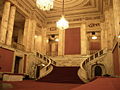
Current listings
| Landmark name | Image | Date listed | Location | Summary | |
|---|---|---|---|---|---|
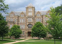
| 1 | Adelbert Hall, Case Western Reserve University Adelbert Hall Adelbert Hall is an administration building at Case Western Reserve University in Cleveland, Ohio and a registered historic building, listed in the National Register on 1973-10-30. It was built in 1881 to serve as the home of Western Reserve College and named after Adelbert Stone, the son of... |
 |
Case Western Reserve University Case Western Reserve University Case Western Reserve University is a private research university located in Cleveland, Ohio, USA... campus 41°30′18"N 81°36′30"W |
An administration building at Case Western Reserve University Case Western Reserve University Case Western Reserve University is a private research university located in Cleveland, Ohio, USA... , built in 1881 to serve as the home of Western Reserve College and named after Adelbert Stone, the son of industrialist Amasa Stone Amasa Stone Amasa Stone was an American industrialist who built railroads and invested in mills in Ohio. He was a major benefactor of Western Reserve College, which became part of Case Western Reserve University in 1967. Amasa Stone Chapel was built after his death in his memory... . The building was gutted by a fire in June 1991, and restoration of the building was completed in 1993. |
|
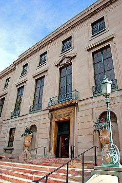
| 2 | Allen Memorial Medical Library Allen Memorial Medical Library Allen Memorial Medical Library is located along Euclid Avenue on the campus of Case Western Reserve University in Cleveland, Ohio. The library was designed in a classical revival style by the Cleveland firm of Walker and Weeks and completed in 1926. In addition to housing a portion of the Cleveland... |
 |
11000 Euclid Ave. 41°30′22"N 81°36′31"W |
Case Western Reserve University Case Western Reserve University Case Western Reserve University is a private research university located in Cleveland, Ohio, USA... building on Euclid Avenue, designed in a classical revival Neoclassical architecture Neoclassical architecture was an architectural style produced by the neoclassical movement that began in the mid-18th century, manifested both in its details as a reaction against the Rococo style of naturalistic ornament, and in its architectural formulas as an outgrowth of some classicizing... style by the Cleveland firm of Walker and Weeks Walker and Weeks Walker and Weeks was an architecture firm based in Cleveland, Ohio founded by Frank Ray Walker and Harry F. Weeks .-Background:... and completed in 1926. |
|
| 3 | Alta Public Library Alta Public Library Alta Public Library is a registered historic building in Cleveland, Ohio, listed in the National Register on 2005-10-04.... |
12510 Mayfield Rd. 41°30′29"N 81°35′46"W |
|||
| 4 | Ansel Road Apartment Buildings Historic District | 1588 Ansel Rd to 9501 Wade Park Ave. 41°30′52.61"N 81°37′11.86"W |
|||
| 5 | Archwood Avenue Historic District Archwood Avenue Historic District *****Archwood Avenue Historic District is a registered historic district in Cleveland, Ohio, listed in the National Register on 1987-03-19. It contains 57 contributing buildings.... |
Archwood Ave. roughly bounded by W. 31st Pl. and W. 37th St. 41°27′10"N 81°42′25"W |
|||
| 6 | Archwood Congregational Church Archwood Congregational Church Archwood Congregational Church is a registered historic building in Cleveland, Ohio, listed in the National Register on 1994-05-13.- External links :*... |
2800 Archwood Ave. 41°27′11"N 81°42′11"W |
|||
| 7 | Baker Motor Vehicle Company Building | 7100-7122 Euclid Ave. 41°30′14"N 81°38′21"W |
|||
| 8 | Beehive School | 4345 Lee Rd. 41°26′6.29"N 81°33′53.1"W |
Demolished. | ||
| 9 | Dr. James Bell House | 1822 E. 89th St. 41°30′57"N 81°37′28"W |
|||
| 10 | Sarah Benedict House | 3751 Prospect Ave. 41°30′8"N 81°39′41"W |
|||
| 11 | Bingham Company Warehouse | 1278 W. 9th St. 41°29′56"N 81°42′5"W |
|||
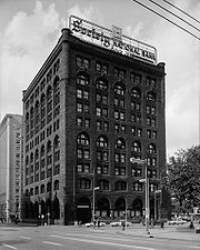
| 12 | H. Black and Company Building | 1900-2000 or 2010 Superior Ave. 41°30′24"N 81°40′45"W |
|||
| 13 | Body Block | 4925-4955 Payne Ave., 1692-1696 E. 55th St. 41°30′46"N 81°39′9"W |
|||
| 14 | Bohemian National Hall Bohemian National Hall (Cleveland, Ohio) Bohemian National Hall is an historic building located in Cleveland, Ohio that was built in 1896. It was listed on the National Register of Historic Places on May 28, 1975... |
4939 Broadway St. 41°28′20"N 81°39′23"W |
|||
| 15 | Bomante House | 3000 Mapledale Ave. 41°27′14"N 81°42′7"W |
|||
| 16 | Broadway Avenue Historic District | Broadway and Hamlet Aves. and E. 55th St. 41°28′1"N 81°39′2"W |
|||
| 17 | Brooklyn Bank Building | 3764 W. 25th St. 41°27′8"N 81°42′7"W |
|||
| 18 | Brooklyn Centre Historic District | Roughly bounded by Interstate 71 Interstate 71 Interstate 71 is an Interstate Highway in the Great Lakes/Midwestern and Southeastern region of the United States. Its southern terminus is at an interchange with Interstate 64 and Interstate 65 in Louisville, Kentucky. Its northern terminus is at an interchange with Interstate 90 in Cleveland,... , Pearl Rd., and Big Creek Valley 41°27′5"N 81°42′31"W |
|||
| 19 | Brownell School and Annex | 1300-1360 Sumner St. 41°29′52"N 81°40′49"W |
|||
| 20 | Caxton Building | 812 Huron Rd., SE. 41°29′54"N 81°41′10"W |
|||
| 21 | Cedar Glen Apartments | 11424-11432 Cedar Glen Parkway 41°29′58"N 81°36′16"W |
|||
| 22 | Central YMCA Central YMCA (Cleveland, Ohio) The Central YMCA is an historic building in the Central neighborhood on the east side of Cleveland, Ohio. Constructed for use as a residential building in 1911 by the Young Men's Christian Association of Greater Cleveland the building served as one of the locations used by the Cleveland ... |
2200 Prospect Ave. 41°29′59"N 81°40′26"W |
|||
| 23 | Cermak Building | 3503 E. 93rd St. 41°27′48"N 81°37′16"W |
|||
| 24 | Cleveland Arcade Cleveland Arcade The Arcade in downtown Cleveland, Ohio, is a Victorian-era structure of two nine-story buildings, joined by a five-story arcade with a glass skylight spanning over 300 feet , along the four balconies.... |
401 Euclid Ave. 41°29′58"N 81°41′36"W |
|||
| 25 | Cleveland Club | 10660 Carnegie Ave. 41°30′2"N 81°36′47"W |
|||
| 26 | Cleveland Dental Manufacturing Company Building | 3307 Scranton Rd. 41°27′48"N 81°41′54"W |
|||
| 27 | Cleveland Discount Building Superior Building The Superior Building, originally known as the Cleveland Discount Building, is a high-rise building in Cleveland, Ohio. The building rises 265 feet in Downtown Cleveland. It contains 22 floors, and was completed in 1922. The Superior Building currently stands as the 26th-tallest building in the... |
815 Superior Ave., NE. 41°30′10"N 81°41′24"W |
|||
| 28 | Cleveland East Pierhead Light | Eastern breakwater pierhead, entrance to Cleveland harbor 41°30′37"N 81°42′55"W |
|||
| 29 | Cleveland Grays Armory | 1234 Bolivar Rd. 41°29′56"N 81°40′56"W |
|||
| 30 | Cleveland Harbor Station, U.S. Coast Guard | New West Pier 41°30′11"N 81°42′46"W |
|||
| 31 | Cleveland Home for Aged Colored People Cleveland Home for Aged Colored People The former Cleveland Home For Aged Colored People located at 4807 Cedar Avenue in Cleveland, Ohio, is an historic building built in the early 1900s as a residential facility for elderly black people.... |
4807 Cedar Ave. 41°30′2"N 81°39′14"W |
|||
| 32 | Cleveland Mall The Mall (Cleveland) The Cleveland Mall is a long public park in downtown Cleveland, Ohio. It was conceived as part of the 1903 Group Plan by Daniel Burnham, John Carrère, and Arnold Brunner as a vast public space flanked by the city's major civic and governmental buildings, all built in the neoclassical style... |
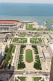 |
Roughly T-shaped mall area between E. 9th and W. 3rd Sts. 41°30′14"N 81°41′36"W |
||
| 33 | Cleveland Masonic Temple Cleveland Masonic Temple The Cleveland Masonic Temple in Cleveland, Ohio is a building from 1918. It contains 2 large organs . It was designed by Hubbell and Benes, architects. It was listed on the National Register of Historic Places in 2001.... |
3615 Euclid Ave. 41°30′13"N 81°39′44"W |
|||
| 34 | Cleveland Municipal Stadium Cleveland Stadium Cleveland Stadium was a multi-purpose stadium, located in Cleveland, Ohio. In its final years, the stadium seated 74,438, for baseball and 81,000, for football. It was one of the early multi-purpose stadiums, built to accommodate both baseball and football... |
Erieview Dr. 41°30′24"N 81°41′50"W |
Demolished in 1996 | ||
| 35 | Cleveland Packard Building | 5100-5206 Prospect Ave. 41°30′9"N 81°39′11"W |
|||
| 36 | Cleveland Public Square Public Square Public Square is the central plaza in downtown Cleveland, Ohio, United States. It takes up four city blocks; Superior Avenue and Ontario Street cross through it. Cleveland's three tallest buildings, Key Tower, 200 Public Square and the Terminal Tower, face the square... |
 |
Superior Ave. and Ontario St. 41°29′59"N 81°41′38"W |
||
| 37 | Cleveland Trust Company | 900 Euclid Ave. at E. 9th St. 41°30′0"N 81°41′9"W |
|||
| 38 | Cleveland Warehouse District | 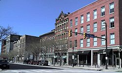 |
Roughly bounded by Front and Superior Aves. and Railroad, Summit, 3rd, and 10th Sts.; also 1384-1410 W. 10th St. 41°30′0"N 81°42′3"W |
10th St. addresses represent a boundary increase | |
| 39 | Cleveland West Pierhead Light | Cleveland Harbor on Lake Erie Lake Erie Lake Erie is the fourth largest lake of the five Great Lakes in North America, and the tenth largest globally. It is the southernmost, shallowest, and smallest by volume of the Great Lakes and therefore also has the shortest average water residence time. It is bounded on the north by the... 41°30′32"N 81°43′4"W |
|||
| 40 | Cleveland Worsted Mills Company | 5846-6116 Broadway 41°27′51"N 81°38′56"W |
Destroyed by fire, July 4, 1993. | ||
| 41 | Clinton Apartments | 3607 Clinton Ave. 41°29′13"N 81°42′50"W |
|||
| 42 | Colonial and Euclid Arcades | 508 and 600 Euclid Ave. 41°29′56"N 81°41′21"W |
|||
| 43 | Cook Building | 4600-4800 Prospect Ave. 41°30′8"N 81°39′18"W |
|||
| 44 | Corlett Building | 1923-35 Euclid Ave. 41°30′5"N 81°40′41"W |
|||
| 45 | The Courtland | 5403 Detroit Ave. 41°29′7"N 81°43′28"W |
|||
| 46 | Justus L. Cozad House | 11508 Mayfield Rd. 41°30′29"N 81°36′11"W |
|||
| 47 | Crawford-Tilden Apartments | 1831-1843 Crawford Rd. and 1878-1888 E. 84th St. 41°30′25"N 81°37′45"W |
The structure, built in 1908, is notable partially because of the way it is situated on a triangular piece of land, not unlike the Flatiron Building Flatiron Building The Flatiron Building, or Fuller Building, as it was originally called, is located at 175 Fifth Avenue in the borough of Manhattan, New York City and is considered to be a groundbreaking skyscraper. Upon completion in 1902 it was one of the tallest buildings in the city and the only skyscraper... . |
||
| 48 | Andrew Dall, Jr., and James Dall Houses | 2225 and 2229 E. 46th St. 41°29′52"N 81°39′14"W |
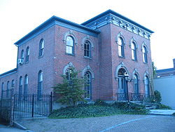
|||
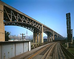
| 49 | Detroit-Superior High Level Bridge | 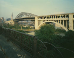 |
Over the Cuyahoga River Cuyahoga River The Cuyahoga River is located in Northeast Ohio in the United States. Outside of Ohio, the river is most famous for being "the river that caught fire", helping to spur the environmental movement in the late 1960s... valley between Detroit Ave. and Superior Ave. 41°29′39"N 81°42′9"W |
||
| 50 | Division Avenue Pumping Station | Division Ave., at the foot of W. 45th St. 41°29′24"N 81°43′0"W |
|||
| 51 | Dixon Hall Apartments | 3814 Prospect Ave. 41°30′6"N 81°39′36"W |
|||
| 52 | Doan School | 1350 E. 105th St. 41°31′13"N 81°36′58"W |
|||
| 53 | Dunham Tavern Dunham Tavern The Dunham Tavern, located at 6709 Euclid Avenue, is the oldest building in Cleveland, Ohio. Rufus and Jane Pratt Dunham built their first home on the site in 1824, and the existing taproom was built in 1842. It is believed to be the first building constructed on Euclid Avenue east of East 55th... |
6709 Euclid Ave. 41°30′17"N 81°38′19"W |
|||
| 54 | East 89th Street Historic District | E. 89th St. roughly between Chester and Hough Aves. 41°30′30"N 81°37′31"W |
|||
| 55 | East Boulevard Historic District | Roughly bounded by East Boulevard, St. Clair Ave., E. 99th St. and University Cir. 41°31′27"N 81°37′16"W |
|||
| 56 | East Fourth Street Historic District | Roughly on E. 4th St. between Euclid and Prospect Aves. 41°29′57"N 81°41′24"W |
|||
| 57 | East Ohio Gas Company Building | 1403 E. 6th St. 41°30′9"N 81°41′29"W |
|||
| 58 | Jeremiah Ensworth House | 3214 Prospect Ave. 41°30′4"N 81°39′50"W |
|||
| 59 | Erie Railroad Cleveland Powerhouse | 1246 River Rd. 41°29′47"N 81°42′42"W |
|||
| 60 | Euclid Avenue Historic District Euclid Avenue Historic District (Cleveland, Ohio) The Euclid Avenue Historic District is a historic district in downtown Cleveland, Ohio, United States. Established and listed on the National Register of Historic Places in 2002, it comprises along Euclid Avenue and parallel streets from Public Square to East 21st Street... |
Roughly bounded by Public Square, Euclid Ave. to E. 17th St., and E. 21st St.; also 205 St. Clair Ave., 1370 Ontario St., and 1796-1808 E. 13th St. 41°30′2"N 81°41′12"W |
Second set of boundaries represents a boundary increase | ||
| 61 | Euclid Avenue Presbyterian Church | 11205 Euclid Ave. 41°30′30"N 81°36′27"W |
|||
| 62 | The Euclid-Seventy-First Street Building | 7002-7030 Euclid Ave. 41°30′15"N 81°38′25"W |
|||
| 63 | Fairhill Road Village Historic District | 12309-12511 Fairhill Rd. 41°29′36"N 81°35′47"W |
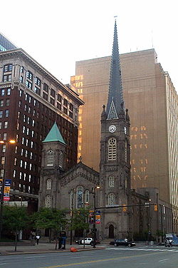
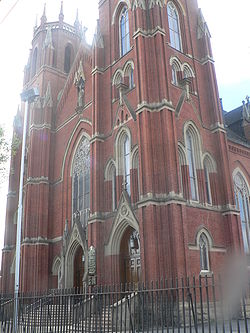
Extends into Cleveland Heights, elsewhere in Cuyahoga County | ||
| 64 | Federal Knitting Mills Building | 2860-2894 Detroit Ave.; also 2820 and 2811-21 Vermont Ave. 41°29′20"N 81°42′49"W |
Vermont Ave. addresses represent a boundary increase | ||
| 65 | Federal Reserve Bank of Cleveland Federal Reserve Bank of Cleveland The Federal Reserve Bank of Cleveland is the Cleveland-based headquarters of the U.S. Federal Reserve System's Fourth District. The district is composed of Ohio, western Pennsylvania, eastern Kentucky, and the northern panhandle of West Virginia. It has branch offices in Cincinnati and Pittsburgh.... |
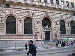 |
E. 6th St. and Superior Ave. 41°30′6"N 81°41′26"W |
||
| 66 | First Church of Christ, Scientist First Church of Christ, Scientist (Cleveland, Ohio) The former First Church of Christ, Scientist, located at 2200 Overlook Road, in the University Circle area of Cleveland, Ohio, in the United States is an historic building that was added to the National Register of Historic Places on February 20, 2003.... |
2200 Overlook Rd. 41°30′11"N 81°35′59"W |
|||
| 67 | First Methodist Church First Methodist Church (Cleveland, Ohio) First Methodist Church is a historic church in the Central neighborhood on the east side of Cleveland, Ohio.Located on the southeast corner of E.30th Street and Euclid Avenue, the church was built in 1905 and added to the National Register of Historic Places in 1995.-References:... |
3000 Euclid Ave. 41°30′8"N 81°40′1"W |
|||
| 68 | Ford Motor Company Cleveland Plant | .jpg) |
11610 Euclid Ave. 41°30′38"N 81°36′10"W |
||
| 69 | Forest City Bank Building | 1400 W. 25th St. 41°29′27"N 81°42′27"W |
|||
| 70 | Forest City Brewery | 6920-6922 Union Ave. 41°27′47"N 81°38′25"W |
|||
| 71 | Franklin Boulevard Historic District | Franklin Boulevard from W. 52nd to W. 38th Sts. 41°29′6"N 81°43′6"W |
|||
| 72 | Franklin Boulevard-West Clinton Avenue Historic District | 5207-7625 Franklin Boulevard and 5802-7325 W. Clinton Ave.; also 6801-7003 and 7319-7405 Detroit Ave. 41°28′57"N 81°43′49"W |
Detroit Ave. addresses represent a boundary increase | ||
| 73 | Phillip Gaensslen House Phillip Gaensslen House The Phillip Gaensslen House is a historic house in Cleveland, Ohio, United States, located at 3050 Prospect Avenue east of downtown. Built in about 1870, the Italianate house features a primarily brick exterior and a stone foundation. As suggested by its name, the house was constructed for... |
 |
3050 Prospect Ave. 41°30′3"N 81°39′58"W |
||
| 74 | Garfield Memorial | 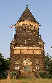 |
12316 Euclid Ave. in Lake View Cemetery Lake View Cemetery Lake View Cemetery is located on the east side of the City of Cleveland, Ohio, along the East Cleveland and Cleveland Heights borders. There are over 104,000 people buried at Lake View, with more than 700 burials each year. There are remaining for future development. Known locally as "Cleveland's... 41°30′36"N 81°35′29"W |
Extends into Cleveland Heights, elsewhere in Cuyahoga County | |
| 75 | Dr. William Gifford House Dr. William Gifford House The Dr. William Gifford House is a historic Tudor Revival house in Cleveland, Ohio, United States. Located east of downtown, the house sits in a neighborhood of historic houses and is a part of the Upper Prospect Multiple Resource Area. It was designed by Cleveland architect William W. Sabin and... |
 |
3047 Prospect Ave. 41°30′5"N 81°39′58"W |
||
| 76 | Francis K. Glidden House | 1901 Ford Dr. 41°30′40"N 81°36′30"W |
|||
| 77 | Globe Iron Works Building | 2320 Center St. 41°29′45"N 81°42′32"W |
|||
| 78 | Jacob Goldsmith House | 2200 E. 40th St. 41°29′53"N 81°39′26"W |
The structure was demolished in January, 1989, the result of arson damage the preceding November. | ||
| 79 | Gordon Square Building | 6500-6616 Detroit Ave. and 1396-1490 W. 65th St. 41°29′3"N 81°43′51"W |
|||
| 80 | Gordon Square Historic District | Detroit Ave. and W. 65th St. 41°29′2.59"N 81°43′48.99"W |
|||
| 81 | Greyhound Bus Station | 1465 Chester Ave. 41°30′12"N 81°40′56"W |
|||
| 82 | Halle Building | 1228 Euclid Ave. 41°30′0"N 81°40′59"W |
|||
| 83 | Halle's Shaker Square | 13000 Shaker Boulevard 41°29′0"N 81°35′32"W |
|||
| 84 | Harp Apartments | 1389 W. 64th St. 41°29′5"N 81°43′45"W |
|||
| 85 | Harvard School | 6900 Harvard Ave. 41°26′53"N 81°38′26"W |
|||
| 86 | Hay-McKinney and Bingham-Hanna House | 10825 E. Boulevard 41°30′48"N 81°36′38"W |
|||
| 87 | Hessler Court Wooden Pavement | 11330 East Boulevard between Bellflower and Hessler Rds. 41°30′39"N 81°36′20"W |
|||
| 88 | James Hill House | 1840 W. 58th St. 41°28′54"N 81°43′36"W |
|||
| 89 | Hilliard Apartment Building | 2804-2906 Sackett Ave. 41°27′49"N 81°42′6"W |
|||
| 90 | Holy Rosary Church Holy Rosary Church (Cleveland, Ohio) Holy Rosary Church is a historic Roman Catholic church in the Little Italy neighborhood of Cleveland, Ohio. It is the center of the annual Cleveland Feast of the Assumption Festival.... |
12021 Mayfield Rd. 41°30′32"N 81°35′56"W |
|||
| 91 | Hotel Statler | 1127 Euclid Ave. 41°30′2"N 81°41′6"W |
|||
| 92 | House of Wills | 2491 E. 55th St. 41°29′26"N 81°39′6"W |
|||
| 93 | Hoyt Block | 608 W. St. Clair St. 41°29′59"N 81°41′56"W |
|||
| 94 | Hruby Conservatory of Music | 5417 Broadway St. 41°28′5"N 81°39′7"W |
|||
| 95 | Joseph Ireland House | 2074 E. 36th St. 41°30′3"N 81°39′46"W |
Demolished. | ||
| 96 | Irishtown Bend Archeological District Irishtown Bend Archeological District The Irishtown Bend Archeological District is an historic site located in the old Irishtown Bend neighborhood of Cleveland, Ohio. To protect the site while it is being excavated, its exact location has not been made public.... |
 |
Western bank of the Cuyahoga River Cuyahoga River The Cuyahoga River is located in Northeast Ohio in the United States. Outside of Ohio, the river is most famous for being "the river that caught fire", helping to spur the environmental movement in the late 1960s... , along Riverbed Rd. 41°29′22.2"N 81°42′17.65"W |
||
| 97 | Jennings Apartments | 2711 W. 14th St. 41°28′30"N 81°41′29"W |
|||
| 98 | Jones Home for Children | 3518 W. 25th St. 41°27′30"N 81°42′6"W |
|||
| 99 | The Joseph and Feiss Clothcraft Shops | 2149 W. 53rd St. 41°28′24"N 81°43′18"W |
|||
| 100 | Karamu House Karamu House Karamu House in the Fairfax neighborhood on the east side of Cleveland, Ohio, is the oldest African-American theater in the United States. Many of Langston Hughes's plays were developed and premièred at the theater.-History:... |
2355 E. 89th St. 41°29′37"N 81°37′26"W |
|||
| 101 | Kennedy Apartments and Commercial Block | 6425 Detroit Ave. 41°29′2"N 81°43′48"W |
|||
| 102 | Lewis Kies House | 4208 Prospect Ave. 41°30′8"N 81°39′25"W |
|||
| 103 | W.H. Kindra Apartments | 3802-2812 Mapledale Ave. 41°27′15"N 81°42′36"W |
|||
| 104 | Krause Building-Otto Moser's Cafe | 2042-2044 E. 4th St. 41°29′56"N 81°41′27"W |
|||
| 105 | Theodor Kundtz Company Building | 2249 Elm St. 41°29′45"N 81°42′23"W |
|||
| 106 | LaSalle Theatre Building | 819-829 E. 185th St. 41°35′6"N 81°32′59"W |
|||
| 107 | League Park League Park League Park was a baseball park located in Cleveland, Ohio, United States. It was situated at the northeast corner of Lexington Avenue and E. 66th Street in the Hough neighborhood. It was home to the National League Cleveland Spiders, the American League Cleveland Indians, and the Cleveland... |
Lexington and 66th Sts. 41°30′42"N 81°38′39"W |
|||
| 108 | Lerner Building | 322-324 Euclid Ave. 41°30′2"N 81°41′31"W |
|||
| 109 | Lindner Building | 1331 Euclid Ave. 41°30′4"N 81°40′55"W |
|||
| 110 | Lorain Avenue Commercial Historic District | 3202-5730 Lorain Ave. 41°28′45"N 81°43′0"W |
|||
| 111 | Lorain Station Historic District | 9005-10134 Lorain Ave. 41°28′5"N 81°44′57"W |
|||
| 112 | Lorain-Carnegie Bridge Hope Memorial Bridge The Hope Memorial Bridge is a 5,865 foot long art deco truss bridge crossing the Cuyahoga River in Cleveland, Ohio. It stands 93 feet above the waterline in order to allow shipping to pass... |
 |
Spans the Cuyahoga River Cuyahoga River The Cuyahoga River is located in Northeast Ohio in the United States. Outside of Ohio, the river is most famous for being "the river that caught fire", helping to spur the environmental movement in the late 1960s... between Lorain and Carnegie Aves. 41°29′26"N 81°41′30"W |
||
| 113 | Lower Prospect-Huron Historic District | Seven blocks in downtown centered around the junction of Prospect Ave., Huron Rd. and E. 9th St.; also 727, 737, 1020-1060, and 1124 Bolivar Rd., 2217 E. 9th St., and 1303 Prospect Ave. 41°29′55"N 81°41′10"W |
Second set of boundaries represent a boundary increase | ||
| 114 | Magnolia-Wade Park Historic District | Roughly bounded by Asbury Ave., E. 118th St., Wade Park Ave., Mistletoe Dr., Magnolia Dr., and E. 105th St. 41°30′54"N 81°36′30"W |
|||
| 115 | Malio House | 3781 W. 25th St. 41°27′12"N 81°42′4"W |
|||
| 116 | Flora Stone Mather College District | Bellflower Rd. at Ford Dr. 41°30′32"N 81°36′28"W |
|||
| 117 | May Company May Company Ohio The May Company Ohio is a defunct chain of department stores that was based in Cleveland, Ohio, United States.-History:In 1899, David May, the founder of May Department Stores, acquired E. R. Hull & Dutton Co. of Cleveland on Ontario Street, renaming it May Company, Cleveland... |
158 Euclid Ave. at Public Sq. 41°29′55"N 81°41′31"W |
|||
| 118 | McKinley Terrace | 1406-1426 W. 81st St. 41°28′51"N 81°44′29"W |
|||
| 119 | Medical Centre Building | 1001 Huron Rd. 41°30′0"N 81°41′6"W |
|||
| 120 | George Merwin House | 3028 Prospect Ave. 41°30′6"N 81°39′52"W |
|||
| 121 | Miles Park Historic District | Miles Park Ave. around Miles Park 41°26′49"N 81°37′21"W |
|||
| 122 | Miller Block | 3202-3214 Lorain Ave. 41°28′56"N 81°42′32"W |
|||
| 123 | Montana Apartments | 2061 E. 36th St. 41°30′4"N 81°39′45"W |
Demolished prior to 2005. |
||
| 125 | Garrett Morgan House | 5202 Harlem Ave. 41°30′53"N 81°39′12"W |
Demolished | ||
| 126 | Murray Hill School | 2026 Murray Hill Rd. and 2043 Random Rd. 41°30′27"N 81°35′55"W |
|||
| 127 | National Town and Country Club Fenn Tower Fenn Tower is a 22-story skyscraper in Cleveland, Ohio. It is owned by Cleveland State University. It was built for the National Town and Country Club, but was only used for one event before closing. It was originally known as the National Town and Country Club before being sold. It was purchased... |
2401 Euclid Ave. 41°30′8"N 81°40′20"W |
|||
| 128 | Neff Apartments | 3606 Prospect Ave. 41°30′5"N 81°39′45"W |
Demolished prior to 2005; the photo is of the structure that replaced that building. | ||
| 129 | New England Building Guardian Bank Building The Guardian Bank Building, originally known as the New England Building and later known as the National City Bank Building, is a high-rise building on Euclid Avenue in downtown Cleveland, Ohio. It was built in 1896 and stands adjacent to National City Center. At tall, it was once one of the... |
617-637 Euclid Ave., 614-626 Vincent Ave. 41°30′1"N 81°41′20"W |
|||
| 130 | Newton Avenue Historic District | 9700-10003 Newton Ave. 41°30′41"N 81°37′7"W |
|||
| 131 | North Presbyterian Church North Presbyterian Church (Cleveland, Ohio) North Presbyterian Church is a historic church at 4001 Superior Avenue in Cleveland, Ohio.It was built in 1887 and added to the National Register in 1974.... |
4001 Superior Ave. 41°30′51"N 81°39′44"W |
|||
| 132 | Notre Dame Academy | 1325 Ansel Rd. 41°31′14"N 81°37′18"W |
|||
| 133 | Ohio Bell Henderson-Endicott Exchange Building | 5400-5420 Prospect Ave. 41°30′9"N 81°39′9"W |
|||
| 134 | Ohio City Preservation District | Bounded by W. 26th, Clinton, W. 38th, and Carroll Sts.; also roughly Franklin Boulevard NW., W. 38th St., Bridge Ave. NW., and W. 44th St., and Stone, W. 25th, Bridge Ave. NW., and W. 28th 41°29′7"N 81°42′33"W |
|||
| 135 | Old Federal Building and Post Office Howard M. Metzenbaum United States Courthouse The Howard M. Metzenbaum U.S. Courthouse is a historic courthouse and post office building located on Superior Avenue in downtown Cleveland, Cuyahoga County, Ohio. Its west side faces Public Square and its north side faces The Mall. It was formerly the Federal Building and U.S. Courthouse and also... |
201 Superior Ave., NE. 41°30′2.5"N 81°41′33.75"W |
|||
| 136 | Old River Road Historic District The Flats The Flats is a mixed-use industrial, entertainment, and increasingly residential area of Cleveland, Ohio, USA. The name reflects its low-lying topography on the banks of the Cuyahoga River.-History:... |
1220-1330 Old River Rd. 41°29′54"N 81°42′13"W |
|||
| 137 | Old Stone Church Old Stone Church (Cleveland, Ohio) The Old Stone Church is a historic Presbyterian church located in downtown Cleveland, Ohio, and is the oldest building on Public Square. It is also the second church built within the city limits.- History :... |
 |
91 Public Sq. 41°30′1"N 81°41′42"W |
||
| 138 | Charles Olney House and Gallery | 2241-2255 W. 14th St. 41°28′53"N 81°41′28"W |
|||
| 139 | Panek Block | 3154 E. 49th St. 41°28′22"N 81°39′29"W |
|||
| 140 | Park Building | 140 Public Sq. 41°29′24"N 81°41′0"W |
|||
| 141 | Peerless Motor Company Plant No. 1 | 9400 Quincy Ave. 41°29′33"N 81°37′16"W |
Demolished. | ||
| 142 | Pennsylvania Railway Ore Dock |  |
At Whiskey Island Whiskey Island (Cleveland) Whiskey Island is a peninsula at the mouth of the Cuyahoga River at Lake Erie in Cleveland, Ohio. Its current configuration was created in 1827 when the river's mouth was moved to its present location. The western half of Whiskey Island is occupied by the Cleveland Bulk Terminal and the eastern... 41°29′44"N 81°43′19"W |
Two of the four historic Hullet ore unloaders were scrapped in 2000, with the remaining two being dismantled for possible reassembly TBD. | |
| 143 | Perry-Payne Building | 740 Superior Ave. 41°29′57"N 81°41′54"W |
|||
| 144 | Pilgrim Congregational Church Pilgrim Congregational Church (Cleveland, Ohio) Pilgrim Congregational Church is a historic church at 2592 West 14th Street in Cleveland, Ohio.It was built in 1894 and added to the National Register in 1976.... |
2592 W. 14th St. 41°28′37"N 81°41′31"W |
|||
| 145 | Playhouse Square Group Playhouse Square Center The Playhouse Square Center, in downtown Cleveland, Ohio, is the second-largest theater complex in the United States . Constructed in a span of nineteen months in the early 1920s, the theaters were subsequently closed down, but were revived through a grass-roots effort... |
 |
2067 E. 14th St.; 1422, 1501, 1515, 1621 Euclid Ave. 41°30′3"N 81°40′51"W |
||
| 146 | Plaza Apartments | 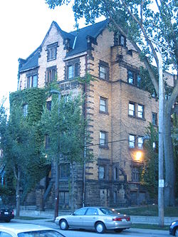 |
3206 Prospect Ave. 41°30′4"N 81°39′53"W |
||
| 147 | Prospect Avenue Row House Group | 3645, 3649, 3651, and 3657 Prospect Ave. 41°30′7"N 81°39′41"W |
|||
| 148 | Quad Hall | 7500 Euclid Ave. 41°30′17"N 81°38′11"W |
Demolished. | ||
| 149 | N.J. Rich and Co. Building | 1974 E. 61st St. 41°30′20"N 81°38′55"W |
|||
| 150 | Riverside Cemetery Building | 3607 W. 25th St. 41°27′21"N 81°42′1"W |
|||
| 151 | Riverside Cemetery Chapel Riverside Cemetery Chapel Riverside Cemetery Chapel is a historic chapel at 3607 Pearl Road in Cleveland, Ohio.It was built in 1876 and added to the National Register in 1987.... |
3607 Pearl Rd. 41°27′25"N 81°41′55"W |
|||
| 152 | Rockefeller Building | 614 Superior Ave. 41°29′53"N 81°41′51"W |
|||
| 153 | Rockefeller Park and Cleveland Cultural Gardens Historic District | Roughly bounded by Mt. Sinai Rd., East Boulevard, Conrail tracks, and Ansel Rd. 41°31′30"N 81°37′22"W |
|||
| 154 | Rockefeller Park Bridges | Rockefeller Park 41°31′41"N 81°37′34"W |
|||
| 155 | Root and McBride-Bradley Building | 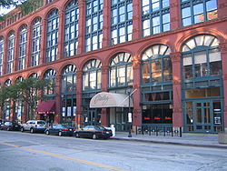 |
1220-1230 W. 6th St. 41°30′3"N 81°42′1"W |
||
| 156 | St. Elizabeth's Magyar Roman Catholic Church St. Elizabeth's Magyar Roman Catholic Church St. Elizabeth's Magyar Roman Catholic Church is a historic church at 9016 Buckeye Road in Cleveland, Ohio.It was built in 1918 and added to the National Register in 1976.-References:... |
9016 Buckeye Rd. 41°29′7"N 81°37′24"W |
|||
| 157 | St. Ignatius High School |  |
1911 W. 30th St. at Carroll Ave. 41°29′0"N 81°42′28"W |
||
| 158 | St. John's AME Church St. John's AME Church St. John's African Methodist Episcopal Church is a historic church at 2261 East 40th Street in Cleveland, Ohio.It was built in 1908 and added to the National Register in 1982.-References:... |
2261 E. 40th St. 41°29′48"N 81°39′22"W |
|||
| 159 | St. John's Episcopal Church St. John's Episcopal Church (Cleveland, Ohio) St. John's Episcopal Church is located at 2600 Church Street in the Ohio City neighborhood of Cleveland, Ohio. St. John's is the oldest consecrated building in Cuyahoga county. This stone gothic revival church building was designed by Hezekiah Eldredge and built beginning in 1836 and was completed... |
2600 Church St. 41°29′24"N 81°42′30"W |
|||
| 160 | St. Joseph's Church and Friary St. Joseph's Church and Friary St. Joseph's Church and Friary is a historic church at 2543 E. 23rd Street at Woodland in Cleveland, Ohio.It was designed by architects Cudell & Richardson, built in 1873, and added to the National Register in 1976.-References:... |
2543 E. 23rd St. at Woodland 41°29′35"N 81°40′22"W |
Demolished. | ||
| 161 | St. Luke's Hospital St. Luke's Hospital (Cleveland, Ohio) St. Luke's Hospital is a historic former hospital at 11311 Shaker Boulevard in Cleveland, Ohio.The hospital building was constructed in 1927 and added to the National Register of Historic Places in 2005.-References:... |
11311 Shaker Boulevard 41°29′6"N 81°36′21"W |
|||
| 162 | St. Michael the Archangel Catholic Church St. Michael the Archangel Church St. Michael the Archangel is a Roman Catholic church located at 3114 Scranton Road in the Clark-Fulton neighborhood on the west side of Cleveland, Ohio. The church is named in honor of St. Michael the Archangel and was completed in 1892.... |
 |
3114 Scranton Rd. 41°28′11"N 81°41′50"W |
||
| 163 | St. Paul's Episcopal Church St. Paul's Episcopal Church (Cleveland, Ohio) St. Paul's Episcopal Church is a historic church at 4120 Euclid Avenue in Cleveland, Ohio.It was built in 1876 and added to the National Register of Historic Places in 1980.-References:... |
4120 Euclid Ave. 41°30′12"N 81°39′28"W |
|||
| 164 | St. Stanislaus Church St. Stanislaus Church (Cleveland, Ohio) St. Stanislaus Church was established in 1873 by Polish American immigrants from Poland. They established a church and school for the growing Pol-Am or Polish American Community of Cleveland. The Alliance of Poles on Broadway Avenue was allied with the St. Stanislaus Parish Community. As St.... |
 |
Forman and E. 65th Sts. 41°27′33"N 81°38′41"W |
||
| 165 | St. Stephen Church | 1930 W. 54th St. 41°28′44"N 81°43′27"W |
|||
| 166 | St. Theodosius Russian Orthodox Cathedral St. Theodosius Russian Orthodox Cathedral St. Theodosius Russian Orthodox Cathedral is a Russian Orthodox parish located on Starkweather Avenue in the Tremont neighborhood, on the near West Side of Cleveland, Ohio. It is listed on the National Register of Historic Places.St... |
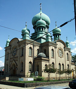 |
733 Starkweather Ave. 41°28′38"N 81°40′54"W |
||
| 167 | Charles Schweinfurth House | 1915 E. 75th St. 41°30′18"N 81°38′10"W |
|||
| 168 | Shaker Square Shaker Square Buckeye-Shaker is a neighborhood on the East Side of Cleveland, Ohio. It encompasses the old Buckeye neighborhood and Shaker Square neighborhood, the latter of which is centered around an historic shopping district and an eponymous rapid transit station, located at the intersection of Shaker and... |
 |
Shaker and Moreland Boulevards 41°29′2"N 81°35′26"W |
||
| 169 | Shaker Village Historic District Shaker Village Historic District (Shaker Heights, Ohio) Shaker Village Historic District is a historic district between Fairmount and Lomond Boulevards, and Green, Warrensville Center, Becket, and Coventry Roads in Shaker Heights, Ohio. The district comprises roughly seventy percent of the city of Shaker Heights.... |
 |
Roughly bounded by Fairmount and Lomond Boulevards and Green, Warrensville Center, Becket, and Coventry Rds.; also roughly bounded by Lomond Boulevard, Lytel Rd., Scottsdale Boulevard, and Lindholm Rd. 41°28′33"N 81°33′11"W |
Extends into Cleveland Heights and Shaker Heights, elsewhere in Cuyahoga County |
|
| 171 | Society for Savings Building Society for Savings Building The Society for Savings Building, also known as the Society Corp. Building, is a high-rise building on Public Square in downtown Cleveland, Ohio, United States. The building was constructed in 1889, and stood as the tallest building in Cleveland until 1896, when it was surpassed by the 221-foot ... |
 |
Public Sq. 41°30′2"N 81°41′40"W |
||
| 172 | South Brooklyn Commercial District | Roughly along Pearl and Broadview Rds. 41°26′36"N 81°42′16"W |
|||
| 173 | Southworth House Southworth House (Cleveland, Ohio) The Southworth House is a Classical Revival and Italianate house in Cleveland, Ohio, United States that was built in 1879. Named for its first owner, W.P. Southworth, a leading resident of late nineteenth-century Cleveland, the house has been used for a variety of commercial purposes in recent... |
3334 Prospect Ave. 41°30′4"N 81°39′48"W |
|||
| 174 | Stager-Beckwith House | 3813 Euclid Ave. 41°30′14"N 81°39′35"W |
|||
| 175 | Stanley Block | 2115-2121 Ontario St. 41°29′52"N 81°41′29"W |
Lower Prospect-Huron District MPS | ||
| 176 | Stockbridge Apartment Building | 3328 Euclid Ave. 41°30′10"N 81°39′41"W |
|||
| 177 | Superior Avenue Historic District | 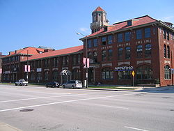 |
1860-2553 Superior Ave. 41°30′28.8"N 81°40′37.2"W |
||
| 178 | Superior Avenue Viaduct | Superior Ave. 41°29′41"N 81°42′16"W |
|||
| 179 | Tavern Club Tavern Club (Cleveland, Ohio) The Tavern Club is private social club in the Central neighborhood of Cleveland, Ohio, USA. Its home is a building designed by architect J. Milton Dyer in a Northern Renaissance style. It was listed on the National Register of Historic Places in 1984. It was also designated as a landmark by the... |
3522 Prospect Ave. 41°30′4"N 81°39′47"W |
|||
| 180 | Templar-Farrell Motor Sales Building | 3134 Prospect Ave. 41°30′4"N 81°39′55"W |
|||
| 181 | The Temple The Temple (Cleveland, Ohio) The Temple built in 1924 is a historic synagogue building located on University Circle at Silver Park in Cleveland, Ohio. In 1963, a branch synagogue, Tifereth-Israel, was established in suburban Beachwood, which is now the main place of worship... |
University Circle at Silver Park 41°30′29"N 81°36′58"W |
|||
| 182 | Third Church of Christ, Scientist Third Church of Christ, Scientist (Cleveland, Ohio) The former Third Church of Christ, Scientist built in 1906 is an historic Christian Science church building located at 3648 West 25th Street in Cleveland, Ohio, It was designed in the Classical Revival style by noted Cleveland architect Frederick N. Striebinger.On March 19, 1987, it was added to... |
3648 W. 25th St. 41°27′17"N 81°42′6"W |
|||
| 183 | Hannes Tiedemann House Franklin Castle Franklin Castle is a historical house located at 4308 Franklin Boulevard in Cleveland's Ohio City neighborhood. The building has four stories and more than twenty rooms... |
4308 Franklin Boulevard 41°29′8"N 81°42′59"W |
|||
| 184 | Clayton Townes House | 3800 W. 33rd St. 41°27′6"N 81°42′19"W |
|||
| 185 | Tremont Historic District | Roughly bounded by Interstate 490 Interstate 490 (Ohio) Interstate 490 is a Interstate Highway in Cleveland, Ohio. The western terminus is a junction with I-90 and I-71 on Cleveland's west side. After spanning the Cuyahoga River, the eastern terminus is a junction with East 55th Street, just east of I-77.... , Interstate 71 Interstate 71 Interstate 71 is an Interstate Highway in the Great Lakes/Midwestern and Southeastern region of the United States. Its southern terminus is at an interchange with Interstate 64 and Interstate 65 in Louisville, Kentucky. Its northern terminus is at an interchange with Interstate 90 in Cleveland,... , University Ct., W. 7th St., Starkweather Ave., Brayton, Fruit Ave. and Auburn Ave. 41°28′45"N 81°41′16"W |
|||
| 186 | Trinity Cathedral Trinity Cathedral (Cleveland, Ohio) Trinity Cathedral is a historic church on Euclid Avenue at East 22nd Street in Cleveland, Ohio. It is the cathedral of the Episcopal Diocese of Ohio.It was built in 1901 and added to the National Register of Historic Places in 1973.-External links:... |
Euclid Ave. at E. 22nd St. 41°30′4"N 81°40′28"W |
|||
| 187 | Trinity Cathedral Church Home | 2227 Prospect Ave. 41°30′2"N 81°40′27"W |
|||
| 188 | Union Club | 1211 Euclid Ave. 41°30′12"N 81°41′4"W |
|||
| 189 | Union Steel Screw Office Building | 1675-7 E. 40th St. 41°30′50"N 81°39′34"W |
|||
| 190 | Union Terminal Group Tower City Center Tower City Center is a large mixed-use facility located on Public Square in downtown Cleveland, Ohio. The facility is composed of a number of interconnected office buildings, including the landmark Terminal Tower, a shopping mall, two hotels, and the main hub of Cleveland's three rapid transit lines... |
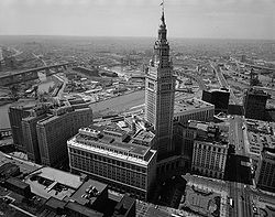 |
Public Sq. 41°29′52"N 81°41′39"W |
||
| 191 | United Motor Service Building | 4019 Prospect Ave. 41°30′9"N 81°39′25"W |
|||
| 192 | Universal Terminal Company Dock and Warehouse | 5451 N. Marginal Rd. 41°31′48"N 81°39′20"W |
|||
| 193 | University Hall, Cleveland State University | 2605 Euclid Ave. 41°30′11"N 81°40′14"W |
|||
| 194 | Upson-Walton Company Building | 1310 Old River Rd. (W. 11th St.) 41°29′53"N 81°42′10"W |
|||
| 195 | USS COD (submarine) | 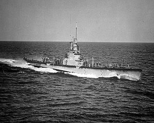 |
N. Marginal Dr. 41°30′37"N 81°41′32"W |
||
| 196 | Van Rooy Coffee Company Building | 2900 Detroit Ave. 41°29′23"N 81°42′41"W |
|||
| 197 | Variety Store Building and Theatre | 11801-11825 Lorain Ave. 41°27′40"N 81°46′14"W |
|||
| 198 | Venice Building | 8401-8417 Euclid Ave. 41°30′14"N 81°37′43"W |
Demolished prior to 2003. | ||
| 199 | Vitrolite Building | 2911-2915 Detroit Ave. 41°29′22"N 81°42′42"W |
|||
| 200 | Wade Memorial Chapel Wade Memorial Chapel The Wade Memorial Chapel is a historic chapel in Cleveland, Ohio, United States. The Neoclassical chapel was built in 1901 in Cleveland's Lake View Cemetery, which is the location of over 104,000 burials. It was listed on the National Register of Historic Places in 1973... |
12316 Euclid Ave. inside Lakeview Cemetery 41°30′49"N 81°35′42"W |
|||
| 201 | Wade Park District Wade Park District The Wade Park District is an historic district on the National Register of Historic Places, located in the University Circle neighborhood on the east side of Cleveland, Ohio. The district, which covers roughly 650 acres, is bounded by Chester Avenue and Euclid Avenue on the south, East Boulevard... |
Roughly bounded by E. 105th St., East Boulevard, and Chester and Euclid Aves. 41°30′30"N 81°36′46"W |
|||
| 202 | Walker and Weeks Office Building | 2341 Carnegie Ave. 41°29′58"N 81°40′21"W |
|||
| 203 | Warszawa Neighborhood District Slavic Village South Broadway is a neighborhood on the southeast side of Cleveland, Ohio. One of the city's oldest neighborhoods, much of the area has historically served as home to Cleveland's original Czech and Polish immigrants... |
E. 65th St. and Forman Ave. 41°27′29"N 81°38′41"W |
|||
| 204 | Waterman Service Building | 3030 E. 63rd St. 41°30′11"N 81°38′51"W |
|||
| 205 | Watterson School | 1422 W. 74th St. 41°28′55"N 81°44′16"W |
|||
| 206 | Weizer Building Weizer Building (8935 Buckeye Road, Cleveland, Ohio) The Weizer Building was a historic commercial structure located at 8935 Buckeye Road in Cleveland, Ohio, United States. Designed by Emile Uhlrich, it was constructed in 1913. It was listed on the National Register of Historic Places in 1988, but it was destroyed by 2007.... |
8935 Buckeye Rd. 41°29′7"N 81°37′25"W |
Demolished | ||
| 207 | Weizer Building Weizer Building (11801 Buckeye Road, Cleveland, Ohio) The Weizer Building at 11801 Buckeye Rd. in Cleveland, Ohio was built in 1925. It was listed on the National Register of Historic Places in 2002. It is a Beaux Arts style building.... |
11801 Buckeye Rd. 41°28′52"N 81°36′2"W |
|||
| 208 | West Side Market West Side Market The West Side Market is the oldest operating indoor/outdoor market space in Cleveland, Ohio. It is located at the corner of West 25th Street and Lorain Avenue in the Ohio City district. On December 18, 1973, it was added to the National Register of Historic Places.-History:The market began... |
 |
W. 24th St. and Lorain Ave. 41°29′4"N 81°42′11"W |
||
| 209 | West Technical High School | 2201 W. 93rd St. 41°28′19"N 81°44′48"W |
|||
| 210 | Western Reserve Building | 1468 W. 9th St. 41°29′50"N 81°41′59"W |
|||
| 211 | Phillis Wheatley Association | 4450 Cedar Ave. 41°30′0"N 81°39′18"W |
|||
| 212 | White Chewing Gum Company Building | 10307 Detroit Ave. 41°28′49"N 81°45′26"W |
|||
| 213 | Henry P. White House | Northwestern corner of Euclid Ave. and E. 90th St. 41°30′14"N 81°37′23"W |
|||
| 214 | Woodland Avenue and West Side Railroad Powerhouse | 1180 Cathan Ave., NW 41°29′47"N 81°42′13"W |
|||
| 215 | Woodland Cemetery | 6901 Woodland Ave. 41°28′54"N 81°38′30"W |
|||
| 216 | Zero Gravity Research Facility (B-2) | 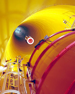 |
Lewis Research Center 41°24′44"N 81°51′51"W |
||
| 217 | Zion Lutheran Church Zion Lutheran Church (Cleveland, Ohio) Zion Lutheran Church is a historic church at East 30th Street and Prospect Ave in the Central neighborhood on the east side of Cleveland, Ohio.It was built in 1902 and added to the National Register of Historic Places in 1984.... |
2062 E. 30th St. 41°30′2"N 81°40′3"W |
|||
| 218 | Zion Lutheran School | 2074 E. 30th St. 41°30′1"N 81°40′2"W |
Former listing
| Landmark name | Image | Date delisted | Location | Summary | |
|---|---|---|---|---|---|
| 1 | McDonald's Drive-in | 988 E. 152nd St. 41°33′5.6"N 81°34′32.4"W |
Listed on |
See also
- List of National Historic Landmarks in Ohio
- National Register of Historic Places listings in Ohio
External links
- Cleveland Landmarks, as designated by the Cleveland Landmarks Commission