
Irishtown Bend Archeological District
Encyclopedia
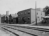
The Irishtown Bend Archeological District is an historic site located in the old Irishtown Bend
neighborhood of Cleveland
, Ohio
. To protect the site while it is being excavated, its exact location has not been made public.
In the second half of the 19th century, this river flats district
was a distinctly Irish neighborhood. The wealth of historical data available for this neighborhood, including census records, tax archives, city directories, church records and archeological evidence, provides an unusual opportunity to develop a comprehensive picture of this community. First generation Irish-immigrant laborers lived here from the 1850s through the 1880s. Beginning in the 1820s, Irish immigrants moved to the Ohio City area and were initially employed digging the Ohio and Erie Canal. Malaria was common at the time, but drainage was improved during the 1830s as Cleveland evolved into a major lake shipping port. The 1830s and 1840s brought continued prosperity to the port of Cleveland, but communicable diseases such as cholera were widespread in the low-lying Flats. As a result, low cost land was available for housing the workers who walked to the jobs on the docks.
As the second generation of Irish families obtained better-paying work, and dock work was increasingly mechanized, the Irish began moving out of the Flats. By 1900, more than half of this area's residents were of Eastern European origin, although the Irish families still owned many of the properties. Irishtown Bend was gradually abandoned; by 1910, more than a third of the homes had been torn down. In 1952, only five of the original 80 buildings were left standing.
Between 1987 and 1989, the Department of Archaeology at the Cleveland Museum of Natural History began excavations by performing test digs on three properties in the district. The histories of the three families: Connor, Connley and Quinn were determined through numerous sources, and the artifacts from the sites revealed the economic status of each family. The family that was best off financially had a piece of fine porcelain as well as a large set of dishes of the same pattern. They also ate chickens and drank more tea than their poorer neighbors. The poorest family's site yielded dishes of many different patterns (indicating they were purchased or gained one at-a-time rather than as a more expensive set) with many soup bowls, and cheap cuts of stew meat were predominant in their diet. Poor families did not eat their chickens - they sold the eggs that the chickens produced. The study also showed that debris piles associated with these Irish households suggest a lower rate of alcohol consumption than the average Cleveland household of the same period.
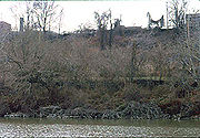
Today this area remains free of development and well preserved due to the area's soil type, shale bedrock and thick cover of vegetation. Although the buildings are no longer standing, and their remains covered over with demolition debris, substantial data can still be retrieved from the area illustrating life as it existed in the 19th century.
Irishtown Bend Archeological District is located along Riverbed Road and the west bank of the Cuyahoga River
in Cleveland, Ohio
. It is not open to the public, but can be seen from Riverbed Rd.
 As the Irish of Cleveland began to join the middle class, they left Irishtown Bend and headed for the western suburbs of Lakewood
, Fairview Park
and West Park
(now a neighborhood of Cleveland). Many of the houses they left behind were briefly inhabited by Hungarian immigrants
, then abandoned again. Most of the structures were demolished; only a handful remain.
Between 1987 and 1989, an archeology team led by Al Lee of the Cleveland Museum of Natural History
began to excavate the area, finding ceramics and personal effects with a distinct Irish flavor.
The area was added to the National Register of Historic Places
on May 25, 1990.
Irishtown Bend
Irishtown Bend is an area of Cleveland, Ohio, USA located along the Cuyahoga River in the Flats. It encompassed roughly the area from West 25th Street east to the river north of Detroit Road. The swampy area was developed during the 1830s by immigrant Irish who came to the area as laborers for the...
neighborhood of Cleveland
Cleveland, Ohio
Cleveland is a city in the U.S. state of Ohio and is the county seat of Cuyahoga County, the most populous county in the state. The city is located in northeastern Ohio on the southern shore of Lake Erie, approximately west of the Pennsylvania border...
, Ohio
Ohio
Ohio is a Midwestern state in the United States. The 34th largest state by area in the U.S.,it is the 7th‑most populous with over 11.5 million residents, containing several major American cities and seven metropolitan areas with populations of 500,000 or more.The state's capital is Columbus...
. To protect the site while it is being excavated, its exact location has not been made public.
In the second half of the 19th century, this river flats district
The Flats
The Flats is a mixed-use industrial, entertainment, and increasingly residential area of Cleveland, Ohio, USA. The name reflects its low-lying topography on the banks of the Cuyahoga River.-History:...
was a distinctly Irish neighborhood. The wealth of historical data available for this neighborhood, including census records, tax archives, city directories, church records and archeological evidence, provides an unusual opportunity to develop a comprehensive picture of this community. First generation Irish-immigrant laborers lived here from the 1850s through the 1880s. Beginning in the 1820s, Irish immigrants moved to the Ohio City area and were initially employed digging the Ohio and Erie Canal. Malaria was common at the time, but drainage was improved during the 1830s as Cleveland evolved into a major lake shipping port. The 1830s and 1840s brought continued prosperity to the port of Cleveland, but communicable diseases such as cholera were widespread in the low-lying Flats. As a result, low cost land was available for housing the workers who walked to the jobs on the docks.
Ohio and Erie Canal National Heritage Corridor
The number of Irish immigrants increased after the 1848 Irish potato famine, and many worked as unskilled laborers and dockworkers, and on the excavation of a new channel and mouth for the Cuyahoga River. In the 1850s, the area of Irishtown Bend 41°29′22.2"N 81°42′17.65"W was established and dominated by the winding Cuyahoga River with its swampy flood plain. Houses were primarily one or two stories and built of wood.As the second generation of Irish families obtained better-paying work, and dock work was increasingly mechanized, the Irish began moving out of the Flats. By 1900, more than half of this area's residents were of Eastern European origin, although the Irish families still owned many of the properties. Irishtown Bend was gradually abandoned; by 1910, more than a third of the homes had been torn down. In 1952, only five of the original 80 buildings were left standing.
Between 1987 and 1989, the Department of Archaeology at the Cleveland Museum of Natural History began excavations by performing test digs on three properties in the district. The histories of the three families: Connor, Connley and Quinn were determined through numerous sources, and the artifacts from the sites revealed the economic status of each family. The family that was best off financially had a piece of fine porcelain as well as a large set of dishes of the same pattern. They also ate chickens and drank more tea than their poorer neighbors. The poorest family's site yielded dishes of many different patterns (indicating they were purchased or gained one at-a-time rather than as a more expensive set) with many soup bowls, and cheap cuts of stew meat were predominant in their diet. Poor families did not eat their chickens - they sold the eggs that the chickens produced. The study also showed that debris piles associated with these Irish households suggest a lower rate of alcohol consumption than the average Cleveland household of the same period.
Today this area remains free of development and well preserved due to the area's soil type, shale bedrock and thick cover of vegetation. Although the buildings are no longer standing, and their remains covered over with demolition debris, substantial data can still be retrieved from the area illustrating life as it existed in the 19th century.
Irishtown Bend Archeological District is located along Riverbed Road and the west bank of the Cuyahoga River
Cuyahoga River
The Cuyahoga River is located in Northeast Ohio in the United States. Outside of Ohio, the river is most famous for being "the river that caught fire", helping to spur the environmental movement in the late 1960s...
in Cleveland, Ohio
Cleveland, Ohio
Cleveland is a city in the U.S. state of Ohio and is the county seat of Cuyahoga County, the most populous county in the state. The city is located in northeastern Ohio on the southern shore of Lake Erie, approximately west of the Pennsylvania border...
. It is not open to the public, but can be seen from Riverbed Rd.
Lakewood, Ohio
Lakewood is a city in Cuyahoga County, Ohio, United States. It is part of the Greater Cleveland Metropolitan Area, and borders the city of Cleveland. The population was 52,131 at the 2010 making it the third largest city in Cuyahoga County, behind Cleveland and Parma .Lakewood, one of Cleveland's...
, Fairview Park
Fairview Park, Ohio
-Demographics:As of the census of 2000, there were 420,690 people, 7,856 households, and 4,713 families residing in the city. The population density was 3,742.2 people per square mile . There were 8,152 housing units at an average density of 1,736.1 per square mile...
and West Park
West Park, Cleveland
Kamm's Corners is a neighborhood on the west side of Cleveland, Ohio. It is roughly bounded by the Rocky River on the west, I-90 and the city of Lakewood to the north, the New York Central Railroad tracks Kamm's Corners is a neighborhood on the west side of Cleveland, Ohio. It is roughly bounded by...
(now a neighborhood of Cleveland). Many of the houses they left behind were briefly inhabited by Hungarian immigrants
Hungarian American
Hungarian Americans Hungarian are American citizens of Hungarian descent. The constant influx of Hungarian immigrants was marked by several waves of sharp increase.-History:...
, then abandoned again. Most of the structures were demolished; only a handful remain.
Between 1987 and 1989, an archeology team led by Al Lee of the Cleveland Museum of Natural History
Cleveland Museum of Natural History
The Cleveland Museum of Natural History is a natural history museum located approximately five miles east of downtown Cleveland, Ohio in University Circle, a 550-acre concentration of educational, cultural and medical institutions...
began to excavate the area, finding ceramics and personal effects with a distinct Irish flavor.
The area was added to the National Register of Historic Places
National Register of Historic Places
The National Register of Historic Places is the United States government's official list of districts, sites, buildings, structures, and objects deemed worthy of preservation...
on May 25, 1990.