
List of Registered Historic Places in Bronx County, New York
Encyclopedia
National Register of Historic Places
The National Register of Historic Places is the United States government's official list of districts, sites, buildings, structures, and objects deemed worthy of preservation...
in Bronx County, New York
The Bronx
The Bronx is the northernmost of the five boroughs of New York City. It is also known as Bronx County, the last of the 62 counties of New York State to be incorporated...
(Borough of The Bronx):
This is intended to be a complete list of the 62 properties and districts listed on the National Register of Historic Places
National Register of Historic Places
The National Register of Historic Places is the United States government's official list of districts, sites, buildings, structures, and objects deemed worthy of preservation...
in Bronx County, New York. The locations of National Register properties and districts (at least for all showing latitude and longitude coordinates below) may be seen in a Google map by clicking on "Map of all coordinates". Four of the properties and districts are further designated National Historic Landmarks.
Current listings
| Landmark name | Image | Date listed | Location | City or Town | Summary | |
|---|---|---|---|---|---|---|
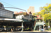
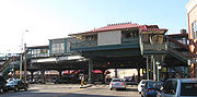
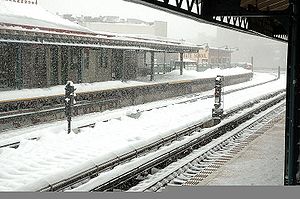
| 1 | 242nd Street – Van Cortlandt Park Subway station ( train) | Above Broadway at the jct. of W. 242nd St. 40°53′20"N 73°53′56"W |
Bronx | Only remaining terminal elevated subway station in Victorian Gothic architectural style Architectural style Architectural styles classify architecture in terms of the use of form, techniques, materials, time period, region and other stylistic influences. It overlaps with, and emerges from the study of the evolution and history of architecture... . Also has only remaining scrolled Scrollwork Scrollwork is an element of ornamentation and graphic design using a spiral. The name comes from by the supposed resemblance to the edge-on view of a rolled parchment scroll. "Scrollwork" is today mostly used in popular language for two-dimensional decorative flourishes and arabesques of all... station sign in entire system |
||
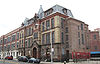
| 2 | 48th Police Precinct Station 48th Police Precinct Station 48th Police Precinct Station is a historic police station located at The Bronx in New York, New York. It was completed in 1901 and is a freestanding, three story rectangular block, seven bays wide. The facades are composed of yellow brick with stone trim in the Italian Renaissance Revival... |
1925 Bathgate Ave. 40°50′49"N 73°53′52"W |
The Bronx The Bronx The Bronx is the northernmost of the five boroughs of New York City. It is also known as Bronx County, the last of the 62 counties of New York State to be incorporated... |
|||
| 3 | 52nd Police Precinct Station House and Stable 52nd Police Precinct Station House and Stable 52nd Police Precinct Station House and Stable is a historic police station located at The Bronx in New York, New York. It was built 1904-1906 and is a three story, red brick structure approximately 50 feet by 80 feet in size. It is in the style of a Tuscan villa. It features a 21 foot square... |
3016 Webster Ave. 40°52′9"N 73°52′46"W |
The Bronx The Bronx The Bronx is the northernmost of the five boroughs of New York City. It is also known as Bronx County, the last of the 62 counties of New York State to be incorporated... |
|||
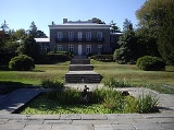
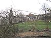
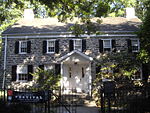
| 4 | Bartow-Pell Mansion and Carriage House | 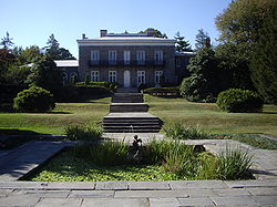 |
Pelham Bay Park, Shore Rd. 40°52′18"N 73°48′21"W |
Pelham Bay Park Pelham Bay Park Pelham Bay Park, located in the northeast corner of the New York City borough of The Bronx and extending partially into Westchester County, is at the largest public park in New York City. The section of the park within New York City's borders is more than three times the size of Manhattan's... |
||
| 5 | Bronx Borough Courthouse Bronx Borough Courthouse The Bronx Borough Courthouse is a historic courthouse building located in the Bronx in New York City. It was built between 1905 and 1915 in the Beaux-Arts style. It is a four story granite building with a two story base faced with rusticated stone bands. The north and east elevations have... |
 |
E. 161st St., 3rd and Brook Aves. 40°49′22"N 73°54′38"W |
Melrose Melrose, Bronx Melrose is primarily a residential neighborhood geographically located in the SouthWestern section of the borough of The Bronx in New York City. The neighborhood is part of Bronx Community Board 1. Its boundaries, starting from the North and moving clockwise are: East 161st Street to the North,... |
||
| 6 | Bronx Central Annex-U.S. Post Office United States Post Office-Bronx Central Annex Bronx Central Annex-U.S. Post Office is a historic post office building located at the Bronx, New York, United States. It was built from 1935 to 1937, and designed by consulting architect Thomas Harlan Ellett for the Office of the Supervising Architect. The building is constructed of smooth gray... |
558 Grand Concourse 40°49′8"N 73°55′37"W |
Bronx | |||
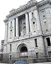
| 7 | Bronx County Courthouse Bronx County Courthouse The Bronx County Courthouse is a historic courthouse building located in the Bronx in New York City. It was designed in 1931 and built between 1931 and 1934. It is a nine story limestone building on a rusticated granite base in the Classical Revival style. It has four identical sides, an interior... |
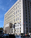 |
851 Grand Concourse 40°49′34"N 73°55′27"W |
Bronx | ||
| 8 | Casa Amadeo, antigua Casa Hernandez Casa Amadeo, antigua Casa Hernandez Casa Amadeo, antigua Casa Hernandez is a historic apartment building containing a noted record shop located in the Longwood section of The Bronx, New York, New York. It was built in 1905 and named the Manhaset apartment building. It is a six story, Neo-Renaissance style building with commercial... |
786 Prospect Ave. 40°49′9"N 73°54′8"W |
Bronx | |||
| 9 | Christ Church Complex Christ Church (Bronx, New York) The Christ Church Complex is a historic Episcopal parish church and related structures at 5030 Riverdale Avenue in the Riverdale area of The Bronx in New York City.... |
5030 Riverdale Ave. 40°53′56"N 73°54′25"W |
New York | |||
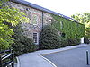
| 10 | Robert Colgate House Robert Colgate House Robert Colgate House, also known as Stonehurst, is a historic home located in the Bronx in New York City. It was built about 1860 and is a two story picturesque Italianate villa built of ashlar Maine granite. It features a low-pitched dormered roof with broad eaves surrounding a flat deck... |
5225 Sycamore Ave. 40°54′7"N 73°54′45"W |
New York | |||
| 11 | Concourse Yard Entry Buildings Concourse Yard Entry Buildings Concourse Yard Entry Buildings are two historic buildings located in the Kingsbridge neighborhood of The Bronx, New York, New York. They were built in 1933 as part of the Concourse Yard in the Art Deco style. The buildings were built next to one another to form a gateway to the yard. They are both... |
W. 205th St., bet. Jerome and Paul Aves. 40°52′34"N 73°53′21"W |
Kingsbridge, Bronx Kingsbridge, Bronx Kingsbridge is a working class residential neighborhood geographically located in the northwest Bronx in New York City. The neighborhood is part of Bronx Community Board 8. Its boundaries are Van Cortlandt Park to the north, Goulden Avenue to the east, West 225th Street to the south, and Irwin... |
|||
| 12 | Concourse Yard Substation Concourse Yard Substation Concourse Yard Substation is a historic electrical substation located in the Kingsbridge neighborhood of The Bronx, New York, New York. It was built in 1933 as part of the Concourse Yard in the Art Deco style. The building measures 50 feet by 100 feet... |
3119 Jerome Ave. 40°52′30"N 73°53′22"W |
Kingsbridge, Bronx Kingsbridge, Bronx Kingsbridge is a working class residential neighborhood geographically located in the northwest Bronx in New York City. The neighborhood is part of Bronx Community Board 8. Its boundaries are Van Cortlandt Park to the north, Goulden Avenue to the east, West 225th Street to the south, and Irwin... |
|||
| 13 | William E. Dodge House William E. Dodge House William E. Dodge House, also known as Greyston Conference Center, is a historic home located in Riverdale in the Bronx in New York City. It was built in 1863 and designed by noted architect James Renwick, Jr. It is a -story masonry structure in the Gothic Revival style. It was built for William... |
690 W. 247th St. 40°53′42"N 73°54′56"W |
New York | |||
| 14 | Dollar Savings Bank Dollar Savings Bank Dollar Savings Bank was founded in The Bronx, New York City in 1890. It went through a series of name changes and mergers, including a merger with the Dry Dock Savings Bank of New York, which formed Dollar Dry Dock Savings Bank, which was ultimately liquidated in 1992.Over the years it expanded... |
2792 3rd Ave. 40°48′54"N 73°55′8"W |
Bronx | New listing; refnum 11000228 | ||
| 15 | Edgehill Church at Spuyten Duyvil Edgehill Church at Spuyten Duyvil Edgehill Church at Spuyten Duyvil is a United Church of Christ parish church in The Bronx, New York. Its congregation was originally founded in 1869 as the mission chapel affiliated with the Riverdale Presbyterian Church, serving the workers at the nearby Johnson Iron Foundry... |
2550 Independence Ave. 40°52′48"N 73°55′13"W |
Spuyten Duyvil Spuyten Duyvil, Bronx Spuyten Duyvil is the name of a subsection of the Riverdale section of the Bronx in New York City. The area is named after Spuyten Duyvil Creek, a Dutch name with various historical spellings and meanings, the most plausible of which is "Spinning Devil", "Devil's Whirlpool", or "Devil's Spate"... |
|||
| 16 | Eighth Regiment Armory (commonly known as Kingsbridge Armory) | 29 W. Kingsbridge Rd. 40°52′7"N 73°53′55"W |
Kingsbridge Kingsbridge, Bronx Kingsbridge is a working class residential neighborhood geographically located in the northwest Bronx in New York City. The neighborhood is part of Bronx Community Board 8. Its boundaries are Van Cortlandt Park to the north, Goulden Avenue to the east, West 225th Street to the south, and Irwin... |
Romanesque structure with five-acre (2 ha) footprint built in 1910s is believed to be the world's largest armory. | ||
| 17 | Fonthill Castle and the Administration Building of the College of Mount St. Vincent Fonthill Castle and the Administration Building of the College of Mount St. Vincent Fonthill Castle and the Administration Building of the College of Mount St. Vincent are two historic buildings located at the College of Mount Saint Vincent in The Bronx, New York, New York.... |
W. 261st St. and Riverdale Ave. 40°54′49"N 73°54′34"W |
New York | |||
| 18 | Fort Schuyler | 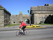 |
Throgs Neck at East River and Long Island Sound 40°48′20"N 73°47′34"W |
Throgs Neck | ||
| 19 | Grace Episcopal Church Grace Episcopal Church (Bronx, New York) Grace Episcopal Church is a historic Episcopal church at 116 City Island Avenue in The Bronx, New York, New York. The church was built in 1862 in the Carpenter Gothic style, and the rectory was built around that year in the Italian Villa style.... |
116 City Island Ave. 40°50′27"N 73°47′4"W |
City Island | |||
| 20 | Grand Concourse Historic District | 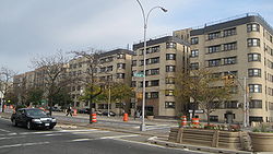 |
730-1000, 1100-1520, 1560, and 851-1675 Grand Concourse 40°49′52"N 73°55′26"W |
New York | ||
| 21 | Hall of Fame Complex Hall of Fame for Great Americans The Hall of Fame for Great Americans is the original hall of fame in the United States. "Fame" here means "renown"... |
 |
Bronx Community College Bronx Community College The Bronx Community College of The City University of New York is a community college in the City University of New York system located in the University Heights neighborhood of The Bronx.- History :... campus 40°51′31"N 73°54′52"W |
University Heights University Heights, Bronx University Heights is a residential neighborhood of the West Bronx in New York City. The neighborhood is part of Bronx Community Board 5 and Bronx Community Board 7. Its boundaries, starting from the north and moving clockwise, are: West 190th Street to the north, Jerome Avenue to the east, West... |
||
| 22 | Hertlein and Schlatter Silk Trimmings Factory Hertlein and Schlatter Silk Trimmings Factory Hertlein and Schlatter Silk Trimmings Factory is a historic factory building located in the Mott Haven section of The Bronx, New York, New York. The original building was built in 1887 and expanded in 1892 and 1910-1911. It is a five story brick building, 14 bays long. A six story extension was... |
454-464 E. 148th St. 40°48′51"N 73°54′59"W |
Mott Haven, Bronx Mott Haven, Bronx Mott Haven is a primarily residential neighborhood in the Southwestern section of The Bronx in New York City. Zip codes include 10451, 10454, and 10455. The neighborhood is part of Bronx Community Board 1... |
|||
| 23 | High Pumping Station High Pumping Station High Pumping Station is a historic pumping station located in The Bronx, New York, New York. It was built between 1901 and 1906, and is a rectangular red brick building with a steeply pitched slate covered gable roof. It was built as part of the Jerome Park Reservoir complex.It was listed on the... |
Jerome Ave. 40°52′42"N 73°53′12"W |
New York | |||
| 24 | House at 175 Belden Street House at 175 Belden Street The house at 175 Belden Street is a historic home located on City Island in the Bronx in New York City. It was built about 1880 and is a simple, small picturesque cottage with an asymmetrical cruciform plan.... |
175 Belden St. 40°50′17"N 73°46′57"W |
New York | |||
| 25 | Jackson Avenue Jackson Avenue (IRT White Plains Road Line) Jackson Avenue is a local station on the IRT White Plains Road Line of the New York City Subway. Located at the intersection of Jackson and Westchester Avenues in Melrose, Bronx, it is served by the 2 train at all times, and the 5 train at all times except late nights and rush hours in peak... Subway station ( trains) |
 |
Jct. of E. 152nd St. and Jackson and Westchester Aves. 40°49′0"N 73°54′29"W |
Bronx | ||
| 26 | Jerome Park Reservoir Jerome Park Reservoir The Jerome Park Reservoir is located in Jerome Park, a neighborhood in the North Bronx, New York City. It was built in 1906 to serve the Croton Aqueduct as part of the New York City water supply system.... |
Goulden, Reservoir and Sedgwick Aves. 40°52′40"N 73°53′44"W |
Bronx | |||
| 27 | Keeper's House at Williamsbridge Reservoir Keeper's House at Williamsbridge Reservoir Keeper's House at Williamsbridge Reservoir is a historic home located in The Bronx, New York, New York. It was built in 1889 as part of the Williamsbridge Reservoir complex. It is a -story, L-shaped stone house... |
3400 Reservoir Oval 40°52′43"N 73°52′34"W |
Bronx | |||
| 28 | Lisanti Chapel Lisanti Chapel Lisanti Chapel is a historic chapel at 740 E. 215th Street, Bronx, New York in the Baychester neighborhood of the Northern Bronx.It was built in 1905 by Francisco Lisanti, an Italian Immigrant,and added to the National Register of Historic Places in 2002.... |
740 E. 215th St. 40°52′48"N 73°51′48"W |
Bronx | |||
| 29 | Longwood Historic District (Bronx) Longwood Historic District (Bronx) The Longwood Historic District is a nationally recognized historic district located in the center of the Longwood neighborhood in the South Bronx, New York... |
Roughly bounded by Beck St., Longwood, Leggett, and Prospect Aves. 40°49′0"N 73°54′0"W |
New York | |||
| 30 | Lorillard Snuff Mill Lorillard Snuff Mill Built in about 1840 to replace an earlier building of the same function, the Lorillard Snuff Mill is the oldest existing tobacco manufacturing building in the United States. It was declared a National Historic Landmark in 1977.... |
 |
Off U.S. 1 40°51′36"N 73°52′35"W |
New York | ||
| 31 | Morris High School Historic District Morris High School Historic District Morris High School Historic District is a national historic district centered on a high school located at South Bronx, The Bronx, New York, New York. The district includes 51 contributing buildings. It includes the Morris High School, two streets of brick rowhouses, and Trinity Episcopal Church... |
Roughly bounded by Boston Rd., Jackson and Forrest Aves., and E. 166th and Home Sts. 40°49′38"N 73°54′15"W |
New York | |||
| 32 | Morris Park Morris Park (IRT Dyre Avenue Line) Morris Park is a station on the IRT Dyre Avenue Line of the New York City Subway. Served by the 5 train, it is located at Paulding Avenue and the Esplanade in Morris Park, Bronx.... Subway station ( train) |
Under Espalanade at Bogart and Colden Ave. and Hone Ave. 40°51′16"N 73°51′40"W |
Bronx | |||
| 33 | Mott Avenue Control House ( trains) | 149th St. and Grand Concourse 40°49′6.77"N 73°55′38.17"W |
Bronx | |||
| 34 | Mott Haven Historic District Mott Haven Historic District Mott Haven Historic District is a national historic district located at Mott Haven, The Bronx, New York, New York. The district includes 125 contributing buildings. It is primarily residential in character with four and five story row houses dating to the last half of the 19th century... |
An irregular pattern along Alexander Ave. and E. 140th St. 40°48′37"N 73°55′32"W |
Mott Haven, Bronx Mott Haven, Bronx Mott Haven is a primarily residential neighborhood in the Southwestern section of The Bronx in New York City. Zip codes include 10451, 10454, and 10455. The neighborhood is part of Bronx Community Board 1... |
|||
| 35 | New York Botanical Garden New York Botanical Garden - See also :* Education in New York City* List of botanical gardens in the United States* List of museums and cultural institutions in New York City- External links :* official website** blog*... |
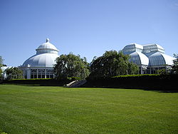 |
Southern and Bedford Park Blvds. 40°51′49"N 73°52′34"W |
Bronx Park Bronx Park Bronx Park, laid out along the Bronx River in the Bronx, New York, is the home of the New York Botanical Garden and the Bronx Zoo. Bicycle paths go northwest, north and east, along Mosholu Parkway, Bronx River Parkway and Pelham Parkway respectively... |
||
| 36 | New York, Westchester and Boston Railroad Administration Building New York, Westchester and Boston Railroad Administration Building The New York, Westchester and Boston Railroad Administration Building is a historic office building and railroad station located in the Van Nest section of The Bronx, New York, New York. The building was built in 1912 by the New York, Westchester and Boston Railway. It is built of concrete and has... |
481 Morris Park Ave. 40°50′29"N 73°52′23"W |
New York | |||
| 37 | Park Plaza Apartments | 1005 Jerome Ave. 40°49′50"N 73°55′30"W |
New York | |||
| 38 | Pelham Parkway Pelham Parkway (IRT White Plains Road Line) Pelham Parkway is a local station on the IRT White Plains Road Line of the New York City Subway. Located in the Bronx at the intersection of Pelham Parkway and White Plains Road, it is served by the 2 train at all times, and the 5 train during rush hours in the peak direction... Subway station ( trains) |
 |
Jct. of White Plains Rd. and Pelham Pkwy 40°51′26.05"N 73°52′3.39"W |
Bronx | ||
| 39 | Poe Cottage | 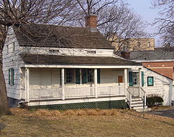 |
2640 Grand Concourse 40°51′55"N 73°53′40"W |
Bronx | ||
| 40 | Prospect Avenue Prospect Avenue (IRT White Plains Road Line) Prospect Avenue is a local station on the IRT White Plains Road Line of the New York City Subway. Located at the intersection of Prospect and Westchester Avenues in the Bronx, it is served by the 2 train at all times, and by the 5 train at all times except late nights and rush hours in peak... Subway station ( trains) |
 |
Jct. of Westchester and Lonwood Aves. and Prospect St. 40°49′11"N 73°54′8"W |
Bronx | ||
| 41 | Public School 11 Public School 11 Public School 11, also known as Highbridge School, is a historic school located at The Bronx, New York, New York. It is a brick and stone building in the Romanesque Revival style. It has three sections: a three story northern section with tower and rear extension built in 1889; a six bay, three... |
 |
1257 Ogden Ave. 40°50′23"N 73°55′35"W |
Bronx | ||
| 42 | Public School 15 Public School 15 Public School 15 is a historic school located at Eastchester, The Bronx, New York, New York. It was built in 1877 in the Victorian Gothic style. It is an "H" shaped red brick building on a stone foundation. It features a central picturesque bell tower with a steep pyramidal roof topped by a... |
4010 Dyre Ave. 40°53′27"N 73°49′52"W |
Eastchester, Bronx Eastchester, Bronx Eastchester is a working class neighborhood in the northeast Bronx borough of New York City in the United States. The neighborhood is part of Bronx Community Board 12... |
|||
| 43 | Public School 17 Public School 17 Public School 17 is a historic school located at City Island, The Bronx, New York, New York. It was designed by noted architect C. B. J. Snyder and built in 1897 in the Neo-Georgian style. A rear addition was built in 1930. It is a two story, five bay brick building on a high basement. It... |
190 Fordham St. 40°50′49"N 73°47′5"W |
City Island, New York | |||
| 44 | Rainey Memorial Gates Rainey Memorial Gates Rainey Memorial Gates is a historic entrance gate located at the New York Zoological Park in The Bronx, New York, New York. It was built in 1934 and constructed of sculpted bronze in the Art Deco style. It was designed by noted sculptor Paul Manship , who worked on them starting in 1926. It stands... |
New York Zoological Park Bronx Zoo The Bronx Zoo is located in the Bronx borough of New York City, within Bronx Park. It is the largest metropolitan zoo in the United States, comprising of park lands and naturalistic habitats, through which the Bronx River flows.... 40°51′18"N 73°52′40"W |
Bronx | Paul Manship Paul Manship Paul Howard Manship was an American sculptor.-Life:Manship began his art studies at the St. Paul School of Art in Minnesota. From there he moved to Philadelphia and continued his education at the Pennsylvania Academy of Fine Arts... , Sculptor; Charles A Platt, architect |
||
| 45 | C. Rieger's Sons Factory C. Rieger's Sons Factory C. Rieger's Sons Factory, also known as Arden Manufacturing Corporation and Piser Company, is a historic factory building located in the Mott Haven section of The Bronx, New York, New York. It was built in 1906, and is a six story building clad in yellow iron spot brick in the Romanesque Revival... |
450-452 E. 148th St. 40°48′51"N 73°55′1"W |
Mott Haven, Bronx Mott Haven, Bronx Mott Haven is a primarily residential neighborhood in the Southwestern section of The Bronx in New York City. Zip codes include 10451, 10454, and 10455. The neighborhood is part of Bronx Community Board 1... |
|||
| 46 | Riverdale Presbyterian Church Complex Riverdale Presbyterian Church Complex Riverdale Presbyterian Church Complex, also known as Duff House & Duff Cottage , is a historic Presbyterian church at 4761-4765 Henry Hudson Parkway in The Bronx, New York, New York. It was designed in 1863 by noted architect James Renwick, Jr. . It is a fieldstone building in the Late Gothic... |
4761-4765 Henry Hudson Parkway 40°53′45"N 73°54′32"W |
Riverdale | |||
| 47 | Simpson Street Simpson Street (IRT White Plains Road Line) Simpson Street is a local station on the IRT White Plains Road Line of the New York City Subway. Located at the intersection of Simpson Street and Westchester Avenue in the Bronx, it is served by the 2 train at all times, and the 5 train at all times except late nights and rush hours in the peak... Subway station ( trains) and Substation #18 |
 |
Jct. of Westchester Ave., bet. Simpson St. and Southern Blvd. 40°49′27"N 73°53′37"W |
Bronx | ||
| 48 | Henry F. Spaulding Coachman's House Henry F. Spaulding Coachman's House Henry F. Spaulding Coachman's House is a historic home located at Riverdale, The Bronx in New York, New York. It was built about 1880 and is representative of the Stick-Eastlake style. The main section is a -story cottage dwelling with board and batten siding... |
4970 Independence Ave. 40°53′53"N 73°54′41"W |
Bronx | |||
| 49 | St. Ann's Church Complex St. Ann's Church Complex (Bronx, New York) St. Ann's Church is a historic Episcopal church in the South Bronx, New York City. It was built in 1840 and donated by Gouverneur Morris Jr. as a family memorial. It is a fieldstone building in the Gothic Revival style with a vernacular Greek Revival style tower... |
 |
295 St. Ann's Ave. 40°48′30"N 73°55′3"W |
South Bronx South Bronx The South Bronx is an area of the New York City borough of The Bronx. The neighborhoods of Tremont, University Heights, Highbridge, Morrisania, Soundview, Hunts Point, and Castle Hill are sometimes considered part of the South Bronx.... |
||
| 50 | St. James' Episcopal Church and Parish House St. James' Episcopal Church and Parish House St. James' Episcopal Church and Parish House is a historic Episcopal church at 2500 Jerome Avenue and 190th Street, in the Fordham section of The Bronx, New York City, New York.... |
2500 Jerome Ave. 40°51′50"N 73°54′0"W |
Bronx | |||
| 51 | St. Peter's Church, Chapel and Cemetery Complex St. Peter's Church, Chapel and Cemetery Complex St. Peter's Church, Chapel and Cemetery Complex is a historic Episcopal Gothic Revival church at 2500 Westchester Avenue and Saint Peters Avenue in the Bronx, New York City.... |
2500 Westchester Ave. 40°50′17"N 73°50′41"W |
Bronx | |||
| 52 | Sunnyslope Sunnyslope (Bronx, New York) Sunnyslope, also known as Bright Temple A.M.E. Church, is a historic home located in the South Bronx in New York City. It was built about 1860 and is a -story Gothic Revival–style house built in the Picturesque mode... |
812 Faile St. 40°49′2"N 73°53′14"W |
Bronx | |||
| 53 | Tremont Baptist Church Tremont Baptist Church Tremont Baptist Church is a historic Baptist church located at The Bronx, New York, New York. The church was built in two phases between 1904 and 1912. It is a one story building above a raised basement in the Late Gothic Revival style. It is 50 feet tall with a 75 foot tall offset corner tower... |
324 E. Tremont Ave. 40°50′53.64"N 73°54′8.37"W |
Tremont Tremont, Bronx Tremont is a low income residential neighborhood geographically located in the west Bronx, New York City. The neighborhood is part of Bronx Community Board 5. Its boundaries, starting from the north and moving clockwise are: East 183rd Street to the north, Webster Avenue to the east, the... |
|||
| 54 | United Workers Cooperatives United Workers Cooperatives United Workers Cooperatives, also known as Allerton Coops, is a historic apartment building complex located in The Bronx, New York, New York. The complex includes three contributing buildings and five contributing structures. The Tudor Revival style buildings were built during two construction... |
2700-2870 Bronx Park E 40°51′59"N 73°52′11"W |
Hunts Point Hunts Point, Bronx Hunts Point is a low-income neighborhood located on a peninsula in the South Bronx in New York City. It is the location of one of the largest food distribution facilities in the world. The neighborhood is part of Bronx Community Board 2. Its boundaries are the Bruckner Expressway to the west and... |
|||
| 55 | US Post Office-Morrisania United States Post Office (Morrisania, Bronx) US Post Office-Morrisania, originally Station "T," is a historic post office building located at Morrisania in The Bronx, New York, United States. It was built in 1936, and designed by consulting architect William Dewey Foster for the Office of the Supervising Architect... |
442 E. 167th St. 40°49′47"N 73°54′34"W |
Morrisania Morrisania, Bronx Morrisania is the historical name for the South Bronx and derives from the powerful and aristocratic Morris family, who at one time owned all of the Manor of Morrisania. Today the name is most commonly associated with the village of Morrisania, which is only a small corner of the original... |
|||
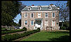
| 56 | Valentine-Varian House Valentine-Varian House The Valentine-Varian House, built in 1758 by Isaac Valentine and located in the Norwood section of the Bronx is the borough's second oldest house and oldest remaining farmhouse. The house remained in the Varian family, which included Isaac Varian, New York's 63rd Mayor until 1905, when it was sold... |
 |
3266 Bainbridge Ave. 40°52′38"N 73°52′47"W |
Bronx | ||
| 57 | Frederick Van Cortlandt House Van Cortlandt House Museum The Van Cortlandt House Museum, also known as Frederick Van Cortlandt House or Van Cortlandt House, is the oldest building in The Bronx, New York City.... |
 |
Van Cortlandt Park at 242nd St. 40°53′40"N 73°53′35"W |
Bronx | ||
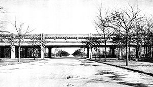
| 58 | Washington Bridge Washington Bridge The Washington Bridge carries six lanes of traffic over the Harlem River in New York City between the boroughs of Manhattan and the Bronx, connecting 181st Street and Amsterdam Avenue in the Washington Heights section of Manhattan to University Avenue in the Morris Heights section of the Bronx... |
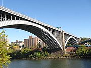 |
Between Amsterdam and Undercliff Aves. 40°50′42"N 73°55′29"W |
Bronx | Bridge from Harlem to the Bronx | |
| 59 | Wave Hill Wave Hill Wave Hill is an estate and garden in New York.Wave Hill may also refer to:*Kalkaringi, Northern Territory, formerly known as Wave Hill, a township in the Northern Territory of Australia... |
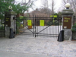 |
675 W. 252nd St. 40°53′55"N 73°54′47"W |
Riverdale | ||
| 60 | Westchester Square Subway station ( trains) | 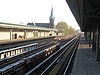 |
Above Westchester Ave., from Overing St. to Ferris Place 40°50′23"N 73°50′38"W |
Bronx | ||
| 61 | Woodlawn Cemetery | Webster Avenue & East 233rd Street 40°53′43"N 73°51′49"W |
Bronx | Cemetery illustrates transition from rural cemetery to 20th-century styles; final resting place of Robert Moses Robert Moses Robert Moses was the "master builder" of mid-20th century New York City, Long Island, Rockland County, and Westchester County, New York. As the shaper of a modern city, he is sometimes compared to Baron Haussmann of Second Empire Paris, and is one of the most polarizing figures in the history of... , Elizabeth Cady Stanton Elizabeth Cady Stanton Elizabeth Cady Stanton was an American social activist, abolitionist, and leading figure of the early woman's movement... and Jay Gould Jay Gould Jason "Jay" Gould was a leading American railroad developer and speculator. He has long been vilified as an archetypal robber baron, whose successes made him the ninth richest American in history. Condé Nast Portfolio ranked Gould as the 8th worst American CEO of all time... , among others. |
||
| 62 | Woodlawn Woodlawn (IRT Jerome Avenue Line) Woodlawn is the northern terminal of the New York City Subway's IRT Jerome Avenue Line. Located at the intersection of Bainbridge and Jerome Avenue in the Bronx neighborhood of Woodlawn, it is served by the 4 train at all times, providing service to the South Bronx, the East Side of Manhattan and... Subway station ( train) |
Jct. of Bainbridge Ave. and Jerome Ave. 40°53′9"N 73°52′45"W |
Bronx | Arts and Crafts Arts and Crafts movement Arts and Crafts was an international design philosophy that originated in England and flourished between 1860 and 1910 , continuing its influence until the 1930s... -inspired terminal station |
See also
-
- Statewide: National Register of Historic Places listings in New York
- Citywide: Manhattan, Queens, Staten Island, Brooklyn
- List of New York City Designated Landmarks in The Bronx
External links
- A useful list of the above sites, with street addresses and other information, is available at Bronx County listing, at National Register of Historic Places.Com, a private site serving up public domain information on NRHPs.