

List of Pennsylvania state historical markers in Erie County
Encyclopedia
This is intended to be a complete list of the official state historical markers placed in Erie County, Pennsylvania
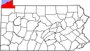
Erie County, Pennsylvania
Erie County is a county located in the U.S. state of Pennsylvania. As of 2010, the population was 280,566. Its county seat is the City of Erie.- Geography :...
by the Pennsylvania Historical and Museum Commission
Pennsylvania Historical and Museum Commission
The Pennsylvania Historical and Museum Commission is the governmental agency of the Commonwealth of Pennsylvania responsible for the collection, conservation and interpretation of Pennsylvania's historic heritage...
(PHMC). The locations of the historical markers, as well as the latitude and longitude coordinates as provided by the PHMC's database, are included below when available. There are 53 historical markers located in Erie County.
Historical markers
| Marker title | Image | Date dedicated | Location | Marker type | Topics |
|---|---|---|---|---|---|
| African Americans in Battle of Lake Erie | Erie Maritime Museum Erie Maritime Museum Erie Maritime Museum is a maritime museum located on Presque Isle Bay in downtown Erie, Pennsylvania. It was the first new PHMC museum in twenty years when it opened its doors on May 21, 1998... , 150 East Front Street, Erie Erie, Pennsylvania Erie is a city located in northwestern Pennsylvania in the United States. Named for the lake and the Native American tribe that resided along its southern shore, Erie is the state's fourth-largest city , with a population of 102,000... °N °W |
City | African American, Military, War of 1812 | ||
| Anthony Wayne Anthony Wayne Anthony Wayne was a United States Army general and statesman. Wayne adopted a military career at the outset of the American Revolutionary War, where his military exploits and fiery personality quickly earned him a promotion to the rank of brigadier general and the sobriquet of Mad Anthony.-Early... |
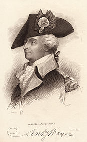 |
East 6th Street at Ash Street, Erie Erie, Pennsylvania Erie is a city located in northwestern Pennsylvania in the United States. Named for the lake and the Native American tribe that resided along its southern shore, Erie is the state's fourth-largest city , with a population of 102,000... °N °W |
Roadside | American Revolution, Forts, Military | |
| Canal Basin Canal basin A canal basin is an expanse of waterway alongside or at the end of a canal, and wider than the canal, constructed to allow boats to moor or unload cargo without impeding the progress of other traffic, and to allow room for turning, thus serving as a winding hole... |
North end of State State, Erie Erie, Pennsylvania Erie is a city located in northwestern Pennsylvania in the United States. Named for the lake and the Native American tribe that resided along its southern shore, Erie is the state's fourth-largest city , with a population of 102,000... °N °W |
Roadside | Canals, Navigation, Transportation | ||
| Captain C.V. Gridley Charles Vernon Gridley Charles Vernon Gridley was an officer in the United States Navy during the American Civil War and the Spanish-American War.-Early life:... |
East Lake Road, Erie Erie, Pennsylvania Erie is a city located in northwestern Pennsylvania in the United States. Named for the lake and the Native American tribe that resided along its southern shore, Erie is the state's fourth-largest city , with a population of 102,000... °N °W |
Roadside | Military, Military Post-Civil War | ||
| Captain Daniel Dobbins Daniel Dobbins Daniel Dobbins was a sailing master in the United States Navy and captain in the United States Revenue Cutter Service... |
Dobbins Landing Dobbins Landing Dobbins Landing is a popular tourist area located at the edge of Presque Isle Bay at the terminus of State Street in Erie, Pennsylvania. Consisting of a wharf and adjoining facilities, the landing includes the Bicentennial Tower, the Sheraton Erie Hotel, and the Bayfront Convention Center.The... , foot of State Street, Erie Erie, Pennsylvania Erie is a city located in northwestern Pennsylvania in the United States. Named for the lake and the Native American tribe that resided along its southern shore, Erie is the state's fourth-largest city , with a population of 102,000... 42.13768°N 80.09075°W |
Roadside | George Washington, Military, War of 1812 | ||
| Cashier's House Cashier's House The Cashier's House is a three-story, plastered brick, Greek Revival building located on State Street in Erie, Pennsylvania. It was documented by the Historic American Buildings Survey in 1934... |
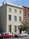 |
417 State Street, Erie Erie, Pennsylvania Erie is a city located in northwestern Pennsylvania in the United States. Named for the lake and the Native American tribe that resided along its southern shore, Erie is the state's fourth-largest city , with a population of 102,000... 42.131°N 80.0862°W |
Roadside | Buildings, Business & Industry, Houses & Homesteads | |
| Circus History | US 20 U.S. Route 20 in Pennsylvania U.S. Route 20 is a east-west U.S. Highway in Pennsylvania, which clips the northeastern corner of the state, running entirely in Erie County. While it is part of the nation's longest road, it features the shortest segment of any two-digit U.S. route in the commonwealth... at the Diamond in Girard Girard, Pennsylvania Girard is a borough in Erie County, Pennsylvania, United States. The population was 3,164 at the 2000 census. It is part of the Erie Metropolitan Statistical Area.-Geography:Girard is located at .... 42.00007°N 80.31697°W |
Roadside | Performers | ||
| Climax Locomotives Climax locomotive A Climax locomotive is a type of geared steam locomotive in which the two steam cylinders were attached to a transmission located under the center of the boiler. This transmits power to driveshafts running to the front and rear trucks.... |
PA 77 Pennsylvania Route 77 Pennsylvania Route 77 is a long east–west state highway located in northwest Pennsylvania. The western terminus of the route is at Pennsylvania Route 27 in Meadville... at south end of Corry Corry, Pennsylvania Corry is a city located in northwestern Pennsylvania in the United States. With a population of 6,834 at the 2000 United States Census, it is the second largest city in Erie County. Corry is a part of the Erie Metropolitan Statistical Area... 41.91962°N 79.64378°W |
Roadside | Business & Industry, Railroads, Transportation | ||
| Col. Philip Cochran Philip Cochran Philip Gerald Cochran was an officer in the United States Army Air Corps. Cochran developed many tactical air combat, air transport, and air assault techniques during the war, particularly in Burma during operations as co-commander of the 1st Air Commando Group... |
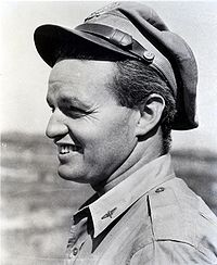 |
Erie County World War II World War II World War II, or the Second World War , was a global conflict lasting from 1939 to 1945, involving most of the world's nations—including all of the great powers—eventually forming two opposing military alliances: the Allies and the Axis... Memorial, State Street and Glenwood Parkway, Erie Erie, Pennsylvania Erie is a city located in northwestern Pennsylvania in the United States. Named for the lake and the Native American tribe that resided along its southern shore, Erie is the state's fourth-largest city , with a population of 102,000... °N °W |
Roadside | Military, Military Post-Civil War | |
| Col. Strong Vincent Strong Vincent Strong Vincent was a lawyer who became famous as a U.S. Army officer during the fighting on Little Round Top at the American Civil War Battle of Gettysburg, where he was mortally wounded.-Early life:... |
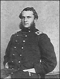 |
Northeast corner of High Street and 1st Street, Waterford Waterford, Pennsylvania Waterford is a borough in Erie County, Pennsylvania, United States. The population was 1,449 at the 2000 census. It is part of the Erie Metropolitan Statistical Area.-Geography:Waterford is located at .... 41.94037°N 79.98285°W |
Roadside | Civil War, Military | |
| Colt's Station | PA 89 Pennsylvania Route 89 Pennsylvania Route 89 is a long north–south state highway located in northwestern Pennsylvania. The southern terminus of the route is at Pennsylvania Route 8 and Pennsylvania Route 27 in Titusville. The northern terminus is at Pennsylvania Route 5 north of North East.-Route description:PA 89... at PA 430 Pennsylvania Route 430 Pennsylvania Route 430 is an long state highway located in Erie county in Pennsylvania. The western terminus is at US 20 in Wesleyville. The eastern terminus is the New York state line near Findley Lake, NY- History :... , Greenfield Township Greenfield Township, Erie County, Pennsylvania Greenfield Township is a township in Erie County, Pennsylvania, United States. The population was 1,909 at the 2000 census.-Geography:According to the United States Census Bureau, the township has a total area of , of which, of it is land and of it is water.-Demographics:As of the census of... 42.11883°N 79.82435°W |
Roadside | Government & Politics, Government & Politics 18th Century, Navigation, Transportation | ||
| Corry State Fish Hatchery | 13365 US 6 U.S. Route 6 in Pennsylvania U.S. Route 6 travels east–west near the north edge of the U.S. state of Pennsylvania from the Ohio state line near Pymatuning Reservoir east to the Mid-Delaware Bridge over the Delaware River into Port Jervis, New York. It is the longest highway segment in the Commonwealth. Most of it is a... , Corry Corry, Pennsylvania Corry is a city located in northwestern Pennsylvania in the United States. With a population of 6,834 at the 2000 United States Census, it is the second largest city in Erie County. Corry is a part of the Erie Metropolitan Statistical Area... 41.93089°N 79.67114°W |
Roadside | Environment, Government & Politics 20th Century, Sports | ||
| Creation of the Pennsylvania Game Commission Pennsylvania Game Commission The Pennsylvania Game Commission is the state agency responsible for wildlife conservation and management in Pennsylvania in the United States... |
Northwest corner of Corry City Park, at the intersection of North Center and Smith Streets °N °W |
Roadside | Environment, Government & Politics 20th Century | ||
| Drake Well Park Drake Well Museum The Drake Well Museum is a museum that interprets the birth of the American oil industry in 1859 by "Colonel" Edwin Drake along the banks of Oil Creek in Cherrytree Township, Venango County, Pennsylvania in the United States. The museum collects and preserves related artifacts... |
PA 8 Pennsylvania Route 8 Pennsylvania Route 8 is a major long route in western Pennsylvania. Officially, PA 8 is named the William Flinn Highway. Its southern terminus is at Interstate 376, U.S. Route 22, and U.S. Route 30 in Pittsburgh... just south of Union City Union City, Pennsylvania Union City is a borough in Erie County, Pennsylvania, southeast of Erie. In the twentieth century, there were three large chair factories, planing and grist mills, a powdered milk plant, and several furniture factories. In 1900, 3,104 people lived here, and in 1910, 3,684 people lived here. The... 41.88958°N 79.84712°W |
Roadside | Business & Industry, Oil & Gas | ||
| Edinboro State College Edinboro University of Pennsylvania Edinboro University is a public liberal arts university located in Edinboro, Pennsylvania, USA and one of 14 schools associated with the Pennsylvania State System of Higher Education. The town is named after Edinburgh, Scotland. It is also not to be confused with the University of Edinburgh... |
US 6N U.S. Route 6N U.S. Route 6N is a long auxiliary route of U.S. Route 6 located in Erie County, Pennsylvania. The western terminus is at U.S. Route 20 in West Springfield a half-mile north of Interstate 90 exit 3. Its eastern terminus is at U.S. Route 6 and U.S... at the campus in Edinboro Edinboro, Pennsylvania Edinboro is a borough in Erie County, Pennsylvania, United States. It is part of the Erie Metropolitan Statistical Area. As home to Edinboro University of Pennsylvania, it is a small college town, as well as a "resort community"... 41.8788°N 80.11615°W |
City | Education | ||
| Edinboro State Teachers College Edinboro University of Pennsylvania Edinboro University is a public liberal arts university located in Edinboro, Pennsylvania, USA and one of 14 schools associated with the Pennsylvania State System of Higher Education. The town is named after Edinburgh, Scotland. It is also not to be confused with the University of Edinburgh... |
PA 99 Pennsylvania Route 99 Pennsylvania Route 99 is a long state highway located in western Pennsylvania. The northern terminus is at U.S. Route 19 near Erie. The southern terminus is at U.S. Route 6 and U.S... in front of college, Edinboro Edinboro, Pennsylvania Edinboro is a borough in Erie County, Pennsylvania, United States. It is part of the Erie Metropolitan Statistical Area. As home to Edinboro University of Pennsylvania, it is a small college town, as well as a "resort community"... (Missing) |
City | Education | ||
| Erie Erie, Pennsylvania Erie is a city located in northwestern Pennsylvania in the United States. Named for the lake and the Native American tribe that resided along its southern shore, Erie is the state's fourth-largest city , with a population of 102,000... |
US 20 U.S. Route 20 in Pennsylvania U.S. Route 20 is a east-west U.S. Highway in Pennsylvania, which clips the northeastern corner of the state, running entirely in Erie County. While it is part of the nation's longest road, it features the shortest segment of any two-digit U.S. route in the commonwealth... , west of Erie Erie, Pennsylvania Erie is a city located in northwestern Pennsylvania in the United States. Named for the lake and the Native American tribe that resided along its southern shore, Erie is the state's fourth-largest city , with a population of 102,000... °N °W |
Roadside | Cities & Towns, Early Settlement, Forts, Military | ||
| Erie Erie, Pennsylvania Erie is a city located in northwestern Pennsylvania in the United States. Named for the lake and the Native American tribe that resided along its southern shore, Erie is the state's fourth-largest city , with a population of 102,000... |
US 20 U.S. Route 20 in Pennsylvania U.S. Route 20 is a east-west U.S. Highway in Pennsylvania, which clips the northeastern corner of the state, running entirely in Erie County. While it is part of the nation's longest road, it features the shortest segment of any two-digit U.S. route in the commonwealth... , east of Erie Erie, Pennsylvania Erie is a city located in northwestern Pennsylvania in the United States. Named for the lake and the Native American tribe that resided along its southern shore, Erie is the state's fourth-largest city , with a population of 102,000... °N °W |
Roadside | Cities & Towns, Forts, Military, War of 1812 | ||
| Erie Erie, Pennsylvania Erie is a city located in northwestern Pennsylvania in the United States. Named for the lake and the Native American tribe that resided along its southern shore, Erie is the state's fourth-largest city , with a population of 102,000... |
US 19 U.S. Route 19 in Pennsylvania U.S. Route 19 in Pennsylvania closely parallels Interstate 79 for its entire length. US 19 enters Pennsylvania in Greene County near Mount Morris. Its northern terminus is in the city of Erie. Part is named for Commodore Oliver Hazard Perry, hero of the Battle of Lake Erie.-Route description:In... , south of Erie Erie, Pennsylvania Erie is a city located in northwestern Pennsylvania in the United States. Named for the lake and the Native American tribe that resided along its southern shore, Erie is the state's fourth-largest city , with a population of 102,000... 42.04369°N 80.0745°W |
Roadside | Cities & Towns, Forts, Military, War of 1812 | ||
| Erie County Erie County, Pennsylvania Erie County is a county located in the U.S. state of Pennsylvania. As of 2010, the population was 280,566. Its county seat is the City of Erie.- Geography :... |
County Courthouse, West 6th Street between Peach Peach Street Peach Street, part of U.S. Route 19, is a main artery serving downtown Erie, Pennsylvania. Once surrounded by nothing but rolling hills and farmland, "Upper Peach Street" , is the most significant center of urban sprawl in Erie and is now home to numerous strip plazas, a major shopping mall and... ] and Sassafras Streets, Erie Erie, Pennsylvania Erie is a city located in northwestern Pennsylvania in the United States. Named for the lake and the Native American tribe that resided along its southern shore, Erie is the state's fourth-largest city , with a population of 102,000... °N °W |
City | Government & Politics, Government & Politics 19th Century, Military, Native American | ||
| Erie Extension Canal Beaver and Erie Canal The Beaver and Erie Canal, also known as the Erie Extension Canal, was part of the Pennsylvania Canal system and consisted of three sections: the Beaver Division, the Shenango Division, and the Conneaut Division... |
PA 18 Pennsylvania Route 18 Pennsylvania Route 18 is a major north–south highway in Western Pennsylvania whose southern terminus is at the West Virginia state line in Greene County, Pennsylvania near the village of Garrison, while the northern terminus is at PA Route 5 in Lake City, Pennsylvania... at Platea Platea, Pennsylvania Platea is a borough in Erie County, Pennsylvania, United States. The population was 474 at the 2000 census.-Geography:Platea is located at .... 41.95135°N 80.3291°W |
Roadside | Canals, Navigation, Transportation | ||
| Erie Extension Canal Beaver and Erie Canal The Beaver and Erie Canal, also known as the Erie Extension Canal, was part of the Pennsylvania Canal system and consisted of three sections: the Beaver Division, the Shenango Division, and the Conneaut Division... |
US 20 U.S. Route 20 in Pennsylvania U.S. Route 20 is a east-west U.S. Highway in Pennsylvania, which clips the northeastern corner of the state, running entirely in Erie County. While it is part of the nation's longest road, it features the shortest segment of any two-digit U.S. route in the commonwealth... at Asbury Road, Millcreek Township Millcreek Township, Erie County, Pennsylvania Millcreek Township is a township in Erie County, Pennsylvania, United States. The population was 53,515 at the 2010 census. It is the largest suburb of Erie, Pennsylvania and the sixth-largest municipality in the state; larger than the cities of Altoona and Harrisburg.Millcreek Township is home to... 42.07158°N 80.18237°W |
Roadside | Canals, Navigation, Transportation | ||
| Erie Land Lighthouse Erie Land Light The Erie Land Light, also known as the Old Presque Isle Light, is a lighthouse in Erie, Pennsylvania. It is one of the three lighthouses in Erie, along with the Presque Isle Light and the North Pier Light. The lighthouse is located in Lighthouse Park at the end of Lighthouse Street.The lighthouse... |
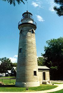 |
At the site of the lighthouse, 2 Lighthouse Street, Erie Erie, Pennsylvania Erie is a city located in northwestern Pennsylvania in the United States. Named for the lake and the Native American tribe that resided along its southern shore, Erie is the state's fourth-largest city , with a population of 102,000... °N °W |
City | Buildings, Navigation | |
| Flagship Niagara USS Niagara (1813) The US Brig Niagara or the Flagship Niagara, is a wooden-hulled brig that served as the relief flagship for Oliver Hazard Perry in the Battle of Lake Erie during the War of 1812. It is one of last remaining ships from the War of 1812. The Niagara is usually docked behind the Erie Maritime Museum in... |
At property on State Street, Erie Erie, Pennsylvania Erie is a city located in northwestern Pennsylvania in the United States. Named for the lake and the Native American tribe that resided along its southern shore, Erie is the state's fourth-largest city , with a population of 102,000... °N °W |
Roadside | Military, War of 1812 | ||
| Fort Le Boeuf Fort Le Boeuf Fort Le Boeuf, , was a fort established by the French in 1753 on a fork of French Creek, in present-day Waterford, in northwest Pennsylvania... (Plaque) |
US 19 U.S. Route 19 in Pennsylvania U.S. Route 19 in Pennsylvania closely parallels Interstate 79 for its entire length. US 19 enters Pennsylvania in Greene County near Mount Morris. Its northern terminus is in the city of Erie. Part is named for Commodore Oliver Hazard Perry, hero of the Battle of Lake Erie.-Route description:In... , opposite Fort Le Boeuf Museum, Waterford Waterford, Pennsylvania Waterford is a borough in Erie County, Pennsylvania, United States. The population was 1,449 at the 2000 census. It is part of the Erie Metropolitan Statistical Area.-Geography:Waterford is located at .... 41.94008°N 79.98297°W |
Plaque | Forts, French & Indian War, George Washington, Military | ||
| Fort LeBoeuf | US 19 U.S. Route 19 in Pennsylvania U.S. Route 19 in Pennsylvania closely parallels Interstate 79 for its entire length. US 19 enters Pennsylvania in Greene County near Mount Morris. Its northern terminus is in the city of Erie. Part is named for Commodore Oliver Hazard Perry, hero of the Battle of Lake Erie.-Route description:In... in Waterford Waterford, Pennsylvania Waterford is a borough in Erie County, Pennsylvania, United States. The population was 1,449 at the 2000 census. It is part of the Erie Metropolitan Statistical Area.-Geography:Waterford is located at .... 41.94015°N 79.98262°W |
Roadside | Forts, French & Indian War, Military, Native American | ||
| Fort LeBoeuf Memorial | Property on US 19 U.S. Route 19 in Pennsylvania U.S. Route 19 in Pennsylvania closely parallels Interstate 79 for its entire length. US 19 enters Pennsylvania in Greene County near Mount Morris. Its northern terminus is in the city of Erie. Part is named for Commodore Oliver Hazard Perry, hero of the Battle of Lake Erie.-Route description:In... , Waterford Waterford, Pennsylvania Waterford is a borough in Erie County, Pennsylvania, United States. The population was 1,449 at the 2000 census. It is part of the Erie Metropolitan Statistical Area.-Geography:Waterford is located at .... 41.94037°N 79.98275°W |
Roadside | Forts, French & Indian War, George Washington, Military | ||
| Fort Presque Isle Fort Presque Isle Fort Presque Isle was a fort built by French soldiers in 1753 along Presque Isle Bay at present-day Erie, Pennsylvania... |
6th and Parade Streets, Erie Erie, Pennsylvania Erie is a city located in northwestern Pennsylvania in the United States. Named for the lake and the Native American tribe that resided along its southern shore, Erie is the state's fourth-largest city , with a population of 102,000... 42.1326°N 80.07692°W |
Roadside | Forts, French & Indian War, Military, Native American, Roads | ||
| French Creek French Creek (Allegheny River) French Creek is a tributary of the Allegheny River in northwestern Pennsylvania and western New York in the United States.- Etymology :... |
|
US 19 U.S. Route 19 in Pennsylvania U.S. Route 19 in Pennsylvania closely parallels Interstate 79 for its entire length. US 19 enters Pennsylvania in Greene County near Mount Morris. Its northern terminus is in the city of Erie. Part is named for Commodore Oliver Hazard Perry, hero of the Battle of Lake Erie.-Route description:In... , slightly north of US 6 U.S. Route 6 in Pennsylvania U.S. Route 6 travels east–west near the north edge of the U.S. state of Pennsylvania from the Ohio state line near Pymatuning Reservoir east to the Mid-Delaware Bridge over the Delaware River into Port Jervis, New York. It is the longest highway segment in the Commonwealth. Most of it is a... , south of Waterford Waterford, Pennsylvania Waterford is a borough in Erie County, Pennsylvania, United States. The population was 1,449 at the 2000 census. It is part of the Erie Metropolitan Statistical Area.-Geography:Waterford is located at .... 41.88482°N 79.99943°W |
Roadside | Early Settlement, Ethnic & Immigration, George Washington, Transportation | |
| George Washington George Washington George Washington was the dominant military and political leader of the new United States of America from 1775 to 1799. He led the American victory over Great Britain in the American Revolutionary War as commander-in-chief of the Continental Army from 1775 to 1783, and presided over the writing of... |
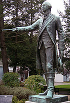 |
US 19 U.S. Route 19 in Pennsylvania U.S. Route 19 in Pennsylvania closely parallels Interstate 79 for its entire length. US 19 enters Pennsylvania in Greene County near Mount Morris. Its northern terminus is in the city of Erie. Part is named for Commodore Oliver Hazard Perry, hero of the Battle of Lake Erie.-Route description:In... , at George Washington Memorial Park, Waterford Waterford, Pennsylvania Waterford is a borough in Erie County, Pennsylvania, United States. The population was 1,449 at the 2000 census. It is part of the Erie Metropolitan Statistical Area.-Geography:Waterford is located at .... 41.94007°N 79.98282°W |
Roadside | French & Indian War, George Washington, Government & Politics, Government & Politics 18th Century, Military | |
| Harry Kellar Harry Kellar Harry Kellar was an American magician who presented large stage shows during the late 19th and early 20th centuries.... (1849–1922) |
Griswold Park, south side of West 13th Street, between Peach Peach Street Peach Street, part of U.S. Route 19, is a main artery serving downtown Erie, Pennsylvania. Once surrounded by nothing but rolling hills and farmland, "Upper Peach Street" , is the most significant center of urban sprawl in Erie and is now home to numerous strip plazas, a major shopping mall and... and Sassafras Streets, Erie Erie, Pennsylvania Erie is a city located in northwestern Pennsylvania in the United States. Named for the lake and the Native American tribe that resided along its southern shore, Erie is the state's fourth-largest city , with a population of 102,000... °N °W |
Roadside | Performers, Professions & Vocations | ||
| Harry T. Burleigh Harry Burleigh Henry "Harry" Thacker Burleigh , a baritone, was an African American classical composer, arranger, and professional singer... |
East 6th Street, Erie Erie, Pennsylvania Erie is a city located in northwestern Pennsylvania in the United States. Named for the lake and the Native American tribe that resided along its southern shore, Erie is the state's fourth-largest city , with a population of 102,000... °N °W |
Roadside | African American, Music & Theater, Performers | ||
| Ida M. Tarbell Ida M. Tarbell Ida Minerva Tarbell was an American teacher, author and journalist. She was known as one of the leading "muckrakers" of the progressive era, work known in modern times as "investigative journalism". She wrote many notable magazine series and biographies... |
PA 8 Pennsylvania Route 8 Pennsylvania Route 8 is a major long route in western Pennsylvania. Officially, PA 8 is named the William Flinn Highway. Its southern terminus is at Interstate 376, U.S. Route 22, and U.S. Route 30 in Pittsburgh... near Hatch Hollow Road, southwest of Wattsburg Wattsburg, Pennsylvania Wattsburg is a borough in Erie County, Pennsylvania, United States. The population was 378 at the 2000 census. It is part of the Erie Metropolitan Statistical Area.Wattsburg is along the banks of French Creek .... 41.9641°N 79.85165°W |
Roadside | Abraham Lincoln, Oil & Gas, Women, Writers | ||
| John Nelson John Nelson John Nelson may refer to:*John Nelson , Australian political figure*John Nelson , US baseball player... (1917–1959) |
3923 Main Street, Lawrence Park Township °N °W |
City | Civil Rights, Government & Politics 20th Century, Labor | ||
| Joshua M. Merrill (1828–1904) | Between 19 and 37 North Center Street, Corry Corry, Pennsylvania Corry is a city located in northwestern Pennsylvania in the United States. With a population of 6,834 at the 2000 United States Census, it is the second largest city in Erie County. Corry is a part of the Erie Metropolitan Statistical Area... °N °W |
Roadside | Invention, Oil & Gas, Professions & Vocations | ||
| LP Gas Industry | |
US 19 U.S. Route 19 in Pennsylvania U.S. Route 19 in Pennsylvania closely parallels Interstate 79 for its entire length. US 19 enters Pennsylvania in Greene County near Mount Morris. Its northern terminus is in the city of Erie. Part is named for Commodore Oliver Hazard Perry, hero of the Battle of Lake Erie.-Route description:In... at square in Waterford Waterford, Pennsylvania Waterford is a borough in Erie County, Pennsylvania, United States. The population was 1,449 at the 2000 census. It is part of the Erie Metropolitan Statistical Area.-Geography:Waterford is located at .... (Missing) |
Roadside | Business & Industry, Oil & Gas | |
| Old Custom House | State Street, Erie Erie, Pennsylvania Erie is a city located in northwestern Pennsylvania in the United States. Named for the lake and the Native American tribe that resided along its southern shore, Erie is the state's fourth-largest city , with a population of 102,000... (Missing) |
Roadside | Buildings, Business & Industry, Houses & Homesteads | ||
| Old French Road | Old French Road, south of Erie Erie, Pennsylvania Erie is a city located in northwestern Pennsylvania in the United States. Named for the lake and the Native American tribe that resided along its southern shore, Erie is the state's fourth-largest city , with a population of 102,000... 42.09218°N 80.05717°W |
Roadside | Native American, Paths & Trails, Roads, Transportation | ||
| Old State Line | PA 99 Pennsylvania Route 99 Pennsylvania Route 99 is a long state highway located in western Pennsylvania. The northern terminus is at U.S. Route 19 near Erie. The southern terminus is at U.S. Route 6 and U.S... at McKean McKean, Pennsylvania McKean is a borough in Erie County, Pennsylvania, United States. The population was 389 at the 2000 census. It is part of the Erie Metropolitan Statistical Area... °N °W |
Roadside | Government & Politics, Government & Politics 18th Century | ||
| Old State Line | West Lake Road at Happy Valley Road, Springfield Township Springfield Township, Erie County, Pennsylvania Springfield Township is a township in Erie County, Pennsylvania, United States. The population was 3,378 at the 2000 census.-Geography:According to the United States Census Bureau, the township has a total area of 37.8 square miles , of which, 37.7 square miles of it is land and... 41.99983°N 80.40553°W |
Roadside | Government & Politics, Government & Politics 18th Century | ||
| Old State Line | Main Street at Wattsburg Wattsburg, Pennsylvania Wattsburg is a borough in Erie County, Pennsylvania, United States. The population was 378 at the 2000 census. It is part of the Erie Metropolitan Statistical Area.Wattsburg is along the banks of French Creek .... 41.99925°N 79.81098°W |
Roadside | Government & Politics, Government & Politics 18th Century | ||
| Old State Line | US 19 U.S. Route 19 in Pennsylvania U.S. Route 19 in Pennsylvania closely parallels Interstate 79 for its entire length. US 19 enters Pennsylvania in Greene County near Mount Morris. Its northern terminus is in the city of Erie. Part is named for Commodore Oliver Hazard Perry, hero of the Battle of Lake Erie.-Route description:In... , Waterford Waterford, Pennsylvania Waterford is a borough in Erie County, Pennsylvania, United States. The population was 1,449 at the 2000 census. It is part of the Erie Metropolitan Statistical Area.-Geography:Waterford is located at .... °N °W |
Roadside | Government & Politics, Government & Politics 18th Century | ||
| Old State Line | US 20 U.S. Route 20 in Pennsylvania U.S. Route 20 is a east-west U.S. Highway in Pennsylvania, which clips the northeastern corner of the state, running entirely in Erie County. While it is part of the nation's longest road, it features the shortest segment of any two-digit U.S. route in the commonwealth... at Girard Girard, Pennsylvania Girard is a borough in Erie County, Pennsylvania, United States. The population was 3,164 at the 2000 census. It is part of the Erie Metropolitan Statistical Area.-Geography:Girard is located at .... °N °W |
Roadside | Government & Politics, Government & Politics 18th Century | ||
| Otto Maya | 10th and State Streets, Erie Erie, Pennsylvania Erie is a city located in northwestern Pennsylvania in the United States. Named for the lake and the Native American tribe that resided along its southern shore, Erie is the state's fourth-largest city , with a population of 102,000... (Missing) |
Roadside | Sports | ||
| Paul Allman Siple (1908–1968) | Plaza at Erie Maritime Museum Erie Maritime Museum Erie Maritime Museum is a maritime museum located on Presque Isle Bay in downtown Erie, Pennsylvania. It was the first new PHMC museum in twenty years when it opened its doors on May 21, 1998... , 150 East Front Street, Erie Erie, Pennsylvania Erie is a city located in northwestern Pennsylvania in the United States. Named for the lake and the Native American tribe that resided along its southern shore, Erie is the state's fourth-largest city , with a population of 102,000... °N °W |
Roadside | Exploration, Invention, Professions & Vocations | ||
| Pennsylvania Pennsylvania The Commonwealth of Pennsylvania is a U.S. state that is located in the Northeastern and Mid-Atlantic regions of the United States. The state borders Delaware and Maryland to the south, West Virginia to the southwest, Ohio to the west, New York and Ontario, Canada, to the north, and New Jersey to... |
|
PA 5 Pennsylvania Route 5 Pennsylvania Route 5 is a westward continuation of New York State Route 5 in Pennsylvania. It runs from North East, Pennsylvania at the New York-Pennsylvania border to near Erie, a total of . The highway is called the Purple Heart Highway and mostly called Lake Road... , at the Pennsylvania–Ohio Ohio Ohio is a Midwestern state in the United States. The 34th largest state by area in the U.S.,it is the 7th‑most populous with over 11.5 million residents, containing several major American cities and seven metropolitan areas with populations of 500,000 or more.The state's capital is Columbus... border (Missing) |
Roadside | Government & Politics, Government & Politics 17th Century, William Penn | |
| Pennsylvania Pennsylvania The Commonwealth of Pennsylvania is a U.S. state that is located in the Northeastern and Mid-Atlantic regions of the United States. The state borders Delaware and Maryland to the south, West Virginia to the southwest, Ohio to the west, New York and Ontario, Canada, to the north, and New Jersey to... |
US 20 U.S. Route 20 in Pennsylvania U.S. Route 20 is a east-west U.S. Highway in Pennsylvania, which clips the northeastern corner of the state, running entirely in Erie County. While it is part of the nation's longest road, it features the shortest segment of any two-digit U.S. route in the commonwealth... , at the Pennsylvania–Ohio Ohio Ohio is a Midwestern state in the United States. The 34th largest state by area in the U.S.,it is the 7th‑most populous with over 11.5 million residents, containing several major American cities and seven metropolitan areas with populations of 500,000 or more.The state's capital is Columbus... border 41.9446°N 80.51673°W |
Roadside | Government & Politics, Government & Politics 17th Century, William Penn | ||
| Pennsylvania Pennsylvania The Commonwealth of Pennsylvania is a U.S. state that is located in the Northeastern and Mid-Atlantic regions of the United States. The state borders Delaware and Maryland to the south, West Virginia to the southwest, Ohio to the west, New York and Ontario, Canada, to the north, and New Jersey to... |
At I-90 Welcome Center, just west of Pennsylvania–New York New York New York is a state in the Northeastern region of the United States. It is the nation's third most populous state. New York is bordered by New Jersey and Pennsylvania to the south, and by Connecticut, Massachusetts and Vermont to the east... border °N °W |
Roadside | Government & Politics, Government & Politics 17th Century, William Penn | ||
| Perry's Shipyards | 6th and Cascade Streets, Erie Erie, Pennsylvania Erie is a city located in northwestern Pennsylvania in the United States. Named for the lake and the Native American tribe that resided along its southern shore, Erie is the state's fourth-largest city , with a population of 102,000... °N °W |
Roadside | Business & Industry, Military | ||
| Presque Isle Portage | Peach Street Peach Street Peach Street, part of U.S. Route 19, is a main artery serving downtown Erie, Pennsylvania. Once surrounded by nothing but rolling hills and farmland, "Upper Peach Street" , is the most significant center of urban sprawl in Erie and is now home to numerous strip plazas, a major shopping mall and... near Lane Road, north of Waterford Waterford, Pennsylvania Waterford is a borough in Erie County, Pennsylvania, United States. The population was 1,449 at the 2000 census. It is part of the Erie Metropolitan Statistical Area.-Geography:Waterford is located at .... 41.98068°N 80.0154°W |
Roadside | Native American, Paths & Trails, Roads, Transportation | ||
| Sr. Bernard Sheridan | Saint Vincent Hospital, 232 West 25th Street, Erie Erie, Pennsylvania Erie is a city located in northwestern Pennsylvania in the United States. Named for the lake and the Native American tribe that resided along its southern shore, Erie is the state's fourth-largest city , with a population of 102,000... 42.1108°N 80.0775°W |
City | Education, Medicine & Science, Professions & Vocations, Women | ||
| St. James A. M. E. Church | East 12th Street at Holland Street in Erie Erie, Pennsylvania Erie is a city located in northwestern Pennsylvania in the United States. Named for the lake and the Native American tribe that resided along its southern shore, Erie is the state's fourth-largest city , with a population of 102,000... °N °W |
City | African American, Religion | ||
| U.S.S. Wolverine | North end of State Street, Erie Erie, Pennsylvania Erie is a city located in northwestern Pennsylvania in the United States. Named for the lake and the Native American tribe that resided along its southern shore, Erie is the state's fourth-largest city , with a population of 102,000... °N °W |
City | Civil War, Military |
See also
- List of Pennsylvania state historical markers
- National Register of Historic Places listings in Erie County, PennsylvaniaNational Register of Historic Places listings in Erie County, PennsylvaniaThis is a list of the National Register of Historic Places listings in Erie County, Pennsylvania.This is intended to be a complete list of the properties and districts on the National Register of Historic Places in Erie County, Pennsylvania, United States...