
Beaver and Erie Canal
Encyclopedia
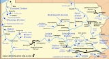
The Beaver and Erie Canal, also known as the Erie Extension Canal, was part of the Pennsylvania Canal
system and consisted of three sections: the Beaver Division, the Shenango Division, and the Conneaut Division. The canal ran 136 miles (219 km) north–south near the western edge of the state from the Ohio River
to Lake Erie
through Beaver County
, Lawrence County
, Mercer County
, Crawford County
, and Erie County, Pennsylvania
.
The southern terminus of the canal was the confluence of the Beaver River
with the Ohio River in Beaver County about 20 miles (32 km) downstream from Pittsburgh
, and the northern terminus was the city of Erie
, in Erie County. The canal needed a total of 137 locks
to overcome a change in elevation of 977 feet (298 m).
through northwestern Pennsylvania that would connect Lake Erie with the Ohio River; the Main Line of Public Works
, a canal which joined Philadelphia to Pittsburgh
; and the Erie Canal
, which connected Albany, New York
, to Lake Erie.
The Beaver Division, begun in 1831, extended 31 miles (50 km) from Beaver
along the Beaver River and the Shenango River
to Pulaski
. In 1836, work began on the Shenango Division extension of 61 miles (98.2 km) from Pulaski to Conneaut Lake
, and in 1838 contracts were awarded for the Conneaut Division to Erie, 45 miles (72.4 km) further north. Taking over the Conneaut Division from the state in 1843, the Erie Canal Company finished construction in 1844, when the entire length of the three divisions became open to traffic.
Two east–west canals connected to the Beaver and Erie. New Castle
, which the Beaver and Erie served, was the eastern terminus of Pennsylvania and Ohio Canal
, which ran 91 miles (146.4 km) west to the Ohio and Erie Canal
in Ohio. Another east–west canal, the French Creek Feeder, brought additional water into Conneaut Lake at the same time it provided a transportation corridor. It ran 25 miles (40.2 km) from near Meadville
, where it connected with the Franklin Line canal of 22 miles (35.4 km) running along French Creek to Franklin. At its southern terminus near Beaver, the Beaver and Erie was linked by the Ohio River to Pittsburgh and the principal east-west Pennsylvania transportation system of the time, the Main Line of Public Works
.
Bringing new business to communities such as Conneautville
, which shipped timber and hay to Pittsburgh, the Beaver and Erie Canal was heavily used in its early years but was hard to maintain. Competition from railroads and the collapse of an aqueduct
over Elk Creek in Erie County
led to the canal's abandonment in 1872.
Lake near Hermitage
. Well-preserved remains of Lock Number 10 are found in Sharpsville
, about a 0.5 mile (0.80467 km) south of the Shenango Dam. Maintained for hiking, the Shenango Trail follows the old canal towpath
. It runs about 8 miles (13 km) along the east side of the Shenango River from Kidd's Mill Covered Bridge to the confluence of Lackawannock Creek and the river. Canal artifacts and a replica of a canal boat, the Rufus S. Reed, are on display at the Greenville Canal Museum in Greenville
, on the Shenango River 72 miles (115.9 km) northwest of Pittsburgh. Some canal facilities at Bridgewater
, at the canal's southern end, remain; they are a part of the Bridgewater Historic District
.
. Water from the dam pool, at a higher elevation than the lake, flowed south through Meadville. It crossed French Creek by aqueduct at Shaw’s Landing, where locks enabled boats to transfer between the canal and the creek. Beyond the landing, the canal turned northwest and flowed into the lake. Engineering on these projects included raising the Conneaut Lake dam by 11 feet (3.4 m) and adding another short canal to carry water to a pumping station for the Beaver and Erie. The French Creek Feeder was completed to Meadville in 1828 and reached Conneaut Lake in 1834.
After the Beaver and Erie Canal was abandoned, the dam at Conneaut Lake was lowered. Also abandoned was the French Creek Feeder, though for a while it still flowed through Meadville. The Crawford County Historical Society has preserved a small part of the feeder canal.
. Merchants there, concerned that the feeder canal and the main canal would divert business from Franklin, persuaded the state to build a system of locks and dams on French Creek below Shaw’s Landing at Meadville. This canal, the Franklin Line, opened in 1833. Although the Franklin Line made it easier for boats to travel between Franklin and Meadville, it made it harder for rafts, which depended on river currents and were too big for the locks. Large boats also had trouble with the locks, and the creek often lacked sufficient water to carry them. In 1837, high water caused severe damage to the short-lived system, which was allowed to decline.
of 3 miles (4.8 km) through what later became Pymatuning State Park at Hartstown, Pennsylvania
. The causeway was built through Pymatuning Swamp
by the Erie Canal Company, effectively forming the 600 acres (2.4 km²) of Pymatuning Reservoir to the west of the canal.
Pennsylvania Canal
Pennsylvania Canal refers generally to a complex system of canals, dams, locks, tow paths, aqueducts, and other infrastructure including, in some cases, railroads in Pennsylvania...
system and consisted of three sections: the Beaver Division, the Shenango Division, and the Conneaut Division. The canal ran 136 miles (219 km) north–south near the western edge of the state from the Ohio River
Ohio River
The Ohio River is the largest tributary, by volume, of the Mississippi River. At the confluence, the Ohio is even bigger than the Mississippi and, thus, is hydrologically the main stream of the whole river system, including the Allegheny River further upstream...
to Lake Erie
Lake Erie
Lake Erie is the fourth largest lake of the five Great Lakes in North America, and the tenth largest globally. It is the southernmost, shallowest, and smallest by volume of the Great Lakes and therefore also has the shortest average water residence time. It is bounded on the north by the...
through Beaver County
Beaver County, Pennsylvania
-Demographics:As of the census of 2000, there were 181,412 people, 72,576 households, and 50,512 families residing in the county. The population density was 418 people per square mile . There were 77,765 housing units at an average density of 179 per square mile...
, Lawrence County
Lawrence County, Pennsylvania
Lawrence County is a county located in the U.S. state of Pennsylvania. In 2010, its population was 91,108. The county was added to the Pittsburgh Metropolitan Statistical Area in 2003. The county seat is New Castle....
, Mercer County
Mercer County, Pennsylvania
Mercer County is a county located in the U.S. state of Pennsylvania. As of 2010, the population was 116,638. Its county seat is Mercer; Sharon is its largest city....
, Crawford County
Crawford County, Pennsylvania
Crawford County is a county located in the U.S. state of Pennsylvania. As of 2010, the population was 88,765.Crawford County was created on March 12, 1800, from part of Allegheny County and named for Colonel William Crawford...
, and Erie County, Pennsylvania
Erie County, Pennsylvania
Erie County is a county located in the U.S. state of Pennsylvania. As of 2010, the population was 280,566. Its county seat is the City of Erie.- Geography :...
.
The southern terminus of the canal was the confluence of the Beaver River
Beaver River (Pennsylvania)
The Beaver River is a tributary of the Ohio River in Western Pennsylvania in the United States with a length of approximately 21 mi . It flows through a historically important coal-producing region north of Pittsburgh...
with the Ohio River in Beaver County about 20 miles (32 km) downstream from Pittsburgh
Pittsburgh, Pennsylvania
Pittsburgh is the second-largest city in the US Commonwealth of Pennsylvania and the county seat of Allegheny County. Regionally, it anchors the largest urban area of Appalachia and the Ohio River Valley, and nationally, it is the 22nd-largest urban area in the United States...
, and the northern terminus was the city of Erie
Erie, Pennsylvania
Erie is a city located in northwestern Pennsylvania in the United States. Named for the lake and the Native American tribe that resided along its southern shore, Erie is the state's fourth-largest city , with a population of 102,000...
, in Erie County. The canal needed a total of 137 locks
Lock (water transport)
A lock is a device for raising and lowering boats between stretches of water of different levels on river and canal waterways. The distinguishing feature of a lock is a fixed chamber in which the water level can be varied; whereas in a caisson lock, a boat lift, or on a canal inclined plane, it is...
to overcome a change in elevation of 977 feet (298 m).
History
Construction of the canal was meant to complete a transport networkTransport network
A transport network, or transportation network in American English, is typically a network of roads, streets, pipes, aqueducts, power lines, or nearly any structure which permits either vehicular movement or flow of some commodity....
through northwestern Pennsylvania that would connect Lake Erie with the Ohio River; the Main Line of Public Works
Main Line of Public Works
The Main Line of Public Works was a railroad and canal system built by the Commonwealth of Pennsylvania in the 19th century. It ran from Philadelphia west through Harrisburg and across the state to Pittsburgh and connected with other divisions of the Pennsylvania Canal...
, a canal which joined Philadelphia to Pittsburgh
Pittsburgh, Pennsylvania
Pittsburgh is the second-largest city in the US Commonwealth of Pennsylvania and the county seat of Allegheny County. Regionally, it anchors the largest urban area of Appalachia and the Ohio River Valley, and nationally, it is the 22nd-largest urban area in the United States...
; and the Erie Canal
Erie Canal
The Erie Canal is a waterway in New York that runs about from Albany, New York, on the Hudson River to Buffalo, New York, at Lake Erie, completing a navigable water route from the Atlantic Ocean to the Great Lakes. The canal contains 36 locks and encompasses a total elevation differential of...
, which connected Albany, New York
Albany, New York
Albany is the capital city of the U.S. state of New York, the seat of Albany County, and the central city of New York's Capital District. Roughly north of New York City, Albany sits on the west bank of the Hudson River, about south of its confluence with the Mohawk River...
, to Lake Erie.
The Beaver Division, begun in 1831, extended 31 miles (50 km) from Beaver
Beaver, Pennsylvania
Beaver is a borough in and the county seat of Beaver County, Pennsylvania, United States, at the confluence of the Beaver and Ohio Rivers. As of the 2000 census, the borough population was 4,775, having dropped from 5,641 in 1940....
along the Beaver River and the Shenango River
Shenango River
The Shenango River is a principal tributary of the Beaver River, approximately 100 mi long, in western Pennsylvania in the United States. It also briefly flows through small portions of northeastern Ohio...
to Pulaski
Pulaski Township, Beaver County, Pennsylvania
Pulaski Township is a township in Beaver County, Pennsylvania, United States. The population was 1,674 at the 2000 census.-Geography:According to the United States Census Bureau, the township has a total area of 0.8 square miles , all of it land.-Demographics:As of the census of 2000, there...
. In 1836, work began on the Shenango Division extension of 61 miles (98.2 km) from Pulaski to Conneaut Lake
Conneaut Lake
Conneaut Lake is the largest natural lake in Pennsylvania. It is located in western Crawford County near a town with the same name. During the summer season, it is heavily populated with people vacationing to the lake area, some from the area spending time in their houses on the lake, and many...
, and in 1838 contracts were awarded for the Conneaut Division to Erie, 45 miles (72.4 km) further north. Taking over the Conneaut Division from the state in 1843, the Erie Canal Company finished construction in 1844, when the entire length of the three divisions became open to traffic.
Two east–west canals connected to the Beaver and Erie. New Castle
New Castle, Pennsylvania
New Castle is a city in Lawrence County, Pennsylvania, United States, northwest of Pittsburgh and near the Pennsylvania-Ohio border just east of Youngstown, Ohio; in 1910, the total population was 36,280; in 1920, 44,938; and in 1940, 47,638. The population has fallen to 26,309 according to the...
, which the Beaver and Erie served, was the eastern terminus of Pennsylvania and Ohio Canal
Pennsylvania and Ohio Canal
The Pennsylvania and Ohio Canal, also known as the P & O Canal, the Cross Cut Canal and the Mahoning Canal was a shipping canal which operated from 1840 until 1877...
, which ran 91 miles (146.4 km) west to the Ohio and Erie Canal
Ohio and Erie Canal
The Ohio Canal or Ohio and Erie Canal was a canal constructed in the 1820s and early 1830s. It connected Akron, Summit County, with the Cuyahoga River near its mouth on Lake Erie in Cleveland, Cuyahoga County, and a few years later, with the Ohio River near Portsmouth, Scioto County, and then...
in Ohio. Another east–west canal, the French Creek Feeder, brought additional water into Conneaut Lake at the same time it provided a transportation corridor. It ran 25 miles (40.2 km) from near Meadville
Meadville, Pennsylvania
Meadville is a city in and the county seat of Crawford County, Pennsylvania, United States. The city is generally considered part of the Pittsburgh Tri-State and is within 40 miles of Erie, Pennsylvania. It was the first permanent settlement in northwest Pennsylvania...
, where it connected with the Franklin Line canal of 22 miles (35.4 km) running along French Creek to Franklin. At its southern terminus near Beaver, the Beaver and Erie was linked by the Ohio River to Pittsburgh and the principal east-west Pennsylvania transportation system of the time, the Main Line of Public Works
Main Line of Public Works
The Main Line of Public Works was a railroad and canal system built by the Commonwealth of Pennsylvania in the 19th century. It ran from Philadelphia west through Harrisburg and across the state to Pittsburgh and connected with other divisions of the Pennsylvania Canal...
.
Bringing new business to communities such as Conneautville
Conneautville, Pennsylvania
Conneautville is a borough in Crawford County, Pennsylvania, along Conneaut Creek. The population was 848 at the 2000 census.- History:Conneautville was founded in 1814 by Alexander Power, a surveyor and engineer. Conneautville was first called Powerstown or made reference to as Power’s Tract...
, which shipped timber and hay to Pittsburgh, the Beaver and Erie Canal was heavily used in its early years but was hard to maintain. Competition from railroads and the collapse of an aqueduct
Aqueduct
An aqueduct is a water supply or navigable channel constructed to convey water. In modern engineering, the term is used for any system of pipes, ditches, canals, tunnels, and other structures used for this purpose....
over Elk Creek in Erie County
Erie County, Pennsylvania
Erie County is a county located in the U.S. state of Pennsylvania. As of 2010, the population was 280,566. Its county seat is the City of Erie.- Geography :...
led to the canal's abandonment in 1872.
Remnants
Canal sections exist near Shenango RiverShenango River
The Shenango River is a principal tributary of the Beaver River, approximately 100 mi long, in western Pennsylvania in the United States. It also briefly flows through small portions of northeastern Ohio...
Lake near Hermitage
Hermitage, Pennsylvania
Hermitage is a city in Mercer County, Pennsylvania, United States. The population was 16,157 at the 2000 census. It is part of the Youngstown–Warren–Boardman, OH-PA Metropolitan Statistical Area.-History:...
. Well-preserved remains of Lock Number 10 are found in Sharpsville
Sharpsville, Pennsylvania
Sharpsville is a borough in Mercer County, Pennsylvania, along the Shenango River. The population was 4,500 at the 2000 census. It is part of the Youngstown–Warren–Boardman, OH-PA Metropolitan Statistical Area.-Geography:...
, about a 0.5 mile (0.80467 km) south of the Shenango Dam. Maintained for hiking, the Shenango Trail follows the old canal towpath
Towpath
A towpath is a road or trail on the bank of a river, canal, or other inland waterway. The purpose of a towpath is to allow a land vehicle, beasts of burden, or a team of human pullers to tow a boat, often a barge...
. It runs about 8 miles (13 km) along the east side of the Shenango River from Kidd's Mill Covered Bridge to the confluence of Lackawannock Creek and the river. Canal artifacts and a replica of a canal boat, the Rufus S. Reed, are on display at the Greenville Canal Museum in Greenville
Greenville, Pennsylvania
Greenville is a borough in Mercer County, Pennsylvania. Located along the Shenango River, Greenville is roughly 80 miles from both Pittsburgh and Cleveland. Greenville is part of the Youngstown–Warren–Boardman, OH-PA Metropolitan Statistical Area, which is home to 570,000 people...
, on the Shenango River 72 miles (115.9 km) northwest of Pittsburgh. Some canal facilities at Bridgewater
Bridgewater, Pennsylvania
Bridgewater is a borough in Beaver County, Pennsylvania, United States. The population was 739 at the 2000 census. It is best known as the home of the Bruster's Ice Cream chain. A few scenes in the 1986 movie Gung Ho were also shot in Bridgewater...
, at the canal's southern end, remain; they are a part of the Bridgewater Historic District
Bridgewater Historic District (Bridgewater, Pennsylvania)
The Bridgewater Historic District is a historic district in Bridgewater, Pennsylvania, United States. Listed on the National Register of Historic Places on June 28, 1996, it includes buildings built between 1818 and 1933, although the most significant buildings in the district are those that were...
.
French Creek Feeder
Because Conneaut Lake, fed mainly by springs and small streams, did not have enough water to keep the Beaver and Erie Canal filled at its highest elevation, the state built a feeder canal. The French Creek Feeder, as it was called, ran from a dam built for the purpose on the Bemus farm, 2 miles (3 km) north of MeadvilleMeadville, Pennsylvania
Meadville is a city in and the county seat of Crawford County, Pennsylvania, United States. The city is generally considered part of the Pittsburgh Tri-State and is within 40 miles of Erie, Pennsylvania. It was the first permanent settlement in northwest Pennsylvania...
. Water from the dam pool, at a higher elevation than the lake, flowed south through Meadville. It crossed French Creek by aqueduct at Shaw’s Landing, where locks enabled boats to transfer between the canal and the creek. Beyond the landing, the canal turned northwest and flowed into the lake. Engineering on these projects included raising the Conneaut Lake dam by 11 feet (3.4 m) and adding another short canal to carry water to a pumping station for the Beaver and Erie. The French Creek Feeder was completed to Meadville in 1828 and reached Conneaut Lake in 1834.
After the Beaver and Erie Canal was abandoned, the dam at Conneaut Lake was lowered. Also abandoned was the French Creek Feeder, though for a while it still flowed through Meadville. The Crawford County Historical Society has preserved a small part of the feeder canal.
Franklin Line
Downstream from Meadville lay the town of Franklin at the confluence of French Creek with the Allegheny RiverAllegheny River
The Allegheny River is a principal tributary of the Ohio River; it is located in the Eastern United States. The Allegheny River joins with the Monongahela River to form the Ohio River at the "Point" of Point State Park in Downtown Pittsburgh, Pennsylvania...
. Merchants there, concerned that the feeder canal and the main canal would divert business from Franklin, persuaded the state to build a system of locks and dams on French Creek below Shaw’s Landing at Meadville. This canal, the Franklin Line, opened in 1833. Although the Franklin Line made it easier for boats to travel between Franklin and Meadville, it made it harder for rafts, which depended on river currents and were too big for the locks. Large boats also had trouble with the locks, and the creek often lacked sufficient water to carry them. In 1837, high water caused severe damage to the short-lived system, which was allowed to decline.
Pymatuning Swamp
The canal passed along a causewayCauseway
In modern usage, a causeway is a road or railway elevated, usually across a broad body of water or wetland.- Etymology :When first used, the word appeared in a form such as “causey way” making clear its derivation from the earlier form “causey”. This word seems to have come from the same source by...
of 3 miles (4.8 km) through what later became Pymatuning State Park at Hartstown, Pennsylvania
Hartstown, Pennsylvania
Hartstown is a census-designated place in Crawford County, Pennsylvania, United States. The population was 246 at the 2000 census.-Geography:Hartstown is located at ....
. The causeway was built through Pymatuning Swamp
Pymatuning Reservoir
Pymatuning Reservoir is a man-made lake in Crawford County, Pennsylvania and Ashtabula County, Ohio in the United States, on land that was once a very large swamp. Much of it is incorporated into two state parks: Pymatuning State Park in Pennsylvania, and Pymatuning State Park in Ohio.-History:The...
by the Erie Canal Company, effectively forming the 600 acres (2.4 km²) of Pymatuning Reservoir to the west of the canal.
Points of interest
| Feature | Coordinates | Description |
|---|---|---|
| Erie Erie, Pennsylvania Erie is a city located in northwestern Pennsylvania in the United States. Named for the lake and the Native American tribe that resided along its southern shore, Erie is the state's fourth-largest city , with a population of 102,000... |
42°07′57"N 80°04′26"W | City at the northern terminus of the Beaver and Erie Canal |
| Greenville Greenville, Pennsylvania Greenville is a borough in Mercer County, Pennsylvania. Located along the Shenango River, Greenville is roughly 80 miles from both Pittsburgh and Cleveland. Greenville is part of the Youngstown–Warren–Boardman, OH-PA Metropolitan Statistical Area, which is home to 570,000 people... |
41°24′16"N 80°23′28"W | City near the mid-point of the Beaver and Erie Canal |
| New Castle New Castle, Pennsylvania New Castle is a city in Lawrence County, Pennsylvania, United States, northwest of Pittsburgh and near the Pennsylvania-Ohio border just east of Youngstown, Ohio; in 1910, the total population was 36,280; in 1920, 44,938; and in 1940, 47,638. The population has fallen to 26,309 according to the... |
40°59′39"N 80°20′02"W | City at the eastern terminus of the Pennsylvania and Ohio Canal |
| Beaver River Beaver River (Pennsylvania) The Beaver River is a tributary of the Ohio River in Western Pennsylvania in the United States with a length of approximately 21 mi . It flows through a historically important coal-producing region north of Pittsburgh... mouth |
40°41′49"N 80°17′21"W | Southern terminus of the Beaver and Erie Canal |
| Meadville Meadville, Pennsylvania Meadville is a city in and the county seat of Crawford County, Pennsylvania, United States. The city is generally considered part of the Pittsburgh Tri-State and is within 40 miles of Erie, Pennsylvania. It was the first permanent settlement in northwest Pennsylvania... |
41°38′29"N 80°09′05"W | City on the French Creek Feeder; northern terminus of the Franklin Line |
| Franklin | 41°23′52"N 79°49′53"W | City at the southern terminus of the Franklin Line |
External links
- American Folklife Center, Library of Congress
- http://www.topoquest.com/map.asp?lon=-80.3672&lat=41.5192USGS topographical map at Conneaut LakeConneaut Lake, PennsylvaniaConneaut Lake is a borough in Crawford County, Pennsylvania at the southern end of a lake with the same name. The population was 708 at the 2000 census.-History:...
, TopoQuest] - Erie Extension Canal: Conneaut Division, Conneaut Valley Area Historical Society (CVAHS)
- Pennsylvania Canal Society
- American Canal Society
- National Canal Museum