
List of National Natural Landmarks in Indiana
Encyclopedia
From List of National Natural Landmarks, these are the National Natural Landmark
s in Indiana
.
National Natural Landmark
The National Natural Landmark program recognizes and encourages the conservation of outstanding examples of the natural history of the United States. It is the only natural areas program of national scope that identifies and recognizes the best examples of biological and geological features in...
s in Indiana
Indiana
Indiana is a US state, admitted to the United States as the 19th on December 11, 1816. It is located in the Midwestern United States and Great Lakes Region. With 6,483,802 residents, the state is ranked 15th in population and 16th in population density. Indiana is ranked 38th in land area and is...
.
| Name | Image | Date | Location | County | Description | |
|---|---|---|---|---|---|---|
| 1 | Big Walnut Creek | Putnam Putnam County, Indiana As of the census of 2000, there were 36,019 people, 12,374 households, and 9,119 families residing in the county. The population density was 75 people per square mile . There were 13,505 housing units at an average density of 28 per square mile... |
Contains one of the few stands in Indiana where beech, sugar maple, and tulip poplar grow on alluvial Genesee soil. | |||
| 2 | Cabin Creek Raised Bog | Randolph Randolph County, Indiana Randolph County is a county located in the U.S. state of Indiana. As of 2010, the population was 26,171. The county seat is Winchester.-History:... |
A fen that supports a very rich flora. | |||
| 3 | Calvert and Porter Woods | Montgomery Montgomery County, Indiana Montgomery County is a county located in the U.S. state of Indiana. As of 2010, the population was 38,124. The county seat is Crawfordsville-Early history and settlement:... |
One of the finest near-virgin remnant forests in the Tipton Till Plain of central Indiana. | |||
| 4 | Cowles Bog Cowles Bog Cowles Bog is named for Henry Chandler Cowles of the University of Chicago. Dr. Cowles is credited with the creation of the concept of Ecology. It was here at Cowles Bog that Dr. Cowles did his pioneering work. The bog is a National Natural Landmark. Cowles Bog is more than 8,000 years old and... |
Porter Porter County, Indiana Porter County is a county located in the U.S. state of Indiana. As of 2010, the population was 164,343. Much of the population growth has to do with the expansion of the Chicago Metropolitan Area eastward into Indiana. The county seat is Valparaiso... |
Indiana Dunes National Lakeshore Indiana Dunes National Lakeshore Indiana Dunes National Lakeshore is a U.S. National Lakeshore located in northwest Indiana and managed by the National Park Service. It was authorized by Congress in 1966. The national lakeshore runs for nearly along the southern shore of Lake Michigan, from Gary, Indiana, on the west to Michigan... -Cowles Bog is the sole remaining remnant of the Central Dunes where Henry Chandler Cowles Henry Chandler Cowles Henry Chandler Cowles was an American botanist and ecological pioneer . Born in Kensington, Connecticut, he attended Oberlin College in Ohio. He studied at the University of Chicago with the plant taxonomist John M. Coulter and the geologist Thomas Chrowder Chamberlin as main teachers. He... performed his pioneering field studies of plant succession and species diversity. |
|||
| 5 | Davis-Purdue Agriculture Center Forest | Randolph Randolph County, Indiana Randolph County is a county located in the U.S. state of Indiana. As of 2010, the population was 26,171. The county seat is Winchester.-History:... |
The best old growth oak-hickory forest Oak-hickory forest The oak-hickory forest is a general type of North American forest ecosystem with a range extending from southern New England and New York, west to Iowa, and south to Northern Georgia. Smaller, isolated Oak-Hickory communities can also be found as far west as North Dakota, south to Florida and... on the Tipton Till Plain. |
|||
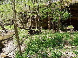
| 6 | Donaldson Cave System and Woods | Lawrence Lawrence County, Indiana As of the census of 2000, there were 45,922 people, 18,535 households, and 13,141 families residing in the county. The population density was 102 people per square mile . There were 20,560 housing units at an average density of 46 per square mile... |
Spring Mill State Park Spring Mill State Park Spring Mill State Park is a state park in the state of Indiana. The park is located to the south of Bloomington, about east of the town of Mitchell on Indiana Highway 60.... -A stream flows from a cave through the bottom of a gorge. |
|||
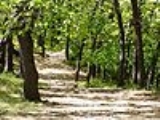
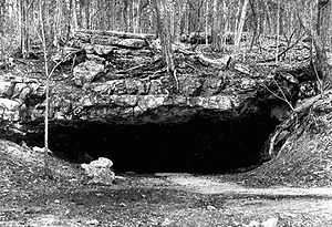
| 7 | Dunes Nature Preserve | 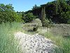 |
Porter Porter, Indiana Porter is a town in Westchester Township, Porter County, Indiana, United States. The population was 4,972 at the 2000 census.Porter is noted for its proximity to the Indiana Dunes State Park and for its railroad heritage... 41.66°N 87.04°W |
Porter Porter County, Indiana Porter County is a county located in the U.S. state of Indiana. As of 2010, the population was 164,343. Much of the population growth has to do with the expansion of the Chicago Metropolitan Area eastward into Indiana. The county seat is Valparaiso... |
Indiana Dunes State Park Indiana Dunes State Park Indiana DunesDesignationState Park; National Natural LandmarkLocationPorter County, Indiana, USAAddress1600 N 25 EChesterton, IN 46304Nearest CityPorter, IndianaCoordinatesAreaDate of Establishment1925... -Inter-dunal wetlands and blowouts Blowout (geology) Blowouts are sandy depressions in a sand dune ecosystem caused by the removal of sediments by wind.Blowouts occur in partially vegetated dunefields or sandhills. A blowout forms when a patch of protective vegetation is lost, allowing strong winds to "blow out" sand and form a depression... along Lake Michigan Lake Michigan Lake Michigan is one of the five Great Lakes of North America and the only one located entirely within the United States. It is the second largest of the Great Lakes by volume and the third largest by surface area, after Lake Superior and Lake Huron... |
|
| 8 | Fern Cliff | Putnam Putnam County, Indiana As of the census of 2000, there were 36,019 people, 12,374 households, and 9,119 families residing in the county. The population density was 75 people per square mile . There were 13,505 housing units at an average density of 28 per square mile... |
Contains exceptional occurrences of mosses and liverworts, including a noteworthy number of rare species. | |||
| 9 | Hanging Rock Hanging Rock National Natural Landmark Hanging Rock National Natural Landmark is a site in Wabash County, Indiana that was designated a National Natural Landmark in May, 1986. The site, located on the southern bank of the Wabash River near the town of Lagro, contains an impressive natural exposure of fossilized coral reef dating from... and Wabash Reef |
Wabash Wabash County, Indiana As of the census of 2000, there were 34,960 people, 13,215 households, and 9,395 families residing in the county. The population density was 85 people per square mile . There were 14,034 housing units at an average density of 34 per square mile... |
Contains an impressive natural exposure of fossilized coral reef dating from the Silurian Period some 400 million years ago. The limestone reef deposit rises 75 feet (23 m) above the river and is being undercut by it, giving the site its "hanging" appearance. | |||
| 10 | Harrison Spring Harrison Spring Harrison Spring is the name of the largest spring in the state of Indiana. It is located in west-central Harrison County, near the Blue River and just north of White Cloud.-The Spring:... |
 |
Harrison Harrison County, Indiana Harrison County is a county located in the far southern part of the U.S. state of Indiana along the Ohio River. It is divided into twelve townships, and the county seat is Corydon, the former capital of Indiana. The county is part of the larger Louisville/Jefferson County, KY–IN Metropolitan... |
A portion of the water that feeds the spring originates from Indian Creek, and then goes underground until it reaches the spring area. It produces at least 3 million gallons of water a day at an average of 18,000 gpm, enough to supply water to an average town of 12,000 | ||
| 11 | Hemmer Woods | Gibson Gibson County, Indiana Gibson County is a county located in the southwestern part of the U.S. state of Indiana and is included in the Evansville, Indiana–Kentucky Metropolitan Statistical Area. As of 2010, the population was 33,503. The county seat is Princeton.-Geography:... |
Original southwestern Indiana oak-hickory forest. | |||
| 12 | Hoosier Prairie | Lake Lake County, Indiana Lake County is a county located in the U.S. state of Indiana. In 2010, its population was 496,005, making it Indiana's second-most populous county. The county seat is Crown Point. This county is part of Northwest Indiana and the Chicago metropolitan area. The county contains a mix of urban,... |
Indiana Dunes National Lakeshore Indiana Dunes National Lakeshore Indiana Dunes National Lakeshore is a U.S. National Lakeshore located in northwest Indiana and managed by the National Park Service. It was authorized by Congress in 1966. The national lakeshore runs for nearly along the southern shore of Lake Michigan, from Gary, Indiana, on the west to Michigan... - Wetland prairie remnant of sand plains, sedge Sweet Flag Acorus calamus, commonly known as Sweet Flag or Calamus and erroneously as "rush" or "sedges", is a plant from the Acoraceae family, in the genus Acorus. It is a tall perennial wetland monocot with scented leaves and more strongly scented rhizomes... meadows, and marsh Marsh In geography, a marsh, or morass, is a type of wetland that is subject to frequent or continuous flood. Typically the water is shallow and features grasses, rushes, reeds, typhas, sedges, other herbaceous plants, and moss.... es. |
|||
| 13 | Hoot Woods | Owen Owen County, Indiana Owen County is a county located in the U.S. state of Indiana, and determined by the U.S. Census Bureau to include the mean center of U.S. population in 1920. As of 2010, the population was 21,575... |
A relatively undisturbed, isolated beech-maple forest in which near climax conditions prevails. | |||
| 14 | Kramer Woods | Indiana | ||||
| 15 | Marengo Cave Marengo Cave Marengo Cave is located in Marengo, Indiana. One of only four show caves in Indiana, public tours of the cave have been given since 1883. Tours commenced just days after the cave's discovery by two school children.-The Discovery:... |
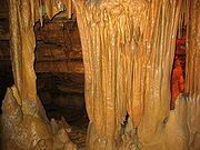 |
Crawford Crawford County, Indiana Crawford County is a county located in the U.S. state of Indiana. As of 2010, the population was 10,713. The county seat is English.-Geography:... |
One of only four show caves in Indiana, public tours of the cave have been given since 1883. Tours commenced just days after the cave's discovery by two school children. | ||
| 16 | Meltzer Woods Meltzer Woods Meltzer Woods consists of of old-growth forest located in Central Indiana. The woods have been included in Indiana's Classified Forest Program since 1928... |
Shelby Shelby County, Indiana As of the census of 2000, there were 43,445 people, 16,561 households, and 12,056 families residing in the county. The population density was 105 people per square mile . There were 17,633 housing units at an average density of 43 per square mile... |
Contains two contrasting forest types and exceptionally large individuals of several tree species. | |||
| 17 | Officer's Woods | Jefferson Jefferson County, Indiana Jefferson County is a county located in the U.S. state of Indiana. As of 2010, the population was 32,428. The county seat is Madison.-History:Jefferson County was formed in 1811... |
One of the finest remnants of beech-maple forest south of the Wisconsin-age glacial boundary in Indiana. | |||
| 18 | Ohio Coral Reef | Floyd Floyd County, Indiana Floyd County is a county located in the U.S. state of Indiana. As of 2010, the population was 74,578. The county seat is New Albany. Floyd County is the county with the second smallest land area in the entire state... |
A classic example of a Silurian Silurian The Silurian is a geologic period and system that extends from the end of the Ordovician Period, about 443.7 ± 1.5 Mya , to the beginning of the Devonian Period, about 416.0 ± 2.8 Mya . As with other geologic periods, the rock beds that define the period's start and end are well identified, but the... and Devonian Devonian The Devonian is a geologic period and system of the Paleozoic Era spanning from the end of the Silurian Period, about 416.0 ± 2.8 Mya , to the beginning of the Carboniferous Period, about 359.2 ± 2.5 Mya... coral community. Extends into Kentucky. |
|||
| 19 | Pine Hills Natural Area | Montgomery Montgomery County, Indiana Montgomery County is a county located in the U.S. state of Indiana. As of 2010, the population was 38,124. The county seat is Crawfordsville-Early history and settlement:... |
Shades State Park Shades State Park Shades State Park is a state park in Montgomery, Parke, and Fountain Counties in Indiana. It is located west-northwest of Indianapolis, Indiana. In the last decades of the 19th century, the area was a resort with a forty-room inn. In the 1930s a man named Joseph Frisz acquired the land in order... - Deep gorges, the result of the last glacial meltwaters. |
|||
| 20 | Pinhook Bog Pinhook Bog Indiana’s only true bog is a special geologic feature of this region which preserves a large variety of plants with extraordinary adaptations for survival. See insect eating plants and tamarack trees; walk on a boardwalk that is placed upon a floating mat of sphagnum moss. Pinhook Bog is about , a... |
LaPorte LaPorte County, Indiana LaPorte County is a county located in the U.S. state of Indiana. As of 2010, the population was 111,467. The county seat is the city of La Porte. This county is part of the Chicago metropolitan area, Northwest Indiana and Michiana. The largest city is Michigan City... |
Indiana Dunes National Lakeshore Indiana Dunes National Lakeshore Indiana Dunes National Lakeshore is a U.S. National Lakeshore located in northwest Indiana and managed by the National Park Service. It was authorized by Congress in 1966. The national lakeshore runs for nearly along the southern shore of Lake Michigan, from Gary, Indiana, on the west to Michigan... -bog formed from a postglacial kettle Kettle A kettle, sometimes called a tea kettle or teakettle, is a small kitchen appliance used for boiling water. Kettles can be heated either by placing on a stove, or by their own electric heating element.- Stovetop kettles :... moraine Moraine A moraine is any glacially formed accumulation of unconsolidated glacial debris which can occur in currently glaciated and formerly glaciated regions, such as those areas acted upon by a past glacial maximum. This debris may have been plucked off a valley floor as a glacier advanced or it may have... left behind about 14,000 years before the present by the melting of the ice sheet during the end of the Wisconsin glaciation. The acidic bog Bog A bog, quagmire or mire is a wetland that accumulates acidic peat, a deposit of dead plant material—often mosses or, in Arctic climates, lichens.... is noted for pitcher plants and other wetland Wetland A wetland is an area of land whose soil is saturated with water either permanently or seasonally. Wetlands are categorised by their characteristic vegetation, which is adapted to these unique soil conditions.... species. |
|||
| 21 | Pioneer Mother's Memorial Forest | Orange Orange County, Indiana As of the census of 2000, there were 19,306 people, 7,621 households, and 5,342 families residing in the county. The population density was 48 people per square mile . There were 8,348 housing units at an average density of 21 per square mile... |
One of the best examples of an original, undisturbed pre- settlement forest in Indiana. | |||
| 22 | Portland Arch Nature Preserve Portland Arch Nature Preserve Portland Arch Nature Preserve is a nature preserve near the Wabash River in Fountain County, Indiana, and is a National Natural Landmark. The preserve encompasses the wooded valleys, ravines and rocky cliffs around the lowest section of Bear Creek, which flows northwest toward the Wabash... |
 |
Fountain Fountain County, Indiana Fountain County lies in the western part of the U.S. state of Indiana on the east side of the Wabash River. The county was officially established in 1826 and was the 53rd in Indiana. The county seat is Covington.... |
The preserve encompasses the wooded valleys, ravines and rocky cliffs around the lowest section of Bear Creek. The name comes from a natural sandstone bridge carved by a small tributary of Bear Creek. | ||
| 23 | Rise at Orangeville Rise at Orangeville Orangeville Rise is the second largest spring in the U.S. state of Indiana, in Orange County near Orangeville. It was designated a National Natural Landmark in June 1972. Contrary to popular belief, the spring is not a rise of the Lost River which actually surfaces approximately south of Orangeville... |
Orange Orange County, Indiana As of the census of 2000, there were 19,306 people, 7,621 households, and 5,342 families residing in the county. The population density was 48 people per square mile . There were 8,348 housing units at an average density of 21 per square mile... |
Orangeville Rise of Lost River Nature Preserve is the second largest spring in the state of Indiana. | |||
| 24 | Rocky Hollow Falls Canyon Nature Preserve | Parke Parke County, Indiana Parke County is a county in the western part of the U.S. state of Indiana. It was formed in 1821 out of a portion of Vigo County. The county seat is Rockville.... |
Rocky Hollow and Falls Canyon are two of a series of canyons cut into the sandstone of Turkey Run. | |||
| 25 | Shrader-Weaver Woods | Fayette Fayette County, Indiana -2010 Census Data:As of the census of 2010, there were 24,277 people and 9,719 households residing in the county. The population density was 113 people per square mile . There were 10,898 housing units at an average density of 51 per square mile... |
Shrader-Weaver Nature Preserve - Old growth beech-maple forest with a pioneer homestead. Includes tulip Liriodendron Liriodendron is a genus of two species of characteristically large deciduous trees in the magnolia family .These trees are widely known by the common name tulip tree or tuliptree for their large flowers superficially resembling tulips, but are closely related to magnolias rather than lilies, the... , wild black cherry Black Cherry Prunus serotina, commonly called black cherry, wild black cherry, rum cherry, or mountain black cherry, is a woody plant species belonging to the genus Prunus... and black walnut Black Walnut Juglans nigra, the Eastern Black walnut, is a species of flowering tree in the hickory family, Juglandaceae, that is native to eastern North America. It grows mostly in riparian zones, from southern Ontario, west to southeast South Dakota, south to Georgia, northern Florida and southwest to central... trees. |
|||
| 26 | Tamarack Bog | LaGrange LaGrange County, Indiana LaGrange County is a county located in the U.S. state of Indiana and in the Northern Indiana region known as Michiana. As of 2010, the population was 37,128. The county is located about east of South Bend, west of Toledo, Ohio, and northeast of Indianapolis. The area is well known for its large... |
Tamarack Bog Nature Preserve, Pigeon River Fish and Wildlife Area - Large tamarack tree swamp | |||
| 27 | Tolliver Swallowhole | Orange Orange County, Indiana As of the census of 2000, there were 19,306 people, 7,621 households, and 5,342 families residing in the county. The population density was 48 people per square mile . There were 8,348 housing units at an average density of 21 per square mile... |
An extraordinary example of the disappearing stream aspect of karst topography. | |||
| 28 | Wesley Chapel Gulf | Orange Orange County, Indiana As of the census of 2000, there were 19,306 people, 7,621 households, and 5,342 families residing in the county. The population density was 48 people per square mile . There were 8,348 housing units at an average density of 21 per square mile... |
Probably the largest sinkhole in Indiana. | |||
| 29 | Wesselman Woods Nature Preserve Wesselman Woods Nature Preserve Wesselman Woods Nature Preserve is a nature preserve located in Evansville, Indiana. It is a National Natural Landmark and a State Nature Preserve owned by the City of Evansville and operated by the non-profit Wesselman Woods Nature Preserve Society.... |
Vanderburgh Vanderburgh County, Indiana As of the census of 2000, there were 171,922 people, 70,623 households, and 44,421 families residing in the county. The population density was 733 people per square mile . There were 76,300 housing units at an average density of 325 per square mile... |
Wesselman Woods Nature Preserve - southern old growth forest | |||
| 30 | Wyandotte Caves Wyandotte Caves Wyandotte Caves, a pair of limestone caves located on the Ohio River in Harrison-Crawford State Forest in Crawford County, five miles north-east of Leavenworth and 12 miles from Corydon in southern Indiana, is a popular tourist attraction. Wyandotte Caves were designated a National Natural... |
 |
Crawford Crawford County, Indiana Crawford County is a county located in the U.S. state of Indiana. As of 2010, the population was 10,713. The county seat is English.-Geography:... |
O'Bannon Woods State Park/Harrison-Crawford State Forest - Wyandotte caves began to form in the Pliocene Era, about 2 million years ago. Like most of Southern Indiana's caves, the caves were formed when water dissolved limestone, causing hollow caves to form. | ||