
List of National Historic Landmarks in New Mexico
Encyclopedia
This is a complete List of National Historic Landmarks in New Mexico. New Mexico has 44 National Historic Landmarks (NHLs), including Raton Pass
which is shared with Colorado, and listed by the National Park Service as in that state.
They are:
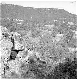
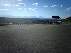
Raton Pass
Raton Pass is a mountain pass on the Santa Fe Trail along the Colorado-New Mexico border in the United States. Raton Pass is a federally designated National Historic Landmark...
which is shared with Colorado, and listed by the National Park Service as in that state.
Current NHLs
The NHLs are distributed across 22 of New Mexico's 33 counties.| Landmark name | Image | Year listed | Locality | County | Description | |
|---|---|---|---|---|---|---|
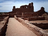
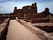
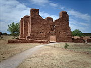
| Abo Abo (historic place) Abo is a pueblo ruin in New Mexico that is preserved in the Salinas Pueblo Missions National Monument.The Abó Ruins are located about 9 miles west of Mountainair, at about 6100 feet above sea level. They are said to date back to the 1300s. It was a major trading station during its time... |
 |
Abo Abo, New Mexico Abo is an unincorporated community in Torrance County, New Mexico, United States, located on U.S. Route 60. It is the nearest community to Abo, a pueblo ruin and mission ruin that is a National Historic Landmark.... |
Torrance Torrance County, New Mexico -2010:Whereas according to the 2010 U.S. Census Bureau:*76.1% White*1.3% Black*2.3% Native American*0.4% Asian*0.0% Native Hawaiian or Pacific Islander*4.3% Two or more races*15.6% Other races*39.1% Hispanic or Latino -2000:... |
Pueblo ruins, and ruins of a Spanish mission, Salinas Pueblo Missions National Monument Salinas Pueblo Missions National Monument The Salinas Pueblo Missions National Monument is located in the U.S. state of New Mexico, near Mountainair. The main park visitor center is in Mountainair.-History:... |
||
| Acoma Pueblo Acoma Pueblo Acoma Pueblo is a Native American pueblo approximately 60 miles west of Albuquerque, New Mexico in the United States. Three reservations make up Acoma Pueblo: Sky City , Acomita, and McCartys. The Acoma Pueblo tribe is a federally recognized tribal entity... |
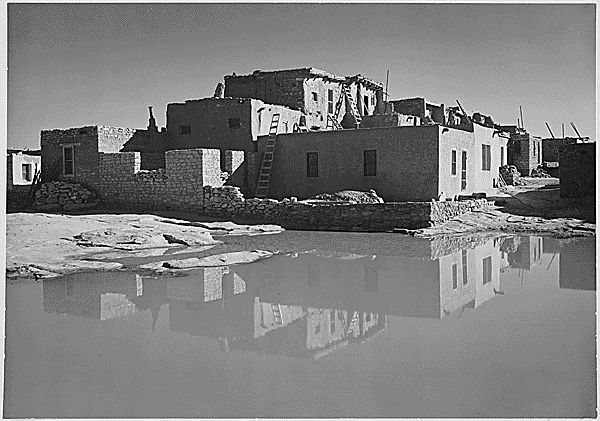 |
Acoma Pueblo Acoma Pueblo Acoma Pueblo is a Native American pueblo approximately 60 miles west of Albuquerque, New Mexico in the United States. Three reservations make up Acoma Pueblo: Sky City , Acomita, and McCartys. The Acoma Pueblo tribe is a federally recognized tribal entity... |
Cibola Cibola County, New Mexico -2010:Whereas according to the 2010 U.S. Census Bureau:*41.8% White*1.0% Black*41.0% Native American*0.5% Asian*0.1% Native Hawaiian or Pacific Islander*3.1% Two or more races*12.5% Other races*36.5% Hispanic or Latino -2000:... |
Native American pueblo built atop a 367-foot (112 m) sandstone mesa | ||
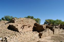
| Bandelier CCC Historic District Bandelier CCC Historic District Bandelier CCC Historic District, also known as Bandelier Buildings and Frijoles Canyon Lodge, is a historic district within Bandelier National Monument that preserves a set of architecturally significant park buildings.... |
Bandelier National Monument |
Los Alamos Los Alamos County, New Mexico -2010:Whereas according to the 2010 U.S. Census Bureau:*87.8% White*0.6% Black*0.8% Native American*6.0% Asian*0.0% Native Hawaiian or Pacific Islander*2.6% Two or more races*2.2% Other races*14.7% Hispanic or Latino -2000:... and Sandoval Sandoval County, New Mexico -Indian reservations:Sandoval County has 12 Indian reservations and two joint-use areas lying within its borders, the second most of any county in the United States -Indian reservations:Sandoval County has 12 Indian reservations and two joint-use areas lying within its borders, the second most of... |
Civilian Conservation Corps Civilian Conservation Corps The Civilian Conservation Corps was a public work relief program that operated from 1933 to 1942 in the United States for unemployed, unmarried men from relief families, ages 18–25. A part of the New Deal of President Franklin D... buildings |
|||
| Barrio De Analco Historic District Barrio De Analco Historic District Barrio de Analco Historic District is a historic district in Santa Fe, New Mexico that includes what are claimed to be the oldest house and the oldest church in the United States. It includes seven historic structures as well as other structures in between them. The name "Analco" comes from the... |
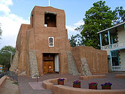 |
Santa Fe Santa Fe, New Mexico Santa Fe is the capital of the U.S. state of New Mexico. It is the fourth-largest city in the state and is the seat of . Santa Fe had a population of 67,947 in the 2010 census... |
Santa Fe Santa Fe County, New Mexico -2010:Whereas according to the 2010 U.S. Census Bureau:*76.2% White*0.9% Black*3.1% Native American*1.2% Asian*0.1% Native Hawaiian or Pacific Islander*3.6% Two or more races*14.9% Other races*50.6% Hispanic or Latino -2000:... |
Historic district including the oldest house and the oldest church in the United States | ||
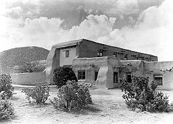
| Big Bead Mesa Big Bead Mesa Big Bead Mesa is a Navajo village site near Casa Salazar, New Mexico.It was declared a National Historic Landmark in 1964.... |
Casa Salazar |
Sandoval Sandoval County, New Mexico -Indian reservations:Sandoval County has 12 Indian reservations and two joint-use areas lying within its borders, the second most of any county in the United States -Indian reservations:Sandoval County has 12 Indian reservations and two joint-use areas lying within its borders, the second most of... |
Fortified Navajo village site; served as a base for trade and raiding from 1745 to 1812 | |||
| Blackwater Draw Blackwater Draw Blackwater Draw is a dry stream channel about long, heading in Curry County, New Mexico, about southwest of Texico, New Mexico and trending generally southeastward across the Llano Estacado to the city of Lubbock, Texas, where it joins Yellow House Draw to form Yellow House Canyon at the head of... |
Clovis Clovis, New Mexico Clovis is the county seat of Curry County, New Mexico, United States. Its population was 32,667 at the 2000 census; according to 2010 Census Bureau estimates, the population had risen to 37,775.... |
Roosevelt Roosevelt County, New Mexico -2010:Whereas according to the 2010 U.S. Census Bureau:*76.9% White*1.8% Black*1.3% Native American*0.9% Asian*0.0% Native Hawaiian or Pacific Islander*3.2% Two or more races*15.9% Other races*39.9% Hispanic or Latino -2000:... |
Archaeological type site Type site In archaeology a type site is a site that is considered the model of a particular archaeological culture... of the Clovis culture Clovis culture The Clovis culture is a prehistoric Paleo-Indian culture that first appears 11,500 RCYBP , at the end of the last glacial period, characterized by the manufacture of "Clovis points" and distinctive bone and ivory tools... |
|||
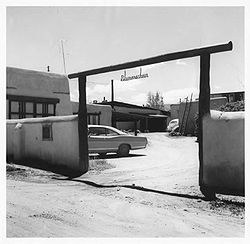
| Ernest L. Blumenschein House Ernest L. Blumenschein House Ernest L. Blumenschein House was a home of painter Ernest L. Blumenschein, a co-founder of the Taos Society of Artists and one of the "Taos Six".It was declared a National Historic Landmark in 1965.-E. L. Blumenschein Home and Museum:The historic E.L... |
 |
Taos Taos, New Mexico Taos is a town in Taos County in the north-central region of New Mexico, incorporated in 1934. As of the 2000 census, its population was 4,700. Other nearby communities include Ranchos de Taos, Cañon, Taos Canyon, Ranchitos, and El Prado. The town is close to Taos Pueblo, the Native American... 36.4039673°N 105.576137°W |
Taos Taos County, New Mexico -2010:Whereas according to the 2010 U.S. Census Bureau:*68.7% White*0.4% Black*6.2% Native American*0.7% Asian*0.0% Native Hawaiian or Pacific Islander*3.9% Two or more races*20.1% Other races*55.8% Hispanic or Latino -2000:... |
Home of painter Ernest L. Blumenschein Ernest L. Blumenschein Ernest Leonard Blumenschein was an American artist andfounding member of the Taos Society of Artists. He is noted for paintings of Native Americans, New Mexico and the American Southwest.-Early life and education:... , co-founder of Taos Art Colony |
||
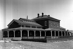
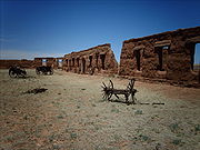
| Carlsbad Irrigation District Carlsbad Irrigation District Carlsbad Irrigation District, also known as Carlsbad Reclamation Project or Irrigation system of the Pecos Irrigation and Improvement Company, is a historic district near Carlsbad, New Mexico... |
.jpg) |
Carlsbad Carlsbad, New Mexico Carlsbad is a city in and the county seat of Eddy County, New Mexico, in the United States. As of the 2010 census, the city population was 26,138. Carlsbad is the center of the designated micropolitan area of Carlsbad-Artesia, which has a total population of 55,435... |
Eddy Eddy County, New Mexico -2010:Whereas according to the 2010 U.S. Census Bureau:*77.4% White*1.4% Black*1.5% Native American*0.7% Asian*0.0% Native Hawaiian or Pacific Islander*3.0% Two or more races*16.0% Other races*44.1% Hispanic or Latino -2000:... |
Irrigation-related dams, spillways, other structures | ||
| Kit Carson House Kit Carson House Kit Carson House was a home of frontiersman Kit Carson in Taos, New Mexico.It is operated now as a house museum.It was declared a National Historic Landmark in 1963.-External links:** at Historic American Building Survey... |
.jpg) |
Taos Taos, New Mexico Taos is a town in Taos County in the north-central region of New Mexico, incorporated in 1934. As of the 2000 census, its population was 4,700. Other nearby communities include Ranchos de Taos, Cañon, Taos Canyon, Ranchitos, and El Prado. The town is close to Taos Pueblo, the Native American... 36.405159°N 105.572131°W |
Taos Taos County, New Mexico -2010:Whereas according to the 2010 U.S. Census Bureau:*68.7% White*0.4% Black*6.2% Native American*0.7% Asian*0.0% Native Hawaiian or Pacific Islander*3.9% Two or more races*20.1% Other races*55.8% Hispanic or Latino -2000:... |
Home of frontiersman Kit Carson Kit Carson Christopher Houston "Kit" Carson was an American frontiersman and Indian fighter. Carson left home in rural present-day Missouri at age 16 and became a Mountain man and trapper in the West. Carson explored the west to California, and north through the Rocky Mountains. He lived among and married... |
||
| El Santuario De Chimayo El Santuario de Chimayo El Santuario de Chimayó is a Roman Catholic church in Chimayó, New Mexico, USA. This shrine, a National Historic Landmark, is famous for the story of its founding and as a contemporary pilgrimage site... |
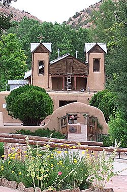 |
Chimayo Chimayo, New Mexico Chimayo is a census-designated place in Rio Arriba and Santa Fe Counties in the U.S. state of New Mexico; the community's name is more correctly pronounced and spelled Chimayó, a name that derives from a Tewa name for a local landmark, the hill of Tsi Mayoh... |
Santa Fe Santa Fe County, New Mexico -2010:Whereas according to the 2010 U.S. Census Bureau:*76.2% White*0.9% Black*3.1% Native American*1.2% Asian*0.1% Native Hawaiian or Pacific Islander*3.6% Two or more races*14.9% Other races*50.6% Hispanic or Latino -2000:... |
Roman Catholic church, famous for the story of its founding and as a contemporary pilgrimage site | ||
| Folsom Site Folsom Site Folsom Site , in Folsom, New Mexico, is the archaeological site that is the type site for the Folsom tradition, a Paleo-Indian cultural sequence dating to between 9000 BC and 8000 BC... |
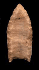 |
Folsom Folsom, New Mexico Folsom is a village in Union County, New Mexico, United States. The population was 75 at the 2000 census. The town was named after Frances Folsom, the fiancee of President Grover Cleveland.-Geography:Folsom is located at .... |
Colfax Colfax County, New Mexico -2010:Whereas according to the 2010 U.S. Census Bureau:*83.8% White*0.5% Black*1.5% Native American*0.4% Asian*0.1% Native Hawaiian or Pacific Islander*3.6% Two or more races*10.1% Other races*47.2% Hispanic or Latino -2000:... |
Archaeological site Archaeological site An archaeological site is a place in which evidence of past activity is preserved , and which has been, or may be, investigated using the discipline of archaeology and represents a part of the archaeological record.Beyond this, the definition and geographical extent of a 'site' can vary widely,... ; type site Type site In archaeology a type site is a site that is considered the model of a particular archaeological culture... for the Folsom tradition Folsom tradition The Folsom Complex is a name given by archaeologists to a specific Paleo-Indian archaeological culture that occupied much of central North America... |
||
| Fort Bayard Site Fort Bayard Historic District Fort Bayard Historic District, also known as Fort Bayard Site, near Santa Clara , New Mexico, was the site of an 1866 post of the US Army "Buffalo Soldiers".-History:... |
 |
Santa Clara Santa Clara, New Mexico Santa Clara is a village in Grant County, New Mexico, United States. The population was 3,944 at the 2000 census. Today a bedroom community for nearby Silver City, Santa Clara has experienced substantial growth in recent years.-Name:... |
Grant Grant County, New Mexico -2010:Whereas according to the 2010 U.S. Census Bureau:*84.9% White*0.9% Black*1.4% Native American*0.4% Asian*0.1% Native Hawaiian or Pacific Islander*2.8% Two or more races*9.8% Other races*48.3% Hispanic or Latino -2000:... |
Site of an 1866 post of Buffalo Soldiers | ||
| Glorieta Pass Battlefield Glorieta Pass Battlefield Glorieta Pass Battlefield, also known as Glorieta Pass, was the site of a decisive American Civil War battle that ended Confederate ambitions to cut off the West from the Union... |
 |
Pecos Pecos, New Mexico Pecos is a village in San Miguel County, New Mexico, United States. The population was 1,441 at the 2000 census, growing much faster than in other parts of San Miguel County, partly because Pecos is within commuting distance of Santa Fe. The village is built along the Pecos River which flows from... } |
San Miguel San Miguel County, New Mexico -2010:Whereas according to the 2010 U.S. Census Bureau:*66.6% White*1.4% Black*1.7% Native American*0.8% Asian*0.1% Native Hawaiian or Pacific Islander*3.9% Two or more races*25.5% Other races*76.8% Hispanic or Latino -2000:... |
Site of decisive American Civil War American Civil War The American Civil War was a civil war fought in the United States of America. In response to the election of Abraham Lincoln as President of the United States, 11 southern slave states declared their secession from the United States and formed the Confederate States of America ; the other 25... Battle of Glorieta Pass Battle of Glorieta Pass The Battle of Glorieta Pass, fought from March 26 to 28, 1862 in northern New Mexico Territory, was the decisive battle of the New Mexico Campaign during the American Civil War. Dubbed the "Gettysburg of the West" by some historians, it was intended as the killer blow by Confederate forces to break... |
||
| Hawikuh Hawikuh Ruins Hawikuh Ruins, or Hawikuh is a National Historic Landmark located 12 miles southwest of Zuni Pueblo, New Mexico, on the Zuni Indian Reservation... |
 |
Zuni 34.938404°N 108.999155°W |
Valencia Valencia County, New Mexico -2010:Whereas according to the 2010 U.S. Census Bureau:*73.2% White*1.4% Black*3.8% Native American*0.5% Asian*0.1% Native Hawaiian or Pacific Islander*4.0% Two or more races*17.0% Other races*58.3% Hispanic or Latino -2000:... |
Largest of the Zuni pueblos; founded in the 13th century | ||
| Las Trampas Historic District Las Trampas, New Mexico Las Trampas or Trampas is a small unincorporated town in Taos County, New Mexico, United States. Located on the scenic High Road to Taos , it is approximately halfway between Santa Fe to the south and Taos to the north.Founded in 1751 by twelve Spanish families from Santa Fe, it is known for the... |
 |
Las Trampas Las Trampas, New Mexico Las Trampas or Trampas is a small unincorporated town in Taos County, New Mexico, United States. Located on the scenic High Road to Taos , it is approximately halfway between Santa Fe to the south and Taos to the north.Founded in 1751 by twelve Spanish families from Santa Fe, it is known for the... 36.1307009°N 105.7632853°W |
Taos Taos County, New Mexico -2010:Whereas according to the 2010 U.S. Census Bureau:*68.7% White*0.4% Black*6.2% Native American*0.7% Asian*0.0% Native Hawaiian or Pacific Islander*3.9% Two or more races*20.1% Other races*55.8% Hispanic or Latino -2000:... |
Founded in 1751 by twelve Spanish families from Santa Fe; known for the church of San José de Gracia | ||
| Lincoln Historic District Lincoln Historic District (Lincoln, New Mexico) Lincoln Historic District is a historic district encompassing the community of Lincoln, New Mexico. It includes a number of buildings, including Wright House, Dr. Wood's Office, and the Watson House, Curry Saloon, Wortley Hotel, Penfield Shop and Home, Tunstall Store, Old Mill, Ellis Store, Old... |
.jpg) |
Lincoln Lincoln, New Mexico Lincoln is an unincorporated community in Lincoln County, New Mexico, United States, located approximately 57 miles west of Roswell and just south of the Lincoln National Forest. The town had a population of about 800 in 1888, and Main Street has been beautifully preserved by current residents.... |
Lincoln Lincoln County, New Mexico -2010:Whereas according to the 2010 U.S. Census Bureau:*85.1% White*0.5% Black*2.4% Native American*0.4% Asian*0.0% Native Hawaiian or Pacific Islander*2.5% Two or more races*9.1% Other races*29.8% Hispanic or Latino -2000:... |
Well-preserved cow town | ||
| Los Alamos Scientific Laboratory Los Alamos National Laboratory Los Alamos National Laboratory is a United States Department of Energy national laboratory, managed and operated by Los Alamos National Security , located in Los Alamos, New Mexico... |
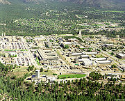 |
Los Alamos Los Alamos, New Mexico Los Alamos is a townsite and census-designated place in Los Alamos County, New Mexico, United States, built upon four mesas of the Pajarito Plateau and the adjoining White Rock Canyon. The population of the CDP was 12,019 at the 2010 Census. The townsite or "the hill" is one part of town while... |
Los Alamos Los Alamos County, New Mexico -2010:Whereas according to the 2010 U.S. Census Bureau:*87.8% White*0.6% Black*0.8% Native American*6.0% Asian*0.0% Native Hawaiian or Pacific Islander*2.6% Two or more races*2.2% Other races*14.7% Hispanic or Latino -2000:... |
United States Department of Energy (DOE) national laboratory; site of the Manhattan Project | ||
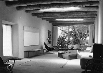
| Mabel Dodge Luhan House Mabel Dodge Luhan House Mabel Dodge Luhan House, also known as Big House and St. Teresa House is a house in Taos, New Mexico. It was a home of artist Mabel Dodge Luhan and was a haven for artists and writers.... |
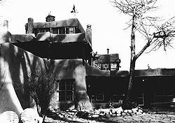 |
Taos Taos, New Mexico Taos is a town in Taos County in the north-central region of New Mexico, incorporated in 1934. As of the 2000 census, its population was 4,700. Other nearby communities include Ranchos de Taos, Cañon, Taos Canyon, Ranchitos, and El Prado. The town is close to Taos Pueblo, the Native American... |
Taos Taos County, New Mexico -2010:Whereas according to the 2010 U.S. Census Bureau:*68.7% White*0.4% Black*6.2% Native American*0.7% Asian*0.0% Native Hawaiian or Pacific Islander*3.9% Two or more races*20.1% Other races*55.8% Hispanic or Latino -2000:... |
Artists' haven, now a historic inn | ||
| Manuelito Complex Manuelito Complex Manuelito Complex, also known as Manuelito Canyon Historic District is a site near Manuelito, New Mexico.In 1964, the National Park Service identified:It was declared a National Historic Landmark in 1964.... |
Manuelito |
McKinley McKinley County, New Mexico -2010:Whereas according to the 2010 U.S. Census Bureau:*15.2% White*0.5% Black*75.5% Native American*0.8% Asian*0.0% Native Hawaiian or Pacific Islander*3.1% Two or more races*4.6% Other races*13.3% Hispanic or Latino -2000:... |
NRHP 66000894 | |||
| Mesilla Plaza Mesilla Plaza Mesilla Plaza, also known as the La Mesilla Historic District or a La Mesilla Historic District Multiple Resource Area, is an historic district in Mesilla, New Mexico.... |
 |
Mesilla Mesilla, New Mexico Mesilla is a town in Doña Ana County, New Mexico, United States. The population was 2,180 at the 2000 census... 32.271867°N 106.804479°W |
Dona Ana Doña Ana County, New Mexico -2010:Whereas according to the 2010 U.S. Census Bureau:*74.1% White*1.7% Black*1.5% Native American*1.1% Asian*0.1% Native Hawaiian or Pacific Islander*3.0% Two or more races*18.5% Other races*65.7% Hispanic or Latino -2000:... |
NRHP 66000475 | ||
| National Park Service Southwest Regional Office National Park Service Southwest Regional Office National Park Service Southwest Regional Office, also known as National Park Service Region III Headquarters Building, is an office building in Santa Fe, New Mexico. Designed by NPS architect Cecil Doty, it is a traditional adobe building, one-story except for a double-height entrance area, with... |
 |
Santa Fe Santa Fe, New Mexico Santa Fe is the capital of the U.S. state of New Mexico. It is the fourth-largest city in the state and is the seat of . Santa Fe had a population of 67,947 in the 2010 census... 35.665134°N 105.922622°W |
Santa Fe Santa Fe County, New Mexico -2010:Whereas according to the 2010 U.S. Census Bureau:*76.2% White*0.9% Black*3.1% Native American*1.2% Asian*0.1% Native Hawaiian or Pacific Islander*3.6% Two or more races*14.9% Other races*50.6% Hispanic or Latino -2000:... |
Masterpiece of Spanish/Pueblo revival architecture | ||
| Georgia O'Keeffe Home and Studio Georgia O'Keeffe Home and Studio The Georgia O'Keeffe Home and Studio is a site significant for its architecture and its association with artist Georgia O'Keeffe, who purchased the Abiquiu, New Mexico property from the Roman Catholic Archdiocese of Santa Fe in 1945, after attempting to buy it for some ten years... |
 |
Abiquiu Abiquiú, New Mexico Abiquiú, or Abiquiu is a small unincorporated town located in Rio Arriba County, in northern New Mexico in the southwestern United States, about 53 miles north of Santa Fe. In the 1730s, it was the third largest settlement in the New Mexico Territory... 36.206172°N 106.316872°W |
Rio Arriba Rio Arriba County, New Mexico -2010:Whereas according to the 2010 U.S. Census Bureau:*51.6% White*0.5% Black*16.0% Native American*0.4% Asian*0.0% Native Hawaiian or Pacific Islander*3.3% Two or more races*28.2% Other races*71.3% Hispanic or Latino -2000:... |
Home and studio of artist Georgia O'Keeffe Georgia O'Keeffe Georgia Totto O'Keeffe was an American artist.Born near Sun Prairie, Wisconsin, O'Keeffe first came to the attention of the New York art community in 1916, several decades before women had gained access to art training in America’s colleges and universities, and before any of its women artists... |
||
| Palace of the Governors Palace of the Governors The Palace of the Governors is an adobe structure located on Palace Avenue on the Plaza of Santa Fe, New Mexico between Palace Avenue and Washington Street. It is within the Santa Fe Historic District and it served as the seat of government for the State of New Mexico for centuries... |
 |
Santa Fe Santa Fe, New Mexico Santa Fe is the capital of the U.S. state of New Mexico. It is the fourth-largest city in the state and is the seat of . Santa Fe had a population of 67,947 in the 2010 census... 35.685936°N 105.937504°W |
Santa Fe Santa Fe County, New Mexico -2010:Whereas according to the 2010 U.S. Census Bureau:*76.2% White*0.9% Black*3.1% Native American*1.2% Asian*0.1% Native Hawaiian or Pacific Islander*3.6% Two or more races*14.9% Other races*50.6% Hispanic or Latino -2000:... |
Adobe structure; construction began in 1610; served as the seat of government in New Mexico for centuries; oldest continuously occupied public building in the United States | ||
| Pecos Pueblo Pecos National Historical Park Pecos National Historical Park is a National Historical Park in the U.S. state of New Mexico. It is located about east of Santa Fe, New Mexico. The site was originally designated Pecos National Monument on June 28, 1965. In 1990 new lands were added to the park and the official designation was... |
 |
Pecos Pecos, New Mexico Pecos is a village in San Miguel County, New Mexico, United States. The population was 1,441 at the 2000 census, growing much faster than in other parts of San Miguel County, partly because Pecos is within commuting distance of Santa Fe. The village is built along the Pecos River which flows from... |
San Miguel San Miguel County, New Mexico -2010:Whereas according to the 2010 U.S. Census Bureau:*66.6% White*1.4% Black*1.7% Native American*0.8% Asian*0.1% Native Hawaiian or Pacific Islander*3.9% Two or more races*25.5% Other races*76.8% Hispanic or Latino -2000:... |
NRHP 66000485, Pecos National Historical Park Pecos National Historical Park Pecos National Historical Park is a National Historical Park in the U.S. state of New Mexico. It is located about east of Santa Fe, New Mexico. The site was originally designated Pecos National Monument on June 28, 1965. In 1990 new lands were added to the park and the official designation was... |
||
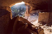
| Puye Ruins Puye Cliff Dwellings The Puye Cliff Dwellings are the ruins of an abandoned pueblo, located in Santa Clara Canyon on Santa Clara Pueblo land near Española, New Mexico. The site was declared a National Historic Landmark in 1966.-Ancient pueblo dwellings:... |
 |
Espanola Española, New Mexico Española also known as Espanola , is a city primarily in Rio Arriba County, New Mexico, in the United States. A portion of the central and eastern section of the city is in Santa Fe County. Española was founded in 1880 as a railroad village, incorporated as a city in 1925. The city is situated in... |
Rio Arriba Rio Arriba County, New Mexico -2010:Whereas according to the 2010 U.S. Census Bureau:*51.6% White*0.5% Black*16.0% Native American*0.4% Asian*0.0% Native Hawaiian or Pacific Islander*3.3% Two or more races*28.2% Other races*71.3% Hispanic or Latino -2000:... and Sandoval Sandoval County, New Mexico -Indian reservations:Sandoval County has 12 Indian reservations and two joint-use areas lying within its borders, the second most of any county in the United States -Indian reservations:Sandoval County has 12 Indian reservations and two joint-use areas lying within its borders, the second most of... |
NRHP 66000481 | ||
| Ernie Pyle House Ernie Pyle House/Library The Ernie Pyle House/Library, at 900 Girard Boulevard, SE in Albuquerque, New Mexico, is the former home of famed war correspondent Ernie Pyle. It is a branch of the Albuquerque/Bernalillo County Library System and contains Pyle memorabilia and a monument to Pyle, who was killed in the Pacific in... |
 |
Albuquerque Albuquerque, New Mexico Albuquerque is the largest city in the state of New Mexico, United States. It is the county seat of Bernalillo County and is situated in the central part of the state, straddling the Rio Grande. The city population was 545,852 as of the 2010 Census and ranks as the 32nd-largest city in the U.S. As... |
Bernalillo Bernalillo County, New Mexico -2010:Whereas according to the 2010 U.S. Census Bureau:*69.4% White*3.0% Black*4.8% Native American*2.3% Asian*0.1% Native Hawaiian or Pacific Islander*4.4% Two or more races*16.0% Other races*47.9% Hispanic or Latino -2000:... |
Former home of famed war correspondent Ernie Pyle | ||
| Quarai Quarai The Quarai were a Tiguex Puebloan band of American Indians that originated in present-day New Mexico. Because of Apache hostilities they fled to El Paso in around 1675; later they moved to Isleta del Sur on the Rio Grande.... |
 |
Manzano Manzano, New Mexico Manzano is a census-designated place in Torrance County, New Mexico, United States. The population was 54 at the 2000 census. The Quarai Ruins of Salinas Pueblo Missions National Monument are located near the town. The center of population of New Mexico is located in Manzano .Manzano is part of... |
Torrance Torrance County, New Mexico -2010:Whereas according to the 2010 U.S. Census Bureau:*76.1% White*1.3% Black*2.3% Native American*0.4% Asian*0.0% Native Hawaiian or Pacific Islander*4.3% Two or more races*15.6% Other races*39.1% Hispanic or Latino -2000:... |
Ruins in Salinas Pueblo Missions National Monument Salinas Pueblo Missions National Monument The Salinas Pueblo Missions National Monument is located in the U.S. state of New Mexico, near Mountainair. The main park visitor center is in Mountainair.-History:... |
||
| Rabbit Ears Rabbit Ears (Clayton, New Mexico) Rabbit Ears is a pair of mountain peaks that were landmarks over the Cimarron Cutoff of the Santa Fe Trail. The Clayton Complex includes that, another mountain peak, and three camps between them: McNees Crossing, Turkey Creek Camp, and Rabbit Ears Camp.It was declared a National Historic Landmark... |
image pending | Clayton Clayton, New Mexico Clayton is a town in Union County, New Mexico, United States. The population was 2,524 at the 2000 census. It is the county seat of Union County. Tourists heading from Texas to Colorado often pass through Clayton, which is located in the northeast corner of New Mexico.Clayton is named for a son of... |
Union Union County, New Mexico -2010:Whereas according to the 2010 U.S. Census Bureau:*81.7% White*1.8% Black*2.0% Native American*0.5% Asian*0.0% Native Hawaiian or Pacific Islander*2.3% Two or more races*11.7% Other races*39.7% Hispanic or Latino -2000:... |
Twin mountain peaks that were landmarks to wagon trains | ||
| Raton Pass Raton Pass Raton Pass is a mountain pass on the Santa Fe Trail along the Colorado-New Mexico border in the United States. Raton Pass is a federally designated National Historic Landmark... |
 |
Raton, NM Raton, New Mexico Raton is a city in Colfax County, New Mexico, United States. The population was 7,282 at the 2000 census. It is the county seat of Colfax County. The city is located just south of Raton Pass.-Name:... and Trinidad, CO Trinidad, Colorado The historic City of Trinidad is a Home Rule Municipality that is the county seat and the most populous city of Las Animas County, Colorado, United States... |
Colfax, NM Colfax County, New Mexico -2010:Whereas according to the 2010 U.S. Census Bureau:*83.8% White*0.5% Black*1.5% Native American*0.4% Asian*0.1% Native Hawaiian or Pacific Islander*3.6% Two or more races*10.1% Other races*47.2% Hispanic or Latino -2000:... and Las Animas, CO Las Animas County, Colorado Las Animas County has the largest area of the 64 counties of the State of Colorado of the United States. Las Animas County takes its name from the Mexican Spanish name of the Purgatoire River, originally called El Río de las Ánimas Perdidas en Purgatorio, which means "River of the Lost Souls in... |
Mountain pass on the Santa Fe Trail along the Colorado-New Mexico border. Also in Colorado. | ||
| San Estevan Del Rey Mission Church San Estevan Del Rey Mission Church San Estevan del Rey Mission Church is a church that was founded in 1629 in Acoma, New Mexico. It was named for Stephen I of Hungary.It was declared a National Historic Landmark in 1970.-External links:***, at Historic American Building Survey... |
.jpg) |
Acoma |
Valencia Valencia County, New Mexico -2010:Whereas according to the 2010 U.S. Census Bureau:*73.2% White*1.4% Black*3.8% Native American*0.5% Asian*0.1% Native Hawaiian or Pacific Islander*4.0% Two or more races*17.0% Other races*58.3% Hispanic or Latino -2000:... |
Church founded in 1629 | ||
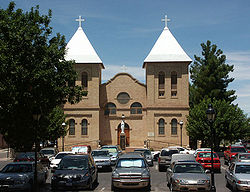
| San Francisco de Assisi Mission Church San Francisco de Assisi Mission Church San Francisco de Asis Mission Church is a church built between 1772 and 1816. It is located on the plaza in Ranchos de Taos, itself a historic district named Ranchos de Taos Plaza, about four miles southwest of the town of Taos, New Mexico.... |
.jpg) |
Ranchos de Taos Ranchos de Taos, New Mexico Ranchos de Taos is a census-designated place in Taos County, New Mexico, United States. The population was 2,390 at the 2000 census.-Geography:Ranchos de Taos is located at .... |
Taos Taos County, New Mexico -2010:Whereas according to the 2010 U.S. Census Bureau:*68.7% White*0.4% Black*6.2% Native American*0.7% Asian*0.0% Native Hawaiian or Pacific Islander*3.9% Two or more races*20.1% Other races*55.8% Hispanic or Latino -2000:... |
Mission church on Ranchos de Taos Plaza Ranchos de Taos Plaza Ranchos de Taos Plaza is a historic district in Ranchos de Taos, New Mexico, about four miles south of the town of Taos, New Mexico.It includes San Francisco de Assisi Mission Church, a U.S. National Historic Landmark.-External links:*... |
||
| San Gabriel De Yungue-ouinge San Gabriel de Yungue-Ouinge San Gabriel de Yungue-Ouinge was the site of the first Spanish capital in New Mexico.It was declared a National Historic Landmark in 1964.It was then stated:-External links:*, at Historic American Building Survey... |
.jpg) |
Espanola Española, New Mexico Española also known as Espanola , is a city primarily in Rio Arriba County, New Mexico, in the United States. A portion of the central and eastern section of the city is in Santa Fe County. Española was founded in 1880 as a railroad village, incorporated as a city in 1925. The city is situated in... |
Rio Arriba Rio Arriba County, New Mexico -2010:Whereas according to the 2010 U.S. Census Bureau:*51.6% White*0.5% Black*16.0% Native American*0.4% Asian*0.0% Native Hawaiian or Pacific Islander*3.3% Two or more races*28.2% Other races*71.3% Hispanic or Latino -2000:... |
First Spanish capitol of New Mexico | ||
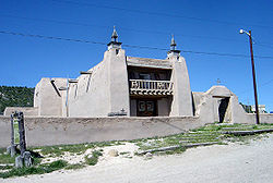
| San José de Gracia Church San José de Gracia Church The San Jose de Gracia Church, also known as Church of Santo Tomas Del Rio de Las Trampas, is a church built between 1760 and 1776 in Las Trampas, New Mexico. Originally named Santo Tomas del Rio de las Trampas, the church is of adobe construction with a mud-plaster exterior, which is renewed... |
|
Las Trampas Las Trampas, New Mexico Las Trampas or Trampas is a small unincorporated town in Taos County, New Mexico, United States. Located on the scenic High Road to Taos , it is approximately halfway between Santa Fe to the south and Taos to the north.Founded in 1751 by twelve Spanish families from Santa Fe, it is known for the... |
Taos Taos County, New Mexico -2010:Whereas according to the 2010 U.S. Census Bureau:*68.7% White*0.4% Black*6.2% Native American*0.7% Asian*0.0% Native Hawaiian or Pacific Islander*3.9% Two or more races*20.1% Other races*55.8% Hispanic or Latino -2000:... |
Built between 1760 and 1776; model of the adobe architecture; once used by Los Hermanos Penitentes | ||
| San Lazaro | Santa Fe Santa Fe, New Mexico Santa Fe is the capital of the U.S. state of New Mexico. It is the fourth-largest city in the state and is the seat of . Santa Fe had a population of 67,947 in the 2010 census... |
Santa Fe Santa Fe County, New Mexico -2010:Whereas according to the 2010 U.S. Census Bureau:*76.2% White*0.9% Black*3.1% Native American*1.2% Asian*0.1% Native Hawaiian or Pacific Islander*3.6% Two or more races*14.9% Other races*50.6% Hispanic or Latino -2000:... |
NRHP 66000490 | |||
| Sandia Cave Sandia Cave Sandia Cave is an archaeological site near Bernalillo, New Mexico that is open to the public. It is rather difficult to reach, as it is located high up on the steep wall of Las Huertas Canyon on the north end of the Sandia Mountains.... |
image pending | Bernalillo Bernalillo, New Mexico Bernalillo is a town in Sandoval County, New Mexico, in the United States. As of the 2000 census, the town population was 6,611. It is the county seat of Sandoval County.Bernalillo is part of the Albuquerque Metropolitan Statistical Area.-Geography:... |
Sandoval Sandoval County, New Mexico -Indian reservations:Sandoval County has 12 Indian reservations and two joint-use areas lying within its borders, the second most of any county in the United States -Indian reservations:Sandoval County has 12 Indian reservations and two joint-use areas lying within its borders, the second most of... |
NRHP 66000487 | ||
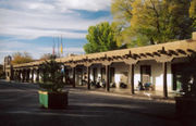
| Santa Fe Plaza Santa Fe Plaza Mirroring the traditional Spanish-American colonial cities, the Santa Fe Plaza is a National Historic Landmark in downtown Santa Fe, New Mexico. The plaza, or "city-square", was originally, and is still to this day, the center gathering place in town, or as many know it "the heart of Santa Fe." The... |
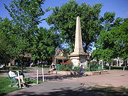 |
Santa Fe Santa Fe, New Mexico Santa Fe is the capital of the U.S. state of New Mexico. It is the fourth-largest city in the state and is the seat of . Santa Fe had a population of 67,947 in the 2010 census... 35.685396°N 105.937498°W |
Santa Fe Santa Fe County, New Mexico -2010:Whereas according to the 2010 U.S. Census Bureau:*76.2% White*0.9% Black*3.1% Native American*1.2% Asian*0.1% Native Hawaiian or Pacific Islander*3.6% Two or more races*14.9% Other races*50.6% Hispanic or Latino -2000:... |
Central park lined with grass, trees, and benches; Indian War Memorial monument; performing arts stage | ||
| Seton Village Seton Village Seton Village is a historic district or site in Santa Fe, New Mexico. It is the location of Ernest Thompson Seton's home, Seton Castle and were he ran training camps for youth leaders and had a small press.... |
Santa Fe Santa Fe, New Mexico Santa Fe is the capital of the U.S. state of New Mexico. It is the fourth-largest city in the state and is the seat of . Santa Fe had a population of 67,947 in the 2010 census... |
Santa Fe Santa Fe County, New Mexico -2010:Whereas according to the 2010 U.S. Census Bureau:*76.2% White*0.9% Black*3.1% Native American*1.2% Asian*0.1% Native Hawaiian or Pacific Islander*3.6% Two or more races*14.9% Other races*50.6% Hispanic or Latino -2000:... |
NRHP 66000492 | |||
| Taos Pueblo Taos Pueblo Taos Pueblo is an ancient pueblo belonging to a Taos speaking Native American tribe of Pueblo people. It is approximately 1000 years old and lies about north of the modern city of Taos, New Mexico, USA... |
Taos Taos, New Mexico Taos is a town in Taos County in the north-central region of New Mexico, incorporated in 1934. As of the 2000 census, its population was 4,700. Other nearby communities include Ranchos de Taos, Cañon, Taos Canyon, Ranchitos, and El Prado. The town is close to Taos Pueblo, the Native American... |
Taos Taos County, New Mexico -2010:Whereas according to the 2010 U.S. Census Bureau:*68.7% White*0.4% Black*6.2% Native American*0.7% Asian*0.0% Native Hawaiian or Pacific Islander*3.9% Two or more races*20.1% Other races*55.8% Hispanic or Latino -2000:... |
Ancient pueblo belonging to a Northern Tiwa speaking Native American tribe of Pueblo people; approximately 1000 years old; multi-storied residential complex of reddish-brown adobe divided into two parts by the Rio Pueblo de Taos Rio Pueblo de Taos The Rio Pueblo de Taos, also known as Rio Pueblo, is tributary of the Rio Grande in the U.S. state of New Mexico. From its source in the Sangre de Cristo Mountains it flows about , generally south and west, to join the Rio Grande in the Rio Grande Gorge... |
|||
| Trinity Site | Bingham |
Socorro Socorro County, New Mexico -2010:Whereas according to the 2010 U.S. Census Bureau:*75.1% White*1.1% Black*11.7% Native American*1.2% Asian*0.0% Native Hawaiian or Pacific Islander*2.8% Two or more races*8.1% Other races*48.5% Hispanic or Latino -2000:... |
Site of the first test of technology for a nuclear weapon | |||
| Village of Columbus and Camp Furlong Village of Columbus and Camp Furlong Village of Columbus and Camp Furlong is a historic district that includes portions of what is now the town of Columbus, New Mexico, Pancho Villa State Park, and an airfield, all in Columbus, New Mexico... |
 |
Columbus Columbus, New Mexico Columbus is a village in Luna County, New Mexico, United States. The population was 1,765 at the 2000 census. The town is named after 15th century explorer Christopher Columbus.-History:... |
Luna Luna County, New Mexico -2010:Whereas according to the 2010 U.S. Census Bureau:*77.7% White*1.1% Black*1.3% Native American*0.5% Asian*0.0% Native Hawaiian or Pacific Islander*2.6% Two or more races*16.8% Other races*61.5% Hispanic or Latino -2000:... |
Site of 1914 raid by Pancho Villa Pancho Villa José Doroteo Arango Arámbula – better known by his pseudonym Francisco Villa or its hypocorism Pancho Villa – was one of the most prominent Mexican Revolutionary generals.... that had wide impacts |
||
| Wagon Mound Wagon Mound National Historic Landmark Wagon Mound is a butte that was a landmark for pioneers, which has been designated a National Historic Landmark. It is located above Wagon Mound, New Mexico, a village named after the butte.... |
 |
Wagon Mound Wagon Mound, New Mexico Wagon Mound is a village in Mora County, New Mexico, United States. It is named after and located at the foot of a butte called Wagon Mound, which was a landmark for covered wagon trains and traders going up and down the Santa Fe Trail and is now Wagon Mound National Historic Landmark. The shape... |
Mora Mora County, New Mexico -2010:Whereas according to the 2010 U.S. Census Bureau:*70.9% White*0.7% Black*1.3% Native American*0.3% Asian*0.0% Native Hawaiian or Pacific Islander*3.3% Two or more races*23.5% Other races*81.0% Hispanic or Latino -2000:... |
Landmark on the Santa Fe Trail Santa Fe Trail The Santa Fe Trail was a 19th-century transportation route through central North America that connected Missouri with Santa Fe, New Mexico. Pioneered in 1822 by William Becknell, it served as a vital commercial and military highway until the introduction of the railroad to Santa Fe in 1880... |
||
| Watrous Watrous (La Junta) Watrous, also named La Junta, is a historic district in New Mexico.The National Park Service's Statement of Significance for the site was:Trail ruts remain, and the district includes 21 structures:... |
.jpg) |
Watrous |
Mora Mora County, New Mexico -2010:Whereas according to the 2010 U.S. Census Bureau:*70.9% White*0.7% Black*1.3% Native American*0.3% Asian*0.0% Native Hawaiian or Pacific Islander*3.3% Two or more races*23.5% Other races*81.0% Hispanic or Latino -2000:... |
Mountain and Cimarron Cutoff routes of Santa Fe Trail Santa Fe Trail The Santa Fe Trail was a 19th-century transportation route through central North America that connected Missouri with Santa Fe, New Mexico. Pioneered in 1822 by William Becknell, it served as a vital commercial and military highway until the introduction of the railroad to Santa Fe in 1880... joined here |
||
| White Sands V-2 Launching Site White Sands V-2 Launching Site White Sands V-2 Launching Site, also known as Launch Complex 33 or White Sands Blockhouse and Ga____..., is located in the White Sands Missile Range.According to the National Park Service:It was declared a National Historic Landmark in 1985.... |
White Sands Missile Range White Sands Missile Range White Sands Missile Range is a rocket range of almost in parts of five counties in southern New Mexico. The largest military installation in the United States, WSMR includes the and the WSMR Otera Mesa bombing range... 32.399378°N 106.377814°W |
Dona Ana Doña Ana County, New Mexico -2010:Whereas according to the 2010 U.S. Census Bureau:*74.1% White*1.7% Black*1.5% Native American*1.1% Asian*0.1% Native Hawaiian or Pacific Islander*3.0% Two or more races*18.5% Other races*65.7% Hispanic or Latino -2000:... |
||||
| Zuni-Cibola Complex Zuni-Cibola Complex Zuni-Cibola Complex, which comprises Hawikuh, Yellow House, Kechipbowa, and Great Kivas, is a set of sites near Zuni, New Mexico.It was declared a National Historic Landmark District in 1974.Hawikuh Ruins is itself a National Historic Landmark.... |
Zuni Pueblo Zuni Pueblo, New Mexico Zuni Pueblo is a census-designated place in McKinley County, New Mexico, United States. The population was 6,367 at the 2000 census... |
Cibola Cibola County, New Mexico -2010:Whereas according to the 2010 U.S. Census Bureau:*41.8% White*1.0% Black*41.0% Native American*0.5% Asian*0.1% Native Hawaiian or Pacific Islander*3.1% Two or more races*12.5% Other races*36.5% Hispanic or Latino -2000:... , McKinley McKinley County, New Mexico -2010:Whereas according to the 2010 U.S. Census Bureau:*15.2% White*0.5% Black*75.5% Native American*0.8% Asian*0.0% Native Hawaiian or Pacific Islander*3.1% Two or more races*4.6% Other races*13.3% Hispanic or Latino -2000:... , and Valencia Valencia County, New Mexico -2010:Whereas according to the 2010 U.S. Census Bureau:*73.2% White*1.4% Black*3.8% Native American*0.5% Asian*0.1% Native Hawaiian or Pacific Islander*4.0% Two or more races*17.0% Other races*58.3% Hispanic or Latino -2000:... |
NRHP 74002267 | |||
Historic areas of the NPS in New Mexico
National Historical Parks, some National Monuments, and certain other areas listed in the National Park system are historic landmarks of national importance that are highly protected already, often before the inauguration of the NHL program in 1960, and are then often not also named NHLs per se. There are nine of these in New Mexico. The National Park Service lists these fourteen together with the NHLs in the state,They are:
| Landmark name |
Image | Date established | Location | County | Description | |
|---|---|---|---|---|---|---|
| Aztec Ruins National Monument Aztec Ruins National Monument The Aztec Ruins National Monument preserves ancestral Pueblo structures in north-western New Mexico, United States, located close to the town of Aztec and northeast of Farmington, near the Animas River... |
 |
Aztec Aztec, New Mexico Aztec is a city in San Juan County, New Mexico, United States. It is part of the Farmington, New Mexico Metropolitan Statistical Area. The population was 6,378 at the 2000 census. It is the county seat of San Juan County... |
San Juan San Juan County, New Mexico -2010:Whereas according to the 2010 U.S. Census Bureau:*51.6% White*0.6% Black*36.6% Native American*0.4% Asian*0.1% Native Hawaiian or Pacific Islander*3.5% Two or more races*7.2% Other races*19.1% Hispanic or Latino -2000:... |
Preserves ancestral Pueblo structures in north-western New Mexico | ||
| Bandelier National Monument Bandelier National Monument Bandelier National Monument is a National Monument preserving the homes of the Ancestral Pueblo People. It is named after Swiss anthropologist Adolph Bandelier, who researched the cultures of the area. Bandelier was designated a National Monument on February 11, 1916, and most of its backcountry... |
 |
Santa Fe Santa Fe, New Mexico Santa Fe is the capital of the U.S. state of New Mexico. It is the fourth-largest city in the state and is the seat of . Santa Fe had a population of 67,947 in the 2010 census... |
Sandoval Sandoval County, New Mexico -Indian reservations:Sandoval County has 12 Indian reservations and two joint-use areas lying within its borders, the second most of any county in the United States -Indian reservations:Sandoval County has 12 Indian reservations and two joint-use areas lying within its borders, the second most of... and Los Alamos Los Alamos County, New Mexico -2010:Whereas according to the 2010 U.S. Census Bureau:*87.8% White*0.6% Black*0.8% Native American*6.0% Asian*0.0% Native Hawaiian or Pacific Islander*2.6% Two or more races*2.2% Other races*14.7% Hispanic or Latino -2000:... |
Includes Frijoles Canyon; contains (restored) ruins of dwellings, kivas, rock paintings and petroglyphs | ||
| Chaco Culture National Historical Park Chaco Culture National Historical Park Chaco Culture National Historical Park is a United States National Historical Park hosting the densest and most exceptional concentration of pueblos in the American Southwest. The park is located in northwestern New Mexico, between Albuquerque and Farmington, in a remote canyon cut by the Chaco Wash... |
Farmington Farmington, New Mexico Farmington is a city in San Juan County in the U.S. state of New Mexico. As of the 2010 U.S. Census the city had a total population of 45,877 people. Farmington makes up one of the four Metropolitan Statistical Areas in New Mexico. The U.S... |
San Juan San Juan County, New Mexico -2010:Whereas according to the 2010 U.S. Census Bureau:*51.6% White*0.6% Black*36.6% Native American*0.4% Asian*0.1% Native Hawaiian or Pacific Islander*3.5% Two or more races*7.2% Other races*19.1% Hispanic or Latino -2000:... and McKinley McKinley County, New Mexico -2010:Whereas according to the 2010 U.S. Census Bureau:*15.2% White*0.5% Black*75.5% Native American*0.8% Asian*0.0% Native Hawaiian or Pacific Islander*3.1% Two or more races*4.6% Other races*13.3% Hispanic or Latino -2000:... |
Densest and most exceptional concentration of pueblos in the American Southwest | |||
| El Morro National Monument El Morro National Monument El Morro National Monument is located on an ancient east-west trail in western New Mexico. The main feature of this National Monument is a great sandstone promontory with a pool of water at its base. As a shaded oasis in the western U.S. desert, this site has seen many centuries of travelers... |
Ramah Ramah, New Mexico Ramah is a census-designated place in McKinley County, New Mexico, United States. The population was 407 at the 2000 census.-Geography:Ramah is located at... |
Cibola Cibola County, New Mexico -2010:Whereas according to the 2010 U.S. Census Bureau:*41.8% White*1.0% Black*41.0% Native American*0.5% Asian*0.1% Native Hawaiian or Pacific Islander*3.1% Two or more races*12.5% Other races*36.5% Hispanic or Latino -2000:... |
Sandstone promontory with a pool of water at its base; shaded oasis in the western U.S. deser; Zuni Indians call it "A'ts'ina" (Place of writings on the rock); Anglo-Americans called it "Inscription Rock"; travelers left signatures, names, dates, and stories of their treks | |||
| Fort Union National Monument Fort Union National Monument Fort Union National Monument is a unit of the National Park Service located north of Watrous, Mora County, New Mexico, USA. The national monument was founded on June 28, 1954.... |
 |
Las Vegas, NM Las Vegas, New Mexico Las Vegas is a city in San Miguel County, New Mexico, United States. Once two separate municipalities both named Las Vegas, west Las Vegas and east Las Vegas , divided by the Gallinas River, retain distinct characters and separate, rival school districts. The population was 14,565 at the 2000... |
Mora Mora County, New Mexico -2010:Whereas according to the 2010 U.S. Census Bureau:*70.9% White*0.7% Black*1.3% Native American*0.3% Asian*0.0% Native Hawaiian or Pacific Islander*3.3% Two or more races*23.5% Other races*81.0% Hispanic or Latino -2000:... |
Preserves the second of three forts constructed on the site beginning in 1851; also ruins of the third; visible network of ruts from the old Santa Fe Trail | ||
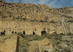
| Gila Cliff Dwellings National Monument Gila Cliff Dwellings National Monument Gila Cliff Dwellings National Monument is a U.S. National Monument in the Gila Wilderness of southwestern New Mexico. The national monument was established by executive proclamation on November 16, 1907, by President Theodore Roosevelt. It is located in the extreme southern part of Catron County... |
 |
Silver City Silver City, New Mexico Silver City is a town in Grant County, New Mexico, in the United States. As of the 2000 census, the town population was 10,545. It is the county seat of Grant County. The city is the home of Western New Mexico University.-History:... |
Catron Grant County, New Mexico -2010:Whereas according to the 2010 U.S. Census Bureau:*84.9% White*0.9% Black*1.4% Native American*0.4% Asian*0.1% Native Hawaiian or Pacific Islander*2.8% Two or more races*9.8% Other races*48.3% Hispanic or Latino -2000:... |
Cliff dwellings from the 1280s through the early 1300s | ||
| Pecos National Historical Park Pecos National Historical Park Pecos National Historical Park is a National Historical Park in the U.S. state of New Mexico. It is located about east of Santa Fe, New Mexico. The site was originally designated Pecos National Monument on June 28, 1965. In 1990 new lands were added to the park and the official designation was... |
|
Santa Fe Santa Fe, New Mexico Santa Fe is the capital of the U.S. state of New Mexico. It is the fourth-largest city in the state and is the seat of . Santa Fe had a population of 67,947 in the 2010 census... |
Santa Fe Santa Fe County, New Mexico -2010:Whereas according to the 2010 U.S. Census Bureau:*76.2% White*0.9% Black*3.1% Native American*1.2% Asian*0.1% Native Hawaiian or Pacific Islander*3.6% Two or more races*14.9% Other races*50.6% Hispanic or Latino -2000:... and San Miguel San Miguel County, New Mexico -2010:Whereas according to the 2010 U.S. Census Bureau:*66.6% White*1.4% Black*1.7% Native American*0.8% Asian*0.1% Native Hawaiian or Pacific Islander*3.9% Two or more races*25.5% Other races*76.8% Hispanic or Latino -2000:... |
Includes parts of Glorieta Pass Battlefield Glorieta Pass Battlefield Glorieta Pass Battlefield, also known as Glorieta Pass, was the site of a decisive American Civil War battle that ended Confederate ambitions to cut off the West from the Union... , an NHL, as well as a mission and other areas. |
||
| Petroglyph National Monument Petroglyph National Monument Petroglyph National Monument stretches along Albuquerque, New Mexico's West Mesa, a volcanic basalt escarpment that dominates the city’s western horizon. Authorized June 27, 1990, the 7,236 acre monument is cooperatively managed by the National Park Service and the City of Albuquerque... |
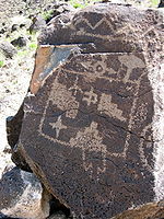 |
Albuquerque Albuquerque, New Mexico Albuquerque is the largest city in the state of New Mexico, United States. It is the county seat of Bernalillo County and is situated in the central part of the state, straddling the Rio Grande. The city population was 545,852 as of the 2010 Census and ranks as the 32nd-largest city in the U.S. As... |
Bernalillo Bernalillo County, New Mexico -2010:Whereas according to the 2010 U.S. Census Bureau:*69.4% White*3.0% Black*4.8% Native American*2.3% Asian*0.1% Native Hawaiian or Pacific Islander*4.4% Two or more races*16.0% Other races*47.9% Hispanic or Latino -2000:... |
Variety of cultural and natural resources including five volcanic cones, hundreds of archeological sites and an estimated 25,000 images carved by native peoples and early Spanish settlers | ||
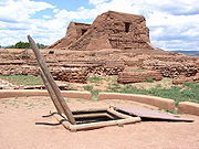
| Salinas Pueblo Missions National Monument Salinas Pueblo Missions National Monument The Salinas Pueblo Missions National Monument is located in the U.S. state of New Mexico, near Mountainair. The main park visitor center is in Mountainair.-History:... |
Albuquerque Albuquerque, New Mexico Albuquerque is the largest city in the state of New Mexico, United States. It is the county seat of Bernalillo County and is situated in the central part of the state, straddling the Rio Grande. The city population was 545,852 as of the 2010 Census and ranks as the 32nd-largest city in the U.S. As... |
Torrance Torrance County, New Mexico -2010:Whereas according to the 2010 U.S. Census Bureau:*76.1% White*1.3% Black*2.3% Native American*0.4% Asian*0.0% Native Hawaiian or Pacific Islander*4.3% Two or more races*15.6% Other races*39.1% Hispanic or Latino -2000:... and Socorro Socorro County, New Mexico -2010:Whereas according to the 2010 U.S. Census Bureau:*75.1% White*1.1% Black*11.7% Native American*1.2% Asian*0.0% Native Hawaiian or Pacific Islander*2.8% Two or more races*8.1% Other races*48.5% Hispanic or Latino -2000:... |
Reminders of this earliest contact between Pueblo Indians and Spanish Colonials: the ruins of four mission churches and the partially excavated pueblo of Las Humanas | |||
See also
External links
- National Register Information System, National Park Service.