Mesilla, New Mexico
Encyclopedia
- Mesilla is also a spider genus (Anyphaenidae).
Mesilla (also known as La Mesilla and Old Mesilla) is a town in Doña Ana County
Doña Ana County, New Mexico
-2010:Whereas according to the 2010 U.S. Census Bureau:*74.1% White*1.7% Black*1.5% Native American*1.1% Asian*0.1% Native Hawaiian or Pacific Islander*3.0% Two or more races*18.5% Other races*65.7% Hispanic or Latino -2000:...
, New Mexico
New Mexico
New Mexico is a state located in the southwest and western regions of the United States. New Mexico is also usually considered one of the Mountain States. With a population density of 16 per square mile, New Mexico is the sixth-most sparsely inhabited U.S...
, United States
United States
The United States of America is a federal constitutional republic comprising fifty states and a federal district...
. The population was 2,180 at the 2000 census. It is part of the Las Cruces
Las Cruces, New Mexico
Las Cruces, also known as "The City of the Crosses", is the county seat of Doña Ana County, New Mexico, United States. The population was 97,618 in 2010 according to the 2010 Census, making it the second largest city in the state....
Metropolitan Statistical Area.
During the American Civil War
American Civil War
The American Civil War was a civil war fought in the United States of America. In response to the election of Abraham Lincoln as President of the United States, 11 southern slave states declared their secession from the United States and formed the Confederate States of America ; the other 25...
, Mesilla briefly served as capital of the Confederate Territory of Arizona.
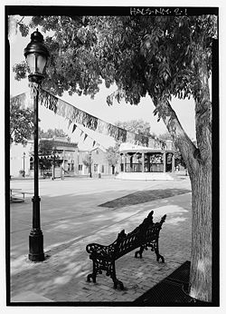
Mesilla Plaza
Mesilla Plaza
Mesilla Plaza, also known as the La Mesilla Historic District or a La Mesilla Historic District Multiple Resource Area, is an historic district in Mesilla, New Mexico....
is a National Historic Landmark
National Historic Landmark
A National Historic Landmark is a building, site, structure, object, or district, that is officially recognized by the United States government for its historical significance...
.
History
The village of Mesilla was incorporated in 1848, after the Treaty of Guadalupe HidalgoTreaty of Guadalupe Hidalgo
The Treaty of Guadalupe Hidalgo is the peace treaty, largely dictated by the United States to the interim government of a militarily occupied Mexico City, that ended the Mexican-American War on February 2, 1848...
moved the U.S.-Mexico border south of the village of Doña Ana
Doña Ana, New Mexico
Doña Ana is a census-designated place in Doña Ana County, New Mexico, in the United States. The population was 1,379 at the 2000 census. It is part of the Las Cruces Metropolitan Statistical Area.-Geography:...
, placing it in the United States. A small group of citizens, unhappy at being part of the United States, decided to move south of the border. They settled in Mesilla at this time.
By 1850, Mesilla was an established colony. By this time, its people were under constant threat of attack from the Apache
Apache
Apache is the collective term for several culturally related groups of Native Americans in the United States originally from the Southwest United States. These indigenous peoples of North America speak a Southern Athabaskan language, which is related linguistically to the languages of Athabaskan...
. By 1851, the attacks caused the United States to take action to protect its people just to the north of the border, in the Mesilla Valley
Mesilla Valley
The Mesilla Valley is a geographic feature of Southern New Mexico and far West Texas. It was formed by repeated heavy spring floods of the Rio Grande.The fertile Mesilla Valley extends from about Hatch, New Mexico to the west side of El Paso, Texas...
. They did this by creating Fort Fillmore
Fort Fillmore
Fort Fillmore was a fortification established by Col Edwin Vose Sumner in September of 1851 near Mesilla in what is now New Mexico, primarily to protect settlers and traders traveling to California. Travelers in the Westward Migration were under constant threat from Indian attack, and a network of...
. As a result of the fort, the United States declared the Mesilla Valley region part of the United States. Mexico also claimed this strip of land, causing it to become known as "No Mans Land." This boundary dispute, which was officially caused by a map error, was resolved in 1853, with the Gadsden Purchase
Gadsden Purchase
The Gadsden Purchase is a region of present-day southern Arizona and southwestern New Mexico that was purchased by the United States in a treaty signed by James Gadsden, the American ambassador to Mexico at the time, on December 30, 1853. It was then ratified, with changes, by the U.S...
. Mesilla became a part of the United States, as well as the southern part of New Mexico and Arizona
Arizona
Arizona ; is a state located in the southwestern region of the United States. It is also part of the western United States and the mountain west. The capital and largest city is Phoenix...
.
Two battles were fought at or in the town during the Civil War
American Civil War
The American Civil War was a civil war fought in the United States of America. In response to the election of Abraham Lincoln as President of the United States, 11 southern slave states declared their secession from the United States and formed the Confederate States of America ; the other 25...
. Mesilla served as the capital of the Confederate Territory of Arizona in 1861-1862 and was known as the "hub", or main city for the entire region. Recaptured by the Volunteers of the California Column
California Column
The California Column, a force of Union volunteers, marched from April to August 1862 over 900 miles from California, across the southern New Mexico Territory to the Rio Grande and then into western Texas during the American Civil War. At the time, this was the longest trek through desert terrain...
, it then became the headquarters of the Military District of Arizona
District of Arizona
District of Arizona was a subordinate district of the Department of New Mexico territory created on August 30, 1862 and transferred to the Department of the Pacific in March 1865.-District of Arizona Commanders:...
until 1864.
During the "Wild West" era, Mesilla was known for its cantina
Cantina
Cantina is a word that can refer to various places and establishments. It is similar in etymology to "canteen", and is derived from the Italian word for a cellar, winery, or vault.Cantinas are found in many towns of Italy...
s and festivals. The area attracted such figures as Billy the Kid
Billy the Kid
William H. Bonney William H. Bonney William H. Bonney (born William Henry McCarty, Jr. est. November 23, 1859 – c. July 14, 1881, better known as Billy the Kid but also known as Henry Antrim, was a 19th-century American gunman who participated in the Lincoln County War and became a frontier...
, Pat Garrett
Pat Garrett
Patrick Floyd "Pat" Garrett was an American Old West lawman, bartender, and customs agent who was best known for killing Billy the Kid...
and Pancho Villa
Pancho Villa
José Doroteo Arango Arámbula – better known by his pseudonym Francisco Villa or its hypocorism Pancho Villa – was one of the most prominent Mexican Revolutionary generals....
. The village was also the crossroads of two major stagecoach lines, Butterfield Stagecoach
Butterfield Overland Mail
The Butterfield Overland Mail Trail was a stagecoach route in the United States, operating from 1857 to 1861. It was a conduit for the U.S. mail from two eastern termini, Memphis, Tennessee and St. Louis, Missouri, meeting Fort Smith, Arkansas, and continuing through Indian Territory, New Mexico,...
and the Santa Fe Trail
Santa Fe Trail
The Santa Fe Trail was a 19th-century transportation route through central North America that connected Missouri with Santa Fe, New Mexico. Pioneered in 1822 by William Becknell, it served as a vital commercial and military highway until the introduction of the railroad to Santa Fe in 1880...
. The village of Mesilla was the most important city of the region until 1881.
In 1881, the Santa Fe Railway was ready to build through the Gadsden Purchase region of the country. Mesilla was naturally seen as the city the railroad would run through. However, the people of Mesilla asked for too much money for the land rights, and a land owner in nearby Las Cruces, New Mexico
Las Cruces, New Mexico
Las Cruces, also known as "The City of the Crosses", is the county seat of Doña Ana County, New Mexico, United States. The population was 97,618 in 2010 according to the 2010 Census, making it the second largest city in the state....
, a much smaller village than Mesilla, stepped in and offered free land. The city of Mesilla has not grown much since, and Las Cruces has grown to a population of an estimated 95,000 people (2010) and is currently the second largest city in New Mexico.
La Mesilla Historic District, which includes Mesilla Plaza
Mesilla Plaza
Mesilla Plaza, also known as the La Mesilla Historic District or a La Mesilla Historic District Multiple Resource Area, is an historic district in Mesilla, New Mexico....
, was declared a National Historic Landmark
National Historic Landmark
A National Historic Landmark is a building, site, structure, object, or district, that is officially recognized by the United States government for its historical significance...
in 1961.
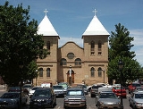
In 2008, the Roman Catholic parish church of San Albino
Basilica of San Albino
Basilica of San Albino, formerly known as San Albino Church of Mesilla, is part of the Roman Catholic Diocese of Las Cruces and located in Mesilla, New Mexico. It has the distinction of being established in Mexico, and is now located in the United States...
was raised to the status of minor basilica by the Holy See
Holy See
The Holy See is the episcopal jurisdiction of the Catholic Church in Rome, in which its Bishop is commonly known as the Pope. It is the preeminent episcopal see of the Catholic Church, forming the central government of the Church. As such, diplomatically, and in other spheres the Holy See acts and...
.
Geography
Mesilla is located at 32°16′22"N 106°48′3"W (32.272776, -106.800965).According to the United States Census Bureau
United States Census Bureau
The United States Census Bureau is the government agency that is responsible for the United States Census. It also gathers other national demographic and economic data...
, the town has a total area of 5.4 square miles (14 km²), all of it land.
Demographics
Census
A census is the procedure of systematically acquiring and recording information about the members of a given population. It is a regularly occurring and official count of a particular population. The term is used mostly in connection with national population and housing censuses; other common...
of 2000, there were 2,180 people, 892 households, and 595 families residing in the town. The population density
Population density
Population density is a measurement of population per unit area or unit volume. It is frequently applied to living organisms, and particularly to humans...
was 407.0 people per square mile (157.0/km²). There were 981 housing units at an average density of 183.1 per square mile (70.7/km²). The racial makeup of the town was 73.99% White, 0.23% African American, 1.01% Native American, 0.23% Asian, 0.05% Pacific Islander, 20.69% from other races
Race (United States Census)
Race and ethnicity in the United States Census, as defined by the Federal Office of Management and Budget and the United States Census Bureau, are self-identification data items in which residents choose the race or races with which they most closely identify, and indicate whether or not they are...
, and 3.81% from two or more races. Hispanic or Latino of any race were 52.20% of the population.
There were 892 households out of which 25.6% had children under the age of 18 living with them, 53.5% were married couples
Marriage
Marriage is a social union or legal contract between people that creates kinship. It is an institution in which interpersonal relationships, usually intimate and sexual, are acknowledged in a variety of ways, depending on the culture or subculture in which it is found...
living together, 9.3% had a female householder with no husband present, and 33.2% were non-families. 27.8% of all households were made up of individuals and 8.9% had someone living alone who was 65 years of age or older. The average household size was 2.44 and the average family size was 2.99.
In the town the population was spread out with 22.2% under the age of 18, 7.9% from 18 to 24, 23.4% from 25 to 44, 29.4% from 45 to 64, and 17.2% who were 65 years of age or older. The median age was 43 years. For every 100 females there were 90.9 males. For every 100 females age 18 and over, there were 90.7 males.
The median income for a household in the town was $42,275, and the median income for a family was $51,181. Males had a median income of $30,500 versus $25,000 for females. The per capita income
Per capita income
Per capita income or income per person is a measure of mean income within an economic aggregate, such as a country or city. It is calculated by taking a measure of all sources of income in the aggregate and dividing it by the total population...
for the town was $25,922. About 6.3% of families and 9.4% of the population were below the poverty line, including 7.4% of those under age 18 and 5.8% of those age 65 or over.