
List of National Historic Landmarks in Nebraska
Encyclopedia
The List of National Historic Landmarks in Nebraska contains the landmarks designated by the U.S. Federal Government for the U.S. state
of Nebraska
.
There are 20 National Historic Landmark
s (NHLs) in Nebraska.
U.S. state
A U.S. state is any one of the 50 federated states of the United States of America that share sovereignty with the federal government. Because of this shared sovereignty, an American is a citizen both of the federal entity and of his or her state of domicile. Four states use the official title of...
of Nebraska
Nebraska
Nebraska is a state on the Great Plains of the Midwestern United States. The state's capital is Lincoln and its largest city is Omaha, on the Missouri River....
.
There are 20 National Historic Landmark
National Historic Landmark
A National Historic Landmark is a building, site, structure, object, or district, that is officially recognized by the United States government for its historical significance...
s (NHLs) in Nebraska.
Current NHLs in Nebraska
The twenty NHLs in Nebraska are distributed across 17 of Nebraska's 93 counties.| Landmark name | Image | Date declared | Locality |
County | Description | |
|---|---|---|---|---|---|---|
| Ash Hollow Cave Ash Hollow State Historical Park Ash Hollow State Historical Park is located near Lewellen, Nebraska. The park comprises two attractions, located . from each other: Ash Hollow Cave and Windlass Hill.-Ash Hollow Cave:... |
 |
Lewellen Lewellen, Nebraska Lewellen is a village in Garden County, Nebraska, United States. The population was 282 at the 2000 census.-Geography:Lewellen is located at .According to the United States Census Bureau, the village has a total area of , all land.... |
Garden Garden County, Nebraska -History:Garden County was formed in 1909 by popular vote. Voters in the general election of November 2, 1909, approved making the northern part of Deuel County into its own county... |
Included in Ash Hollow Historic District | ||
| William Jennings Bryan House William Jennings Bryan House The William Jennings Bryan House, also known as Fairview, is a historic house built in 1902 in Lincoln, Nebraska, United States. It is noteworthy as the home of William Jennings Bryan , and was declared a National Historic Landmark in 1963.... |
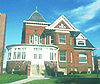 |
Lincoln Lincoln, Nebraska The City of Lincoln is the capital and the second-most populous city of the US state of Nebraska. Lincoln is also the county seat of Lancaster County and the home of the University of Nebraska. Lincoln's 2010 Census population was 258,379.... |
Lancaster Lancaster County, Nebraska -Demographics:As of the census of 2000, there were 250,291 people, 99,187 households, and 60,702 families residing in the county. The population density was 298 people per square mile . There were 104,217 housing units at an average density of 124 per square mile... |
The home of William Jennings Bryan William Jennings Bryan William Jennings Bryan was an American politician in the late-19th and early-20th centuries. He was a dominant force in the liberal wing of the Democratic Party, standing three times as its candidate for President of the United States... . |
||
| CAPTAIN MERIWETHER LEWIS (Dredge) Captain Meriwether Lewis (dustpan dredge) -Museum of Missouri River History:The Nebraska State Historical Society took possession of the ship in 1976 and moved it to Brownville, Nebraska the next year. The ship is dry-berthed along the Missouri River. Visitors can tour the ship, which includes the Museum of Missouri River History, opened... |
Brownville Brownville, Nebraska Brownville is a village in Nemaha County, Nebraska, United States. The population was 146 at the 2000 census.- History :Established in 1854 and incorporated in 1856, Brownville was the largest town in the Nebraska Territory, with a population of 1,309 by 1880. Bordering slave-holding Missouri, the... 40.3920°N 95.65066°W |
Nemaha Nemaha County, Nebraska -Demographics:As of the census of 2000, there were 7,576 people, 3,047 households, and 1,980 families residing in the county. The population density was 18 people per square mile . There were 3,439 housing units at an average density of 8 per square mile... |
||||
| Willa Cather House Willa Cather House Willa Cather House, also known as Willa Cather Childhood Home, is the house in Red Cloud, Nebraska where author Willa Cather grew up.The house was declared a National Historic Landmark in 1971.... |
Red Cloud Red Cloud, Nebraska Red Cloud is a city in and the county seat of Webster County, Nebraska, United States. The population was 1,131 at the 2000 census.-History:The region of present-day Red Cloud was intermittently occupied and used as hunting grounds by the Pawnees until 1833. In that year, a treaty was signed in... 40.08533°N 98.52029°W |
Webster Webster County, Nebraska -History:Webster County was formed in 1871. It was named after the statesman Daniel Webster.-Demographics:As of the census of 2000, there were 4,061 people, 1,708 households, and 1,118 families residing in the county. The population density was 7 people per square mile . There were 1,972 housing... |
Author Willa Cather Willa Cather Willa Seibert Cather was an American author who achieved recognition for her novels of frontier life on the Great Plains, in works such as O Pioneers!, My Ántonia, and The Song of the Lark. In 1923 she was awarded the Pulitzer Prize for One of Ours , a novel set during World War I... 's childhood home |
|||
| Coufal Site Coufal Site Coufal Site is an archaeological site in the U.S. state of Nebraska. It was declared a National Historic Landmark in 1964.... |
Cotesfield Cotesfield, Nebraska Cotesfield is a village in Howard County, Nebraska, United States. The population was 66 at the 2000 census. It is part of the Grand Island, Nebraska Micropolitan Statistical Area.-Geography:Cotesfield is located at .... |
Howard Howard County, Nebraska -History:Howard County was formed in 1871. It was named after the Union General Oliver Otis Howard.-Demographics:As of the census of 2000, there were 6,567 people, 2,546 households, and 1,797 families residing in the county. The population density was 12 people per square mile . There were 2,782... |
An archaeological site Archaeological site An archaeological site is a place in which evidence of past activity is preserved , and which has been, or may be, investigated using the discipline of archaeology and represents a part of the archaeological record.Beyond this, the definition and geographical extent of a 'site' can vary widely,... . |
|||
| Father Flanagan's Boys' Home | Boys Town Boys Town, Nebraska Boys Town is a village in Douglas County, Nebraska, United States. The population was 818 at the 2000 census. Boys Town is a suburb of Omaha.The village of Boys Town was established as the headquarters of the Boys Town organization, also known as "Father Flanagan's Boys' Home", founded by Father... |
Douglas Douglas County, Nebraska -Demographics:As of the census of 2000, there were 463,585 people, 182,194 households, and 115,146 families residing in the county. The population density was 1,401 people per square mile . There were 192,672 housing units at an average density of 582 per square mile... |
Site of Father Flanagan's Edward J. Flanagan Father Edward Joseph Flanagan was a priest of the Roman Catholic Church in the United States. He was the founder of what is arguably the most famous orphanage—Boys Town... original boy's home |
|||
| Fort Atkinson Fort Atkinson (Nebraska) Fort Atkinson was the first United States Army post to be established west of the Missouri River in the unorganized region of the Louisiana Purchase of the United States. Located just east of present-day Fort Calhoun, Nebraska, the fort was erected in 1819 and abandoned in 1827... |
 |
Fort Calhoun Fort Calhoun, Nebraska Fort Calhoun is a city in Washington County, Nebraska, United States. The population was 856 at the 2000 census.Fort Calhoun Nuclear Generating Station is built on... |
Washington Washington County, Nebraska -National protected areas:*Boyer Chute National Wildlife Refuge*DeSoto National Wildlife Refuge -Demographics:As of the census of 2000, there were 18,780 people, 6,940 households, and 5,149 families residing in the county. The population density was 48 people per square mile . There were 7,408... |
Site of the original Council Bluffs | ||
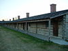
| Fort Robinson and Red Cloud Agency Fort Robinson Fort Robinson is a former U.S. Army fort and a present-day state park. Located in the Pine Ridge region of northwest Nebraska, it is west of Crawford on U.S. Route 20.- History :... |
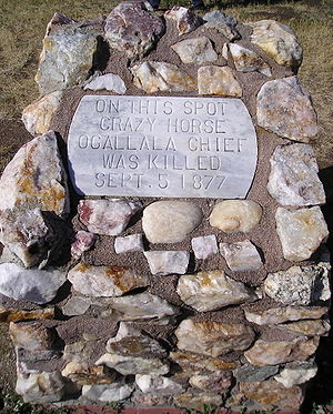 |
Crawford Crawford, Nebraska Crawford is a city in Dawes County, Nebraska, United States. The population was 997 at the 2010 census. It was incorporated in 1886 and was named for the late Captain Emmet Crawford who had previously been stationed at nearby Fort Robinson.-Geography:... |
Dawes Dawes County, Nebraska -National protected areas:*Nebraska National Forest *Oglala National Grassland *Pine Ridge National Recreation Area-Demographics:As of the census of 2000, there were 9,060 people, 3,512 households, and 2,086 families residing in the county. The population density was 6 people per square mile... and Sioux Sioux County, Nebraska -National protected areas:* Agate Fossil Beds National Monument* Nebraska National Forest * Oglala National Grassland -Demographics:... |
Site of an Indian Wars Indian Wars American Indian Wars is the name used in the United States to describe a series of conflicts between American settlers or the federal government and the native peoples of North America before and after the American Revolutionary War. The wars resulted from the arrival of European colonizers who... -era U.S. Army post. |
||
| HAZARD (Minesweeper) USS Hazard (AM-240) USS Hazard was an which served in the United States Navy during World War II.Hazard was launched on 1 October 1944 and was commissioned on 30 December 1944. The vessel was built by the Winslow Marine Railway and Shipbuilding Corporation of Winslow, Washington... |
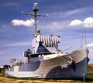 |
Omaha Omaha, Nebraska Omaha is the largest city in the state of Nebraska, United States, and is the county seat of Douglas County. It is located in the Midwestern United States on the Missouri River, about 20 miles north of the mouth of the Platte River... 41.27441°N 95.90127°W |
Douglas Douglas County, Nebraska -Demographics:As of the census of 2000, there were 463,585 people, 182,194 households, and 115,146 families residing in the county. The population density was 1,401 people per square mile . There were 192,672 housing units at an average density of 582 per square mile... |
A ship located in Omaha's Freedom Park Freedom Park (Omaha) Freedom Park is an outdoor park and museum at the Greater Omaha Marina on the bank of the Missouri River at 2497 Freedom Park Road in the East Omaha section of Omaha, Nebraska... . |
||
| Leary Site Leary Site Leary Site, also known as 25-RH-1 or Leary-Kelly Site is an archaeological site near Rulo, Nebraska.It was declared a National Historic Landmark in 1964.... |
Rulo Rulo, Nebraska -History:The 'Leary' excavation is the main 'Oneota'- reference to the Missouri River. The Oneota were a 'Mississippi' equal culture that flourished from 1000 to 1650 AD. Oneota are the ancestors of Siouane-speaking tribes. The site is located near present Rulo. Around 1640, the area around the... |
Richardson Richardson County, Nebraska -Demographics:As of the census of 2000, there were 9,531 people, 3,993 households, and 2,567 families residing in the county. The population density was 17 people per square mile . There were 4,560 housing units at an average density of 8 per square mile... |
An archaeological site Archaeological site An archaeological site is a place in which evidence of past activity is preserved , and which has been, or may be, investigated using the discipline of archaeology and represents a part of the archaeological record.Beyond this, the definition and geographical extent of a 'site' can vary widely,... . |
|||
| J. Sterling Morton House Arbor Lodge State Historical Park and Arboretum Arbor Lodge State Historical Park and Arboretum is a mansion, state park, and arboretum located at 2300 2nd Avenue, Nebraska City, Nebraska... |
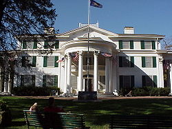 |
Nebraska City Nebraska City, Nebraska Nebraska City is a city in Otoe County, Nebraska, United States. The population was 7,228 at the 2000 census. It is the county seat of Otoe County... |
Otoe Otoe County, Nebraska -History:Otoe County was formed in 1854. It was named after the Otoe Indian tribe.-Demographics:As of the census of 2000, there were 15,396 people, 6,060 households, and 4,229 families residing in the county. The population density was 25 people per square mile . There were 6,567 housing units... |
The home J. Sterling Morton and the National Arbor Day Foundation National Arbor Day Foundation The Arbor Day Foundation is the world's oldest and largest tree-planting organization. The foundation began September 3, 1971 with a mission "to inspire people to plant, nurture, and celebrate trees". The Foundation is supported by donations, selling trees and merchandise, and by corporate sponsors... . |
||
| Nebraska State Capitol Nebraska State Capitol The Nebraska State Capitol, located in Lincoln, Nebraska, is the house of the Nebraska Legislature and houses other offices of the government of the U.S. state of Nebraska.... |
Lincoln Lincoln, Nebraska The City of Lincoln is the capital and the second-most populous city of the US state of Nebraska. Lincoln is also the county seat of Lancaster County and the home of the University of Nebraska. Lincoln's 2010 Census population was 258,379.... 40.809175°N 96.700495°W |
Lancaster Lancaster County, Nebraska -Demographics:As of the census of 2000, there were 250,291 people, 99,187 households, and 60,702 families residing in the county. The population density was 298 people per square mile . There were 104,217 housing units at an average density of 124 per square mile... |
The seat of the Government of Nebraska. | |||
| George W. Norris House George W. Norris House Senator George William Norris House, also known as George W. Norris House, is a house built in 1899 in McCook, Nebraska. It was a home of U.S. Senator George W... |
McCook McCook, Nebraska McCook is a city in Red Willow County, Nebraska, United States. The population was 7,994 at the 2000 census. It is the county seat of Red Willow County... 40.20388°N 100.62572°W |
Red Willow Red Willow County, Nebraska -History:Red Willow County was formed in 1873. It was named after the Red Willow Creek.-Demographics:As of the census of 2000, there were 11,448 people, 4,710 households, and 3,188 families residing in the county. The population density was 16 people per square mile . There were 5,278 housing... |
Home of U.S. Senator George W. Norris. | |||
| Palmer Site Palmer Site Palmer Site, also known as Skidi Pawnee Village, is an archeological site near Palmer, Nebraska.It was declared a National Historic Landmark in 1964.... |
 |
Palmer Palmer, Nebraska Palmer is a village in Merrick County, Nebraska, United States. The population was 472 at the 2000 census. It is part of the Grand Island, Nebraska Micropolitan Statistical Area.-Geography:Palmer is located at .... |
Howard Howard County, Nebraska -History:Howard County was formed in 1871. It was named after the Union General Oliver Otis Howard.-Demographics:As of the census of 2000, there were 6,567 people, 2,546 households, and 1,797 families residing in the county. The population density was 12 people per square mile . There were 2,782... and Merrick Merrick County, Nebraska -Demographics:As of the census of 2000, there were 8,204 people, 3,209 households, and 2,307 families residing in the county. The population density was 17 people per square mile . There were 3,649 housing units at an average density of 8 per square mile... |
An archaeological site Archaeological site An archaeological site is a place in which evidence of past activity is preserved , and which has been, or may be, investigated using the discipline of archaeology and represents a part of the archaeological record.Beyond this, the definition and geographical extent of a 'site' can vary widely,... . |
||
| Dr. Susan LaFlesche Picotte Memorial Hospital Dr. Susan LaFlesche Picotte Memorial Hospital -External links:*, at Historic American Building Survey*, from a National American Indian Heritage Month feature at the National Park Service... |
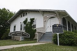 |
Walthill Walthill, Nebraska Walthill is a village in Thurston County, Nebraska, United States, within the Omaha Reservation. The population was 909 at the 2000 census.-Geography:Walthill is located at... 42.15154°N 96.50613°W |
Thurston Thurston County, Nebraska -History:Varying cultures of indigenous peoples lived along the rivers for thousands of years before European encounter.Thurston County was organized by European Americans in 1889 from land that had been divided between Dakota and Burt counties since the dissolution of Blackbird County in 1879. It... |
Hospital founded by Susan La Flesche Picotte Susan La Flesche Picotte Dr. Susan La Flesche Picotte was the first American Indian woman to become a physician in the United States. She grew up with her parents on the Omaha Reservation. She went to college at the Hampton Institute and got her medical degree at the Woman's Medical College of Pennsylvania in Philadelphia... , the first American Indian Native Americans in the United States Native Americans in the United States are the indigenous peoples in North America within the boundaries of the present-day continental United States, parts of Alaska, and the island state of Hawaii. They are composed of numerous, distinct tribes, states, and ethnic groups, many of which survive as... physician and one of the first female physicians in the U.S. |
||
| Pike Pawnee Village Site | Guide Rock Guide Rock, Nebraska Guide Rock is a village in Webster County, Nebraska, United States. The population was 245 at the 2000 census. The town was the first settlement in Webster County, with the first white settlers arriving in 1870. The town was named after Guide Rock, a hill on the opposite bank of the Republican River... |
Webster Webster County, Nebraska -History:Webster County was formed in 1871. It was named after the statesman Daniel Webster.-Demographics:As of the census of 2000, there were 4,061 people, 1,708 households, and 1,118 families residing in the county. The population density was 7 people per square mile . There were 1,972 housing... |
Claimed for the U.S. by Captain Zebulon Pike Zebulon Pike Zebulon Montgomery Pike Jr. was an American officer and explorer for whom Pikes Peak in Colorado is named. As a United States Army captain in 1806-1807, he led the Pike Expedition to explore and document the southern portion of the Louisiana Purchase and to find the headwaters of the Red River,... during the Pike expedition Pike expedition The Pike Expedition was a military effort authorized by the United States government to explore the south and west of the recent Louisiana Purchase. Roughly contemporaneous with the Lewis and Clark Expedition, it was led by United States Army Captain Zebulon Pike, Jr... in 1806. |
|||
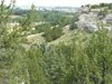
| Robidoux Pass Robidoux Pass Robidoux Pass, also known as Roubadeau Pass, Roubedeau Pass, Roubideau Pass, Roubidoux Passis and Roubadeau Pass Gap, is a gap passing through the Wildcat Hills near Scottsbluff, Nebraska about nine miles west of Gering, Nebraska. The gap was on the route of the historic Oregon or Emigrant Trail... |
 |
Gering Gering, Nebraska Gering is a city in Scotts Bluff County, Nebraska, United States. It is part of the Scottsbluff, Nebraska Micropolitan Statistical Area. The population was 7,751 at the 2000 census. It is the county seat of Scotts Bluff County.... |
Scotts Bluff Scotts Bluff County, Nebraska -National protected area:* North Platte National Wildlife Refuge* Scotts Bluff National Monument-Demographics:As of the census of 2000, there were 36,951 people, 14,887 households, and 10,167 families residing in the county. The population density was 50 people per square mile . There were 16,119... |
Pass that was part of the Oregon Trail Oregon Trail The Oregon Trail is a historic east-west wagon route that connected the Missouri River to valleys in Oregon and locations in between.After 1840 steam-powered riverboats and steamboats traversing up and down the Ohio, Mississippi and Missouri rivers sped settlement and development in the flat... from 1848 to 1851, when another pass became preferred. |
||
| Schultz Site Schultz Site Schultz Site, also known as Mira Creek Site or 25 Vy 1 is an archaeological site near North Loup, Nebraska. According to a statement of the site's significance:It was declared a National Historic Landmark in 1964.... |
North Loup North Loup, Nebraska North Loup is a village in Valley County, Nebraska, United States. The population was 339 at the 2000 census.-History:In 1871, a party of Seventh Day Baptists from Wisconsin explored Valley County for settlement sites. In May 1872, they established a community near what is now North Loup... |
Valley Valley County, Nebraska -Demographics:As of the census of 2000, there were 4,647 people, 1,965 households, and 1,298 families residing in the county. The population density was 8 people per square mile . There were 2,273 housing units at an average density of 4 per square mile... |
An archaeological site Archaeological site An archaeological site is a place in which evidence of past activity is preserved , and which has been, or may be, investigated using the discipline of archaeology and represents a part of the archaeological record.Beyond this, the definition and geographical extent of a 'site' can vary widely,... . |
|||
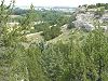
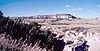
| Signal Butte Signal Butte Signal Butte, or site 25Sf1, is an archaeological site near Gering, Nebraska.It was declared a National Historic Landmark in 1961.At its designation, it was stated:... |
 |
Gering Gering, Nebraska Gering is a city in Scotts Bluff County, Nebraska, United States. It is part of the Scottsbluff, Nebraska Micropolitan Statistical Area. The population was 7,751 at the 2000 census. It is the county seat of Scotts Bluff County.... |
Scotts Bluff Scotts Bluff County, Nebraska -National protected area:* North Platte National Wildlife Refuge* Scotts Bluff National Monument-Demographics:As of the census of 2000, there were 36,951 people, 14,887 households, and 10,167 families residing in the county. The population density was 50 people per square mile . There were 16,119... |
|||
| Walker Gilmore Site Walker Gilmore Site Walker Gilmore Site is an archaeological site near Murray, Nebraska.It was designated a National Historic Landmark in 1964.In a statement of its significance at the time of its designation, the National Park Service stated:... |
Murray Murray, Nebraska Murray is a village in Cass County, Nebraska, United States. The population was 481 at the 2000 census.-Geography:Murray is located at .According to the United States Census Bureau, the village has a total area of , all of it land.... |
Cass Cass County, Nebraska -Other Geographical notes:Due to its proximity to Cass County, Iowa, and because both of those counties receive most of their broadcasts from Omaha, Nebraska, references to 'Cass County' must be frequently disambiguated, or result in confusion.-Demographics:... |
An archaeological site Archaeological site An archaeological site is a place in which evidence of past activity is preserved , and which has been, or may be, investigated using the discipline of archaeology and represents a part of the archaeological record.Beyond this, the definition and geographical extent of a 'site' can vary widely,... . |
|||
| Table notes: see below. | ||||||
Historic areas of the National Park System in Nebraska
National Monuments, National Historic Sites, and certain other areas listed in the National Park system are historic landmarks of national importance that are highly protected already, often before the inauguration of the NHL program in 1960, and are then often not also named NHLs per se. There are two of these in Nebraska. The National Park Service lists these two together with the NHLs in the state, They are:| Landmark name |
Image | Date established | Location | County | Description | |
|---|---|---|---|---|---|---|
| Homestead National Monument of America Homestead National Monument of America Homestead National Monument of America, a unit of the National Park System, commemorates passage of the Homestead Act of 1862, which allowed any qualified person to claim up to of federally owned land in exchange for five years of residence and the cultivation and improvement of the property... |
 |
Beatrice Beatrice, Nebraska Beatrice is a city in and the county seat of Gage County, Nebraska.Beatrice is located south of Lincoln on the Big Blue River. It is surrounded by agricultural country. The population was 12,459 at the 2010 census.-History:... |
Gage Gage County, Nebraska -History:Gage County was formed with land taken from the Oto in an 1854 treaty. It was named after the minister William D. Gage.-Demographics:As of the census of 2000, there were 22,993 people, 9,316 households, and 6,204 families residing in the county. The population density was 27 people per... |
The first claim made under the Homestead Act Homestead Act A homestead act is one of three United States federal laws that gave an applicant freehold title to an area called a "homestead" – typically 160 acres of undeveloped federal land west of the Mississippi River.... of 1862. |
||
| Scotts Bluff National Monument Scotts Bluff National Monument Scotts Bluff National Monument in western Nebraska includes an important 19th century landmark on the Oregon Trail and Mormon Trail. The National Monument contains multiple bluffs located on the south side of the North Platte River; it is named for one prominent bluff called Scotts Bluff, which... |
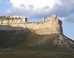 |
Gering Gering, Nebraska Gering is a city in Scotts Bluff County, Nebraska, United States. It is part of the Scottsbluff, Nebraska Micropolitan Statistical Area. The population was 7,751 at the 2000 census. It is the county seat of Scotts Bluff County.... |
Scotts Bluff Scotts Bluff County, Nebraska -National protected area:* North Platte National Wildlife Refuge* Scotts Bluff National Monument-Demographics:As of the census of 2000, there were 36,951 people, 14,887 households, and 10,167 families residing in the county. The population density was 50 people per square mile . There were 16,119... |
A landmark Landmarks of the Nebraska Territory Landmarks of the Nebraska Territory were important to settlers on the Oregon, California and Mormon trails. While the majority of the landmarks were close to the Platte River, others were spread across the state.-The trails:... on the Oregon Oregon Trail The Oregon Trail is a historic east-west wagon route that connected the Missouri River to valleys in Oregon and locations in between.After 1840 steam-powered riverboats and steamboats traversing up and down the Ohio, Mississippi and Missouri rivers sped settlement and development in the flat... and Mormon Trail Mormon Trail The Mormon Trail or Mormon Pioneer Trail is the 1,300 mile route that members of The Church of Jesus Christ of Latter-day Saints traveled from 1846 to 1868... s. |
||
See also
- List of Registered Historic Places in Nebraska
- List of National Historic Landmarks by state
- Landmarks in Omaha, Nebraska
External links
- National Historic Landmark Program at the National Park ServiceNational Park ServiceThe National Park Service is the U.S. federal agency that manages all national parks, many national monuments, and other conservation and historical properties with various title designations...
- Lists of National Historic Landmarks