
Lingmoor Fell
Encyclopedia
Lingmoor Fell is a fell
in the English Lake District
, situated eight kilometres west of Ambleside
. The fell reaches a modest height of 469 m (1,540 ft) and divides the valleys of Great Langdale
and Little Langdale
. The fell's name originates from the Old Norse
word lyng meaning “heather covered”. The actual summit of the fell is named as Brown How on Ordnance Survey
maps.
of 245 metres (for such a small fell) making it a Marilyn
hill. Lingmoor Fell has a subsidiary top, known as Side Pike (362 m, 1,187 ft) which lies 1.5 kilometres to the north west , it is a fine rock tower that is only accessible from the west and south. Walkers wishing to visit Side Pike from Lingmoor Fell are blocked by unassailable crags and must traverse round to easier slopes to the south.
The fell's northern and eastern flanks are clothed in deciduous woodland up to the 200 metre contour, there are also patches of heather and bracken on these lower slopes. Lingmoor Tarn, an attractive mountain lake (about 200 metres in length) with a couple of small islands, lies 600 metres north of the summit. One kilometre north of the summit of the fell stands another topographic feature, this is the detached rock pinnacle of Oak Howe Needle. The needle is part of Oak Howe Crag, a popular climbing
location on the fell, with over ten routes on Rhyolite
crags.
, overlying the dacitic
lapilli
-tuff
of the Lingmoor Fell Formation.
and Chapel Stile have long been quarried for its high quality Westmorland
green slate
, the Burlington quarry at Elterwater has been worked for over 300 years and is still in production today, turning out over 800 tonnes of slate annually. Many of the quarries have closed over the years and the crags are now used by rock climbers.
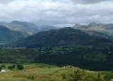
wall crossing it, the wall in fact traverses the entire spine of the fell, starting at the eastern foot and terminating abruptly at the crags below Side Pike in the west before re-commencing on the plateau. The view from the summit of Lingmoor Fell is highly regarded, there is a classic view of the Langdale Pikes and all of the high fells around the head of Great Langdale can be well appraised. The Coniston Fells
to the south west are also well seen.
Fell
“Fell” is a word used to refer to mountains, or certain types of mountainous landscape, in Scandinavia, the Isle of Man, and parts of northern England.- Etymology :...
in the English Lake District
Lake District
The Lake District, also commonly known as The Lakes or Lakeland, is a mountainous region in North West England. A popular holiday destination, it is famous not only for its lakes and its mountains but also for its associations with the early 19th century poetry and writings of William Wordsworth...
, situated eight kilometres west of Ambleside
Ambleside
Ambleside is a town in Cumbria, in North West England.Historically within the county of Westmorland, it is situated at the head of Windermere, England's largest lake...
. The fell reaches a modest height of 469 m (1,540 ft) and divides the valleys of Great Langdale
Great Langdale
Great Langdale is a valley in the Lake District National Park in the county of Cumbria, in the northwest of England. It is often simply referred to as Langdale, the epithet Great distinguishing it from the neighbouring valley of Little Langdale....
and Little Langdale
Little Langdale
Little Langdale is a valley in the Lake District, England containing Little Langdale Tarn and a hamlet also called Little Langdale. A second tarn, Blea Tarn, is in a hanging valley between Little Langdale and the larger Great Langdale to the north...
. The fell's name originates from the Old Norse
Old Norse
Old Norse is a North Germanic language that was spoken by inhabitants of Scandinavia and inhabitants of their overseas settlements during the Viking Age, until about 1300....
word lyng meaning “heather covered”. The actual summit of the fell is named as Brown How on Ordnance Survey
Ordnance Survey
Ordnance Survey , an executive agency and non-ministerial government department of the Government of the United Kingdom, is the national mapping agency for Great Britain, producing maps of Great Britain , and one of the world's largest producers of maps.The name reflects its creation together with...
maps.
Topography
Although it is surrounded by higher and better known fells, Lingmoor Fell is quite separate and distinct with no connecting ridges to other fells, giving it a considerable topographic prominenceTopographic prominence
In topography, prominence, also known as autonomous height, relative height, shoulder drop , or prime factor , categorizes the height of the mountain's or hill's summit by the elevation between it and the lowest contour line encircling it and no higher summit...
of 245 metres (for such a small fell) making it a Marilyn
Marilyn (hill)
A Marilyn is a mountain or hill in the United Kingdom, Republic of Ireland or Isle of Man with a relative height of at least 150 metres , regardless of absolute height or other merit...
hill. Lingmoor Fell has a subsidiary top, known as Side Pike (362 m, 1,187 ft) which lies 1.5 kilometres to the north west , it is a fine rock tower that is only accessible from the west and south. Walkers wishing to visit Side Pike from Lingmoor Fell are blocked by unassailable crags and must traverse round to easier slopes to the south.
The fell's northern and eastern flanks are clothed in deciduous woodland up to the 200 metre contour, there are also patches of heather and bracken on these lower slopes. Lingmoor Tarn, an attractive mountain lake (about 200 metres in length) with a couple of small islands, lies 600 metres north of the summit. One kilometre north of the summit of the fell stands another topographic feature, this is the detached rock pinnacle of Oak Howe Needle. The needle is part of Oak Howe Crag, a popular climbing
Climbing
Climbing is the activity of using one's hands and feet to ascend a steep object. It is done both for recreation and professionally, as part of activities such as maintenance of a structure, or military operations.Climbing activities include:* Bouldering: Ascending boulders or small...
location on the fell, with over ten routes on Rhyolite
Rhyolite
This page is about a volcanic rock. For the ghost town see Rhyolite, Nevada, and for the satellite system, see Rhyolite/Aquacade.Rhyolite is an igneous, volcanic rock, of felsic composition . It may have any texture from glassy to aphanitic to porphyritic...
crags.
Geology
The summit area is formed from a large sill of andesiteAndesite
Andesite is an extrusive igneous, volcanic rock, of intermediate composition, with aphanitic to porphyritic texture. In a general sense, it is the intermediate type between basalt and dacite. The mineral assemblage is typically dominated by plagioclase plus pyroxene and/or hornblende. Magnetite,...
, overlying the dacitic
Dacite
Dacite is an igneous, volcanic rock. It has an aphanitic to porphyritic texture and is intermediate in composition between andesite and rhyolite. The relative proportions of feldspars and quartz in dacite, and in many other volcanic rocks, are illustrated in the QAPF diagram...
lapilli
Lapilli
Lapilli is a size classification term for tephra, which is material that falls out of the air during a volcanic eruption or during some meteorite impacts. Lapilli means "little stones" in Latin. They are in some senses similar to ooids or pisoids in calcareous sediments.By definition lapilli range...
-tuff
Tuff
Tuff is a type of rock consisting of consolidated volcanic ash ejected from vents during a volcanic eruption. Tuff is sometimes called tufa, particularly when used as construction material, although tufa also refers to a quite different rock. Rock that contains greater than 50% tuff is considered...
of the Lingmoor Fell Formation.
Quarrying
Lingmoor Fell's north eastern slopes above the villages of ElterwaterElterwater
Elter Water is a small lake that lies half a mile south-east of the village of Elterwater. Both are situated in the valley of Great Langdale in the English Lake District...
and Chapel Stile have long been quarried for its high quality Westmorland
Westmorland
Westmorland is an area of North West England and one of the 39 historic counties of England. It formed an administrative county from 1889 to 1974, after which the entirety of the county was absorbed into the new county of Cumbria.-Early history:...
green slate
Slate
Slate is a fine-grained, foliated, homogeneous metamorphic rock derived from an original shale-type sedimentary rock composed of clay or volcanic ash through low-grade regional metamorphism. The result is a foliated rock in which the foliation may not correspond to the original sedimentary layering...
, the Burlington quarry at Elterwater has been worked for over 300 years and is still in production today, turning out over 800 tonnes of slate annually. Many of the quarries have closed over the years and the crags are now used by rock climbers.
Ascents
Lingmoor Fell can be climbed either from Elterwater in Great Langdale or from the Blea Tarn car park in Little Langdale (grid reference ). The latter route makes use of an old quarry track for much of the way. The Elterwater route can be slightly confusing in its early stages as there are a jumble of paths through the lower woodland and quarries, the route becomes clear once the open fell has been reached.Summit and View
The summit of the fell has a high dry stoneDry stone
Dry stone is a building method by which structures are constructed from stones without any mortar to bind them together. Dry stone structures are stable because of their unique construction method, which is characterized by the presence of a load-bearing facade of carefully selected interlocking...
wall crossing it, the wall in fact traverses the entire spine of the fell, starting at the eastern foot and terminating abruptly at the crags below Side Pike in the west before re-commencing on the plateau. The view from the summit of Lingmoor Fell is highly regarded, there is a classic view of the Langdale Pikes and all of the high fells around the head of Great Langdale can be well appraised. The Coniston Fells
Furness Fells
The Furness Fells are those hills and mountains in the Furness region of Cumbria, England. Historically part of Lancashire, the Furness Fells or High Furness is the name given to the upland part of Furness, that is, that part of Furness lying north of the line between Ulverston and Ireleth...
to the south west are also well seen.