
Limehouse Cut
Encyclopedia

Canal
Canals are man-made channels for water. There are two types of canal:#Waterways: navigable transportation canals used for carrying ships and boats shipping goods and conveying people, further subdivided into two kinds:...
in the East End
East End of London
The East End of London, also known simply as the East End, is the area of London, England, United Kingdom, east of the medieval walled City of London and north of the River Thames. Although not defined by universally accepted formal boundaries, the River Lea can be considered another boundary...
of London
London
London is the capital city of :England and the :United Kingdom, the largest metropolitan area in the United Kingdom, and the largest urban zone in the European Union by most measures. Located on the River Thames, London has been a major settlement for two millennia, its history going back to its...
, which linked the lower reaches of the River Lee Navigation
River Lee Navigation
The Lee Navigation is a canalised river incorporating the River Lea . Its course runs from Hertford Castle Weir all the way to the River Thames at Bow Creek. The first lock of the navigation is Hertford Lock the last being Bow Locks....
to the River Thames
River Thames
The River Thames flows through southern England. It is the longest river entirely in England and the second longest in the United Kingdom. While it is best known because its lower reaches flow through central London, the river flows alongside several other towns and cities, including Oxford,...
. It now connects to Limehouse Basin
Limehouse Basin
The Limehouse Basin in Limehouse, in the London Borough of Tower Hamlets provides a navigable link between the Regent's Canal and the River Thames, through the Limehouse Basin Lock. A basin in the north of Mile End, near Victoria Park connects with the Hertford Union Canal leading to the River Lee...
as a result of changes made in 1968.
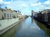
The Cut turns in a broad curve from Bow Locks
Bow Locks
Bow Locks is a set of bi-directional locks in the London Borough of Tower Hamlets. The locks link the tidal Bow Creek to the River Lee Navigation, which is a canalised river. These locks were first built in 1850 and then rebuilt in 1930, at the same time as the Prescott Channel was cut nearby...
, where the Lee Navigation meets Bow Creek
Bow Creek
Bow Creek is a long tidal estuary of the River Lea and is part of the Bow Back Rivers. Below Bow Locks the creek forms the boundary between the London Boroughs of Newham and Tower Hamlets, in east London....
; it then proceeds directly south-west for 2 miles (3.2 km) through the London Borough of Tower Hamlets
London Borough of Tower Hamlets
The London Borough of Tower Hamlets is a London borough to the east of the City of London and north of the River Thames. It is in the eastern part of London and covers much of the traditional East End. It also includes much of the redeveloped Docklands region of London, including West India Docks...
to Limehouse Basin.
History
The Limehouse Cut was authorised by the River Lee Act, an Act of Parliament obtained in 1766, and is therefore the oldest canal in London. It provides a short-cut from the River ThamesRiver Thames
The River Thames flows through southern England. It is the longest river entirely in England and the second longest in the United Kingdom. While it is best known because its lower reaches flow through central London, the river flows alongside several other towns and cities, including Oxford,...
at Limehouse Basin
Limehouse Basin
The Limehouse Basin in Limehouse, in the London Borough of Tower Hamlets provides a navigable link between the Regent's Canal and the River Thames, through the Limehouse Basin Lock. A basin in the north of Mile End, near Victoria Park connects with the Hertford Union Canal leading to the River Lee...
north-east to the River Lee Navigation
River Lee Navigation
The Lee Navigation is a canalised river incorporating the River Lea . Its course runs from Hertford Castle Weir all the way to the River Thames at Bow Creek. The first lock of the navigation is Hertford Lock the last being Bow Locks....
, avoiding the tortuous curves of the lower reaches of the River Lea at Bow Creek
Bow Creek
Bow Creek is a long tidal estuary of the River Lea and is part of the Bow Back Rivers. Below Bow Locks the creek forms the boundary between the London Boroughs of Newham and Tower Hamlets, in east London....
, and the need to wait for the tide to make the long detour round the Isle of Dogs
Isle of Dogs
The Isle of Dogs is a former island in the East End of London that is bounded on three sides by one of the largest meanders in the River Thames.-Etymology:...
. The Cut joins the Lea at Bromley-by-Bow
Bromley-by-Bow
Bromley-by-Bow, historically and officially Bromley, is a place in the London Borough of Tower Hamlets. It is an inner-city district situated east north-east of Charing Cross.-Toponymy:...
. Before 1968 the Cut enjoyed its own direct link to the Thames, but this exit lock was replaced when a short length of new canal was constructed to link the Cut with the Regent's Canal
Regent's Canal
Regent's Canal is a canal across an area just north of central London, England. It provides a link from the Paddington arm of the Grand Union Canal, just north-west of Paddington Basin in the west, to the Limehouse Basin and the River Thames in east London....
Dock, now known as Limehouse Basin. The link to the Thames has since been infilled. There was a link to the dock in the 19th century, but this had been removed when the dock was extended.
The cut was built for sailing barges, and can accommodate vessels which are 88 ft by 19 ft (26.8m x 5.8m). Headroom is limited to 7 ft (2.1m). The lock from Limehouse Basin to the Thames was originally a ship lock, but has been replaced with a smaller one.
Bow Locks
Bow Locks
Bow Locks is a set of bi-directional locks in the London Borough of Tower Hamlets. The locks link the tidal Bow Creek to the River Lee Navigation, which is a canalised river. These locks were first built in 1850 and then rebuilt in 1930, at the same time as the Prescott Channel was cut nearby...
were originally tidal, replenishing Limehouse Cut and the southern section of the Lee Navigation at high tide. The Cut could be isolated from the level of the Navigation by the Bromley Stop Lock
Bromley Stop Lock
The Bromley Stop Lock, in the London Borough of Tower Hamlets, was a single-gate lock that could be closed to cut off a section of canal for maintenance. The lock gate was situated near the junction of Limehouse Cut and the River Lee Navigation, by Bow Locks...
; and from Limehouse Basin
Limehouse Basin
The Limehouse Basin in Limehouse, in the London Borough of Tower Hamlets provides a navigable link between the Regent's Canal and the River Thames, through the Limehouse Basin Lock. A basin in the north of Mile End, near Victoria Park connects with the Hertford Union Canal leading to the River Lee...
by the Britannia Stop Lock
Britannia Stop Lock
The Britannia Stop Lock was a single-gate lock, in the London Borough of Tower Hamlets, that could be closed to cut off a section of canal for drainage and maintenance.The lock gate was situated at the entrance of Limehouse Cut to Limehouse Basin...
. Today, the level at Bow Lock is maintained at the same level as Limehouse Basin, with the result that the two stop locks are redundant, and have been largely removed.
Today
Hertford Union Canal
The Hertford Union Canal or Duckett's Canal is a short stretch of canal in the London Borough of Tower Hamlets in east London. It connects the Regent's Canal to the Lee Navigation. It was opened in 1830 but quickly proved to be a commercial failure...
, River Lee Navigation and the Limehouse Cut form a square, for a distance of seven to eight miles which can be walked or cycled. These scenic towpath
Towpath
A towpath is a road or trail on the bank of a river, canal, or other inland waterway. The purpose of a towpath is to allow a land vehicle, beasts of burden, or a team of human pullers to tow a boat, often a barge...
s cut across roads and railways in the area, providing a distinct viewpoint.
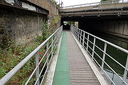
Access on foot along the Limehouse Cut was difficult in the area below the Blackwall Tunnel approach road, but is now possible as a result of an innovative scheme to create a floating towpath. This was opened in July 2003 and consists of 60 floating pontoons, creating a 240 metres (262 yd) walkway complete with green glowing edges.
The Cut is administered by British Waterways
British Waterways
British Waterways is a statutory corporation wholly owned by the government of the United Kingdom, serving as the navigation authority in England, Scotland and Wales for the vast majority of the canals as well as a number of rivers and docks...
.
See also
- Spratt's ComplexSpratt's ComplexThe Spratt's Complex in Poplar is an old pet food factory that has been converted into approximately 150 live/work units. It was one of the first warehouse conversions in London. It is situated on Morris Road between the DLR stations of Langdon Park and Devons Road.The complex is called after the...
, an adjacent warehouse conversion including a large building called Limehouse Cut - Canals of the United KingdomCanals of the United KingdomThe canals of the United Kingdom are a major part of the network of inland waterways in the United Kingdom. They have a colourful history, from use for irrigation and transport, through becoming the focus of the Industrial Revolution, to today's role for recreational boating...
- History of the British canal systemHistory of the British canal systemThe British canal system of water transport played a vital role in the United Kingdom's Industrial Revolution at a time when roads were only just emerging from the medieval mud and long trains of pack horses were the only means of "mass" transit by road of raw materials and finished products The...