
Leverett, Massachusetts
Encyclopedia
Leverett is a town
in Franklin County
, Massachusetts
, United States
. The population was 1,663 as of the 2000 census. It is part of the Springfield, Massachusetts
Metropolitan Statistical Area
.
to become their own town in 1774. The town was named for John Leverett
, the twentieth governor of the Massachusetts Bay Colony
.
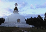
In 1985, a Buddhist
monastic order called Nipponzan Myohoji erected a large monument in Leverett. This structure, known as the New England Peace Pagoda
, is considered the first of its kind in North America.
, the town has a total area of 23 square miles (59.6 km²), of which 22.9 square miles (59.3 km²) are land and 0.1 square mile (0.258998811 km²) (0.61%) is water. Leverett is located on the edge of the Pioneer Valley
and the hills of northwestern Massachusetts, just east of the Connecticut River
. The southwestern corner of town is relatively flat plains, while the rest is dominated by hills, the tallest of which is Brushy Mountain, with an elevation of 1260 feet (384 m).
Several brooks drain through the town, all heading toward the Connecticut River. Leverett Pond is the town's largest body of water, lying near the center of town. A small part of Mount Toby State Forest crosses into the town from the west. The town's most famous geological feature, however, is Rattlesnake Gutter
, a boulder-filled chasm near the geographic center of town.
Leverett is located along the southern border of Franklin County, north of Hampshire County
. The town is bordered by Montague
to the north; Wendell
to the northeast; Shutesbury
to the east; Amherst
to the south; and Sunderland
to the west. The town is centered on four small villages, including Leverett Center, East Leverett, North Leverett and Moores Corner. North Leverett begins at the intersection of Montague Road and Cave Hill Road, extending north to the Montague
and Wendell
borders. From Leverett Center, Leverett is 14 miles (22.5 km) south-southeast of the county seat of Greenfield
, 27 miles (43.5 km) north of Springfield
, and 86 miles (138.4 km) west of Boston
.
of 2000, there were 1,663 people, in 632 households, and 448 families residing in the town. The population density
was 72.8 people per square mile (28.1/km²). There were 648 housing units at an average density of 28.4 per square mile (10.9/km²). The racial makeup of the town was 95.31% White; 0.24% African American; 0.54% Native American; 1.38% Asian; 1.62% from other races
; and 0.90% from two or more races. Hispanic or Latino of any race were 1.44% of the population.
Of the 632 households, 34.0% had children under the age of 18 living in them; 58.5% were married couples
living together; 9.2% had a female householder with no husband present; and 29.0% were non-families. 19.9% of all households were made up of individuals and 5.2% had someone living alone who was 65 years of age or older. The average household size was 2.58 and the average family size was 2.92.
In the town the population was spread out with 23.3% under the age of 18, 7.8% from 18 to 24; 22.1% from 25 to 44, 35.7% from 45 to 64; and 11.2% who were 65 years of age or older. The median age was 43 years. For every 100 females, there were 99.9 males. For every 100 females age 18 and over, there were 94.4 males.
The median income for a household was $63,203, and the median income for a family was $73,333. Males had a median income of $45,078 versus $36,607 for females. The per capita income
for the town was $31,891. About 1.6% of families and 5.4% of the population were below the poverty line, including 2.1% of those under age 18 and 5.0% of those age 65 or over.
, lies west of town, across the Connecticut River
. The only state route to pass through town, Route 63, runs through the western side of town, heading from Amherst into Montague. The route is closely mirrored by the New England Central Railroad
line, which carries the Amtrak
Vermonter
from Springfield towards Vermont. There is no stop in town, the nearest being in neighboring Amherst. A connecting bus route between Greenfield and Amherst, provided by the Franklin Regional Transit Authority (FRTA), passes through the town, but there are no regularly scheduled stops. The nearest general aviation airport is Turners Falls Airport
in Montague, and the nearest national air service is at Bradley International Airport
in Connecticut.
New England town
The New England town is the basic unit of local government in each of the six New England states. Without a direct counterpart in most other U.S. states, New England towns are conceptually similar to civil townships in other states, but are incorporated, possessing powers like cities in other...
in Franklin County
Franklin County, Massachusetts
-Demographics:As of the census of 2000, there were 71,535 people, 29,466 households, and 18,416 families residing in the county. The population density was 102 people per square mile . There were 31,939 housing units at an average density of 46 per square mile...
, Massachusetts
Massachusetts
The Commonwealth of Massachusetts is a state in the New England region of the northeastern United States of America. It is bordered by Rhode Island and Connecticut to the south, New York to the west, and Vermont and New Hampshire to the north; at its east lies the Atlantic Ocean. As of the 2010...
, United States
United States
The United States of America is a federal constitutional republic comprising fifty states and a federal district...
. The population was 1,663 as of the 2000 census. It is part of the Springfield, Massachusetts
Springfield, Massachusetts
Springfield is the most populous city in Western New England, and the seat of Hampden County, Massachusetts, United States. Springfield sits on the eastern bank of the Connecticut River near its confluence with three rivers; the western Westfield River, the eastern Chicopee River, and the eastern...
Metropolitan Statistical Area
Springfield, Massachusetts metropolitan area
The Springfield Metropolitan Area is a region that is socio-economically and culturally tied to the City of Springfield, Massachusetts. The U.S. Office of Management and Budget defines the Springfield metropolitan statistical area as consisting of three counties in Western Massachusetts. As of...
.
History
According to the Massachusetts FCCC, Leverett was first settled in the 17th century when pioneers developed the Swampfield Plantation. The first permanent settlement, however, was not established until 1750, and the settlers officially petitioned SunderlandSunderland, Massachusetts
Sunderland is a town in Franklin County, Massachusetts, part of the Pioneer Valley. The population was 3,777 as of the 2000 census. It is part of the Springfield, Massachusetts Metropolitan Statistical Area....
to become their own town in 1774. The town was named for John Leverett
John Leverett
John Leverett was an English colonial magistrate, merchant, soldier and governor of the Massachusetts Bay Colony. Born in England, he came to Massachusetts as a teenager. He was a leading merchant in the colony, and served in its military...
, the twentieth governor of the Massachusetts Bay Colony
Massachusetts Bay Colony
The Massachusetts Bay Colony was an English settlement on the east coast of North America in the 17th century, in New England, situated around the present-day cities of Salem and Boston. The territory administered by the colony included much of present-day central New England, including portions...
.
In 1985, a Buddhist
Buddhism
Buddhism is a religion and philosophy encompassing a variety of traditions, beliefs and practices, largely based on teachings attributed to Siddhartha Gautama, commonly known as the Buddha . The Buddha lived and taught in the northeastern Indian subcontinent some time between the 6th and 4th...
monastic order called Nipponzan Myohoji erected a large monument in Leverett. This structure, known as the New England Peace Pagoda
Peace Pagoda
A Peace Pagoda is a Buddhist stupa designed to provide a focus for people of all races and creeds, and to help unite them in their search for world peace. Most have been built under the guidance of Nichidatsu Fujii , a Buddhist monk from Japan and founder of the Nipponzan-Myōhōji Buddhist Order...
, is considered the first of its kind in North America.
Geography
According to the United States Census BureauUnited States Census Bureau
The United States Census Bureau is the government agency that is responsible for the United States Census. It also gathers other national demographic and economic data...
, the town has a total area of 23 square miles (59.6 km²), of which 22.9 square miles (59.3 km²) are land and 0.1 square mile (0.258998811 km²) (0.61%) is water. Leverett is located on the edge of the Pioneer Valley
Pioneer Valley
The Pioneer Valley is the colloquial name for the U.S. Commonwealth of Massachusetts's portion of the Connecticut River Valley. The Pioneer Valley consists of three counties in Massachusetts which collectively feature much of New England's most fertile farmland...
and the hills of northwestern Massachusetts, just east of the Connecticut River
Connecticut River
The Connecticut River is the largest and longest river in New England, and also an American Heritage River. It flows roughly south, starting from the Fourth Connecticut Lake in New Hampshire. After flowing through the remaining Connecticut Lakes and Lake Francis, it defines the border between the...
. The southwestern corner of town is relatively flat plains, while the rest is dominated by hills, the tallest of which is Brushy Mountain, with an elevation of 1260 feet (384 m).
Several brooks drain through the town, all heading toward the Connecticut River. Leverett Pond is the town's largest body of water, lying near the center of town. A small part of Mount Toby State Forest crosses into the town from the west. The town's most famous geological feature, however, is Rattlesnake Gutter
Rattlesnake Gutter
Rattlesnake Gutter is a scenic boulder filled chasm, 3/4 mile long and 1/8 mile wide, located in Leverett, Massachusetts. The origins of the gutter are uncertain, but theories include:* A subglacial meltwater channel...
, a boulder-filled chasm near the geographic center of town.
Leverett is located along the southern border of Franklin County, north of Hampshire County
Hampshire County, Massachusetts
-Demographics:As of the census of 2000, there were 152,251 people, 55,991 households, and 33,818 families residing in the county. The population density was 288 people per square mile . There were 58,644 housing units at an average density of 111 per square mile...
. The town is bordered by Montague
Montague, Massachusetts
Montague is a town in Franklin County, Massachusetts, United States. The population was 8,489 at the 2000 census. It is part of the Springfield, Massachusetts metropolitan statistical area....
to the north; Wendell
Wendell, Massachusetts
Wendell is a town in Franklin County, Massachusetts, United States. The population was 986 at the 2000 census. It is part of the Springfield, Massachusetts Metropolitan Statistical Area.- History :...
to the northeast; Shutesbury
Shutesbury, Massachusetts
Shutesbury is a town in Franklin County, Massachusetts, United States. The population was 1,810 as of the 2000 census. It is part of the Springfield, Massachusetts Metropolitan Statistical Area.- History :...
to the east; Amherst
Amherst, Massachusetts
Amherst is a town in Hampshire County, Massachusetts, United States in the Connecticut River valley. As of the 2010 census, the population was 37,819, making it the largest community in Hampshire County . The town is home to Amherst College, Hampshire College, and the University of Massachusetts...
to the south; and Sunderland
Sunderland, Massachusetts
Sunderland is a town in Franklin County, Massachusetts, part of the Pioneer Valley. The population was 3,777 as of the 2000 census. It is part of the Springfield, Massachusetts Metropolitan Statistical Area....
to the west. The town is centered on four small villages, including Leverett Center, East Leverett, North Leverett and Moores Corner. North Leverett begins at the intersection of Montague Road and Cave Hill Road, extending north to the Montague
Montague, Massachusetts
Montague is a town in Franklin County, Massachusetts, United States. The population was 8,489 at the 2000 census. It is part of the Springfield, Massachusetts metropolitan statistical area....
and Wendell
Wendell, Massachusetts
Wendell is a town in Franklin County, Massachusetts, United States. The population was 986 at the 2000 census. It is part of the Springfield, Massachusetts Metropolitan Statistical Area.- History :...
borders. From Leverett Center, Leverett is 14 miles (22.5 km) south-southeast of the county seat of Greenfield
Greenfield, Massachusetts
Greenfield is a city in Franklin County, Massachusetts, United States. The population was 17,456 at the 2010 census. It is the county seat of Franklin County. Greenfield is home to Greenfield Community College, the Pioneer Valley Symphony Orchestra, and the Franklin County Fair...
, 27 miles (43.5 km) north of Springfield
Springfield, Massachusetts
Springfield is the most populous city in Western New England, and the seat of Hampden County, Massachusetts, United States. Springfield sits on the eastern bank of the Connecticut River near its confluence with three rivers; the western Westfield River, the eastern Chicopee River, and the eastern...
, and 86 miles (138.4 km) west of Boston
Boston
Boston is the capital of and largest city in Massachusetts, and is one of the oldest cities in the United States. The largest city in New England, Boston is regarded as the unofficial "Capital of New England" for its economic and cultural impact on the entire New England region. The city proper had...
.
Demographics
As of the censusCensus
A census is the procedure of systematically acquiring and recording information about the members of a given population. It is a regularly occurring and official count of a particular population. The term is used mostly in connection with national population and housing censuses; other common...
of 2000, there were 1,663 people, in 632 households, and 448 families residing in the town. The population density
Population density
Population density is a measurement of population per unit area or unit volume. It is frequently applied to living organisms, and particularly to humans...
was 72.8 people per square mile (28.1/km²). There were 648 housing units at an average density of 28.4 per square mile (10.9/km²). The racial makeup of the town was 95.31% White; 0.24% African American; 0.54% Native American; 1.38% Asian; 1.62% from other races
Race (United States Census)
Race and ethnicity in the United States Census, as defined by the Federal Office of Management and Budget and the United States Census Bureau, are self-identification data items in which residents choose the race or races with which they most closely identify, and indicate whether or not they are...
; and 0.90% from two or more races. Hispanic or Latino of any race were 1.44% of the population.
Of the 632 households, 34.0% had children under the age of 18 living in them; 58.5% were married couples
Marriage
Marriage is a social union or legal contract between people that creates kinship. It is an institution in which interpersonal relationships, usually intimate and sexual, are acknowledged in a variety of ways, depending on the culture or subculture in which it is found...
living together; 9.2% had a female householder with no husband present; and 29.0% were non-families. 19.9% of all households were made up of individuals and 5.2% had someone living alone who was 65 years of age or older. The average household size was 2.58 and the average family size was 2.92.
In the town the population was spread out with 23.3% under the age of 18, 7.8% from 18 to 24; 22.1% from 25 to 44, 35.7% from 45 to 64; and 11.2% who were 65 years of age or older. The median age was 43 years. For every 100 females, there were 99.9 males. For every 100 females age 18 and over, there were 94.4 males.
The median income for a household was $63,203, and the median income for a family was $73,333. Males had a median income of $45,078 versus $36,607 for females. The per capita income
Per capita income
Per capita income or income per person is a measure of mean income within an economic aggregate, such as a country or city. It is calculated by taking a measure of all sources of income in the aggregate and dividing it by the total population...
for the town was $31,891. About 1.6% of families and 5.4% of the population were below the poverty line, including 2.1% of those under age 18 and 5.0% of those age 65 or over.
Transportation
There are no interstates or limited-access highways in the town; the nearest, Interstate 91Interstate 91
Interstate 91 is an Interstate Highway in the New England region of the United States. It provides the primary north–south thoroughfare in the western part of New England...
, lies west of town, across the Connecticut River
Connecticut River
The Connecticut River is the largest and longest river in New England, and also an American Heritage River. It flows roughly south, starting from the Fourth Connecticut Lake in New Hampshire. After flowing through the remaining Connecticut Lakes and Lake Francis, it defines the border between the...
. The only state route to pass through town, Route 63, runs through the western side of town, heading from Amherst into Montague. The route is closely mirrored by the New England Central Railroad
New England Central Railroad
The New England Central Railroad is a subsidiary of RailAmerica that began operations in 1995. It runs from New London, Connecticut, to Alburgh, Vermont, a distance of .-History:...
line, which carries the Amtrak
Amtrak
The National Railroad Passenger Corporation, doing business as Amtrak , is a government-owned corporation that was organized on May 1, 1971, to provide intercity passenger train service in the United States. "Amtrak" is a portmanteau of the words "America" and "track". It is headquartered at Union...
Vermonter
Vermonter
Amtrak's Vermonter is a 611-mile passenger train service between St. Albans , New York City and Washington, D.C. One trip runs in each direction per day....
from Springfield towards Vermont. There is no stop in town, the nearest being in neighboring Amherst. A connecting bus route between Greenfield and Amherst, provided by the Franklin Regional Transit Authority (FRTA), passes through the town, but there are no regularly scheduled stops. The nearest general aviation airport is Turners Falls Airport
Turners Falls Airport
Turners Falls Airport is a public airport located three miles north of the central business district of Montague, a town in Franklin County, Massachusetts, USA. The airport is owned by the Town of Montague...
in Montague, and the nearest national air service is at Bradley International Airport
Bradley International Airport
Bradley International Airport is a joint civil-military public airport located in Windsor Locks on the border with East Granby and Suffield, in Hartford County, Connecticut, United States. It is owned by the State of Connecticut....
in Connecticut.