
Lenoir City, Tennessee
Encyclopedia
Lenoir City is a city in Loudon County, Tennessee
, United States
. Its population was 8,642 at the 2010 census
. It is included in the Knoxville Metropolitan Area
.
Lenoir City is located in eastern Tennessee
, southwest of Knoxville
, on the Tennessee River
. Fort Loudoun Dam
is nearby.
, which runs roughly parallel to the river shore, traverses the city east-to-west; U.S. Route 321
, which crosses Fort Loudon Dam south of the city, traverses the city north-to-south. Interstate 75
and U.S. Route 70
intersect US-321 in the northern part of the city. US-321 terminates at Interstate 40
just north of the city.
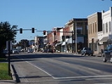
Lenoir City is traditionally spread out along US-11, west of the road's junction with US-321. This section of the city still roughly follows a grid plan laid out in the 1890s. In recent decades, Lenoir City has annexed a 5 miles (8 km) corridor of land along US-321 between its US-11 intersection and US-70 intersection. This corridor contains the city's newer, commecial area that caters to the high volume of traffic brought to the area by I-75 and I-40.
According to the United States Census Bureau
, the city has a total area of 6.2 square miles (16.1 km²), of which, 6.2 square miles (16.1 km²) of it is land and 0.04 square mile (0.1035995244 km²) of it (0.48%) is water.
were living in the Lenoir City area for thousands of years before the arrival of the first European settlers. On Bussell Island
, which lies across the Tennessee River to the south, archaeologists have discovered evidence of habitation dating to as early as the Archaic Period (8000–1000 B.C.). The island is also believed to have been the location of "Coste," a village visited by Hernando de Soto
in 1540. The Cherokee
called the Lenoir City area Wa'ginsi, and believed it to be the home of a large serpent that brought bad luck to anyone who saw it. By the early 19th century, an early East Tennessee pioneer, Judge David Campbell, had laid claim to part of what is now Lenoir City, where he had built a log cabin and a gristmill
.
as payment for his services in the American Revolutionary War
. David Campbell and another early settler, Alexander Outlaw, filed a case against Lenoir in court, arguing they had already laid claim to parts of the Lenoir tract. After the case was settled in favor of Lenoir in 1809, Lenoir deeded the tract to his son, William Ballard Lenoir
(1775–1852), who in 1810 moved to the tract and established a large plantation. Along with agricultural pursuits, which included producing hams from a herd of Berkshire hogs
, Lenoir operated several small-scale industries, including a sawmill and flour mill. In the early 1830s, the Lenoir Cotton Mill
— one of the earliest in the South— was completed along the banks of Town Creek.
After Lenoir's death, his estate was divided up among his children. His sons formed the William Lenoir and Brothers Company to manage the family's businesses. When the railroad reached the Lenoir estate in 1855, a depot was constructed, and the community of Lenoir Station developed around it.
During the Civil War, the Lenoirs supported the Confederacy
, due in part to associations with Confederate-leaning business interests in Knoxville (one of William Ballard Lenoir's sons was married to the daughter of Knoxville historian and banker, J. G. M. Ramsey
, who was an ardent Confederate). On June 20, 1863, a Union
scouting expedition led by General William P. Sanders
arrived at Lenoir Station after having failed to destroy the railroad trestle at Loudon
. Sanders burned the depot as well as the Lenoirs' sawmill and flour mill. He spared the cotton mill, however, since there were few such mills in the area to provide cloth for the army, and because the Lenoirs were fellow Masons
.
 In the late 1880s, an abundance of financial capital, the popularity of social theories regarding planned cities, and a thriving coal mining industry in East Tennessee's Cumberland Plateau
region led to the establishment of a number of company town
s throughout the Upper Tennessee Valley, most of which were funded by investors from the northeast or Knoxville. In 1889, Knoxville railroad magnate Charles McClung McGhee
and his friend and associate, Edward J. Sanford
, formed the Lenoir City Company, believing the Lenoir estate would be the ideal location for such a town. The company incorporated in April 1890 with $800,000 in stock, and purchased the Lenoir estate— which then consisted of 2700 acres (1,092.7 ha)— for $300 per acre. When the company issued the stock to the public, the investors each received stock in the company and a lot in the planned town.
Lenoir City was laid out in a grid pattern with four quadrants, west of Town Creek and north of the railroad tracks. The city's northwest quadrant would be a middle class and affluent residential area, whereas the northeast quadrant would be for the city's wage-workers. The southwest quadrant would contain blast furnaces, steel works, and other large factories, while the southeast quadrant would contain woodworking, furniture, and canning factories. Influenced by late 19th-century reform movements that stressed health and temperance, several lots were set aside for public parks, and a large garden area was planned between the railroad tracks and the river.
The Lenoir City Company struggled due to a recession that froze financial markets in the early 1890s. By 1892, the company had only sold 144 of the town's 3,448 lots. McGhee and Sanford persisted, however, and while it never developed in the grand fashion conceived, Lenoir City nevertheless survived. McGhee convinced a rail car company to open a factory in Lenoir City, and a short time later a knitting mill was established. Both establishments still employed several hundred workers in 1910.
in the 1950s and 1960s brought about the construction of I-75 and I-40— two trans-national highways that intersect just northeast Lenoir City. U.S. Highway 321 was built through Lenoir City in the 1980s primarily to provide greater access to the Great Smoky Mountains National Park
, some 40 miles (64.4 km) down the road in Blount County.
of 2000, there were 6,819 people, 2,910 households, and 1,815 families residing in the city. The population density
was 1,099.2 people per square mile (424.7/km²). There were 3,228 housing units at an average density of 520.3 per square mile (201.0/km²). The racial makeup of the city was 92.40% White, 1.09% African American, 0.44% Native American, 0.12% Asian, 0.06% Pacific Islander, 4.36% from other races
, and 1.54% from two or more races. Hispanic or Latino of any race were 6.00% of the population.
There were 2,910 households out of which 30.4% had children under the age of 18 living with them, 44.5% were married couples
living together, 13.8% had a female householder with no husband present, and 37.6% were non-families. 33.2% of all households were made up of individuals and 14.7% had someone living alone who was 65 years of age or older. The average household size was 2.33 and the average family size was 2.95.
In the city the population was spread out with 25.0% under the age of 18, 9.3% from 18 to 24, 30.3% from 25 to 44, 20.8% from 45 to 64, and 14.6% who were 65 years of age or older. The median age was 35 years. For every 100 females there were 90.3 males. For every 100 females age 18 and over, there were 85.5 males.
The median income for a household in the city was $28,889, and the median income for a family was $33,462. Males had a median income of $27,229 versus $20,744 for females. The per capita income
for the city was $16,632. About 13.4% of families and 16.0% of the population were below the poverty line, including 22.1% of those under age 18 and 8.9% of those age 65 or over.
through eighth) find themselves transferring to the city school system upon enrolling in high school.
Tennessee
Tennessee is a U.S. state located in the Southeastern United States. It has a population of 6,346,105, making it the nation's 17th-largest state by population, and covers , making it the 36th-largest by total land area...
, United States
United States
The United States of America is a federal constitutional republic comprising fifty states and a federal district...
. Its population was 8,642 at the 2010 census
United States Census, 2010
The Twenty-third United States Census, known as Census 2010 or the 2010 Census, is the current national census of the United States. National Census Day was April 1, 2010 and is the reference date used in enumerating individuals...
. It is included in the Knoxville Metropolitan Area
Knoxville Metropolitan Area
Knoxville Metropolitan Area is the third largest Metropolitan Statistical Area in Tennessee. It consists of Knoxville, Tennessee as its central city and the following counties:*Anderson*Blount*Knox*Loudon*Union...
.
Lenoir City is located in eastern Tennessee
Tennessee
Tennessee is a U.S. state located in the Southeastern United States. It has a population of 6,346,105, making it the nation's 17th-largest state by population, and covers , making it the 36th-largest by total land area...
, southwest of Knoxville
Knoxville, Tennessee
Founded in 1786, Knoxville is the third-largest city in the U.S. state of Tennessee, U.S.A., behind Memphis and Nashville, and is the county seat of Knox County. It is the largest city in East Tennessee, and the second-largest city in the Appalachia region...
, on the Tennessee River
Tennessee River
The Tennessee River is the largest tributary of the Ohio River. It is approximately 652 miles long and is located in the southeastern United States in the Tennessee Valley. The river was once popularly known as the Cherokee River, among other names...
. Fort Loudoun Dam
Fort Loudoun Dam
Fort Loudoun Dam is a hydroelectric dam on the Tennessee River in Loudon County, Tennessee, in the southeastern United States. The dam is operated by the Tennessee Valley Authority , which built the dam in the early 1940s as part of a unified plan to provide electricity and flood control in the...
is nearby.
Geography
Lenoir City is located at 35°47′51"N 84°16′16"W (35.797618, -84.271103). The Tennessee River and TVA's Fort Loudoun and Watts Bar reservations provide the city's southern boundary. Four major federal highways pass through Lenoir City: U.S. Route 11U.S. Route 11
U.S. Route 11 is a north–south United States highway extending 1,645 miles across the eastern United States. The southern terminus of the route is at U.S. Route 90 in the Bayou Sauvage National Wildlife Refuge in eastern New Orleans, Louisiana. The northern terminus is at the United...
, which runs roughly parallel to the river shore, traverses the city east-to-west; U.S. Route 321
U.S. Route 321
U.S. Route 321 is a spur of U.S. Route 21. It runs for 526 miles from South Carolina to Tennessee. The northern terminus of U.S. 321 is between Lenoir City and Oak Ridge, Tennessee, at Interstate 40 exit 364, which is about 4 miles west of Interstate 40's junction with Interstate 75...
, which crosses Fort Loudon Dam south of the city, traverses the city north-to-south. Interstate 75
Interstate 75
Interstate 75 is a major north–south Interstate Highway in the Great Lakes and Southeastern regions of the United States. It travels from State Road 826 and State Road 924 in Hialeah, Florida to Sault Ste. Marie, Michigan, at the Ontario, Canada, border...
and U.S. Route 70
U.S. Route 70
U.S. Route 70 is an east–west United States highway that runs for 2,385 miles from eastern North Carolina to east-central Arizona. As can be derived from its number, it is a major east–west highway of the Southern and Southwestern United States...
intersect US-321 in the northern part of the city. US-321 terminates at Interstate 40
Interstate 40
Interstate 40 is the third-longest major east–west Interstate Highway in the United States, after I-90 and I-80. Its western end is at Interstate 15 in Barstow, California; its eastern end is at a concurrency of U.S. Route 117 and North Carolina Highway 132 in Wilmington, North Carolina...
just north of the city.
Lenoir City is traditionally spread out along US-11, west of the road's junction with US-321. This section of the city still roughly follows a grid plan laid out in the 1890s. In recent decades, Lenoir City has annexed a 5 miles (8 km) corridor of land along US-321 between its US-11 intersection and US-70 intersection. This corridor contains the city's newer, commecial area that caters to the high volume of traffic brought to the area by I-75 and I-40.
According to the United States Census Bureau
United States Census Bureau
The United States Census Bureau is the government agency that is responsible for the United States Census. It also gathers other national demographic and economic data...
, the city has a total area of 6.2 square miles (16.1 km²), of which, 6.2 square miles (16.1 km²) of it is land and 0.04 square mile (0.1035995244 km²) of it (0.48%) is water.
Early history
Native AmericansNative Americans in the United States
Native Americans in the United States are the indigenous peoples in North America within the boundaries of the present-day continental United States, parts of Alaska, and the island state of Hawaii. They are composed of numerous, distinct tribes, states, and ethnic groups, many of which survive as...
were living in the Lenoir City area for thousands of years before the arrival of the first European settlers. On Bussell Island
Bussell Island
Bussell Island, formerly Lenoir Island, is an island located at the mouth of the Little Tennessee River near the U.S. city of Lenoir City, Tennessee. The island was inhabited by various Native American cultures for thousands of years before the arrival of early European explorers, and is currently...
, which lies across the Tennessee River to the south, archaeologists have discovered evidence of habitation dating to as early as the Archaic Period (8000–1000 B.C.). The island is also believed to have been the location of "Coste," a village visited by Hernando de Soto
Hernando de Soto (explorer)
Hernando de Soto was a Spanish explorer and conquistador who, while leading the first European expedition deep into the territory of the modern-day United States, was the first European documented to have crossed the Mississippi River....
in 1540. The Cherokee
Cherokee
The Cherokee are a Native American people historically settled in the Southeastern United States . Linguistically, they are part of the Iroquoian language family...
called the Lenoir City area Wa'ginsi, and believed it to be the home of a large serpent that brought bad luck to anyone who saw it. By the early 19th century, an early East Tennessee pioneer, Judge David Campbell, had laid claim to part of what is now Lenoir City, where he had built a log cabin and a gristmill
Gristmill
The terms gristmill or grist mill can refer either to a building in which grain is ground into flour, or to the grinding mechanism itself.- Early history :...
.
The Lenoir family
In the early 19th century, a 5000 acres (2,023.4 ha) tract of land— which included what is now Lenoir City— was deeded to General William LenoirWilliam Lenoir (general)
William Lenoir was an American Revolutionary War officer and prominent statesman in late 18th-century and early 19th-century North Carolina. Both the City of Lenoir, North Carolina and Lenoir County, North Carolina are named for him. Additionally, Lenoir City, Tennessee is jointly named for him...
as payment for his services in the American Revolutionary War
American Revolutionary War
The American Revolutionary War , the American War of Independence, or simply the Revolutionary War, began as a war between the Kingdom of Great Britain and thirteen British colonies in North America, and ended in a global war between several European great powers.The war was the result of the...
. David Campbell and another early settler, Alexander Outlaw, filed a case against Lenoir in court, arguing they had already laid claim to parts of the Lenoir tract. After the case was settled in favor of Lenoir in 1809, Lenoir deeded the tract to his son, William Ballard Lenoir
William Ballard Lenoir
Major William Ballard Lenoir was the eldest son of General William Lenoir and his wife, Ann Ballard. Born in North Carolina, the younger Lenoir moved in 1810 with his wife, Elizabeth Avery Lenoir , to a tract of land in Tennessee, near modern-day Lenoir City, Tennessee, which originally had been...
(1775–1852), who in 1810 moved to the tract and established a large plantation. Along with agricultural pursuits, which included producing hams from a herd of Berkshire hogs
Berkshire (pig)
Berkshire pigs are a rare breed of pig originating from Berkshire in England.Herds of the breed are still maintained in England by the Rare Breeds Survival Trust at Aldenham Country Park, Hertfordshire, and by the South of England Rare Breeds Centre in Kent. The Berkshire is listed as 'vulnerable',...
, Lenoir operated several small-scale industries, including a sawmill and flour mill. In the early 1830s, the Lenoir Cotton Mill
Lenoir Cotton Mill
The Lenoir Cotton Mill was a 19th-century cotton mill located in the U.S. city of Lenoir City, Tennessee. One of the earliest examples of industrial architecture in Tennessee, the mill operated variously from its construction around 1830 until the 1950s. The mill was documented by the Historic...
— one of the earliest in the South— was completed along the banks of Town Creek.
After Lenoir's death, his estate was divided up among his children. His sons formed the William Lenoir and Brothers Company to manage the family's businesses. When the railroad reached the Lenoir estate in 1855, a depot was constructed, and the community of Lenoir Station developed around it.
During the Civil War, the Lenoirs supported the Confederacy
Confederate States of America
The Confederate States of America was a government set up from 1861 to 1865 by 11 Southern slave states of the United States of America that had declared their secession from the U.S...
, due in part to associations with Confederate-leaning business interests in Knoxville (one of William Ballard Lenoir's sons was married to the daughter of Knoxville historian and banker, J. G. M. Ramsey
J. G. M. Ramsey
James Gettys McGready Ramsey was an American historian, physician, and businessman, active primarily in East Tennessee during the nineteenth century. Ramsey is perhaps best known for his book, The Annals of Tennessee, a seminal work documenting the state's frontier and early statehood periods...
, who was an ardent Confederate). On June 20, 1863, a Union
Union (American Civil War)
During the American Civil War, the Union was a name used to refer to the federal government of the United States, which was supported by the twenty free states and five border slave states. It was opposed by 11 southern slave states that had declared a secession to join together to form the...
scouting expedition led by General William P. Sanders
William P. Sanders
William Price Sanders was an officer in the Union Army in the American Civil War, who died at the Siege of Knoxville.-Birth and early years:...
arrived at Lenoir Station after having failed to destroy the railroad trestle at Loudon
Loudon, Tennessee
Loudon is a city in and the county seat of Loudon County, Tennessee, United States. Its population was 4,476 at the 2000 census. It is included in the Knoxville, Tennessee Metropolitan Statistical Area. The city is located in eastern Tennessee, southwest of Knoxville, on the Tennessee River...
. Sanders burned the depot as well as the Lenoirs' sawmill and flour mill. He spared the cotton mill, however, since there were few such mills in the area to provide cloth for the army, and because the Lenoirs were fellow Masons
Freemasonry
Freemasonry is a fraternal organisation that arose from obscure origins in the late 16th to early 17th century. Freemasonry now exists in various forms all over the world, with a membership estimated at around six million, including approximately 150,000 under the jurisdictions of the Grand Lodge...
.
Lenoir City Company
Cumberland Plateau
The Cumberland Plateau is the southern part of the Appalachian Plateau. It includes much of eastern Kentucky and western West Virginia, part of Tennessee, and a small portion of northern Alabama and northwest Georgia . The terms "Allegheny Plateau" and the "Cumberland Plateau" both refer to the...
region led to the establishment of a number of company town
Company town
A company town is a town or city in which much or all real estate, buildings , utilities, hospitals, small businesses such as grocery stores and gas stations, and other necessities or luxuries of life within its borders are owned by a single company...
s throughout the Upper Tennessee Valley, most of which were funded by investors from the northeast or Knoxville. In 1889, Knoxville railroad magnate Charles McClung McGhee
Charles McClung McGhee
Charles McClung McGhee was an American railroad tycoon and financier, active primarily in Knoxville, Tennessee, in the latter half of the nineteenth century...
and his friend and associate, Edward J. Sanford
Edward J. Sanford
Edward Jackson Sanford was an American manufacturing tycoon and financier, active primarily in Knoxville, Tennessee, in the late 19th century...
, formed the Lenoir City Company, believing the Lenoir estate would be the ideal location for such a town. The company incorporated in April 1890 with $800,000 in stock, and purchased the Lenoir estate— which then consisted of 2700 acres (1,092.7 ha)— for $300 per acre. When the company issued the stock to the public, the investors each received stock in the company and a lot in the planned town.
Lenoir City was laid out in a grid pattern with four quadrants, west of Town Creek and north of the railroad tracks. The city's northwest quadrant would be a middle class and affluent residential area, whereas the northeast quadrant would be for the city's wage-workers. The southwest quadrant would contain blast furnaces, steel works, and other large factories, while the southeast quadrant would contain woodworking, furniture, and canning factories. Influenced by late 19th-century reform movements that stressed health and temperance, several lots were set aside for public parks, and a large garden area was planned between the railroad tracks and the river.
The Lenoir City Company struggled due to a recession that froze financial markets in the early 1890s. By 1892, the company had only sold 144 of the town's 3,448 lots. McGhee and Sanford persisted, however, and while it never developed in the grand fashion conceived, Lenoir City nevertheless survived. McGhee convinced a rail car company to open a factory in Lenoir City, and a short time later a knitting mill was established. Both establishments still employed several hundred workers in 1910.
20th century
Beginning in the 1930s, a series of federal government projects provided a needed boost to Lenoir City's economy. The Tennessee Valley Authority's construction of Fort Loudoun Dam and reservoir, which began in 1940, provided hundreds of locals with jobs, and brought a number road improvements to the area. The creation of the Interstate Highway SystemInterstate Highway System
The Dwight D. Eisenhower National System of Interstate and Defense Highways, , is a network of limited-access roads including freeways, highways, and expressways forming part of the National Highway System of the United States of America...
in the 1950s and 1960s brought about the construction of I-75 and I-40— two trans-national highways that intersect just northeast Lenoir City. U.S. Highway 321 was built through Lenoir City in the 1980s primarily to provide greater access to the Great Smoky Mountains National Park
Great Smoky Mountains National Park
Great Smoky Mountains National Park is a United States National Park and UNESCO World Heritage Site that straddles the ridgeline of the Great Smoky Mountains, part of the Blue Ridge Mountains, which are a division of the larger Appalachian Mountain chain. The border between Tennessee and North...
, some 40 miles (64.4 km) down the road in Blount County.
Demographics
As of the censusCensus
A census is the procedure of systematically acquiring and recording information about the members of a given population. It is a regularly occurring and official count of a particular population. The term is used mostly in connection with national population and housing censuses; other common...
of 2000, there were 6,819 people, 2,910 households, and 1,815 families residing in the city. The population density
Population density
Population density is a measurement of population per unit area or unit volume. It is frequently applied to living organisms, and particularly to humans...
was 1,099.2 people per square mile (424.7/km²). There were 3,228 housing units at an average density of 520.3 per square mile (201.0/km²). The racial makeup of the city was 92.40% White, 1.09% African American, 0.44% Native American, 0.12% Asian, 0.06% Pacific Islander, 4.36% from other races
Race (United States Census)
Race and ethnicity in the United States Census, as defined by the Federal Office of Management and Budget and the United States Census Bureau, are self-identification data items in which residents choose the race or races with which they most closely identify, and indicate whether or not they are...
, and 1.54% from two or more races. Hispanic or Latino of any race were 6.00% of the population.
There were 2,910 households out of which 30.4% had children under the age of 18 living with them, 44.5% were married couples
Marriage
Marriage is a social union or legal contract between people that creates kinship. It is an institution in which interpersonal relationships, usually intimate and sexual, are acknowledged in a variety of ways, depending on the culture or subculture in which it is found...
living together, 13.8% had a female householder with no husband present, and 37.6% were non-families. 33.2% of all households were made up of individuals and 14.7% had someone living alone who was 65 years of age or older. The average household size was 2.33 and the average family size was 2.95.
In the city the population was spread out with 25.0% under the age of 18, 9.3% from 18 to 24, 30.3% from 25 to 44, 20.8% from 45 to 64, and 14.6% who were 65 years of age or older. The median age was 35 years. For every 100 females there were 90.3 males. For every 100 females age 18 and over, there were 85.5 males.
The median income for a household in the city was $28,889, and the median income for a family was $33,462. Males had a median income of $27,229 versus $20,744 for females. The per capita income
Per capita income
Per capita income or income per person is a measure of mean income within an economic aggregate, such as a country or city. It is calculated by taking a measure of all sources of income in the aggregate and dividing it by the total population...
for the city was $16,632. About 13.4% of families and 16.0% of the population were below the poverty line, including 22.1% of those under age 18 and 8.9% of those age 65 or over.
Education
Residents are zoned to both city and county schools. Because of the proximity of the county schools to Lenoir City and the distance to the county high schools (Loudon High School and Greenback School), most students who attend county schools within the city through elementary and middle grades (KindergartenKindergarten
A kindergarten is a preschool educational institution for children. The term was created by Friedrich Fröbel for the play and activity institute that he created in 1837 in Bad Blankenburg as a social experience for children for their transition from home to school...
through eighth) find themselves transferring to the city school system upon enrolling in high school.
Lenoir City Schools
- Lenoir City Elementary School
- Lenoir City Middle School
- Lenoir City High School
Loudon County Schools within Lenoir City
- Eaton Elementary School
- North Middle School
External links
- Lenoir City — official website