

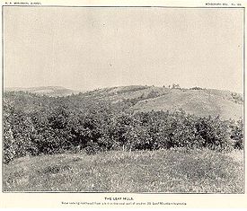
Leaf Hills Moraines
Encyclopedia
Minnesota
Minnesota is a U.S. state located in the Midwestern United States. The twelfth largest state of the U.S., it is the twenty-first most populous, with 5.3 million residents. Minnesota was carved out of the eastern half of the Minnesota Territory and admitted to the Union as the thirty-second state...
. The land, while not exhibiting many characteristics of mountains, nevertheless rises typically to a height of 100 feet (30 m) to 300 feet (91 m) above the surrounding farmland through the duration of its range, occasionally reaching higher than 350 feet (107 m). The name of this range of hills is translated from the Ojibwe Gaaskibag-wajiwan, which was interpreted by Gilfillan
Joseph Gilfillan
Joseph Alexander Gilfillan was an Episcopal missionary to Native Americans of the Ojibwa Tribe on White Earth Reservation in northern Minnesota during 35 years from 1873 until 1908.-Biography:...
as “Rustling Leaf Mountains.” The name is also shared by Leaf Mountain Township
Leaf Mountain Township, Minnesota
Leaf Mountain Township is a township in Otter Tail County, Minnesota, United States. The population was 309 at the 2000 census.-Geography:According to the United States Census Bureau, the township has a total area of , of which, of it is land and of it is water.-Demographics:As of the census of...
, the two Leaf Lakes ("Gaaskibag-wajiwi-zaaga'iganan"), and the Leaf River
Leaf River (Minnesota)
The Leaf River is a tributary of the Crow Wing River, about 50 mi long, in west-central Minnesota in the United States. Via the Crow Wing, it is part of the Mississippi River watershed.-Course:...
("Gaaskibag-wajiwi-ziibi"), all named for the hills. In turn, the hills in Ojibwe are named after Inspiration Peak
Inspiration Peak
Inspiration Peak is the highest peak of the Leaf Hills Moraines and of Otter Tail County in the U.S. State of Minnesota. It is 22 miles northwest of Alexandria. The peak rises about 400 feet above the surrounding plains, to an elevation of about 1750 feet above sea level...
("Gaaskibag-wajiw"), the highest hill of this hill range.
Description
The hills are described by UphamWarren Upham
Warren Upham was a geologist, archaeologist, and librarian who is best known for his studies of glacial Lake Agassiz. Upham worked as a geologist in New Hampshire before moving in 1879 to Minnesota to study the resources and glacial geology of that state...
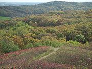
as "running southeast from Fergus Falls to the south line of the county and thence east and northeast to East Leaf Lake, a distance of 50 miles." Through their full extent in Otter Tail County, the hills have steeply sloped sides covered by prairies
Prairie
Prairies are considered part of the temperate grasslands, savannas, and shrublands biome by ecologists, based on similar temperate climates, moderate rainfall, and grasses, herbs, and shrubs, rather than trees, as the dominant vegetation type...
and deciduous
Deciduous
Deciduous means "falling off at maturity" or "tending to fall off", and is typically used in reference to trees or shrubs that lose their leaves seasonally, and to the shedding of other plant structures such as petals after flowering or fruit when ripe...
forests, primarily Maple
Maple
Acer is a genus of trees or shrubs commonly known as maple.Maples are variously classified in a family of their own, the Aceraceae, or together with the Hippocastanaceae included in the family Sapindaceae. Modern classifications, including the Angiosperm Phylogeny Group system, favour inclusion in...
and Oak
Oak
An oak is a tree or shrub in the genus Quercus , of which about 600 species exist. "Oak" may also appear in the names of species in related genera, notably Lithocarpus...
. In most regions these hills would not be considered mountains, but in generally flat Minnesota they are significant and unique features of the landscape, much more notable than in a really mountainous area.
Geology
The hills are formed by the convergence of the eighth and ninth marginal moraines formed by the Wadena and Des Moines lobes of the Wisconsonian glaciation. This moraine forms an arc about ten to twenty miles (16 -32 km) wide and 200 miles (320 km) long. It is composed of a huge volume of morainic drift up to 350 feet (107 m) thick, overlain with thin sandy soil as well as rocks and boulders.Landforms
Indian Hill (Minnesota)
Indian Hill, in section nine of Oscar Township, Otter Tail County, Minnesota, is a peak in the Leaf Mountains of west-central Minnesota. On its west side the hill provides a high vantage point over the upper valley of the Red River of the North, while to the east it provides a view of the adjacent...
and Inspiration Peak
Inspiration Peak
Inspiration Peak is the highest peak of the Leaf Hills Moraines and of Otter Tail County in the U.S. State of Minnesota. It is 22 miles northwest of Alexandria. The peak rises about 400 feet above the surrounding plains, to an elevation of about 1750 feet above sea level...
.
History
Paleoindians lived in the area at least 6,000 years ago, and perhaps longer, as earlier remains have been found in the general vicinity. Artifacts from both the Prairie and Woodland cultures have been found; most items date from a period starting 900 to 1200 years ago. In more recent times, the region was held by the Dakota until they were displaced by the OjibwaOjibwa
The Ojibwe or Chippewa are among the largest groups of Native Americans–First Nations north of Mexico. They are divided between Canada and the United States. In Canada, they are the third-largest population among First Nations, surpassed only by Cree and Inuit...
in the Eighteenth Century.
Also in the Eighteenth Century, the area became a source of pelts for the fur trade
Fur trade
The fur trade is a worldwide industry dealing in the acquisition and sale of animal fur. Since the establishment of world market for in the early modern period furs of boreal, polar and cold temperate mammalian animals have been the most valued...
. In the 1840s, the mountains were pierced by the Woods Trail and skirted by the East Plains Trail, two of the Red River Trails
Red River Trails
The Red River Trails were a network of ox cart routes connecting the Red River Colony and Fort Garry in British North America with the head of navigation on the Mississippi River in the United States...
between Fort Garry
Fort Garry
Fort Garry, also known as Upper Fort Garry, was a Hudson's Bay Company trading post at the confluence of the Red and Assiniboine rivers in what is now downtown Winnipeg. It was established in 1822 on or near the site of the North West Company's Fort Gibraltar. Fort Garry was named after Nicholas...
(modern Winnipeg
Winnipeg
Winnipeg is the capital and largest city of Manitoba, Canada, and is the primary municipality of the Winnipeg Capital Region, with more than half of Manitoba's population. It is located near the longitudinal centre of North America, at the confluence of the Red and Assiniboine Rivers .The name...
) and Saint Paul, Minnesota
Saint Paul, Minnesota
Saint Paul is the capital and second-most populous city of the U.S. state of Minnesota. The city lies mostly on the east bank of the Mississippi River in the area surrounding its point of confluence with the Minnesota River, and adjoins Minneapolis, the state's largest city...
. These trails opened up the area to settlement in the last half of the Nineteenth Century.
Due to their steepness and the abundance of fieldstone
Fieldstone
Fieldstone is a building construction material. Strictly speaking, it is stone collected from the surface of fields where it occurs naturally...
and boulders, the hills were found by pioneers to be generally unsuitable for plowing but well suited for raising and grazing livestock
Livestock
Livestock refers to one or more domesticated animals raised in an agricultural setting to produce commodities such as food, fiber and labor. The term "livestock" as used in this article does not include poultry or farmed fish; however the inclusion of these, especially poultry, within the meaning...
. Part of the region has been preserved in Maplewood State Park
Maplewood State Park
Maplewood State Park is a Minnesota state park near Pelican Rapids. The park preserves a pre-contact habitation site that was occupied in two different periods in a forest/prairie transition zone...
.