
Lawrence Hill, Bristol
Encyclopedia
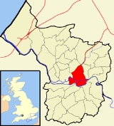
Lawrence Hill is an electoral ward of Bristol
, United Kingdom
. It takes its name from a small area just to the east of the city centre, and includes the districts of Barton Hill
, St Philips Marsh
and Redcliffe
, Temple Meads and parts of Easton
and the Broadmead
shopping area.
, is part of the Bristol European Union
Objective 2 area, and has a New Deal for Communities project within its boundaries. The Bristol & Bath Railway Path starts in the south of the ward.
Holy Trinity
was built between 1829 and 32 by Thomas Rickman
and Hutchinson. Later work in around 1882 was by John Bevan
and in 1905 by William Venn Gough
.

It includes residential, retail and industrial premises and is crossed by major roads, railway tracks and the feeder canal leading to Bristol Harbour.
The parish church is St Luke's, built 1843-50.
Christ Church Barton Hill was opened in 1883 and demolished in 1957. A large geometrical Gothic church without a west front but good looks and a nice apse
.
Redcliffe takes its name from the red sandstone cliffs which line the southern side of the Floating Harbour, behind Phoenix Wharf and Redcliffe Wharf. These cliffs are honey-combed with tunnels constructed both to extract sand for the local glass making industry and to act as store houses for goods. Part of the last remaining glass kiln in the area is now the Kiln Restaurant of the Hilton National Hotel in Redcliffe Way.[3][4]
The parish church of St. Mary Redcliffe is one of Bristol's best known churches, with a spire soaring to a height of 292ft (90m).
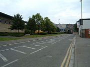
St Philips Marsh is an industrial inner suburb of Bristol. The River Avon and Harbour feeder canal run through the area. The site is currently home of a large retail and leisure park with Showcase cinemas and Hollywood Bowl among its residents. It has been extensively redeveloped in the past 15 years and a bypass runs over the River Avon creating a major transport link from the A4 road in south east Bristol, to junction 3 of the M32 motorway near the city centre. In past years St Philips marsh was a housing development for the workers of Bristol's market area (now known as Old Market). One of St Philips' more influential residents during the early 1900s was George Townsend, a major property developer of the South Bristol area. His family home situated in the St Anne's area of Bristol is still standing today and a reminder of bristols history.
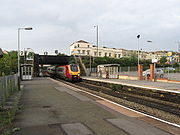 It is served by, Bristol Temple Meads railway station
and Lawrence Hill railway station
.
Bristol
Bristol is a city, unitary authority area and ceremonial county in South West England, with an estimated population of 433,100 for the unitary authority in 2009, and a surrounding Larger Urban Zone with an estimated 1,070,000 residents in 2007...
, United Kingdom
United Kingdom
The United Kingdom of Great Britain and Northern IrelandIn the United Kingdom and Dependencies, other languages have been officially recognised as legitimate autochthonous languages under the European Charter for Regional or Minority Languages...
. It takes its name from a small area just to the east of the city centre, and includes the districts of Barton Hill
Barton Hill, Bristol
Barton Hill is an area of Bristol, just to the east of the city centre and Bristol Temple Meads railway station.It includes residential, retail and industrial premises and is crossed by major roads, railway tracks and the feeder canal leading to Bristol Harbour.-History:Barton was a manor just...
, St Philips Marsh
St Philips Marsh
St Philip's Marsh is an industrial inner suburb of Bristol, England. It is bounded by River Avon and Harbour feeder canal making it an almost island area, unlike the other two areas surrounded by water, it was historically part of Gloucestershire...
and Redcliffe
Redcliffe, Bristol
Redcliffe, also known as Redcliff, is a district of the English port city of Bristol, adjoining the city centre. It is bounded by the loop of the Floating Harbour to the west, north and east, the New Cut of the River Avon to the south...
, Temple Meads and parts of Easton
Easton, Bristol
Easton is both the name of a council ward in the city of Bristol in the United Kingdom, and an inner city area that lies partly within that ward. The Easton ward also contains the Whitehall and Netham areas of the city. Notable places within the ward include Lawrence Hill and Stapleton Road railway...
and the Broadmead
Broadmead
Broadmead is a street in the central area of Bristol, England, which has given its name to the principal shopping district of the city.- History :The name of the street was first recorded in 1383 as Brodemede...
shopping area.
History
It is the most deprived electoral ward in the south west region of EnglandEngland
England is a country that is part of the United Kingdom. It shares land borders with Scotland to the north and Wales to the west; the Irish Sea is to the north west, the Celtic Sea to the south west, with the North Sea to the east and the English Channel to the south separating it from continental...
, is part of the Bristol European Union
European Union
The European Union is an economic and political union of 27 independent member states which are located primarily in Europe. The EU traces its origins from the European Coal and Steel Community and the European Economic Community , formed by six countries in 1958...
Objective 2 area, and has a New Deal for Communities project within its boundaries. The Bristol & Bath Railway Path starts in the south of the ward.
Holy Trinity
Holy Trinity Church, Lawrence Hill
The Trinity Centre, formerly the Holy Trinity Church, in Lawrence Hill, Bristol is designated by English Heritage as a grade II* listed building. The building is protected by a covenant, which states that it is to only be used for community, arts, youth and education services...
was built between 1829 and 32 by Thomas Rickman
Thomas Rickman
Thomas Rickman , was an English architect who was a major figure in the Gothic Revival.He was born at Maidenhead, Berkshire, into a large Quaker family, and avoided the medical career envisaged for him by his father, a grocer and druggist; he went into business for himself and married his first...
and Hutchinson. Later work in around 1882 was by John Bevan
John Bevan
John Bevan may refer to:* John Bevan , Welsh dual-code rugby international who played rugby union for Cardiff and rugby league for Warrington...
and in 1905 by William Venn Gough
William Venn Gough
William Venn Gough was an architect responsible for a number of prominent buildings in Bristol. His works include the Cabot Tower, Colston's Girls' School, Trinity Road Library, and Port of Bristol Authority Docks Office, now Queen Square House, in Queen Square.From 1872 he had an office at...
.
Barton Hill
Barton Hill is an area of Bristol, just to the east of the city centre and Bristol Temple Meads railway station.It includes residential, retail and industrial premises and is crossed by major roads, railway tracks and the feeder canal leading to Bristol Harbour.
The parish church is St Luke's, built 1843-50.
Christ Church Barton Hill was opened in 1883 and demolished in 1957. A large geometrical Gothic church without a west front but good looks and a nice apse
Apse
In architecture, the apse is a semicircular recess covered with a hemispherical vault or semi-dome...
.
Redcliffe
Redcliffe is a district adjoining the city centre. It is bounded by the loop of the Floating Harbour (including Bathurst Basin) to the west, north and east, the New Cut of the River Avon to the south and Temple Way and Temple Gate to the south-east. Most of Redcliffe lies within the city ward of Lawrence Hill, although the western most section, including the cliffs and hill from which the area takes its name, is in Cabot ward.[1][2]Redcliffe takes its name from the red sandstone cliffs which line the southern side of the Floating Harbour, behind Phoenix Wharf and Redcliffe Wharf. These cliffs are honey-combed with tunnels constructed both to extract sand for the local glass making industry and to act as store houses for goods. Part of the last remaining glass kiln in the area is now the Kiln Restaurant of the Hilton National Hotel in Redcliffe Way.[3][4]
The parish church of St. Mary Redcliffe is one of Bristol's best known churches, with a spire soaring to a height of 292ft (90m).
St Philips Marsh
St Philips Marsh is an industrial inner suburb of Bristol. The River Avon and Harbour feeder canal run through the area. The site is currently home of a large retail and leisure park with Showcase cinemas and Hollywood Bowl among its residents. It has been extensively redeveloped in the past 15 years and a bypass runs over the River Avon creating a major transport link from the A4 road in south east Bristol, to junction 3 of the M32 motorway near the city centre. In past years St Philips marsh was a housing development for the workers of Bristol's market area (now known as Old Market). One of St Philips' more influential residents during the early 1900s was George Townsend, a major property developer of the South Bristol area. His family home situated in the St Anne's area of Bristol is still standing today and a reminder of bristols history.
Transport
Bristol Temple Meads railway station
Bristol Temple Meads railway station is the oldest and largest railway station in Bristol, England. It is an important transport hub for public transport in Bristol, with bus services to various parts of the city and surrounding districts, and a ferry service to the city centre in addition to the...
and Lawrence Hill railway station
Lawrence Hill railway station
Lawrence Hill railway station serves the St. George area of Bristol, England as well as the surrounding suburbs of Easton, Barton Hill, Whitehall and Netham.The station is north of Bristol Temple Meads on the Severn Beach Line and is unmanned....
.