Raritan Bay is a
bayA bay is an area of water mostly surrounded by land. Bays generally have calmer waters than the surrounding sea, due to the surrounding land blocking some waves and often reducing winds. Bays also exist as an inlet in a lake or pond. A large bay may be called a gulf, a sea, a sound, or a bight...
located at the southern portion of
Lower New York Bay
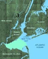
Lower New York Bay is that section of New York Bay south of the Narrows, the relatively narrow strait between the shores of Staten Island and Brooklyn. The southern end of the bay opens directly to the Atlantic Ocean between two spits of land, Sandy Hook, New Jersey, and Rockaway, Queens, on Long...
between the
U.S. stateA U.S. state is any one of the 50 federated states of the United States of America that share sovereignty with the federal government. Because of this shared sovereignty, an American is a citizen both of the federal entity and of his or her state of domicile. Four states use the official title of...
s of
New YorkNew York is a state in the Northeastern region of the United States. It is the nation's third most populous state. New York is bordered by New Jersey and Pennsylvania to the south, and by Connecticut, Massachusetts and Vermont to the east...
and
New JerseyNew Jersey is a state in the Northeastern and Middle Atlantic regions of the United States. , its population was 8,791,894. It is bordered on the north and east by the state of New York, on the southeast and south by the Atlantic Ocean, on the west by Pennsylvania and on the southwest by Delaware...
and is part of the
New York BightThe New York Bight is a slight indentation along the Atlantic coast of the United States, extending northeasterly from Cape May Inlet in New Jersey to Montauk Point on the eastern tip of Long Island...
. The bay is bounded on the northwest by New York's
Staten IslandStaten Island is a borough of New York City, New York, United States, located in the southwest part of the city. Staten Island is separated from New Jersey by the Arthur Kill and the Kill Van Kull, and from the rest of New York by New York Bay...
, on the west by
Perth Amboy, New JerseyPerth Amboy is a city in Middlesex County, New Jersey, United States. The City of Perth Amboy is part of the New York metropolitan area. As of the 2010 United States Census, the city population was 50,814. Perth Amboy is known as the "City by the Bay", referring to Raritan Bay.-Name:The Lenape...
, on the south by the
Raritan BayshoreThe Raritan Bayshore region of New Jersey is the area around Raritan Bay from The Amboys to Sandy Hook, mostly in Monmouth County, including the towns from Keyport, New Jersey, "Pearl of the Bayshore", to Highlands, New Jersey. At Keansburg is a traditional amusement park while at Sandy Hook are...
communities of
Monmouth County, New JerseyMonmouth County is a county located in the U.S. state of New Jersey, within the New York metropolitan area. As of the 2010 Census, the population was 630,380, up from 615,301 at the 2000 census. Its county seat is Freehold Borough. The most populous municipality is Middletown Township with...
, and on the east by Sandy Hook Bay. The bay is named after the Native American
RaritanRaritan was the name given to the Lenape Native American by Europeans who colonized the region around the Raritan River and its bay in northerneastern New Jersey and Staten Island, New York, in the seventeenth century....
s, a branch of the
LenapeThe Lenape are an Algonquian group of Native Americans of the Northeastern Woodlands. They are also called Delaware Indians. As a result of the American Revolutionary War and later Indian removals from the eastern United States, today the main groups live in Canada, where they are enrolled in the...
tribe who lived in the vicinity of the bay for thousands of years prior to the arrival of
DutchThe Netherlands is a constituent country of the Kingdom of the Netherlands, located mainly in North-West Europe and with several islands in the Caribbean. Mainland Netherlands borders the North Sea to the north and west, Belgium to the south, and Germany to the east, and shares maritime borders...
colonists in the 17th century.
History
Archeological evidence suggests that humans were already in the region at the close of the
PleistoceneThe Pleistocene is the epoch from 2,588,000 to 11,700 years BP that spans the world's recent period of repeated glaciations. The name pleistocene is derived from the Greek and ....
. The early "Big Game Hunters" vanished, but the coastal regions were resettled by peoples accustomed to village-style living ("tidewater communities") that subsisted on hunting and gathering marine shellfish, and eventually, on agriculture. In pre-Columbian times "woodlands cultures" probably centered in the Ohio Valley became the dominant cultural influence in the region. Large shell middens were found around Raritan Bay and on Staten Island, a testament of the utilization of the bay for food by Algonquin Indian tribes (Lenapes) who occupied the area when early Colonialists arrived. Unfortunately, early settlers used these shell piles for road construction and field fertilizer. Tottenville was once well known for its roads paved with oyster shells.
Geology
The
Raritan RiverThe Raritan River is a major river of central New Jersey in the United States. Its watershed drains much of the mountainous area of the central part of the state, emptying into the Raritan Bay on the Atlantic Ocean.-Description:...
was perhaps the major drainage channel along the ice front throughout the
Wisconsin glaciationThe last glacial period was the most recent glacial period within the current ice age occurring during the last years of the Pleistocene, from approximately 110,000 to 10,000 years ago....
(Stages 1, 2, 3 and 4). Prior to that time the region drained southward across the saddle between the
Atlantic HighlandsThe Navesink Highlands, sometimes referred to as the Highlands of Navesink and also known as the Atlantic Highlands, are a range of low hills and upland areas located along the United States Atlantic coast in New Jersey...
and the
Newark BasinThe Newark Basin is a sediment-filled rift basin located mainly in northern New Jersey but also stretching into south-eastern Pennsylvania and southern New York. It is part of the system of Eastern North America Rift Basins.-Geology:...
into the
Delaware RiverThe Delaware River is a major river on the Atlantic coast of the United States.A Dutch expedition led by Henry Hudson in 1609 first mapped the river. The river was christened the South River in the New Netherland colony that followed, in contrast to the North River, as the Hudson River was then...
Valley. This saddle area is a very broad flood plain that preserves river terrace gravels (Pensauken Formation) from the Sangemon Interglacial State (Stage 5), as well as older Pleistocene
fluvialFluvial is used in geography and Earth science to refer to the processes associated with rivers and streams and the deposits and landforms created by them...
deposits (The Bridgetown Formation). During the lowstand in sea level caused by the Wisconsin glacier, the Raritan River carved back into its headlands and captured the major drainages from the Newark Basin.
As the Wisconsin glaciers melted, the Flandrian Transgression eventually flooded the deeper valleys of the Hudson, Raritan, and Arthur Kill. During warming at the end of the Pleistocene and
Early HoloceneHolocene glacial retreat had a profound effect on landscapes in many areas that were covered by ice at the Last Glacial Maximum. The many valleys of the Cairngorms, a mountainous region in the Eastern Scottish Highlands are littered with deposits from this period.-Evidences of the retreat of the...
, the area encompassing Raritan Bay changed from tundra to a landscape dominated by spruce and pine forests. These forests gradually gave way to the modern deciduous forest in the region by mid-Holocene time. Lagoons and bays in the area around Sandy Hook hosted oysters, hard and soft shell clams, lobsters, blue crabs, and a variety of other invertebrates common in bays in the region today. South of western Long Island, tidal flats and wetlands occupied the margins of a tidal estuary (now submerged by marine waters). Inner Raritan Bay began to fill about 2,500 years ago with large oyster beds forming along the estuarine tributaries. Sea level continued to rise about one foot per century. This rise in sea level has resulted in the landward migration of the shoreline (aided by storm-induced coastal erosion) as much as two miles in some portions of the coast since colonial times.
Economy
The bay supported a lucrative fishing and
shellfishShellfish is a culinary and fisheries term for exoskeleton-bearing aquatic invertebrates used as food, including various species of molluscs, crustaceans, and echinoderms. Although most kinds of shellfish are harvested from saltwater environments, some kinds are found only in freshwater...
industry during the nineteenth and early twentieth centuries, especially oysters, which helped to support a stable population around the bay, and aided, in part, to feed the flood of immigration. Stable communities continued to grow and change with new industries supporting a larger population base. Advances in methods of fishing and shellfish collecting resulted in over-extraction of these resources from the bay. The peak of the fishing industry occurred in the late 1880s to 1910s.
Fishing and farming slowly gave way to industries including ship building, ceramics, chemicals and paint manufacturing, electrolytic copper refining, and petroleum refining. In the
Sayreville, New JerseySayreville is a borough located on the Raritan River, near Raritan Bay in Middlesex County, New Jersey, United States. As of the 2010 United States Census, the borough population was 42,704....
area large pits were dug to extract the clays for ceramics and bricks, and huge chemical dumps, fly ash piles, and landfills were created to accommodate the waste from the growing industrial empire. The building of shore management structures (dikes, groins, seawalls), the spraying of
DDTDDT is one of the most well-known synthetic insecticides. It is a chemical with a long, unique, and controversial history....
(and other
pesticidePesticides are substances or mixture of substances intended for preventing, destroying, repelling or mitigating any pest.A pesticide may be a chemical unicycle, biological agent , antimicrobial, disinfectant or device used against any pest...
s) to control the mosquito problem, the carving of ditches to drain wetlands, the filling of shore lowlands, the channelization of creeks, highway and sewer construction, neighborhood development, and a myriad point and non-point sources of household, automobile, industrial chemicals, and ocean dumping all contributed to growing toxicity of the bay.
For most of the twentieth century, the shores of Arthur Kill have been home to the largest petroleum importing, refining, and storage facilities on Earth; as a consequence the estuary has been host to major and minor oil spills. In addition, Arthur Kill drains the area encompassing the second largest landfill on Earth (Fresh Kills). This landfill, and others along the Raritan River, provide an ample supply of
leachateLeachate is any liquid that, in passing through matter, extracts solutes, suspended solids or any other component of the material through which it has passed....
to the waterways. Chemical wastes cause stress and disruption of the life cycles of plankton, shellfish and other invertebrates, and the fish, birds, and other wildlife they support. The result has been ecological disaster. The bay approached sterile conditions at the peak of pollution and algal bloom-induced anoxia. Environmental actions from the 1970s to present have helped slowly bring back sea life, but current conditions pale to the wealth of marine resources of the past; certain species of fish and birds continue to decline, and the introduction of tenacious exotic species from around the world contribute to their decline. As a sign of optimism though, oysters are beginning to naturally reappear in the Hudson River after having vanished completely about the time of
World War IIWorld War II, or the Second World War , was a global conflict lasting from 1939 to 1945, involving most of the world's nations—including all of the great powers—eventually forming two opposing military alliances: the Allies and the Axis...
.
Regional industrial overdevelopment and other pollution factors have raised
PCBPolychlorinated biphenyls are a class of organic compounds with 2 to 10 chlorine atoms attached to biphenyl, which is a molecule composed of two benzene rings. The chemical formula for PCBs is C12H10-xClx...
levels in the fish catch and prompted government recommendations against its routine consumption.
The bay is crossed by a dredged
channelIn physical geography, a channel is the physical confine of a river, slough or ocean strait consisting of a bed and banks.A channel is also the natural or human-made deeper course through a reef, sand bar, bay, or any shallow body of water...
allowing
commercial shipsShip transport is watercraft carrying people or goods . Sea transport has been the largest carrier of freight throughout recorded history. Although the importance of sea travel for passengers has decreased due to aviation, it is effective for short trips and pleasure cruises...
to enter the Arthur Kill.
Aquatic species
Some of Raritan Bay's fish include
striped bassThe striped bass is the state fish of Maryland, Rhode Island, South Carolina, and the state saltwater fish of New York, Virginia, and New Hampshire...
,
flukeThe Summer Flounder is a marine flatfish that is found in the Atlantic Ocean off the East coast of the United States and Canada. It is especially abundant in waters from North Carolina to Massachusetts.-Description:...
,
winter flounderThe winter flounder, Pseudopleuronectes americanus, is a right-eyed flatfish of the family Pleuronectidae. It is native to coastal waters of the western north Atlantic coast, from Labrador, Canada to Georgia, United States...
,
bluefishThe bluefish , called tailor in Australia, is a species of popular marine gamefish found in all climates. It is the sole species of the Pomatomidae family....
,
tautogThe tautog or blackfish also known as the "poor-man's lobster" , Tautoga onitis, is a fish of the wrasse family found in salt water from Nova Scotia to Georgia...
and
weakfishThe weakfish, Cynoscion regalis, is a marine fish of the drum family Sciaenidae.The head and back of this fish are dark brown in color with a greenish tinge. The sides have a faint silvery hue with dusky specks, and the belly is white. The origin of its name is based on the weakness of the mouth...
. The crustacean species represented include the blue crab,
fiddler crabA fiddler crab, sometimes known as a calling crab, may be any of approximately 100 species of semi-terrestrial marine crabs which make up the genus Uca. As members of the family Ocypodidae, fiddler crabs are most closely related to the ghost crabs of the genus Ocypode. This entire group is composed...
, green crab,
horseshoe crabThe Atlantic horseshoe crab, Limulus polyphemus, is a marine chelicerate arthropod. Despite its name, it is more closely related to spiders, ticks, and scorpions than to crabs. Horseshoe crabs are most commonly found in the Gulf of Mexico and along the northern Atlantic coast of North America...
and
spider crabLibinia emarginata, the portly spider crab, common spider crab or nine-spined spider crab, is a species of stenohaline crab that lives on the Atlantic coast of North America.-Distribution:...
.
ClamThe word "clam" can be applied to freshwater mussels, and other freshwater bivalves, as well as marine bivalves.In the United States, "clam" can be used in several different ways: one, as a general term covering all bivalve molluscs...
s and
musselThe common name mussel is used for members of several families of clams or bivalvia mollusca, from saltwater and freshwater habitats. These groups have in common a shell whose outline is elongated and asymmetrical compared with other edible clams, which are often more or less rounded or oval.The...
s also live in Raritan Bay. The bay is a popular destination for
recreational fishingRecreational fishing, also called sport fishing, is fishing for pleasure or competition. It can be contrasted with commercial fishing, which is fishing for profit, or subsistence fishing, which is fishing for survival....
due to its proximity to the densely populated areas of
Central JerseyCentral Jersey is a common designation for a region of the state of New Jersey in the United States of America. Trenton is considered the boundary between designated "North Jersey" and "South Jersey"...
and
New York CityNew York is the most populous city in the United States and the center of the New York Metropolitan Area, one of the most populous metropolitan areas in the world. New York exerts a significant impact upon global commerce, finance, media, art, fashion, research, technology, education, and...
.
See also
- Geography of New York-New Jersey Harbor Estuary
- Marine life of New York-New Jersey Harbor Estuary
External links