
Lambton County, Ontario
Encyclopedia
Lambton County is a census division
of the Canadian province of Ontario
. The county
is located in Southwestern Ontario
. It is bordered on the north by Lake Huron
, which flows into the St. Clair River
, the county's western border and part of the Canada
-United States
border. To the south is Lake Saint Clair
and Chatham-Kent
, another county in Ontario. Lambton County's eastern border follows the Ausable River north until it reaches Lake Huron
at the beach community of Grand Bend
. The county seat is in the Town of Plympton-Wyoming. Lambton County started as a part of the District of Hesse
. The district of Hesse included British territories west of Long Point, (practically all of western Ontario). The district was latter divided and renamed using English district names (Essex, Suffolk, Kent, etc.). Lambton was part of Kent county. In 1849 districts were abolished and the County of Lambton was formed. Lambton and Kent first shared the capital city of Sandwich (since renamed as Windsor, Ontario
). In 1852 the partnership was dissolved and Lambton become a full county. It is named in honour of the Earl of Durham
who lived in Lambton Castle
. (Source: London Free Press, July 15, 1939, by W.G. Trestain)
The largest city in Lambton County is Sarnia
, which is located at the mouth of the St. Clair River. The two Blue Water Bridge
s cross the river at Sarnia, connecting it to Port Huron, Michigan
. The bridges are one of the busiest border crossings between the two countries. The river is also traversed by two passenger ferries further south, and a rail tunnel, also at Sarnia, runs underneath it. The CN rail tunnel accommodates double stacked rail cars.
Total employment for Lambton County (including the City of Sarnia) is 66,370. Of those 9,760 (14.7%) are employed in manufacturing; 7,545 (11.4%) in retail trade; 5,080 (7.7%) in accommodation and food services; and 3,155 (4.8%) are employed in agriculture.
Petrochemical and refining is the largest manufacturing sector in Lambton County's economy. Established during World War II
, Sarnia and the area along the St. Clair River is home to a major processing centre for oil from Alberta
.
In late 2010 and early 2011 a number of companies announced plans to provide ethane from the Marcellus Shale in the USA to Lambton County industries; providing a potential new feedstock for the production of ethylene in Lambton County.
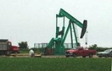
Lambton County is the site of North America's first drilled commercial oil well at Oil Springs, Ontario
in 1858. Tourism is another important industry in Lambton County, especially along the lake and river. The community of Grand Bend, and the Pinery Provincial Park
are especially popular tourist destinations, attracting thousands of people each week throughout the summer to their long, uninterrupted beaches. The part of Lambton County along Lake Huron known as Lambton Shores
depends almost entirely upon the seasonal industries of tourism and agriculture for its well-being. There are also popular conservation areas along the St. Clair River, and a conservation area named Rock Glen Falls near Arkona along the Ausauble River internationally known for its Devonian Era fossils.
Lambton County has 2,346 farms with a total of 592,793 acres. The largest single use of farmland in Lambton is crop production,with 85% of total farmland reported as land in crops. Over the last 20 years soybeans, wheat, and grain corn have accounted for over 80% of total area crop production in Lambton. The fourth and fifth leading crops are sugar beets and hay. Among other crops oats, barley and mixed grains are also produced. Top animal production includes dairy, beef, hog, and poultry. . .

is located in the shadows of many of the refineries in Sarnia's Chemical Valley. Walpole Island
also has a First Nation community, near Wallaceburg.
Census division
Census division is an official term in Canada and the United States. The census divisions of Canada are second-level census geographic unit, below provinces and territories, and above "census subdivisions" and "dissemination areas". In provinces where they exist, the census division may correspond...
of the Canadian province of Ontario
Ontario
Ontario is a province of Canada, located in east-central Canada. It is Canada's most populous province and second largest in total area. It is home to the nation's most populous city, Toronto, and the nation's capital, Ottawa....
. The county
County
A county is a jurisdiction of local government in certain modern nations. Historically in mainland Europe, the original French term, comté, and its equivalents in other languages denoted a jurisdiction under the sovereignty of a count A county is a jurisdiction of local government in certain...
is located in Southwestern Ontario
Southwestern Ontario
Southwestern Ontario is a subregion of Southern Ontario in the Canadian province of Ontario, centred on the city of London. It extends north to south from the Bruce Peninsula on Lake Huron to the Lake Erie shoreline, and east to south-west roughly from Guelph to Windsor. The region had a population...
. It is bordered on the north by Lake Huron
Lake Huron
Lake Huron is one of the five Great Lakes of North America. Hydrologically, it comprises the larger portion of Lake Michigan-Huron. It is bounded on the east by the Canadian province of Ontario and on the west by the state of Michigan in the United States...
, which flows into the St. Clair River
St. Clair River
The St. Clair River is a river in central North America which drains Lake Huron into Lake St Clair, forming part of the international boundary between the Canadian province of Ontario and the U.S. state of Michigan...
, the county's western border and part of the Canada
Canada
Canada is a North American country consisting of ten provinces and three territories. Located in the northern part of the continent, it extends from the Atlantic Ocean in the east to the Pacific Ocean in the west, and northward into the Arctic Ocean...
-United States
United States
The United States of America is a federal constitutional republic comprising fifty states and a federal district...
border. To the south is Lake Saint Clair
Lake Saint Clair (North America)
Lake St. Clair is a fresh-water lake named after Clare of Assisi that lies between the Province of Ontario and the State of Michigan, and its midline also forms the boundary between Canada and the United States of America. Lake St. Clair includes the Anchor Bay along the Metro Detroit coastline...
and Chatham-Kent
Chatham-Kent, Ontario
Chatham–Kent is a unitary authority in Southwestern Ontario, Canada. Mostly rural, its centres of population are Blenheim, Chatham, Dresden, Ridgetown, Tilbury and Wallaceburg. Modern Chatham–Kent was created in 1998 by the merger of Kent County and its municipalities.- History :The former city of...
, another county in Ontario. Lambton County's eastern border follows the Ausable River north until it reaches Lake Huron
Lake Huron
Lake Huron is one of the five Great Lakes of North America. Hydrologically, it comprises the larger portion of Lake Michigan-Huron. It is bounded on the east by the Canadian province of Ontario and on the west by the state of Michigan in the United States...
at the beach community of Grand Bend
Grand Bend, Ontario
Grand Bend, often referred to as simply "The Bend" or "GB," is a Southern Ontario community located on the shores of Lake Huron and a part of the municipality of Lambton Shores in the county of Lambton.Grand Bend is home to a variety of stores and eateries...
. The county seat is in the Town of Plympton-Wyoming. Lambton County started as a part of the District of Hesse
Western District, Upper Canada
Western District was one of four districts of the Province of Quebec created in 1788 in the western reaches of the Montreal District and partitioned in 1791 to create the new colony of Upper Canada. Known as Hesse District until 1792, it was abolished in 1849...
. The district of Hesse included British territories west of Long Point, (practically all of western Ontario). The district was latter divided and renamed using English district names (Essex, Suffolk, Kent, etc.). Lambton was part of Kent county. In 1849 districts were abolished and the County of Lambton was formed. Lambton and Kent first shared the capital city of Sandwich (since renamed as Windsor, Ontario
Windsor, Ontario
Windsor is the southernmost city in Canada and is located in Southwestern Ontario at the western end of the heavily populated Quebec City – Windsor Corridor. It is within Essex County, Ontario, although administratively separated from the county government. Separated by the Detroit River, Windsor...
). In 1852 the partnership was dissolved and Lambton become a full county. It is named in honour of the Earl of Durham
John Lambton, 1st Earl of Durham
John George Lambton, 1st Earl of Durham GCB, PC , also known as "Radical Jack" and commonly referred to in history texts simply as Lord Durham, was a British Whig statesman, colonial administrator, Governor General and high commissioner of British North America...
who lived in Lambton Castle
Lambton Castle
Lambton Castle, located in County Durham, England, between the towns of Washington and Chester-le-Street, is a stately home, the ancestral seat of the Lambton family, the Earls of Durham...
. (Source: London Free Press, July 15, 1939, by W.G. Trestain)
The largest city in Lambton County is Sarnia
Sarnia, Ontario
Sarnia is a city in Southern Ontario, Canada . It is the largest city on Lake Huron and is located where the upper Great Lakes empty into the St. Clair River....
, which is located at the mouth of the St. Clair River. The two Blue Water Bridge
Blue Water Bridge
The Blue Water Bridge is a twin-span international bridge across the St. Clair River that links Port Huron, Michigan, USA and Sarnia, Ontario, Canada...
s cross the river at Sarnia, connecting it to Port Huron, Michigan
Port Huron, Michigan
Port Huron is a city in the U.S. state of Michigan and the county seat of St. Clair County. The population was 30,184 at the 2010 census. The city is adjacent to Port Huron Township but is administratively autonomous. It is joined by the Blue Water Bridge over the St. Clair River to Sarnia,...
. The bridges are one of the busiest border crossings between the two countries. The river is also traversed by two passenger ferries further south, and a rail tunnel, also at Sarnia, runs underneath it. The CN rail tunnel accommodates double stacked rail cars.
Total employment for Lambton County (including the City of Sarnia) is 66,370. Of those 9,760 (14.7%) are employed in manufacturing; 7,545 (11.4%) in retail trade; 5,080 (7.7%) in accommodation and food services; and 3,155 (4.8%) are employed in agriculture.
Petrochemical and refining is the largest manufacturing sector in Lambton County's economy. Established during World War II
World War II
World War II, or the Second World War , was a global conflict lasting from 1939 to 1945, involving most of the world's nations—including all of the great powers—eventually forming two opposing military alliances: the Allies and the Axis...
, Sarnia and the area along the St. Clair River is home to a major processing centre for oil from Alberta
Alberta
Alberta is a province of Canada. It had an estimated population of 3.7 million in 2010 making it the most populous of Canada's three prairie provinces...
.
In late 2010 and early 2011 a number of companies announced plans to provide ethane from the Marcellus Shale in the USA to Lambton County industries; providing a potential new feedstock for the production of ethylene in Lambton County.
Lambton County is the site of North America's first drilled commercial oil well at Oil Springs, Ontario
Oil Springs, Ontario
Oil Springs is a village in Lambton County, Ontario, Canada, located along Former Provincial Highway 21 south of Oil City. The village, an enclave within Enniskillen Township, is home to the Oil Museum of Canada....
in 1858.
Pinery Provincial Park
The Pinery Provincial Park is a park located on Lake Huron near Grand Bend, Ontario. It occupies an area of 25.32 square kilometres ....
are especially popular tourist destinations, attracting thousands of people each week throughout the summer to their long, uninterrupted beaches. The part of Lambton County along Lake Huron known as Lambton Shores
Lambton Shores, Ontario
Lambton Shores is a municipality with city status in the County of Lambton in Ontario, Canada, that is on the southern shores of Lake Huron. It was formed in 2001 when the Towns of Bosanquet and Forest, and the Villages of Thedford, Arkona, and Grand Bend were amalgamated.-Weather:Lambton Shores is...
depends almost entirely upon the seasonal industries of tourism and agriculture for its well-being. There are also popular conservation areas along the St. Clair River, and a conservation area named Rock Glen Falls near Arkona along the Ausauble River internationally known for its Devonian Era fossils.
Lambton County has 2,346 farms with a total of 592,793 acres. The largest single use of farmland in Lambton is crop production,with 85% of total farmland reported as land in crops. Over the last 20 years soybeans, wheat, and grain corn have accounted for over 80% of total area crop production in Lambton. The fourth and fifth leading crops are sugar beets and hay. Among other crops oats, barley and mixed grains are also produced. Top animal production includes dairy, beef, hog, and poultry. . .
Highways
 Ontario Highway 402 ends in Sarnia, OntarioSarnia, OntarioSarnia is a city in Southern Ontario, Canada . It is the largest city on Lake Huron and is located where the upper Great Lakes empty into the St. Clair River....
at the Blue Water BridgeBlue Water BridgeThe Blue Water Bridge is a twin-span international bridge across the St. Clair River that links Port Huron, Michigan, USA and Sarnia, Ontario, Canada...
, where it meets at the U.S. border and connects with I-69Interstate 69Interstate 69 is an Interstate Highway in the United States. It exists in two parts: a completed highway from Indianapolis, Indiana, northeast to the Canadian border in Port Huron, Michigan, and a mostly proposed extension southwest to the Mexican border in Texas...
and I-94Interstate 94Interstate 94 is the northernmost east–west Interstate Highway, connecting the Great Lakes and Intermountain regions of the United States. I-94's western terminus is in Billings, Montana at a junction with Interstate 90; its eastern terminus is the U.S...
.
Cities and Towns
- City of SarniaSarnia, OntarioSarnia is a city in Southern Ontario, Canada . It is the largest city on Lake Huron and is located where the upper Great Lakes empty into the St. Clair River....
- Municipality (city) of Lambton ShoresLambton Shores, OntarioLambton Shores is a municipality with city status in the County of Lambton in Ontario, Canada, that is on the southern shores of Lake Huron. It was formed in 2001 when the Towns of Bosanquet and Forest, and the Villages of Thedford, Arkona, and Grand Bend were amalgamated.-Weather:Lambton Shores is...
- Town of PetroliaPetrolia, OntarioPetrolia is a town in Ontario, Canada, near Sarnia. The town, an enclave within Enniskillen Township, is billed as "Canada's Victorian Oil Town" and is often credited with starting the Oil industry in North America....
- Town of Plympton-WyomingPlympton-Wyoming, OntarioPlympton-Wyoming is a town in the Canadian province of Ontario, located in Lambton County immediately east of Sarnia. It is the seat of the Lambton County Council....
Townships and Villages
- Township of Brooke-AlvinstonBrooke-Alvinston, OntarioBrooke-Alvinston is a township in the Canadian province of Ontario, located within Lambton County. It was formed on January 1, 2001, when the Township of Brooke was amalgamated with the Village of Alvinston ....
- Township of Dawn-EuphemiaDawn-Euphemia, OntarioDawn-Euphemia is a township in southwestern Ontario, Canada, in Lambton County. Residents primarily are employed by the agricultural industry, or by local industries such as Union Gas distribution center, along with various smaller agricultural manufacturers or service providers...
- Township of EnniskillenEnniskillen, OntarioTownship of Enniskillen is a township in the Canadian province of Ontario, located within Lambton County. It is located at the intersection of Highway 21 and Rokeby Line....
- Township of St. ClairSt. Clair, OntarioSt. Clair is a township in southwestern Ontario, Canada, immediately south of Sarnia in Lambton County, along the eastern shores of the St. Clair River.- Communities :...
- Township of WarwickWarwick, OntarioWarwick is a rural township in Lambton County, Ontario, Canada, with a population of 4,025.Bisected by the Egremont Road that was surveyed to link London with the Lake Huron shoreline in 1832, the township began to attract settlers including those helped by charitable organizations, such as Lord...
- Village of Oil SpringsOil Springs, OntarioOil Springs is a village in Lambton County, Ontario, Canada, located along Former Provincial Highway 21 south of Oil City. The village, an enclave within Enniskillen Township, is home to the Oil Museum of Canada....
- Village of Point EdwardPoint Edward, OntarioPoint Edward is a village in the Canadian province of Ontario. Adjacent to the city of Sarnia in Lambton County, Point Edward sits opposite Port Huron, Michigan at the mouth of the St. Clair River...
Ojibwe and First Nation Communities
The Chippewas of Kettle and Stony Point First Nation occupy the Kettle Point area, separate from the surrounding municipality of Lambton Shores but included in the county. The Aamjiwnaang First NationAamjiwnaang First Nation
The Aamjiwnaang First Nation is a First Nations community of about 850 Chippewa Aboriginal peoples. They live on the Sarnia 45 Indian Reserve, located on the shores of the St...
is located in the shadows of many of the refineries in Sarnia's Chemical Valley. Walpole Island
Walpole Island
Walpole Island is an island and Indian reserve in southwestern Ontario, Canada, on the border between Ontario and Michigan in the United States. It is located in the mouth of the St. Clair River on Lake St. Clair, approximately thirty miles northeast of Detroit, Michigan, and Windsor, Ontario.In...
also has a First Nation community, near Wallaceburg.
Communities
- Alvinston
- ArkonaArkona, OntarioArkona is a community located in the municipality of Lambton Shores in southwestern Ontario near the Lambton-Middlesex county line, situated beside the Ausable River, on Former Kings Highway 79 , Arkona is roughly half-way between Thedford, and Watford...
- BrigdenBrigden, OntarioBrigden is a community in the township of St. Clair, Lambton County, Ontario, Canada. The community is located at the crossroads of Courtright Line and Brigden Road, between Kimball to the west and Oil City to the east, and about southeast of the city of Sarnia...
- Brights GroveBrights Grove, OntarioBrights Grove is a bedroom community in Sarnia, Lambton County, Ontario, Canada,on the shore of Lake Huron. It is the childhood home of golf pro Mike Weir, winner of the 2003 Masters.- The Owenite Project :...
- Corunna
- Courtright
- ForestForest, Lambton County, OntarioForest is a small town located near Sarnia, Ontario in Canada. It is very close to the shore of Lake Huron and is part of the municipality of Lambton Shores and the county of Lambton.- Population :...
- Grand BendGrand Bend, OntarioGrand Bend, often referred to as simply "The Bend" or "GB," is a Southern Ontario community located on the shores of Lake Huron and a part of the municipality of Lambton Shores in the county of Lambton.Grand Bend is home to a variety of stores and eateries...
- PetroliaPetrolia, OntarioPetrolia is a town in Ontario, Canada, near Sarnia. The town, an enclave within Enniskillen Township, is billed as "Canada's Victorian Oil Town" and is often credited with starting the Oil industry in North America....
- Port FranksPort Franks, OntarioPort Franks is a small Southern Ontario community in the municipality of Lambton Shores, Lambton County in southwestern Ontario, Canada. It is located along Kings Highway 21 near Pinery Provincial Park, about north of Thedford, Ontario...
- Port LambtonPort Lambton, OntarioPort Lambton is a village situated on the St. Clair River, in southwestern Ontario, Canada within the municipality of St. Clair Township. According to the latest census, 1084 people live within this Lambton County, Ontario community...
- SarniaSarnia, OntarioSarnia is a city in Southern Ontario, Canada . It is the largest city on Lake Huron and is located where the upper Great Lakes empty into the St. Clair River....
- Sombra
- ThedfordThedford, OntarioThedford is a small community in northwestern Lambton County, Ontario Canada, situated 8 km south of Kings Highway 21, along Lambton CR 79 . The community began in the 1860's when farmer Nelson Southworth, a native of Vermont, agreed to donate land for the construction of a Grand Trunk Railway...
- Walpole IslandWalpole IslandWalpole Island is an island and Indian reserve in southwestern Ontario, Canada, on the border between Ontario and Michigan in the United States. It is located in the mouth of the St. Clair River on Lake St. Clair, approximately thirty miles northeast of Detroit, Michigan, and Windsor, Ontario.In...
- Watford
- Wyoming
Adjacent counties and municipalities
- Huron CountyHuron County, OntarioHuron County is a census division and county of the province of Ontario, Canada. It is located on the southeast shore of its namesake, Lake Huron, in the southwest part of the province...
(northeast) - Middlesex CountyMiddlesex County, OntarioMiddlesex County is a primarily rural county in Southwestern Ontario. Landlocked, the county is bordered by Huron and Perth counties on the north, Oxford County on the east, Elgin County on the south, and Chatham-Kent and Lambton County on the west.The seat is the city of London, although the city...
(east) - Chatham-Kent (south)
- St. Clair CountySt. Clair County, Michigan-Interstates:* I-69 enters the county from the west, coming from Lansing and Flint, terminating at the approach to the Blue Water Bridge in Port Huron....
, MichiganMichiganMichigan is a U.S. state located in the Great Lakes Region of the United States of America. The name Michigan is the French form of the Ojibwa word mishigamaa, meaning "large water" or "large lake"....
, USUnited StatesThe United States of America is a federal constitutional republic comprising fifty states and a federal district...
(west)
External links
- Grand Bend Strip community newspaper - serving north Lambton County (Grand Bend and Port Franks).
- Visit Grand Bend - North Lambton Visitor Guide
- Ontario Visual Heritage Project: Sarnia-Lambton
- Historic bridges in Lambton County
- Lambton County - The Corporation of the County of Lambton.
- Lambton County History.
- The Lambton Shield | Sarnia-Lambton Online News.