

St. Clair, Ontario
Encyclopedia
St. Clair is a township
in southwestern Ontario
, Canada
, immediately south of Sarnia
in Lambton County
, along the eastern shores of the St. Clair River
.
, Charlemont, Colinville, Courtright, Corunna, Cromar, Duthill, Frog Point, Froomfield, Kimball, Ladysmith, Moore Centre, Mooretown, Osborne, Payne, Port Lambton
, Port Seckerton, Sombra, Sykeston, Thornyhurst, Vye's Grove
, Waubuno, West Becher, Wilkesport.
in Spain
. He chose to name the site after the town La Coruña in Spain because he had spent considerable time there during the Napoleonic Wars
. The town's name also owes itself to one of Beresford's commanders, Sir John Moore, who died at the hands of French forces in the Battle of Corunna. Beresford had been sent on a mission to find a suitable capital for a future union between the colonies of Upper Canada
(Ontario) and Lower Canada
(Quebec). Corunna was not chosen, as it was seen as being too close to the American
border — in the 1820s-1830s, the prospect of an Irish Fenian raid
from the United States was considered a serious threat to the British colonies. Today, a small stone cairn
stands along Baird Street, near the CSX north-south train track that divides the town. The cairn marks the spot where survey crews planned to build St. George's Square, the area that was to house the Parliament Buildings.
Today, most of Corunna's streets in the downtown bear the name of British military officials that served with Lord Beresford. The streets (Beckwith, Beresford, Baird, Fane, Paget, Lyndoch, Cameron, Bentinck, Colborne, Hill, Murray, etc.) follow some of the original specifications that Beresford's survey crew set out as part of its plans to create a capital.
The Corunna area was originally settled by French farmers, who rented land near the river from the Chippewa First Nation. As the French presence faded, Corunna was settled by a wave of British settlers. One early settler was James Cruickshank, who settled south of Corunna on the Eighth Line near Kimball Side Road, in 1834. A plaque to commemorate his early contribution to the township can be seen in the village of Corunna in a park on Beresford Street, on land which was donated by the descendants of James. The town saw an influx of gristmills, saw mills and taverns. There were attempts to build a canal through Corunna early in its history, but the canal was abandoned soon after it was dug, since it could not maintain consistent water levels. The early history of the town is spotty, but some accounts suggest a brewery was briefly in business in the town. In the 1920's and 30's, there were some village stores. A popular general store, owned by Catland and Alison, called Vag Lickins, was on the west side of Lyndock, north of Hill, where an Esso station later stood and now is a dentist office. Billy Locke, brother of Jack, ran Billy's Bunnery. Billy Garoch had another general store on the Lyndoch and Hill corner where the liquor store is now. It later became MacRae's store and closed in the early 1960's. Billy Garoch also had an ice house to the east of his store, in the old school that had been moved from Lyndoch near the present Roses Variety Store.
Many of Corunna's historic relics have been torn down over the years, but a few structures remain, providing clues to the area's history. The town's Catholic church, St. Joseph's, was built in 1862 and still stands. Its wooden structure is bolstered by enormous trunks of the area's original trees, which were simply squared off and put in place to build the church. Several 1800s vintage homes remain in the town as well. Ambers statue is still standing located near the water on St.Clair parkway.
 Baby's Point is the extreme southern point of Lambton County. Kayla Baby owned all the land from this point, and all of Port Lambton site. Inherited from his Grandfather in 1742. There also was a brother, James Baby. Edward Kelly was the first postmaster at Baby's Point 1848.
After 1812, people started to settle along the St. Clair River. They were French, and didn't have legal title to the land. When the Irish moved in, the French sold their squatters rights to the Irish about 1833. The Indians could sell land only with the approval of the Province. Anyhow, soon after 1812, people bought up land legally along the St. Clair River. In the spring of 1820, Duncan McDonald built the first frame house. A post office opened in 1871, one time known as Lambton Village. Rural mail was first delivered in 1908, and all mail routes completed in January 1909.
The first Sacred Heart Church was built at Baby's Butt Point around 1825. It burned. Fr. Monocq was drowned January 12, 1861, and the body was found in 1862. He was buried beneath the altar of the first Port Lambton Church. The plaque was on the right hand of the side altar. The Sacred Heart Church, Port Lambton, was built in 1877. Martin Regan was the first person baptised there, December 1877. It was demolished, and the new church built on the same site in 1964.
Brigden houses Brigden Public School, Corunna hosts of three schools - two public schools (Sir John Moore, opened in 2000 and Colonel Cameron) and one Catholic school (St. Joseph's), the latter of which opened in September of 1992. Colborne Street School was a public school on Colborne Street, that closed in 2000. Murray Street School (K. to 5) on Murray Street was closed earlier. Hill Street School (originally a Jr. room and Sr. room, a teacher's room and principal's office, then later a Gr.6-8 school), the earliest school still standing in Corunna, located at the corner of Hill and Lyndock, was closed several years ago as well, and is now an O.P.P station. Students who attended Colborne, transferred to Colonel Cameron or Sir John Moore. The building currently housing Colonel Cameron was previously Father Gerald LaBelle Catholic School, which was open between 1976 and the early 2000s.
Corunna has not developed any high schools, though the topic has been debated in the past.
Port Lambton
is home to two schools - Riverview Central School and Sacred Heart Catholic Elementary School.
Mooretown has a school named Mooretown Courtright Public School.
has given St. Clair Township a reputation for its beautiful parks along the riverfront. The head office had been located in Corunna since 1968. As of February 2006, the St. Clair Parkway has been disbanded and the parks have been handed over to the municipalities where they are located.
Township (Canada)
The term township generally means the district or area associated with a town. However in some systems no town needs to be involved. The specific use of the term to describe political subdivisions has varied by country, usually to describe a local rural or semi-rural government within the county...
in southwestern Ontario
Ontario
Ontario is a province of Canada, located in east-central Canada. It is Canada's most populous province and second largest in total area. It is home to the nation's most populous city, Toronto, and the nation's capital, Ottawa....
, Canada
Canada
Canada is a North American country consisting of ten provinces and three territories. Located in the northern part of the continent, it extends from the Atlantic Ocean in the east to the Pacific Ocean in the west, and northward into the Arctic Ocean...
, immediately south of Sarnia
Sarnia, Ontario
Sarnia is a city in Southern Ontario, Canada . It is the largest city on Lake Huron and is located where the upper Great Lakes empty into the St. Clair River....
in Lambton County
Lambton County, Ontario
Lambton County is a census division of the Canadian province of Ontario. The county is located in Southwestern Ontario. It is bordered on the north by Lake Huron, which flows into the St. Clair River, the county's western border and part of the Canada-United States border. To the south is Lake...
, along the eastern shores of the St. Clair River
St. Clair River
The St. Clair River is a river in central North America which drains Lake Huron into Lake St Clair, forming part of the international boundary between the Canadian province of Ontario and the U.S. state of Michigan...
.
Communities
The township comprises the communities of Avonry, Babys Point, Becher, Bickford, Bradshaw, BrigdenBrigden, Ontario
Brigden is a community in the township of St. Clair, Lambton County, Ontario, Canada. The community is located at the crossroads of Courtright Line and Brigden Road, between Kimball to the west and Oil City to the east, and about southeast of the city of Sarnia...
, Charlemont, Colinville, Courtright, Corunna, Cromar, Duthill, Frog Point, Froomfield, Kimball, Ladysmith, Moore Centre, Mooretown, Osborne, Payne, Port Lambton
Port Lambton, Ontario
Port Lambton is a village situated on the St. Clair River, in southwestern Ontario, Canada within the municipality of St. Clair Township. According to the latest census, 1084 people live within this Lambton County, Ontario community...
, Port Seckerton, Sombra, Sykeston, Thornyhurst, Vye's Grove
Vye's Grove, Ontario
Vye's Grove was the homestead of the Vye family, pioneer settlers of Lambton County, Ontario, Canada. It was the site of an annual picnic sponsored by the United Farmers of Ontario....
, Waubuno, West Becher, Wilkesport.
History
In 1823, Lord Hicks surveyed the town site of Corunna, naming it after the Battle of CorunnaBattle of Corunna
The Battle of Corunna refers to a battle of the Peninsular War. On January 16, 1809, a French army under Marshal Soult attacked the British under Sir John Moore...
in Spain
Spain
Spain , officially the Kingdom of Spain languages]] under the European Charter for Regional or Minority Languages. In each of these, Spain's official name is as follows:;;;;;;), is a country and member state of the European Union located in southwestern Europe on the Iberian Peninsula...
. He chose to name the site after the town La Coruña in Spain because he had spent considerable time there during the Napoleonic Wars
Napoleonic Wars
The Napoleonic Wars were a series of wars declared against Napoleon's French Empire by opposing coalitions that ran from 1803 to 1815. As a continuation of the wars sparked by the French Revolution of 1789, they revolutionised European armies and played out on an unprecedented scale, mainly due to...
. The town's name also owes itself to one of Beresford's commanders, Sir John Moore, who died at the hands of French forces in the Battle of Corunna. Beresford had been sent on a mission to find a suitable capital for a future union between the colonies of Upper Canada
Upper Canada
The Province of Upper Canada was a political division in British Canada established in 1791 by the British Empire to govern the central third of the lands in British North America and to accommodate Loyalist refugees from the United States of America after the American Revolution...
(Ontario) and Lower Canada
Lower Canada
The Province of Lower Canada was a British colony on the lower Saint Lawrence River and the shores of the Gulf of Saint Lawrence...
(Quebec). Corunna was not chosen, as it was seen as being too close to the American
United States
The United States of America is a federal constitutional republic comprising fifty states and a federal district...
border — in the 1820s-1830s, the prospect of an Irish Fenian raid
Fenian raids
Between 1866 and 1871, the Fenian raids of the Fenian Brotherhood who were based in the United States; on British army forts, customs posts and other targets in Canada, were fought to bring pressure on Britain to withdraw from Ireland. They divided many Catholic Irish-Canadians, many of whom were...
from the United States was considered a serious threat to the British colonies. Today, a small stone cairn
Cairn
Cairn is a term used mainly in the English-speaking world for a man-made pile of stones. It comes from the or . Cairns are found all over the world in uplands, on moorland, on mountaintops, near waterways and on sea cliffs, and also in barren desert and tundra areas...
stands along Baird Street, near the CSX north-south train track that divides the town. The cairn marks the spot where survey crews planned to build St. George's Square, the area that was to house the Parliament Buildings.
Today, most of Corunna's streets in the downtown bear the name of British military officials that served with Lord Beresford. The streets (Beckwith, Beresford, Baird, Fane, Paget, Lyndoch, Cameron, Bentinck, Colborne, Hill, Murray, etc.) follow some of the original specifications that Beresford's survey crew set out as part of its plans to create a capital.
The Corunna area was originally settled by French farmers, who rented land near the river from the Chippewa First Nation. As the French presence faded, Corunna was settled by a wave of British settlers. One early settler was James Cruickshank, who settled south of Corunna on the Eighth Line near Kimball Side Road, in 1834. A plaque to commemorate his early contribution to the township can be seen in the village of Corunna in a park on Beresford Street, on land which was donated by the descendants of James. The town saw an influx of gristmills, saw mills and taverns. There were attempts to build a canal through Corunna early in its history, but the canal was abandoned soon after it was dug, since it could not maintain consistent water levels. The early history of the town is spotty, but some accounts suggest a brewery was briefly in business in the town. In the 1920's and 30's, there were some village stores. A popular general store, owned by Catland and Alison, called Vag Lickins, was on the west side of Lyndock, north of Hill, where an Esso station later stood and now is a dentist office. Billy Locke, brother of Jack, ran Billy's Bunnery. Billy Garoch had another general store on the Lyndoch and Hill corner where the liquor store is now. It later became MacRae's store and closed in the early 1960's. Billy Garoch also had an ice house to the east of his store, in the old school that had been moved from Lyndoch near the present Roses Variety Store.
Many of Corunna's historic relics have been torn down over the years, but a few structures remain, providing clues to the area's history. The town's Catholic church, St. Joseph's, was built in 1862 and still stands. Its wooden structure is bolstered by enormous trunks of the area's original trees, which were simply squared off and put in place to build the church. Several 1800s vintage homes remain in the town as well. Ambers statue is still standing located near the water on St.Clair parkway.
After 1812, people started to settle along the St. Clair River. They were French, and didn't have legal title to the land. When the Irish moved in, the French sold their squatters rights to the Irish about 1833. The Indians could sell land only with the approval of the Province. Anyhow, soon after 1812, people bought up land legally along the St. Clair River. In the spring of 1820, Duncan McDonald built the first frame house. A post office opened in 1871, one time known as Lambton Village. Rural mail was first delivered in 1908, and all mail routes completed in January 1909.
The first Sacred Heart Church was built at Baby's Butt Point around 1825. It burned. Fr. Monocq was drowned January 12, 1861, and the body was found in 1862. He was buried beneath the altar of the first Port Lambton Church. The plaque was on the right hand of the side altar. The Sacred Heart Church, Port Lambton, was built in 1877. Martin Regan was the first person baptised there, December 1877. It was demolished, and the new church built on the same site in 1964.
Demographics
Population trend:- Population in 2006: 14,649
- Population in 2001: 14,659
- Population total in 1996: 15,081
- Moore (township): 10,864
- Sombra (township): 4,217
- Population in 1991:
- Moore (township): 10,873
- Sombra (township): 4,179
Education
St. Clair Township has schools in several of its communities.Brigden houses Brigden Public School, Corunna hosts of three schools - two public schools (Sir John Moore, opened in 2000 and Colonel Cameron) and one Catholic school (St. Joseph's), the latter of which opened in September of 1992. Colborne Street School was a public school on Colborne Street, that closed in 2000. Murray Street School (K. to 5) on Murray Street was closed earlier. Hill Street School (originally a Jr. room and Sr. room, a teacher's room and principal's office, then later a Gr.6-8 school), the earliest school still standing in Corunna, located at the corner of Hill and Lyndock, was closed several years ago as well, and is now an O.P.P station. Students who attended Colborne, transferred to Colonel Cameron or Sir John Moore. The building currently housing Colonel Cameron was previously Father Gerald LaBelle Catholic School, which was open between 1976 and the early 2000s.
Corunna has not developed any high schools, though the topic has been debated in the past.
Port Lambton
Port Lambton, Ontario
Port Lambton is a village situated on the St. Clair River, in southwestern Ontario, Canada within the municipality of St. Clair Township. According to the latest census, 1084 people live within this Lambton County, Ontario community...
is home to two schools - Riverview Central School and Sacred Heart Catholic Elementary School.
Mooretown has a school named Mooretown Courtright Public School.
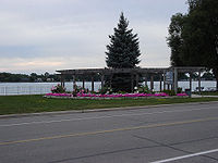
St. Clair Parkway
The presence of the St. Clair ParkwaySt. Clair Parkway
The Saint Clair Parkway is maintained by the Saint Clair Parks Commission. The road was the original Highway 40, which was re-aligned about 5 km inland from the river on a new alignment as a Super-2 expressway from Wallaceburg to Sarnia...
has given St. Clair Township a reputation for its beautiful parks along the riverfront. The head office had been located in Corunna since 1968. As of February 2006, the St. Clair Parkway has been disbanded and the parks have been handed over to the municipalities where they are located.
Notable people
- Maude Menten, pioneering chemist. Broke ground as a woman and with her famous contribution to scientific thought, the Michaelis-Menten equation. She was born in Port Lambton on March 20, 1879.