

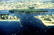
Lake Worth Inlet
Encyclopedia
Bar (landform)
A shoal, sandbar , or gravelbar is a somewhat linear landform within or extending into a body of water, typically composed of sand, silt or small pebbles. A spit or sandspit is a type of shoal...
connecting the northern part of the Lake Worth Lagoon
Lake Worth Lagoon
The Lake Worth Lagoon is a lagoon located in Palm Beach County, Florida. It runs parallel to the coast, and is separated from the Atlantic Ocean by barrier beaches, including Palm Beach Island. The lagoon is connected to the Atlantic Ocean by two permanent, man-made inlets.-Geography:Lake Worth...
in Palm Beach County, Florida
Palm Beach County, Florida
Palm Beach County is the largest county in the state of Florida in total area, and third in population. As of 2010, the county's estimated population was 1,320,134, making it the twenty-eighth most populous in the United States...
with the Atlantic Ocean
Atlantic Ocean
The Atlantic Ocean is the second-largest of the world's oceanic divisions. With a total area of about , it covers approximately 20% of the Earth's surface and about 26% of its water surface area...
. It is bordered by the town of Palm Beach
Palm Beach, Florida
The Town of Palm Beach is an incorporated town in Palm Beach County, Florida, United States. The Intracoastal Waterway separates it from the neighboring cities of West Palm Beach and Lake Worth...
on the south, and by the town of Palm Beach Shores
Palm Beach Shores, Florida
Palm Beach Shores is a town in Palm Beach County, Florida, United States. The population was 1,269 at the 2000 census. As of 2004, the population recorded by the U.S. Census Bureau was 1,511.-Geography:...
to the north. The inlet is also the entrance channel for the Port of Palm Beach
Port of Palm Beach
The Port of Palm Beach is located in Riviera Beach, Florida, in Palm Beach County. The Port is an independent taxing district, with a five-member board of commissioners elected at large by voters within the district. The Port district covers a land area of or approximately fifty percent of the...
. Its coordinates are 26°46′20"N 80°02′14"W.
In the mid-19th century the body of water that is now the Lake Worth Lagoon was a fresh water lake. This had been named Lake Worth in honor of William J. Worth
William J. Worth
William Jenkins Worth was a United States general during the Mexican-American War.-Early life:Worth was born in 1794 in Hudson, New York, to Thomas Worth and Abigail Jenkins. Both of his parents were Quakers, but he rejected the pacifism of their faith...
, commander of the Eighth Infantry Regiment in the Second Seminole War
Seminole Wars
The Seminole Wars, also known as the Florida Wars, were three conflicts in Florida between the Seminole — the collective name given to the amalgamation of various groups of native Americans and Black people who settled in Florida in the early 18th century — and the United States Army...
. There were no rivers or streams flowing into the lake; all of the flow into the lake was by ground seepage from the Everglades
Everglades
The Everglades are subtropical wetlands in the southern portion of the U.S. state of Florida, comprising the southern half of a large watershed. The system begins near Orlando with the Kissimmee River, which discharges into the vast but shallow Lake Okeechobee...
to the west. The only outflow from the lake was through a swamp
Swamp
A swamp is a wetland with some flooding of large areas of land by shallow bodies of water. A swamp generally has a large number of hammocks, or dry-land protrusions, covered by aquatic vegetation, or vegetation that tolerates periodical inundation. The two main types of swamp are "true" or swamp...
that became the Lake Worth Creek as it approached the Loxahatchee River
Loxahatchee River
The Loxahatchee River The Loxahatchee River The Loxahatchee River (Seminole for river of turtles is a 7.6 mile river near the southeast coast of Florida. It is a National Wild and Scenic River, one of only two in the state, and received its federal designation on May 17, 1985. The 1930s pioneer...
and Jupiter Inlet.
In 1866 travelers reported that fresh water was pouring out of the lake into the ocean at a point about ten miles south of the Jupiter Inlet. One report is that a settler named Lang had dug the channel to open an inlet, and it was known as Lang's Inlet for a while. This cut drained the lake down to sea level. The limited inflow of ocean water through the inlet and continued seepage of fresh water from the Everglades kept the lake from becoming more than mildly brackish
Brackish water
Brackish water is water that has more salinity than fresh water, but not as much as seawater. It may result from mixing of seawater with fresh water, as in estuaries, or it may occur in brackish fossil aquifers. The word comes from the Middle Dutch root "brak," meaning "salty"...
.
The inlet tended to silt up, and had to be dug out again every few months. In 1877 the settlers around the lake decided to dig a new inlet at a point about a mile north of Lang's Inlet where a rock formation called the Black Rocks would provide some protection for the inlet. The point chosen on the barrier island was only about 300 feet wide, but the beach dune
Dune
In physical geography, a dune is a hill of sand built by wind. Dunes occur in different forms and sizes, formed by interaction with the wind. Most kinds of dunes are longer on the windward side where the sand is pushed up the dune and have a shorter "slip face" in the lee of the wind...
ridge was 20 feet high and covered by heavy growth. All of the work was done with axes, shovels, hoes and wheelbarrows. It took 20 men several weeks to dig the new inlet.
The new inlet served its intended purpose well. The inlet tended to migrate south, however, with the current wearing away at the southern bank and depositing sand on the northern bank. By 1886 the inlet had migrated about a mile south of the Black Rocks, and closed up during a storm. An inlet was again dug through just south of the Black Rocks.
In 1893 Henry Flagler, who would complete construction of his Florida East Coast Railway
Florida East Coast Railway
The Florida East Coast Railway is a Class II railroad operating in the U.S. state of Florida; in the past, it has been a Class I railroad.Built primarily in the last quarter of the 19th century and the first decade of the 20th century, the FEC was a project of Standard Oil principal Henry Morrison...
to West Palm Beach
West Palm Beach, Florida
West Palm Beach, is a city located on the Atlantic coast in southeastern Florida and is the most populous city in and county seat of Palm Beach County, the third most populous county in Florida with a 2010 population of 1,320,134. The city is also the oldest incorporated municipality in South Florida...
in 1894, had the inlet enlarged. The federal
United States
The United States of America is a federal constitutional republic comprising fifty states and a federal district...
government turned down a request to improve the inlet in 1912. In 1915 the Florida Legislature
Florida Legislature
The Florida State Legislature is the term often used to refer to the two houses that act as the state legislature of the U.S. state of Florida. The Florida Constitution states that "The legislative power of the state shall be vested in a legislature of the State of Florida," composed of a Senate...
chartered the Lake Worth Inlet District (which later became the Port of Palm Beach District). The site of the original Lang's Inlet was chosen for the new inlet, which was completed in 1917.
The old inlet at the Black Rocks was still open. A community of fishermen from the Bahamas had settled on the barrier island just north of the Black Rocks, and they periodically cleared the channel when it silted up. A storm closed the inlet at the Black Rocks in 1919, and the fishermen, who were squatting on the island, were forced off by its owners and moved to Riviera (now Riviera Beach
Riviera Beach, Florida
Riviera Beach is a city in Palm Beach County, Florida, U.S.A. which was incorporated September 29, 1922. Because of where its eastern boundary lies, it is also the easternmost municipality in the South Florida metropolitan area. The population was 29,884 at the 2000 census. As of 2004, the...
).
The new Lake Worth Inlet was improved several times over the next decade. The federal government assumed responsibility for the inlet in 1935, and continued to widen and deepen it and build up the jetties
Jetty
A jetty is any of a variety of structures used in river, dock, and maritime works that are generally carried out in pairs from river banks, or in continuation of river channels at their outlets into deep water; or out into docks, and outside their entrances; or for forming basins along the...
. In 1967 the inlet was dredged to a depth of 35 feet, which has been maintained since then. A sand transfer plant pumps sand from the north side of the inlet to the south side in order to maintain the natural flow of sand southward along the coast.